We have some great sponsors for the Weather Talk Blog. Please let our sponsors know that you appreciate their support for the Weather Talk Blog.
Milner and Orr Funeral Home and Cremation Services located in Paducah, Kentucky and three other western Kentucky towns – at Milner and Orr they believe in families helping families. You can find Milner and Orr on Facebook, as well.
![]()
.

Wortham Dental Care located in Paducah, Kentucky. The gentle dentist. Mercury free dentistry. They also do safe Mercury removal. You can find Wortham Dental Care on Facebook, as well
.

Trover’s Equipment and Lawn Care – Family owned and operated! They are a dealer for Snapper, Simplicity, Snapper Pro, Bad Boy Mowers, and Intimidator Utility Vehicles. They are a Stihl and Dolmar power products dealer. They also are a dealer for Briggs & Stratton, Kohler gas & diesel engines, and Kawasaki engines. They service and repair just about any brand. You can find them on Facebook, as well
.

Visit their web-site here. Or, you can also visit their Facebook page.
.

Endrizzi’s Storm Shelters – For more information click here. Endrizzi Contracting and Landscaping can be found on Facebook, as well – click here
.
Are you looking for a full service insurance agency that writes homes, businesses, and vehicles in Illinois, Kentucky, and Tennessee. Call Gary’s office at 270.442.8234 for rates and plans to protect what matters to you!

Gary Eckelkamp’s web-site click the above banner or click here
.

This forecast update covers far southern Illinois, far southeast Missouri, and far western Kentucky. See the coverage map on the right side of the blog.
Remember that weather evolves. Check back frequently for updates, especially during active weather.
The forecast numbers below may vary a bit across the region. These are the averages.
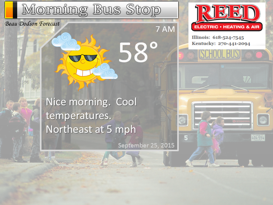
Thursday night – Mostly clear sky conditions. Patchy morning for possible.
Temperatures: Lows in the upper 50’s.
Winds: Southeast winds at 5 mph.
My confidence in this part of the forecast verifying is high
Should I cancel my outdoor plans? No
Is severe weather expected? No
What is the chance for precipitation? 0%
What impact is expected? No real impacts.
What impact is expected? None
Don’t forget to Tweet me your sunrise/sunset photos, storm photos, or other weather related photographs. I will try to retweet them or use them in the blog.
https://twitter.com/BeauDodson
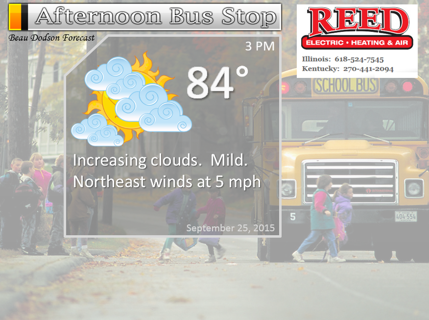
Friday – Partly sunny. Mild. Dry. Increasingly cloudy towards the afternoon and evening hours.
Temperatures: Highs in the lower to middle 80’s.
Winds: South winds at 5-10 mph
My confidence in this part of the forecast verifying is high
Should I cancel my outdoor plans? No
Is severe weather expected? No
What is the chance for precipitation? 10%
What impact is expected? No real impacts.
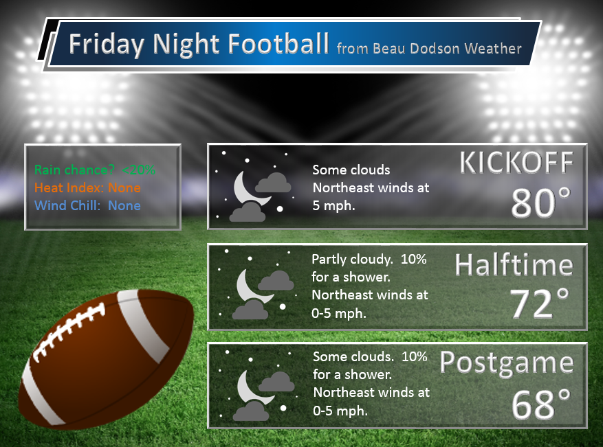
Friday night – Cloudy. A chance for a shower or two. Light, if they occur.
Temperatures: Lows in the lower 60’s.
Winds: Northeast winds at 5 mph.
My confidence in this part of the forecast verifying is high
Should I cancel my outdoor plans? No
Is severe weather expected? No
What is the chance for precipitation? 20%-30%
What impact is expected? No real impacts.
What impact is expected? None
Saturday – Quite a few clouds in the region. A couple of light showers not out of the question.
Temperatures: Highs in the middle 70’s. Maybe a bit warmer where the sun pokes out.
Winds: Northeast winds at 5-10 mph
My confidence in this part of the forecast verifying is medium
Should I cancel my outdoor plans? No
Is severe weather expected? No
What is the chance for precipitation? 20%-30%
What impact is expected? No real impacts.
Saturday night – Some clouds. A scattered shower or two possible.
Temperatures: Lows in the lower 60’s.
Winds: Southeast winds at 5 mph.
My confidence in this part of the forecast verifying is medium
Should I cancel my outdoor plans? No
Is severe weather expected? No
What is the chance for precipitation? 20%-30%
What impact is expected? No real impacts.
What impact is expected? None
Sunday – Some clouds. Small chance for a few showers.
Temperatures: Highs in the upper 70’s and lower 80’s.
Winds: South/southeast winds at 5-10 mph
My confidence in this part of the forecast verifying is medium
Should I cancel my outdoor plans? No
Is severe weather expected? No
What is the chance for precipitation? 20%
What impact is expected? No real impacts.
Sunday night – Some clouds. Mild for late September.
Temperatures: Lows in the lower 60’s.
Winds: Southeast winds at 5 mph.
My confidence in this part of the forecast verifying is high
Should I cancel my outdoor plans? No
Is severe weather expected? No
What is the chance for precipitation? 10%
What impact is expected? No real impacts.
What impact is expected? None
Monday – Partly sunny and mild.
Temperatures: Highs in the upper 70’s and lower 80’s.
Winds: South/southeast winds at 5-10 mph
My confidence in this part of the forecast verifying is high
Should I cancel my outdoor plans? No
Is severe weather expected? No
What is the chance for precipitation? 0%
What impact is expected? No real impacts.
The School Bus Stop Forecast is sponsored by Reed Electric, Heating & Air in Metropolis, IL offers full electrical, heating, and air conditioning services, as well as automatic transfer generators. Our licensed and insured service technicians serve Southern Illinois and Western KY with 24 hour service. Free estimates available for all new installations!
Click their ad below to visit their web-site or click here reedelec.com


![]()

Don’t forget to check out the Southern Illinois Weather Observatory web-site for weather maps, tower cams, scanner feeds, radars, and much more! Click here

An explanation of what is happening in the atmosphere over the coming days…
Highlights
1. Clouds will be on the increase over the coming days
2. Small precipitation chances as an upper level low pushes northwest
3. Mild weekend.
4. Maybe a cold front next week
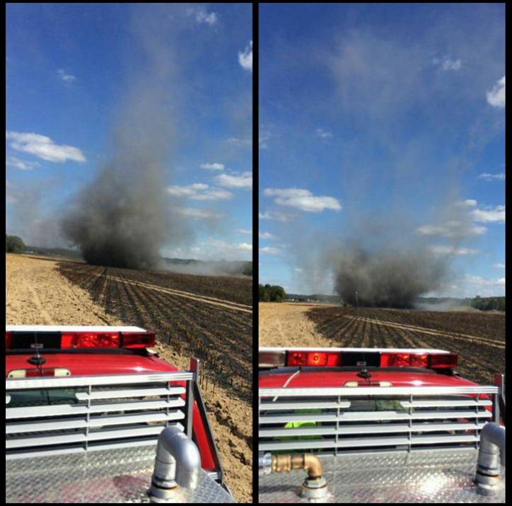
Dry weather continues. I have viewed a few brush fire photographs over the last few days. At least the winds have been light. That has helped fire departments and kept the problems to a minimum.
This photograph was from the Ohio County, KY (Fordsville) Fire Department. That is a dust devil made up of smoke, soot, and some fire.
The photographer is Waymon Bratcher. Thanks, guys for the photograph share.
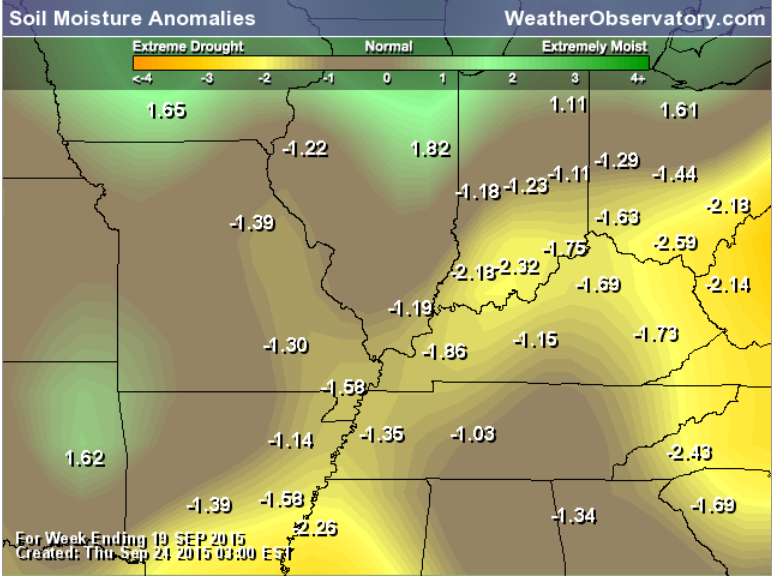
Soil Moisture Anomalies
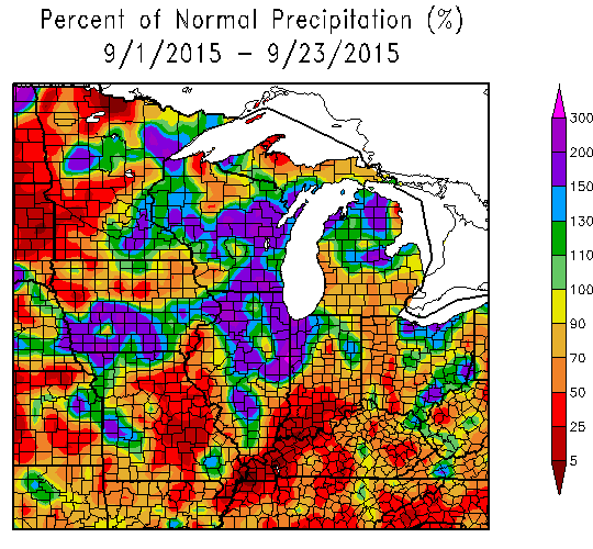
Here is the percent of normal precipitation map (below). Check this out, folks. Those are amazing numbers. Parts of our region have received 5-10% of normal rainfall since September 1st. Did you think it was dry? We, it is. For most, at least. Parts of southeast Missouri and southern Illinois did pick up some decent rain earlier this month.
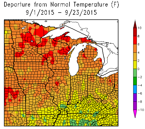
Here are temperatures. They have been above normal this month, as well.
The next few days:
We will see slow weather changes over the coming days.
An upper level low will push into our region from the southeast. Southeast, you say? Yes. That is an odd path. But, during the summer months and early fall months we can have these tropical like lows push in odd directions. This one will move towards us from the southeast United States.
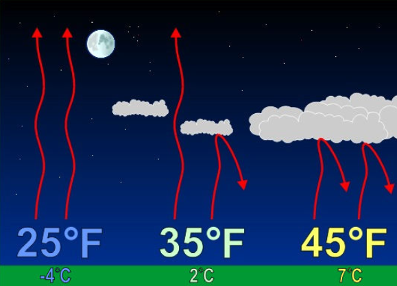
This will help push clouds into our region. This will begin on Friday and last into the weekend. The end result will be slightly cooler temperatures during the day. It will also mean slightly warmer temperatures at night. Clouds can act like a blanket at night. We don’t have the radiational cooling when we have cloud cover. Thus, overnight lows will tick upward a bit.
Here is an example graphic that I found online. Of course, we aren’t dealing with these temperatures. But, you get the general idea about radiational cooling.
Precipitation chances?
I can’t rule out some scattered light showers with this upper level low. The best chances would be the pennyrile area of western Kentucky and down into Tennessee. Also parts of southern Indiana (outside of my area).
Rainfall amounts would be less than 0.10″. That is how it appears, at this time. With that said, some of the models paint a bit more rain. The NAM model is one of those models. It typically does fairly well in the short range. Let’s keep an eye on this. I will update this post (at the top) if there are changes.
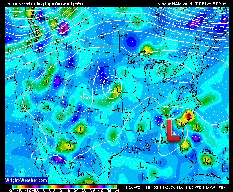
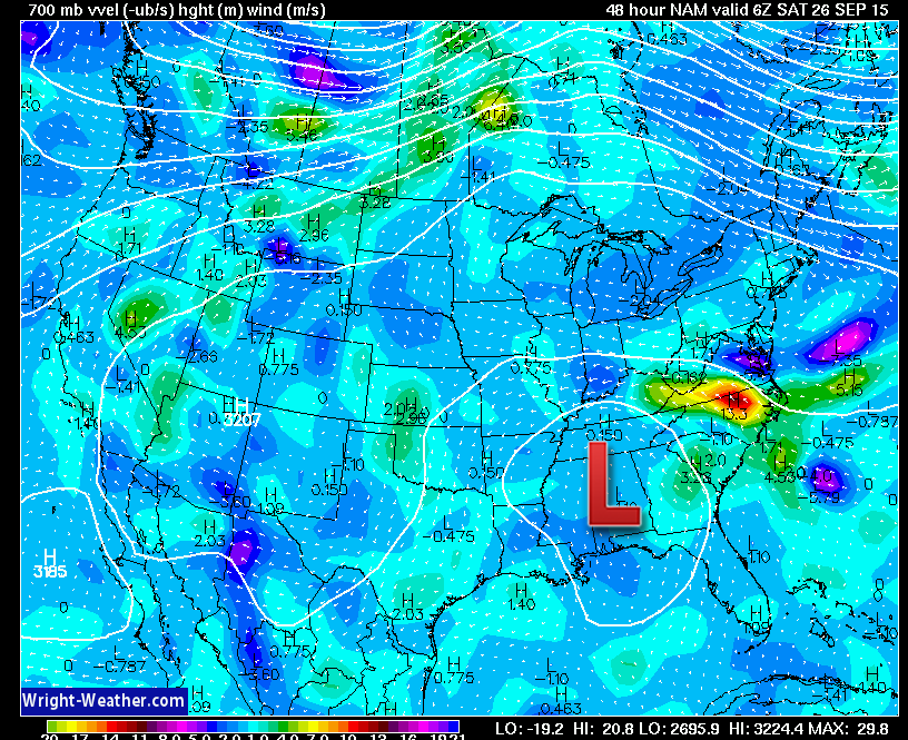
Let’s look at this upper level low on the models. These images are from wright-weather.com
Notice how the low backs towards the west. This first image is for Friday morning at 3 am. See the low over the southeast United States? The big red L.
Now, notice how it backs west by Saturday night?
Again, the main result of this will be an increase in clouds. Whether we will experience a few showers is still a question mark.
The main time frame for a few showers would be Friday night into Saturday evening.
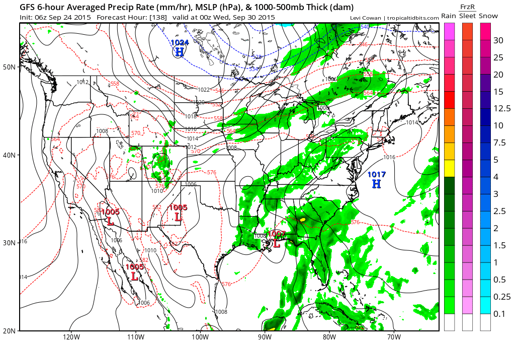
Another cold front may approach the region next week. But, the models are all over the place with the details. Our track record of rain has not been great during the Month of September. Especially if you live in southern Indiana, far southern Illinois, the Missouri Bootheel, western Kentucky, and western Tennessee. Let’s see if we can pop some showers and storms next week.
Here is what the GFS shows for next Tuesday and Tuesday night. A few showers? We shall see. I don’t get my hopes up for rain, as of late.
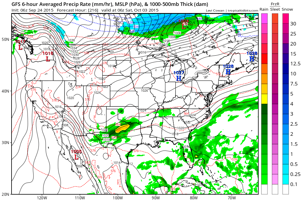
And, since I am a wee bit weather bored – check out this map for October 3rd. Snow in Canada! I wanted to toss you cold weather lovers something to talk about.
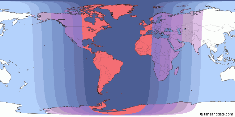
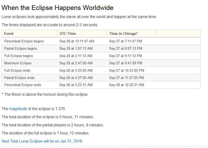
LUNAR ECLIPSE SUNDAY NIGHT.
But, there might be clouds in our region. Could mess up the viewing opportunity. We shall see.
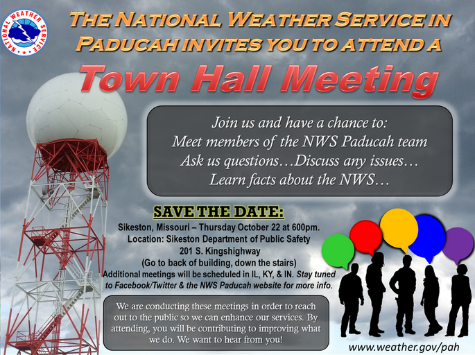
The National Weather Service is planning a town hall meeting! The first one will be in Sikeston, Missouri.
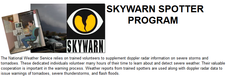
Are you interested in becoming a severe weather spotter? We need more spotters.
Radars
WEATHER RADAR PAGE – Click here —
Don’t forget to support our sponsors!

How much precipitation should we expect over the next few days?
Small rain chances over the weekend. At this time, it does not appear that significant rain is going to occur. Maybe a few spots pick up 0.05″-0.10″. Many areas will remain dry.

Can we expect severe thunderstorms over the next 24 to 48 hours? Remember that a severe thunderstorm is defined as a thunderstorm that produces 58 mph winds or higher, quarter size hail or larger, and/or a tornado.
Thunderstorm threat level will be near ZERO for Friday into Sunday.
.
Friday: Severe weather is not anticipated.
Saturday: Severe weather is not anticipated.
Sunday: Severe weather is not anticipated.
Monday: Severe weather is not anticipated.
Tuesday: Severe weather is not anticipated.
Wednesday: Severe weather is not anticipated.
Thursday: Severe weather is not anticipated.


Calm weather for Friday. An increase in clouds with small shower chances Friday night into the weekend. Precipitation would move from southeast to northwest. A bit odd, but not unheard of. That is IF we can actually pick up a few showers.

I also set up a storm tracking page with additional links (use during active weather for quick reference)
Storm Tracking Tool Page

Here are the current river stage forecasts. You can click your state and then the dot for your location. It will bring up the full forecast and hydrograph.
Click Here For River Stage Forecasts…
Here are some current forecast hydrographs. These will be updated each day with new information.


Smithland Lock and Dam

Paducah, Kentucky Forecast Stage

Cairo, Illinois

Cape Girardeau, Missouri
Current Temperatures Around The Local Area


We have regional radars and local city radars – if a radar does not seem to be updating then try another one. Occasional browsers need their cache cleared. You may also try restarting your browser. That usually fixes the problem. Occasionally we do have a radar go down. That is why I have duplicates. Thus, if one fails then try another one.
If you have any problems then please send me an email beaudodson@usawx.com
WEATHER RADAR PAGE – Click here —
We also have a new national interactive radar – you can view that radar by clicking here.
Local interactive city radars include St Louis, Mt Vernon, Evansville, Poplar Bluff, Cape Girardeau, Marion, Paducah, Hopkinsville, Memphis, Nashville, Dyersburg, and all of eastern Kentucky – these are interactive radars. Local city radars – click here
NOTE: Occasionally you will see ground clutter on the radar (these are false echoes). Normally they show up close to the radar sites – including Paducah.

Regional Radar – Click on radar to take you our full radar page.


Regional Radar

Live Lightning Data – zoom and pan: Click here
Live Lightning Data with sound (click the sound button on the left side of the page): Click here
I also set up a storm tracking page with additional links (use during active weather for quick reference)
Storm Tracking Tool Page
![]()
Current WARNINGS (a warning means take action now). Click on your county to drill down to the latest warning information. Keep in mind that there can be a 2-3 minute delay in the updated warning information.
I strongly encourage you to use a NOAA Weather Radio or warning cell phone app for the most up to date warning information. Nothing is faster than a NOAA weather radio.


Color shaded counties are under some type of watch, warning, advisory, or special weather statement. Click your county to view the latest information.

Missouri Warnings

Illinois Warnings

Kentucky Warnings

Here is the official 6-10 day and 8-14 day temperature and precipitation outlook. Check the date stamp at the top of each image (so you understand the time frame).
The forecast maps below are issued by the Weather Prediction Center (NOAA).


The latest 8-14 day temperature and precipitation outlook. Note the dates are at the top of the image. These maps DO NOT tell you how high or low temperatures or precipitation will be. They simply give you the probability as to whether temperatures or precipitation will be above or below normal.


Who do you trust for your weather information and who holds them accountable?
I have studied weather in our region since the late 1970’s. I have 37 years of experience in observing our regions weather patterns. My degree is in Broadcast Meteorology from Mississippi State University and an Associate of Science (AS). I am currently working on my Bachelor’s Degree in Geoscience.
My resume includes:
Member of the American Meteorological Society.
NOAA Weather-Ready Nation Ambassador.
Meteorologist for McCracken County Emergency Management.
I own and operate the Southern Illinois Weather Observatory.
Recipient of the Mark Trail Award, WPSD Six Who Make A Difference Award, Kentucky Colonel, and the Caesar J. Fiamma” Award from the American Red Cross.
In 2009 I was presented with the Kentucky Office of Highway Safety Award.
Recognized by the Kentucky House of Representatives for my service to the State of Kentucky leading up to several winter storms and severe weather outbreaks.
I am also President of the Shadow Angel Foundation which serves portions of western Kentucky and southern Illinois.
There is a lot of noise on the internet. A lot of weather maps are posted without explanation. Over time you should learn who to trust for your weather information.
My forecast philosophy is simple and straight forward.
- Communicate in simple terms
- To be as accurate as possible within a reasonable time frame before an event
- Interact with you on Twitter, Facebook, and the blog
- Minimize the “hype” that you might see on television or through other weather sources
- Push you towards utilizing wall-to-wall LOCAL TV coverage during severe weather events
I am a recipient of the Mark Trail Award, WPSD Six Who Make A Difference Award, Kentucky Colonel, and the Caesar J. Fiamma” Award from the American Red Cross. In 2009 I was presented with the Kentucky Office of Highway Safety Award. I was recognized by the Kentucky House of Representatives for my service to the State of Kentucky leading up to several winter storms and severe weather outbreaks.
If you click on the image below you can read the Kentucky House of Representatives Resolution.

Many of my graphics are from www.weatherbell.com – a great resource for weather data, model data, and more


You can sign up for my AWARE email by clicking here I typically send out AWARE emails before severe weather, winter storms, or other active weather situations. I do not email watches or warnings. The emails are a basic “heads up” concerning incoming weather conditions.