Friday, September 22, 2017
.
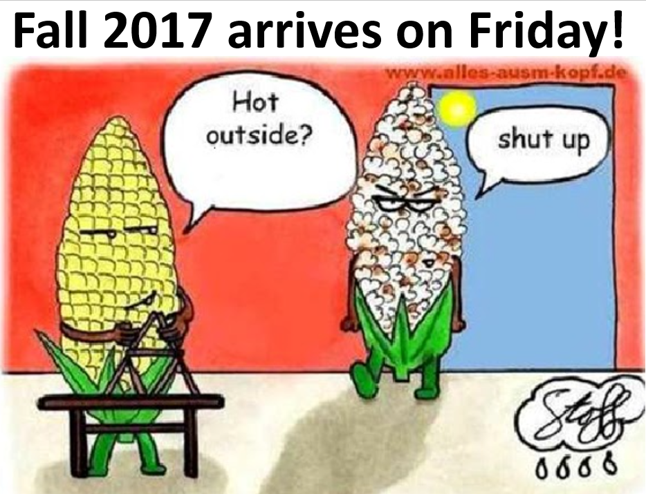
WELCOME TO FALL!
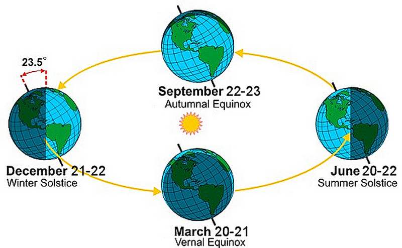
Well, almost. Fall arrives later today, but we can celebrate early.
.
Forecast highlights:
.
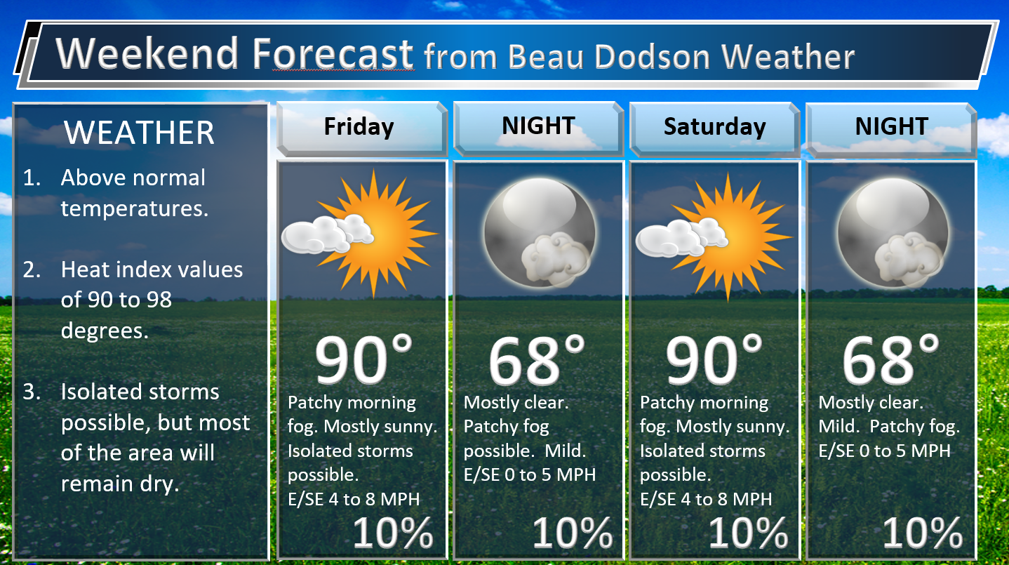
1. Above normal temperatures to continue all weekend
2. Isolated heavy thunderstorms possible, but most areas will remain dry
3. Strong cold front next week will usher in below normal temperatures
.
TODAY INTO THIS WEEKEND:
Today is the first day of fall, but nature won’t cooperate. We will once again watch temperatures rise into the upper 80’s and lower 90’s.
This is well above the seasonal norms. Normal high temperatures, for this time of the year, are around 78 to 80 degrees.
Heat index values of 94 to 98 are likely by later this afternoon. Humid air for September.
Enjoy the warm weather. We know it won’t last!
Isolated thunderstorms will occur again today. Most of the area will remain dry. A few areas could have heavy downpours, lightning, gusty winds, and small hail.
Coverage will be isolated. Keep that in mind. I have chances capped at around 10% to 15%.
What does a 10% chance of rain mean? It means there will likely be some thunderstorms on radar, but odds favor your location remaining dry.
WEEKEND:
No change for Saturday and Sunday. More of the same.
NEXT WEEK:
A strong cold front will arrive on Wednesday into Thursday.
This front might spark some thunderstorms.
The big weather story, however, will be the cooler temperatures.
Highs may remain in the 70’s by next Thursday and Friday. It will feel a bit more fallish.
We might even see overnight lows dip into the 40’s late next week.
Here is the temperature outlook for October 1st through 5th


FROST FORECAST:
No frost in the forecast through next Thursday.
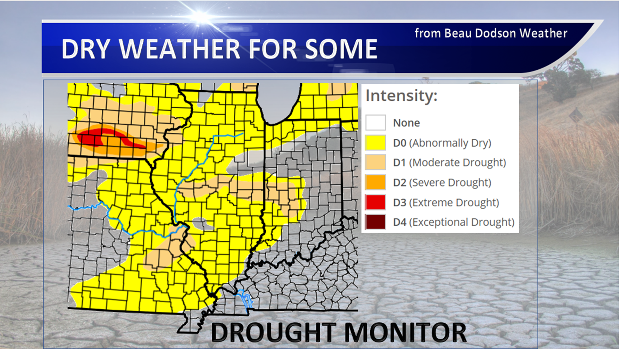
The official October forecast is for above normal temperatures and below normal rainfall.
The drought, for portions of our region, will likely worsen.
Drought monitor update
Most of Illinois is abnormally dry.
Notice Massac County and a portion of Pope County have been removed. This is because of some heavy rain a few weeks ago. This occurred over the southeast portion of Massac County and portions of southern Pope County. It was a late night storm that dropped two to four inches of rain.
They should have left a good chunk of Massac County in the abnormally dry.
Click to enlarge.


.
A Weather Talk subscription ($3 a month) is required to view the videos.
Videos are posted on the www.weathertalk.com website. Once there, click the Beau Video-Cast tab. Long Range Video Update
If you believe you missed a video then you may check the LIVE FEED link on the Weather Talk website. You will find an archive of videos on that page.
You can also receive the videos via your Weather Talk app/text messages. Have text option FOUR activated. The Weather Extra text option. Sign up for the app/text messages, videos, and more at www.beaudodsonweather.com
.

.
This forecast update covers southern Illinois, southeast Missouri, western Kentucky. and extreme northwest Tennessee.
.
September 21, 2017
Thursday Night Forecast Details:
Forecast: A few clouds. Warm. Patchy fog late. Only a 10% chance of an evening storm.
Temperatures: MO ~ 68 to 72 IL ~ 68 to 72 KY ~ 68 to 72 TN ~ 68 to 72
Winds: South and southeast at 0 to 5 mph
What impacts are anticipated from the weather? Isolated wet roadways. Lightning. Low visibility in areas with fog.
My confidence in the forecast verifying: Medium
Is severe weather expected? No
The NWS defines severe weather as 58 mph winds or great, 1″ hail or larger, and/or tornadoes
What is the chance of precipitation? MO ~ 10% IL ~ 10% KY ~ 10% TN ~ 10%
Coverage of precipitation: Isolated
Should I cancel my outdoor plans? No, but monitor updates
.
Welcome to fall 2017!
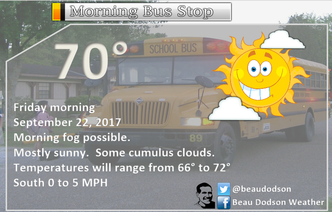
September 22, 2017
Friday Forecast Details
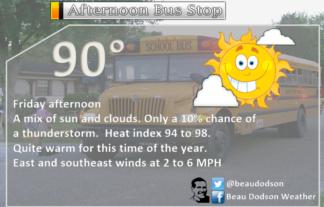
Forecast: Mostly sunny. Heat index above 95 degrees. Some cumulus clouds. Warm and humid. A 10% chance of an isolated afternoon thunderstorm. A 10% chance means that there will probably be a few storms on radar, but most of the area will remain dry.
Temperatures: MO ~ 86 to 92 IL ~ 86 to 92 KY ~ 86 to 92 TN ~ 86 to 92
Winds: East and southeast at 4 to 8 mph
What impacts are anticipated from the weather? Most likely none. Isolated lightning and wet roadways.
My confidence in the forecast verifying: Medium
Is severe weather expected? No
The NWS defines severe weather as 58 mph winds or great, 1″ hail or larger, and/or tornadoes
What is the chance of precipitation? MO ~ 20% IL ~ 10% KY ~ 10% TN ~ 20%
Coverage of precipitation: None to isolated
Should I cancel my outdoor plans? No
.
Friday Night Forecast Details:
Forecast: Evening clouds giving way to clear sky conditions. Patchy fog. Mild. Only a 10% of an evening storm.
Temperatures: MO ~ 66 to 72 IL ~ 66 to 72 KY ~ 66 to 72 TN ~ 66 to 72
Winds: Southeast at 0 to 5 mph
What impacts are anticipated from the weather? Slight chance for evening wet roadways and lightning. Lower visibility if fog forms
My confidence in the forecast verifying: Medium
Is severe weather expected? No
The NWS defines severe weather as 58 mph winds or great, 1″ hail or larger, and/or tornadoes
What is the chance of precipitation? MO ~ 10% IL ~ 10% KY ~ 10% TN ~ 10%
Coverage of precipitation: None to isolated.
Should I cancel my outdoor plans? No
.
September 23, 2017
Saturday Forecast Details
Forecast: Mostly sunny. Heat index above 95 degrees. Some cumulus clouds. Warm and humid. A 10% chance of an isolated afternoon thunderstorm
Temperatures: MO ~ 86 to 92 IL ~ 86 to 92 KY ~ 86 to 92 TN ~ 86 to 92
Winds: East and southeast at 4 to 8 mph
What impacts are anticipated from the weather? Isolated wet roadways. Lightning.
My confidence in the forecast verifying: Medium
Is severe weather expected? Not at this time
The NWS defines severe weather as 58 mph winds or great, 1″ hail or larger, and/or tornadoes
What is the chance of precipitation? MO ~ 20% IL ~ 10% KY ~ 10% TN ~ 20%
Coverage of precipitation: None to Isolated
Should I cancel my outdoor plans? No
.
Saturday Night Forecast Details:
Forecast: Evening clouds giving way to clear sky conditions. Patchy fog. Mild. A 10% chance on an isolated evening storms possible.
Temperatures: MO ~ 66 to 72 IL ~ 66 to 72 KY ~ 68 to 72 TN ~ 68 to 72
Winds: Southeast at 0 to 5 mph
What impacts are anticipated from the weather? Slight chance for evening wet roadways and lightning. Lower visibility if fog forms
My confidence in the forecast verifying: Medium
Is severe weather expected? No
The NWS defines severe weather as 58 mph winds or great, 1″ hail or larger, and/or tornadoes
What is the chance of precipitation? MO ~ 10% IL ~ 10% KY ~ 10% TN ~ 10%
Coverage of precipitation: None to isolated.
Should I cancel my outdoor plans? No
.
September 24, 2017
Sunday Forecast Details
Forecast: Mostly sunny. Heat index above 95 degrees. Some cumulus clouds. Warm and humid. A 10% chance of an isolated afternoon thunderstorm
Temperatures: MO ~ 85 to 88 IL ~ 85 to 88 KY ~ 85 to 88 TN ~ 85 to 88
Winds: Southeast at 5 to 10 mph
What impacts are anticipated from the weather? Isolated wet roadways. Lightning.
My confidence in the forecast verifying: Medium
Is severe weather expected? Not at this time
The NWS defines severe weather as 58 mph winds or great, 1″ hail or larger, and/or tornadoes
What is the chance of precipitation? MO ~ 20% IL ~ 10% KY ~ 10% TN ~ 20%
Coverage of precipitation: None to isolated
Should I cancel my outdoor plans? No
.
Sunday Night Forecast Details:
Forecast: Evening clouds giving way to clear sky conditions. Patchy fog. Mild. Only a 10% chance of an evening storm.
Temperatures: MO ~ 63 to 66 IL ~ 63 to 66 KY ~ 63 to 66 TN ~ 63 to 66
Winds: South at 0 to 5 mph
What impacts are anticipated from the weather? Slight chance for evening wet roadways and lightning. Lower visibility if fog forms.
My confidence in the forecast verifying: Medium
Is severe weather expected? No
The NWS defines severe weather as 58 mph winds or great, 1″ hail or larger, and/or tornadoes
What is the chance of precipitation? MO ~ 10% IL ~ 10% KY ~ 10% TN ~ 10%
Coverage of precipitation: None to isolated.
Should I cancel my outdoor plans? No
.
September 25, 2017
Monday Forecast Details
Forecast: Mostly sunny. Some cumulus clouds. Warm and humid. A 10% chance of an isolated afternoon thunderstorm
Temperatures: MO ~ 86 to 90 IL ~ 85 to 88 KY ~ 86 to 90 TN ~ 86 to 90
Winds: Southeast at 5 to 10 mph
What impacts are anticipated from the weather? Isolated wet roadways. Lightning.
My confidence in the forecast verifying: Medium
Is severe weather expected? Not at this time
The NWS defines severe weather as 58 mph winds or great, 1″ hail or larger, and/or tornadoes
What is the chance of precipitation? MO ~ 10% IL ~ 10% KY ~ 10% TN ~ 10%
Coverage of precipitation: None to isolated
Should I cancel my outdoor plans? No
.
Monday Night Forecast Details:
Forecast: Evening clouds giving way to clear sky conditions. Patchy fog. Mild. A 10% chance of an evening storm.
Temperatures: MO ~ 63 to 66 IL ~ 63 to 66 KY ~ 63 to 66 TN ~ 63 to 66
Winds: South at 3 to 6 mph
What impacts are anticipated from the weather? Slight chance for evening wet roadways and lightning. Lower visibility if fog forms.
My confidence in the forecast verifying: Medium
Is severe weather expected? No
The NWS defines severe weather as 58 mph winds or great, 1″ hail or larger, and/or tornadoes
What is the chance of precipitation? MO ~ 10% IL ~ 10% KY ~ 10% TN ~ 10%
Coverage of precipitation: None to isolated.
Should I cancel my outdoor plans? No
.
September 26, 2017
Tuesday Forecast Details
Forecast: Mostly sunny. Some cumulus clouds. Warm and humid. A 10% chance of an isolated afternoon thunderstorm
Temperatures: MO ~ 86 to 88 IL ~ 86 to 88 KY ~ 86 to 88 TN ~ 86 to 88
Winds: Southeast at 5 to 10 mph
What impacts are anticipated from the weather? Isolated wet roadways. Lightning.
My confidence in the forecast verifying: Medium
Is severe weather expected? Not at this time
The NWS defines severe weather as 58 mph winds or great, 1″ hail or larger, and/or tornadoes
What is the chance of precipitation? MO ~ 10% IL ~ 10% KY ~ 10% TN ~ 10%
Coverage of precipitation: None to isolated
Should I cancel my outdoor plans? No
.
Tuesday Night Forecast Details:
Forecast: Evening clouds giving way to clear sky conditions. Patchy fog. Mild. A 10% chance of an evening storm.
Temperatures: MO ~ 63 to 66 IL ~ 63 to 66 KY ~ 63 to 66 TN ~ 63 to 66
Winds: South at 3 to 6 mph
What impacts are anticipated from the weather? Slight chance for evening wet roadways and lightning. Lower visibility if fog forms.
My confidence in the forecast verifying: Medium
Is severe weather expected? No
The NWS defines severe weather as 58 mph winds or great, 1″ hail or larger, and/or tornadoes
What is the chance of precipitation? MO ~ 10% IL ~ 10% KY ~ 10% TN ~ 10%
Coverage of precipitation: None to isolated.
Should I cancel my outdoor plans? No
Friday morning school bus stop forecast
Friday afternoon school bus stop forecast
.

The National Weather Service definition of a severe thunderstorm is one that produces quarter size hail or larger, 58 mph winds or greater, and/or a tornado.
Thursday night through Friday: Severe weather is not anticipated. There is a slight chance for isolated thunderstorms each day. This is especially true during the heat of the day. The vast amount of the region will remain dry.
If storms form, then they could produce locally heavy rain, gusty winds, and dime to nickel size hail. A small risk for a severe thunderstorm.
.

Overview
Highlights of the forecast.
- Hot
- Heat index in the 90’s
- Cold front late next week
Short range comments
Hot weather is here to stay.
Fall will arrive with above normal temperatures.
You can expect temperatures in the upper 80’s to around 90 degrees through next Tuesday.
Thunderstorm chances will be low. For the most part, the region will be dry. Isolated heat of the day storms are possible, but coverage will be very limited.
I am tracking a cool front for next week. See the long range discussion further down in this post.
Temperature Forecast
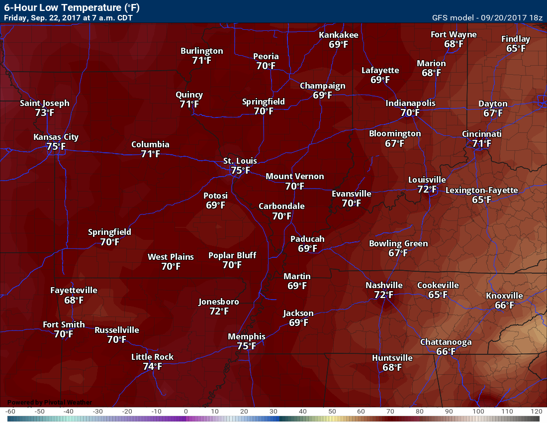
Thursday night low temperatures
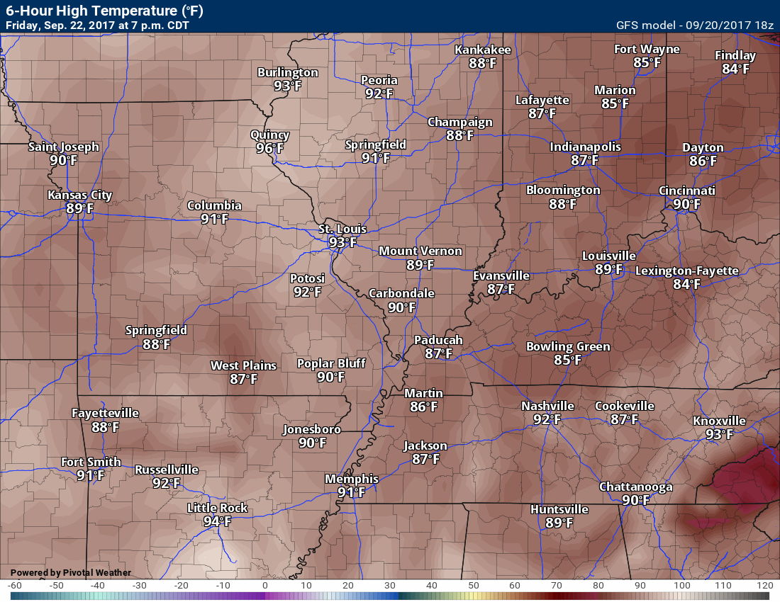
Friday high temperatures
Friday night low temperatures

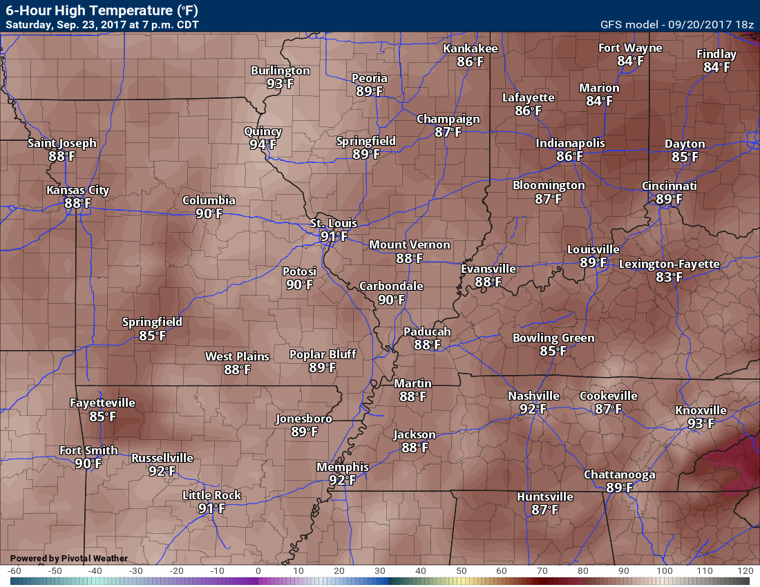
Saturday high temperatures
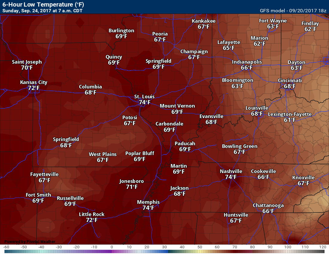
Saturday night low temperatures
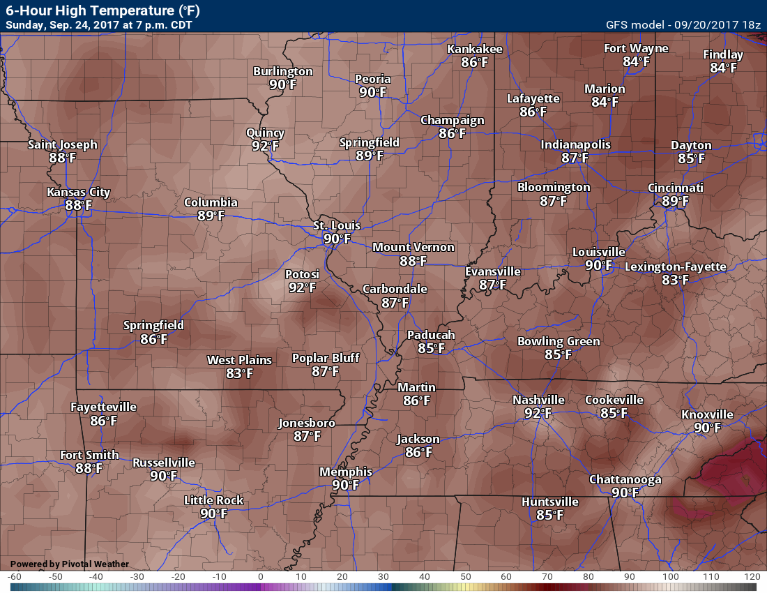
Sunday high temperatures
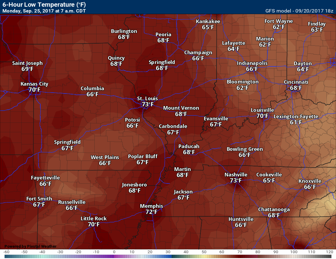
Sunday night low temperatures
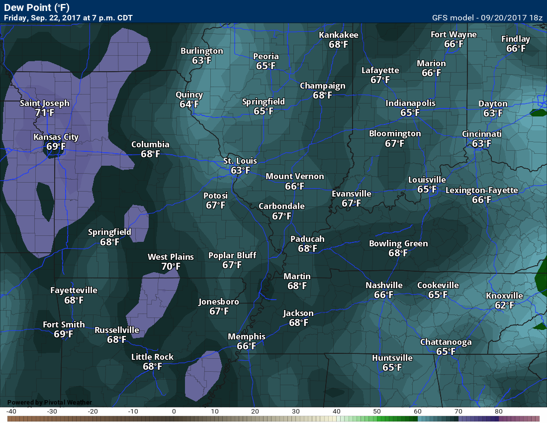
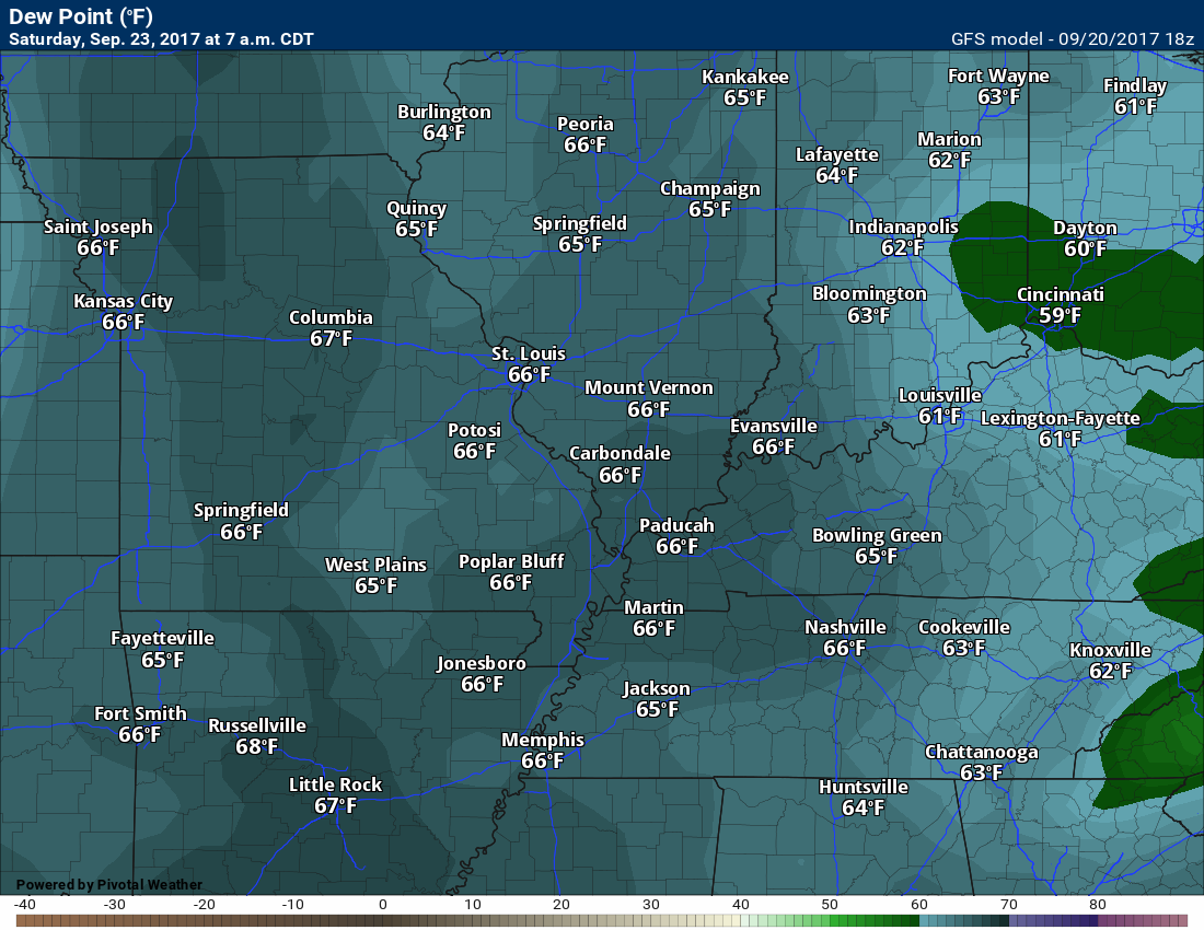
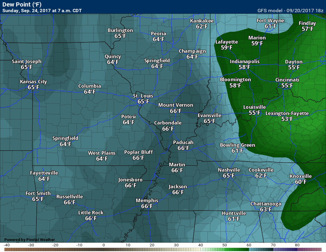
Dew point scale
Dew points are what control how you feel outside.

Click images to enlarge
Friday dew points
Saturday dew points
Sunday dew points
Long range comments
A cold front will move into the region towards the middle/end of next week. This front should deliver cooler weather and perhaps a band of showers and thunderstorms.
This does not look to be a heavy rain event. For now, the severe weather risk appears to be small.
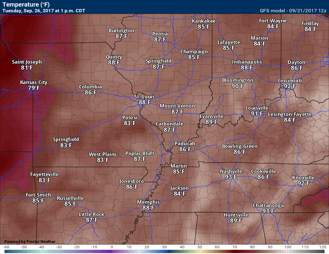
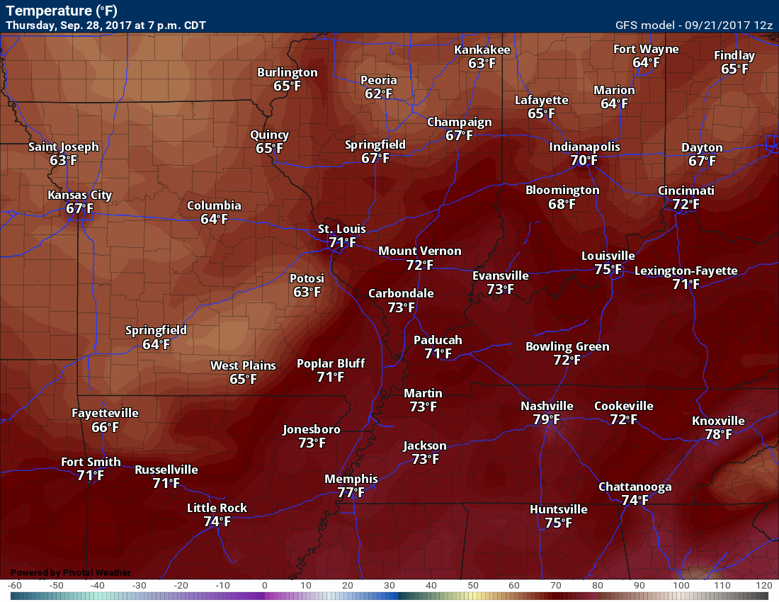
You can see the temperature difference on these two maps.
Here is the Tuesday afternoon temperature map
Tuesday temperatures. Warm!
Now take a look at the Thursday morning temperatures
Look towards Kansas City. There is a cold front between here and there.
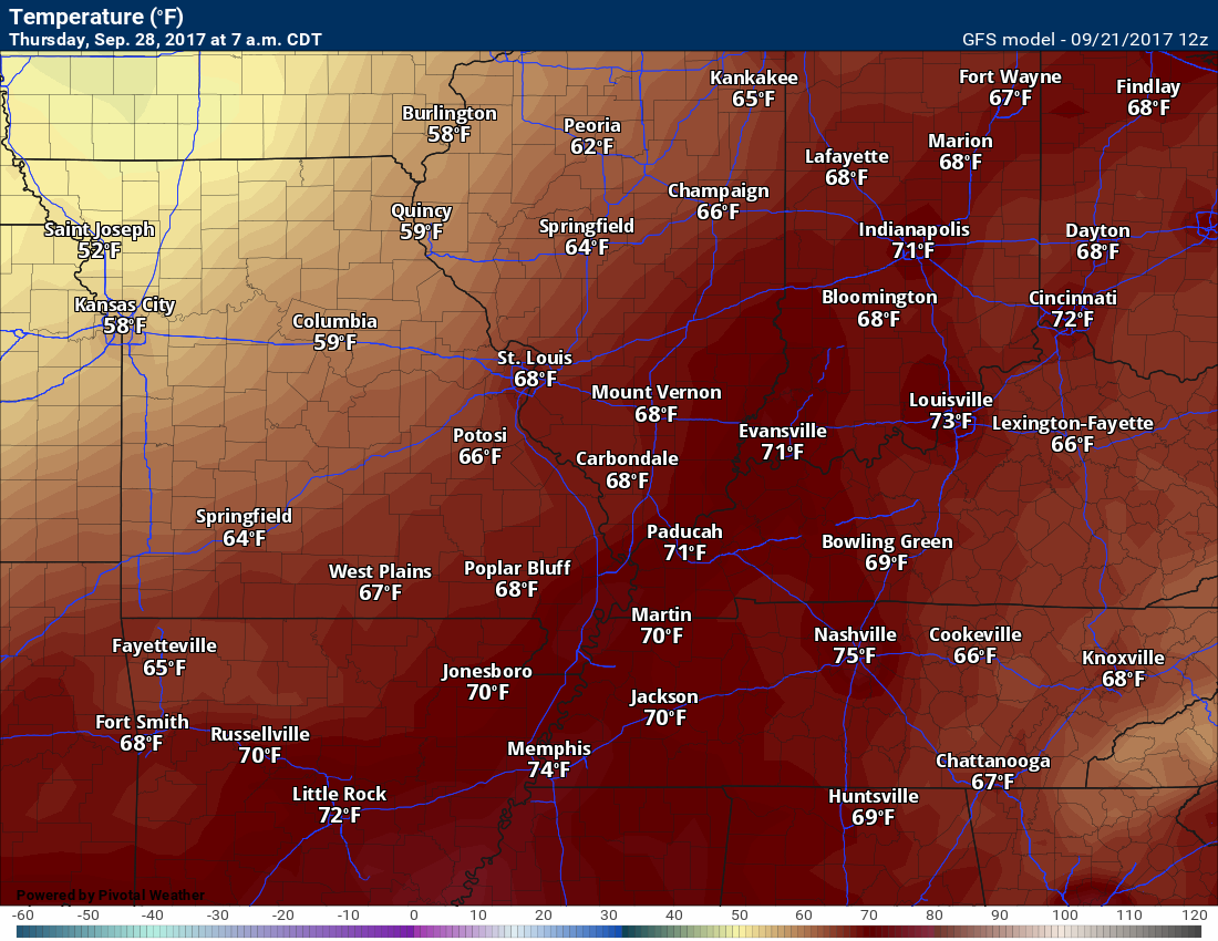
Thursday afternoon temperatures
Saturday morning temperatures

For those tired of the heat, there is some relief in sight.
With that said, above normal temperatures may return after this cool shot passes through the area.
The official October forecast is for above normal temperatures.
Are you subscribing to Weather Talk app/text messages and videos? This is what helps support all of the data you see each day.
We now offer premium videos for the short and long range forecasts! These videos are produced by a team of long range forecast experts. They are brought to you as bonus information. Activate text option four in order to receive these on your app or via text.
Subscribe at www.beaudodsonweather.com
We offer an Apple and Android app (scroll to the bottom of this page for more information).

Were you aware that I hired a team of meteorologists for long range videos?
To learn more, click this link
http://cms.weathertalk.com/meet-the-team/
.


We offer regional radars and local city radars – if a radar does not update then try another one. Occasional browsers need their cache cleared. You may also try restarting your browser. This will usually fix any problems.
During the winter you can track snow and ice by clicking the winterize button on the local city view interactive radars.
You may email me at beaudodson@usawx.com
Interactive Weather Radar Page. Choose the city nearest your location: Click this link
National interactive radar: Click this link.
The Beau Dodson Weather APP is ready for Apple and Android users. The app provides a faster way for you to receive my text messages. ATT and Verizon are not always reliable when it comes to speed.
Some of you have asked if you can receive the texts on your phone and the app. The answer to that is, yes. The Android app will automatically allow that to happen. On the Apple app, however, you will need to open your app and click the settings button. Make sure the green tab is OFF. Off means you will still receive the texts to your phone and the app. If you have any questions, then email me at beaudodson@usawx.com
The app is for text subscribers.
The direct download, for the Apple app, can be viewed here
https://itunes.apple.com/us/app/id1190136514
Here is the download link for the Android version Click Here
If you have not signed up for the texting service then you may do so at www.beaudodsonweather.com


——————————————————–
Your support helps with the following:

and

.

Whom do you trust for your weather information?
I have studied weather, in our region, since the late 1970’s. I have 40 years of experience in observing our regions weather patterns. My degree is in Broadcast Meteorology and a Bachelor’s of Science.
My resume includes:
Member of the American Meteorological Society.
NOAA Weather-Ready Nation Ambassador.
Meteorologist for McCracken County Emergency Management. I served from 2005 through 2015.
Meteorologist for McCracken County Rescue. 2015 through current
I own and operate the Southern Illinois Weather Observatory.
I am the chief meteorologist for Weather Talk LLC.
I am also a business owner in western Kentucky.
Recipient of the Mark Trail Award, WPSD Six Who Make A Difference Award, Kentucky Colonel, and the Caesar J. Fiamma” Award from the American Red Cross.
In 2005, I helped open the largest American Cross shelter in U.S. history. This was in Houston, Texas. I was deployed to help with the aftermath of Hurricane Katrina and Hurricane Rita. I was a shelter manager of one of the Houston, Texas shelter divisions.
In 2009 I was presented with the Kentucky Office of Highway Safety Award.
Recognized by the Kentucky House of Representatives for my service to the State of Kentucky leading up to several winter storms and severe weather outbreaks.
If you click on the image below you can read the Kentucky House of Representatives Resolution.

I am President of the Shadow Angel Foundation which serves portions of western Kentucky and southern Illinois.
There is a lot of noise on the internet. A lot of weather maps are posted without explanation. You need a trusted source for information.
My forecast philosophy is simple and straight forward.
- Communicate in simple terms
- To be as accurate as possible within a reasonable time frame before an event
- Interact with you on Twitter, Facebook, email, texts, and this blog
- Minimize the “hype” that you might see through other weather sources
- Push you towards utilizing wall-to-wall LOCAL TV coverage during severe weather events

Sign up for my AWARE email by clicking here.
I typically send AWARE emails before severe weather, winter storms, or other active weather situations. I do not email watches or warnings. The emails are a basic “heads up” concerning incoming weather conditions