WeatherTalk monthly operating costs can top $2000.00. Your $5 subscription helps pay for those costs. I work for you.
The $5 will allow you to register up to seven phones!
For $5 a month you can receive the following. You may choose to receive these via your WeatherTalk app or regular text messaging.
Severe weather app/text alerts from my keyboard to your app/cell phone. These are hand typed messages from me to you. During tornado outbreaks, you will receive numerous app/text messages telling you exactly where the tornado is located.
- Daily forecast app/texts from my computer to your app/cell phone.
- Social media links sent directly to your app/cell phone. When I update the blog, videos, or Facebook you will receive the link.
- AWARE emails. These emails keep you well ahead of the storm. They give you several days of lead time before significant weather events.
- Direct access to Beau via text and email. Your very own personal meteorologist. I work for you!
- Missouri and Ohio Valley centered video updates
- Long-range weather videos
- Week one, two, three and four temperature and precipitation outlooks.
Monthly outlooks. - Your subscription also will help support several local charities.
Would you like to subscribe? Subscribe at www.beaudodsonweather.com

I encourage subscribers to use the app vs regular text messaging. We have found text messaging to be delayed during severe weather. The app typically will receive the messages instantly. I recommend people have three to four methods of receiving their severe weather information.
Remember, my app and text alerts are hand typed and not computer generated. You are being given my personal attention during significant weather events.

WWW.WEATHERTALK.COM subscribers, here is my day to day schedule for your weather products.
These are bonus videos and maps for subscribers. I bring these to you from the BAMwx team. I pay them to help with videos.
The Ohio and Missouri Valley videos cover most of our area. They do not have a specific Tennessee Valley forecast but may add one in the future.
The long-range video is technical. Over time, you can learn a lot about meteorology from the long range video. Just keep in mind, it is a bit more technical.


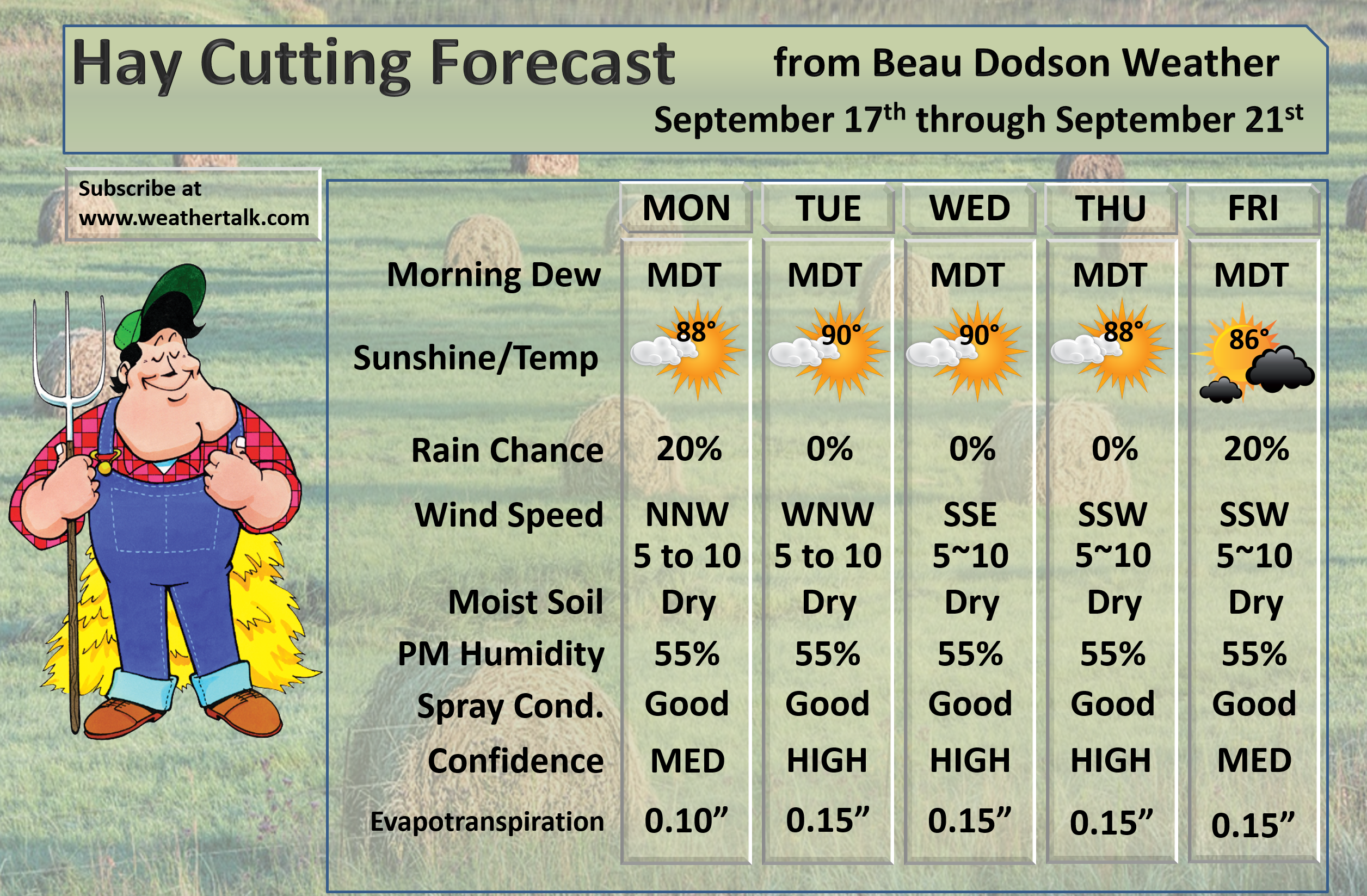
September 17, 2018
Monday Forecast Details
Forecast: Partly cloudy. Perhaps cloudy over the Pennyrile area of western Kentucky. An isolated shower or thunderstorm possible near Poplar Bluff, Missouri, and then over mainly the Pennyrile area of western Kentucky. Most areas should remain dry.
Temperatures: MO ~ 86 to 88 IL ~ 86 to 88 KY ~ 86 to 88 (84 to 86 where clouds are thicker) TN ~ 86 to 88
What is the chance of precipitation? MO ~ 10% IL ~ 10% KY ~ 20% TN ~ 10%
Coverage of precipitation: None to isolated.
Wind: Northwest winds at 5 to 10 mph
What impacts are anticipated from the weather? Most likely none. Isolated wet roadways and lightning. Most areas will remain dry.
My confidence in the forecast verifying: High
Is severe weather expected? No
The NWS defines severe weather as 58 mph wind or great, 1″ hail or larger, and/or tornadoes
Should I cancel my outdoor plans? No
UV Index: 8 to 10 High
Sunrise: 6:39 AM
Monday Night Forecast Details:
Forecast: Partly cloudy. Mild. Patchy fog again possible. An isolated shower or thunderstorm near Poplar Bluff, Missouri, and over the Pennyrile area of western Kentucky.
Temperatures: MO ~ 65 to 70 IL ~ 65 to 70 KY ~ 65 to 70 TN ~ 65 to 70
What is the chance of precipitation? MO ~ 0% IL ~ 0% KY ~ 10% TN ~ 0%
Coverage of precipitation: None
Wind: Light and variable winds
What impacts are anticipated from the weather? Perhaps patchy fog reducing visibility.
My confidence in the forecast verifying: High
Is severe weather expected? No
The NWS defines severe weather as 58 mph wind or great, 1″ hail or larger, and/or tornadoes
Should I cancel my outdoor plans? No
Sunset: 7:00 PM
Moonrise: 2:35 PM First Quarter
Moonset: 12:01 AM
September 18, 2018
Tuesday Forecast Details
Forecast: Mostly sunny. A few clouds. Hot and humid.
Temperatures: MO ~ 88 to 92 IL ~ 86 to 92 KY ~ 88 to 92 TN ~ 88 to 92
What is the chance of precipitation? MO ~ 10% IL ~ 10% KY ~ 10% TN ~ 5%
Coverage of precipitation: Isolated to none.
Wind: Southwest at 5 to 10 mph
What impacts are anticipated from the weather? Most locations will have no impacts from the weather.
My confidence in the forecast verifying: High
Is severe weather expected? No
The NWS defines severe weather as 58 mph wind or great, 1″ hail or larger, and/or tornadoes
Should I cancel my outdoor plans? No
UV Index: 9 to 10 High
Sunrise: 6:40AM
Tuesday Night Forecast Details:
Forecast: Mostly clear. Mild. Patchy fog possible.
Temperatures: MO ~ 66 to 70 IL ~ 66 to 70 KY ~ 66 to 70 TN ~ 66 to 70
What is the chance of precipitation? MO ~ 0% IL ~ 0% KY ~ 0% TN ~ 0%
Coverage of precipitation: None
Wind: Light winds
What impacts are anticipated from the weather? Perhaps patchy fog reducing visibility.
My confidence in the forecast verifying: High
Is severe weather expected? No
The NWS defines severe weather as 58 mph wind or great, 1″ hail or larger, and/or tornadoes
Should I cancel my outdoor plans? No
Sunset: 6:58 PM
Moonrise: 3:23 PM Waxing Gibbous
Moonset: 12:38 AM
September 19, 2018
Wednesday Forecast Details
Forecast: Mostly sunny and hot. Humid. A few passing clouds.
Temperatures: MO ~ 88 to 92 IL ~ 88 to 92 KY ~ 88 to 92 TN ~ 88 to 92
What is the chance of precipitation? MO ~ 0% IL ~ 0% KY ~ 0% TN ~ 0%
Coverage of precipitation: None
Wind: South and southeast at 4 to 8 mph
What impacts are anticipated from the weather? None
My confidence in the forecast verifying: High
Is severe weather expected? No
The NWS defines severe weather as 58 mph wind or great, 1″ hail or larger, and/or tornadoes
Should I cancel my outdoor plans? No
UV Index: 8 to 10 High
Sunrise: 6:41 AM
Wednesday Night Forecast Details:
Forecast: Mostly clear. Mild. Patchy fog again possible.
Temperatures: MO ~ 66 to 70 IL ~ 66 to 70 KY ~ 66 to 70 TN ~ 66 to 70
What is the chance of precipitation? MO ~ 0% IL ~ 0% KY ~ 0% TN ~ 0%
Coverage of precipitation: None
Wind: South at 5 mph
What impacts are anticipated from the weather? Perhaps patchy fog reducing visibility.
My confidence in the forecast verifying: High
Is severe weather expected? No
The NWS defines severe weather as 58 mph wind or great, 1″ hail or larger, and/or tornadoes
Should I cancel my outdoor plans? No
Sunset: 6:57 PM
Moonrise: 4:08 PM Waxing Gibbous
Moonset: 1:27 AM
September 20, 2018
Thursday Forecast Details
Forecast: Partly sunny and warm.
Temperatures: MO ~ 88 to 92 IL ~ 88 to 92 KY ~ 88 to 92 TN ~ 88 to 92
What is the chance of precipitation? MO ~ 5% IL ~ 5% KY ~ 5% TN ~ 5%
Coverage of precipitation: Most likely none
Wind: Southeast becoming south and southwest at 6 to 12 mph
What impacts are anticipated from the weather? None
My confidence in the forecast verifying: High
Is severe weather expected? No
The NWS defines severe weather as 58 mph wind or great, 1″ hail or larger, and/or tornadoes
Should I cancel my outdoor plans? No
UV Index: 8 to 19 High
Sunrise: 6:42 AM
Thursday Night Forecast Details:
Forecast: Some increase in clouds. A slight chance of a late night shower. Most likely we will remain dry.
Temperatures: MO ~ 68 to 72 IL ~ 68 to 72 KY ~ 68 to 72 TN ~ 68 to 72
What is the chance of precipitation? MO ~ 0% IL ~ 0% KY ~ 0% TN ~ 0%
Coverage of precipitation: Most likely none
Wind: South and southwest at 7 to 14 mph
What impacts are anticipated from the weather? Most likely none
My confidence in the forecast verifying: Medium
Is severe weather expected? No
The NWS defines severe weather as 58 mph wind or great, 1″ hail or larger, and/or tornadoes
Should I cancel my outdoor plans? No
Sunset: 6:55 PM
Moonrise: 4:48 PM Waxing Gibbous
Moonset: 2:20 AM
September 21, 2018
Friday Forecast Details
Forecast: Some clouds. A chance of showers and thunderstorms.
Temperatures: MO ~ 85 to 90 IL ~ 85 to 90 KY ~ 85 to 90 TN ~ 85 to 90
What is the chance of precipitation? MO ~ 40% to 50% IL ~ 40% to 50% KY ~ 30% to 40% TN ~ 30% to 40%
Coverage of precipitation: Scattered
Wind: South and southwest winds at 5 to 10 mph with gusts to 16 mph
What impacts are anticipated from the weather? Wet roadways. Lightning.
My confidence in the forecast verifying: Medium
Is severe weather expected? Unlikely
The NWS defines severe weather as 58 mph wind or great, 1″ hail or larger, and/or tornadoes
Should I cancel my outdoor plans? Monitor updates
UV Index: 5 to 6 Medium
Sunrise: 6:42 AM
Friday Night Forecast Details:
Forecast: Mostly cloudy. Showers and thunderstorms possible.
Temperatures: MO ~ 66 to 68 IL ~ 66 to 68 KY ~ 66 to 68 TN ~ 66 to 68
What is the chance of precipitation? MO ~ 40% IL ~ 40% KY ~ 40% TN ~ 40%
Coverage of precipitation: Scattered
Wind: Southwest at 5 to 10 mph
What impacts are anticipated from the weather? Wet roadways. Lightning.
My confidence in the forecast verifying: Medium
Is severe weather expected? Unlikely
The NWS defines severe weather as 58 mph wind or great, 1″ hail or larger, and/or tornadoes
Should I cancel my outdoor plans? Have a plan B and monitor updates
Sunset: 6:54 PM
Moonrise: 5:25 PM Waxing Gibbous
Moonset: 3:14 AM
September 22, 2018
Saturday Forecast Details
Forecast: Mostly cloudy. A chance of showers and thunderstorms.
Temperatures: MO ~ 78 to 84 IL ~ 78 to 84 KY ~ 78 to 84 TN ~ 78 to 84
What is the chance of precipitation? MO ~ 40% to 50% IL ~ 40% to 50% KY ~ 40% to 50% TN ~ 40% to 50%
Coverage of precipitation: Scattered to perhaps numerous
Wind: Northeast and east at 5 to 10 mph with gusts to 15 mph
What impacts are anticipated from the weather? Wet roadways and lightning.
My confidence in the forecast verifying: Medium
Is severe weather expected? Unlikely
The NWS defines severe weather as 58 mph wind or great, 1″ hail or larger, and/or tornadoes
Should I cancel my outdoor plans? Have a plan B and monitor updates
UV Index: 3 to 5 Low to medium
Sunrise: 6:43 AM
Saturday Night Forecast Details:
Forecast: Mostly cloudy. Showers and thunderstorms again possible.
Temperatures: MO ~ 60 to 65 IL ~ 60 to 65 KY ~ 60 to 65 TN ~ 60 to 65
What is the chance of precipitation? MO ~ 40% IL ~ 40% KY ~ 40% TN ~ 40%
Coverage of precipitation: Scattered
Wind: East at 5 to 10 mph
What impacts are anticipated from the weather? Wet roadways. Lightning.
My confidence in the forecast verifying: Medium
Is severe weather expected? Unlikely
The NWS defines severe weather as 58 mph wind or great, 1″ hail or larger, and/or tornadoes
Should I cancel my outdoor plans? Have a plan B and monitor updates
Sunset: 6:52 PM
Moonrise: 5:55 PM Waxing Gibbous
Moonset: 4:14 AM
September 23, 2018
Sunday Forecast Details
Forecast: Mostly cloudy. A chance of showers and thunderstorms.
Temperatures: MO ~ 76 to 82 IL ~ 76 to 82 KY ~ 76 to 82 TN ~ 76 to 82
What is the chance of precipitation? MO ~ 40% to 50% IL ~ 40% to 50% KY ~ 40% to 50% TN ~ 40% to 50%
Coverage of precipitation: Scattered to perhaps numerous
Wind: South and southeast at 5 to 10 mph
What impacts are anticipated from the weather? Wet roadways and lightning.
My confidence in the forecast verifying: Medium
Is severe weather expected? Unlikely
The NWS defines severe weather as 58 mph wind or great, 1″ hail or larger, and/or tornadoes
Should I cancel my outdoor plans? Have a plan B and monitor updates
UV Index: 3 to 5 Low to medium
Sunrise: 6:44 AM
Sunday Night Forecast Details:
Forecast: Mostly cloudy. Showers and thunderstorms again possible.
Temperatures: MO ~ 60 to 65 IL ~ 60 to 65 KY ~ 60 to 65 TN ~ 60 to 65
What is the chance of precipitation? MO ~ 40% IL ~ 40% KY ~ 40% TN ~ 40%
Coverage of precipitation: Scattered
Wind: Southwest at 5 to 10 mph
What impacts are anticipated from the weather? Wet roadways. Lightning.
My confidence in the forecast verifying: Medium
Is severe weather expected? Unlikely
The NWS defines severe weather as 58 mph wind or great, 1″ hail or larger, and/or tornadoes
Should I cancel my outdoor plans? Have a plan B and monitor updates
Sunset: 6:51 PM
Moonrise: 6:30 PM Waxing Gibbous
Moonset: 5:08 AM
September 24, 2018
Monday Forecast Details
Forecast: Partly sunny. A chance of widely scattered showers and thunderstorms.
Temperatures: MO ~ 76 to 82 IL ~ 76 to 82 KY ~ 76 to 82 TN ~ 76 to 82
What is the chance of precipitation? MO ~ 30% IL ~ 30% KY ~ 30% TN ~ 30%
Coverage of precipitation: Widely scattered
Wind: West at 5 to 10 mph
What impacts are anticipated from the weather? Wet roadways and lightning.
My confidence in the forecast verifying: LOW
Is severe weather expected? No
The NWS defines severe weather as 58 mph wind or great, 1″ hail or larger, and/or tornadoes
Should I cancel my outdoor plans? No, but monitor updates
UV Index: 6 to 8 Medium to high
Sunrise: 6:45 AM
Monday Night Forecast Details:
Forecast: Partly cloudy. A chance of a shower or thunderstorm.
Temperatures: MO ~ 60 to 65 IL ~ 60 to 65 KY ~ 60 to 65 TN ~ 60 to 65
What is the chance of precipitation? MO ~ 20% IL ~ 20% KY ~ 20% TN ~ 20%
Coverage of precipitation: Widely scattered
Wind: West at 5 to 10 mph
What impacts are anticipated from the weather? Wet roadways. Lightning.
My confidence in the forecast verifying: LOW
Is severe weather expected? Unlikely
The NWS defines severe weather as 58 mph wind or great, 1″ hail or larger, and/or tornadoes
Should I cancel my outdoor plans? No, but monitor updates
Sunset: 6:49 PM
Moonrise: 7:00 PM Full
Moonset: 6:06 AM
September 25, 2018
Tuesday Forecast Details
Forecast: Partly to mostly sunny.
Temperatures: MO ~ 76 to 82 IL ~ 76 to 82 KY ~ 76 to 82 TN ~ 76 to 82
What is the chance of precipitation? MO ~ 0% IL ~ 0% KY ~ 0% TN ~ 0%
Coverage of precipitation: None
Wind:
What impacts are anticipated from the weather? None
My confidence in the forecast verifying: LOW
Is severe weather expected? No
The NWS defines severe weather as 58 mph wind or great, 1″ hail or larger, and/or tornadoes
Should I cancel my outdoor plans? No
UV Index: 3 to 5 Low to medium
Sunrise: 6:46 AM
Tuesday Night Forecast Details:
Forecast: Mostly clear. Patchy fog.
Temperatures: MO ~ 60 to 65 IL ~ 60 to 65 KY ~ 60 to 65 TN ~ 60 to 65
What is the chance of precipitation? MO ~ 0% IL ~ 0% KY ~ 0% TN ~ 0%
Coverage of precipitation: None
Wind:
What impacts are anticipated from the weather? Lower visibility if fog forms.
My confidence in the forecast verifying: LOW
Is severe weather expected? No
The NWS defines severe weather as 58 mph wind or great, 1″ hail or larger, and/or tornadoes
Should I cancel my outdoor plans? No
Sunset: 6:47 PM
Moonrise: 7:30 PM Waning Gibbous
Moonset: 7:05 AM
Learn more about the UV index readings. Click here.

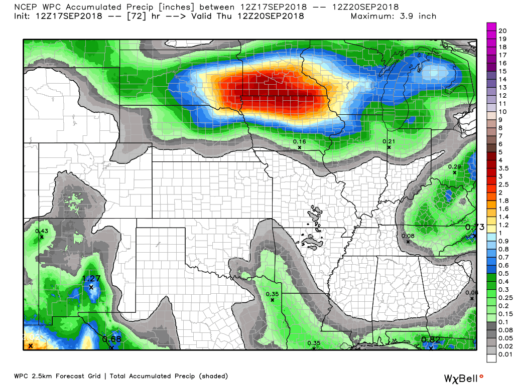
Here is the latest WPC/NOAA rainfall outlook.
This graphic takes us through Thursday morning
There could be some showers today across the Pennyrile area of western Kentucky and towards Poplar Bluff.
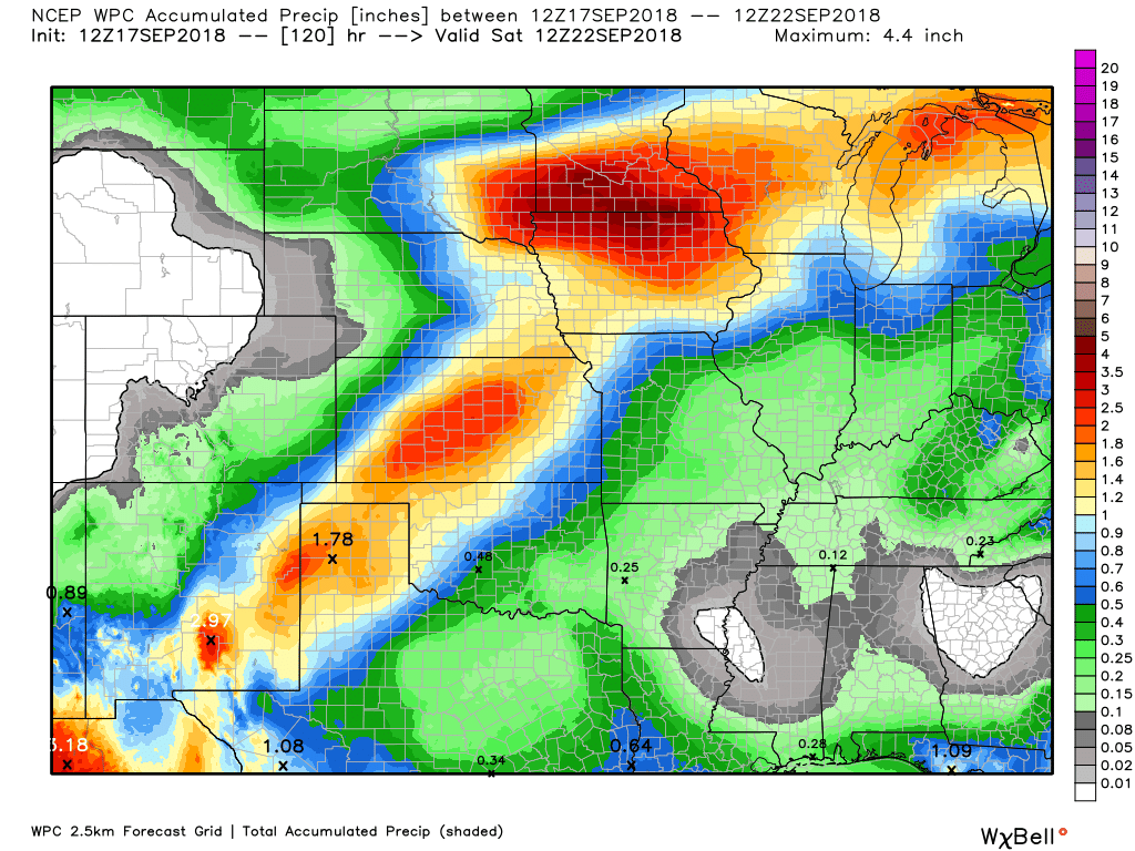
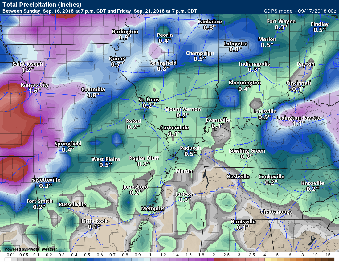
This graphic is now through Saturday morning. Rain chances should increase Friday into the weekend.
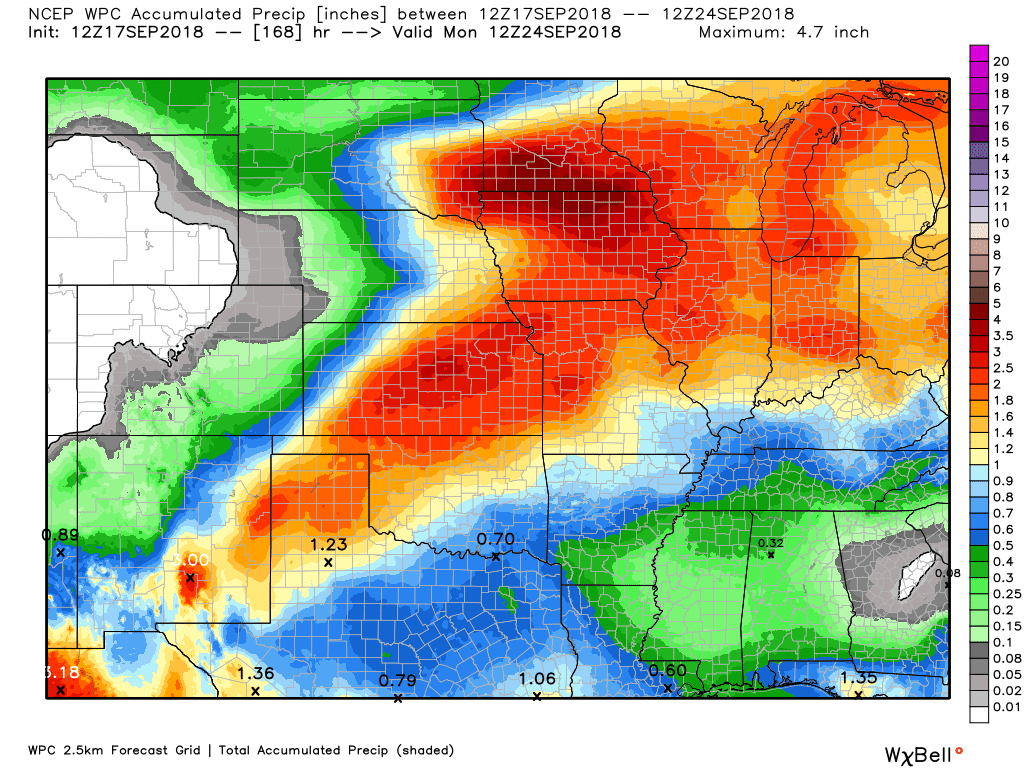
This next graphic is from now through next Monday morning. Perhaps some locally heavy downpours this coming weekend.
The GFS model guidance does not show as much rain. There remain some questions about rainfall totals.
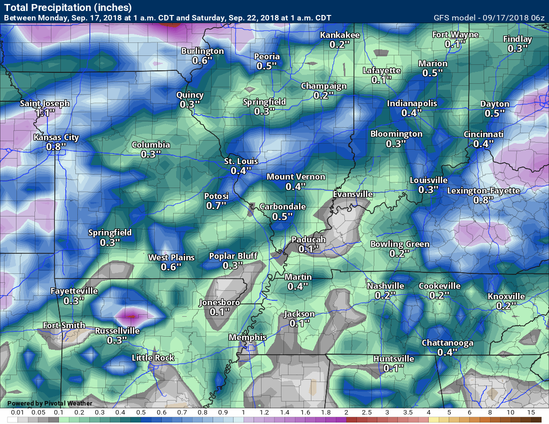
The Canadian model now through next Monday morning. Additional rain does fall after next Monday.

We offer interactive local city live radars and regional radars.
If a radar does not update then try another one. If a radar does not appear to be refreshing then hit Ctrl F5 on your keyboard.
You may also try restarting your browser. The local city view radars also have clickable warnings.
During the winter months, you can track snow and ice by clicking the winterize button on the local city view interactive radars.

Questions? Broken links? Other questions?
You may email me at beaudodson@usawx.com

The National Weather Service defines a severe thunderstorm as one that produces quarter size hail or larger, 58 mph winds or greater, and/or a tornado.
Today through Sunday: I can’t rule out lightning today. The main concern would be towards Poplar Bluff, Missouri and then over the Pennyrile area of western Kentucky. Otherwise, lightning chances will be low.
Thunderstorm chances increase Friday into the weekend. At this time, it appears the risk of severe thunderstorms will be low. Perhaps not zero. I am monitoring Sunday and Monday (September 23rd and 24th).
Interactive live weather radar page. Choose the city nearest your location. If one of the cities does not work then try a nearby one. Click here.
National map of weather watches and warnings. Click here.
Storm Prediction Center. Click here.
Weather Prediction Center. Click here.

Live lightning data: Click here.

Interactive GOES R satellite. Track clouds. Click here.

Here are the latest local river stage forecast numbers Click Here.
Here are the latest lake stage forecast numbers for Kentucky Lake and Lake Barkley Click Here.

- Warm/hot weather.
- Humid conditions.
- Weekend shower and thunderstorm chances are on the increase
It has been a nice weekend for the region! Friday into Sunday delivered plenty of sunshine and warm/hot temperatures. A bit on the muggy side, but overall, not too bad.
Our September has been quite warm. Here is the temperature anomaly map since September 1st. In other words, how warm or cool has it been?

As you can see, we are blanketed in red colors. Warmer than normal temperatures.
The coming days will deliver more of the same. Warm and humid. Highs will be in the upper 80’s to near 90 degrees. Now, keep in mind, portions of the region will have clouds today. Mainly portions of southern Illinois and western Kentucky/northwest Tennessee. This will be because of Florence. The clouds are moving E/NE towards the W/SW. Temperatures will be a bit cooler in the cloud zone.
Live satellite images (you can refresh this satellite page to see the latest imagery)
A few showers are possible today in response to a bit of lift. The chances will be low-end and will be centered on the Pennyrile area of western Kentucky. That would includees areas from Evansville, Indiana, towards Cadiz, Kentucky. From there eastward. Also, a chance of a shower or thunderstorm near the Poplar Bluff, Missouri, area.
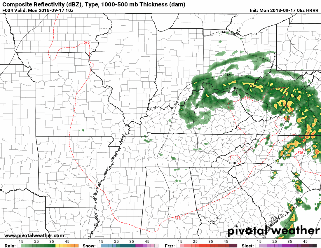
Here is the Hrrr future-cast radar. What radar might look like today.
Time stamp upper left. 12z is 7 AM. 18z is 1 PM. 00z is 7 PM.
Maybe a few showers today, but most areas will remain dry.
The next weather-maker will arrive Friday, Saturday, and Sunday.
A cold front will near the region from the north. The speed of this cold front is still in question.
Rain shower and thunderstorm chances are forecast to increase Friday into the weekend. Some locally heavy rain will also be possible.
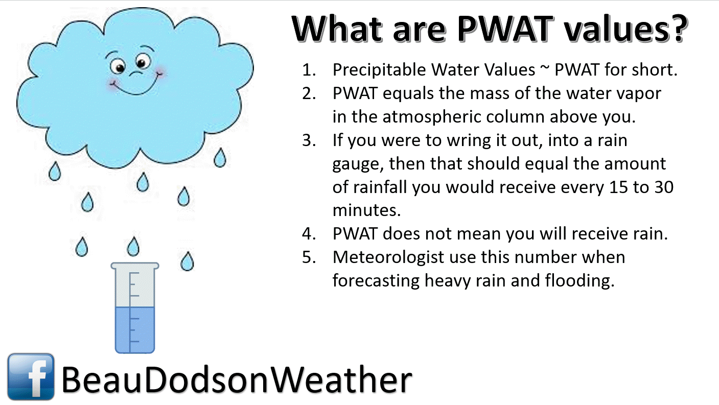
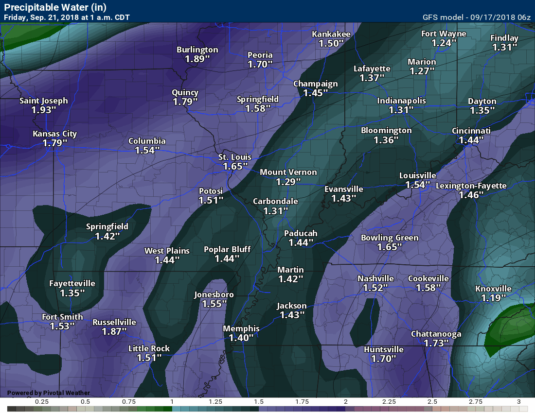
PWAT values, a measure of moisture in the whole atmosphere, will be on the high side. That equals locally heavy rain chances.
Here is the PWAT animation.
Time-stamp upper left.
Anything above 1.7 is fairly high. Anything about 2″ is very high.
Here is the Wednesday weather map. You can see that cold front to our north. It will sag southward by Friday and Saturday.

Here is the map by Saturday morning.
You can see the cold front sagging into our region. This will become the focus of rain chances Friday into early next week.

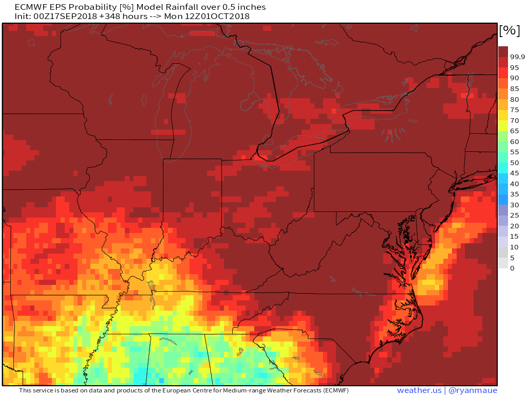
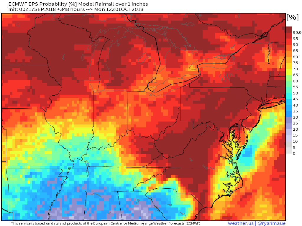
Let’s look at some percent of rainfall chances.
What is the % chance of at least 0.50″ of rain falling between now and next Monday morning?
What is the % chance of one inch or more of rain falling between now and next Monday morning?
What is the % chance of two or more inches of rain falling between now and next Monday morning?
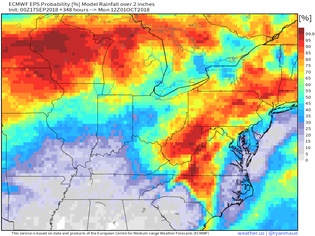
Decent rain chances as we move towards the end of the week.
Want information on the tropics?
Please visit the National Hurricane Center’s website for the latest information on Florence.
The National Hurricane Center will be issuing forecasts on this system.
Here is their link CLICK HERE
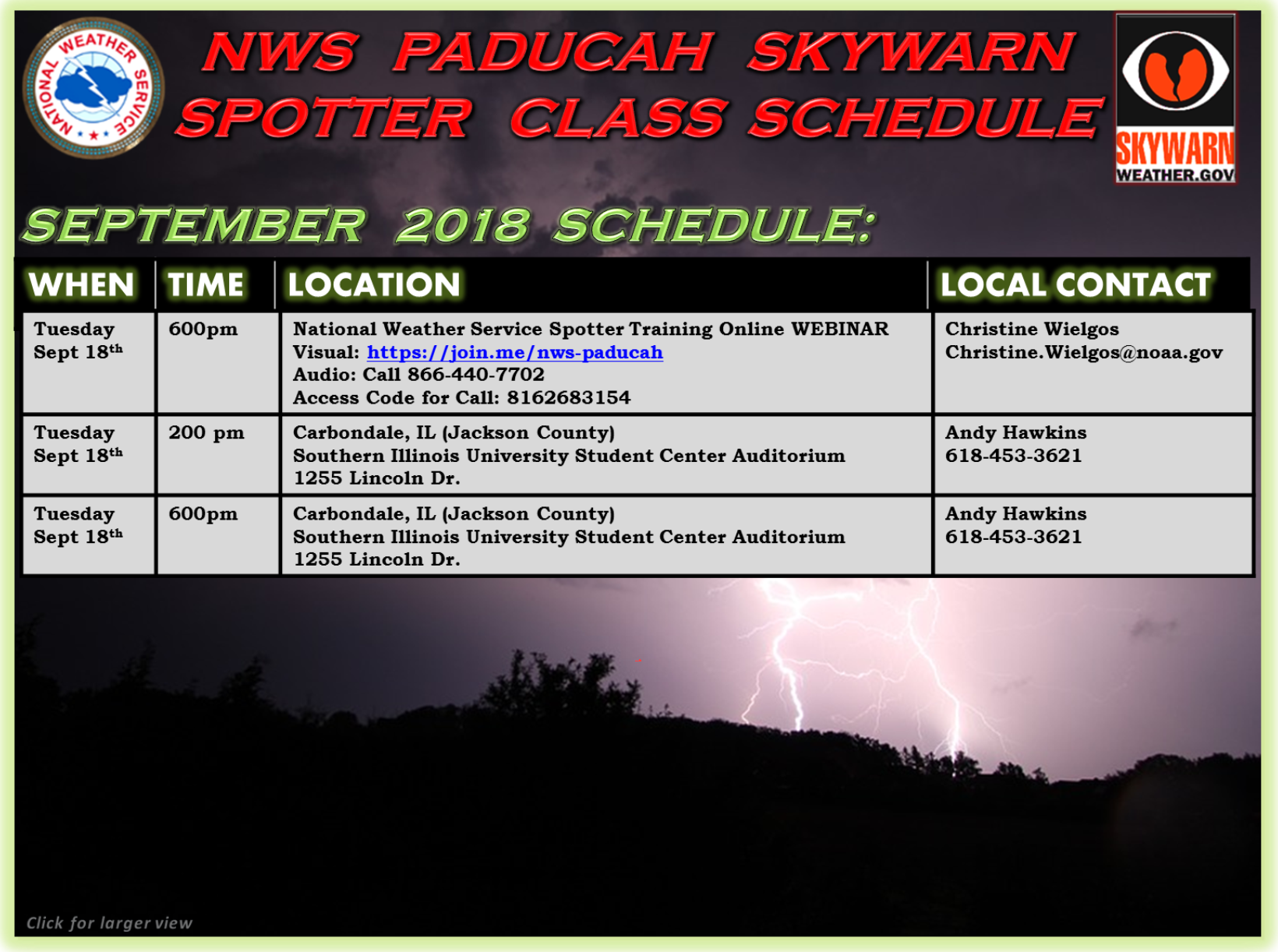
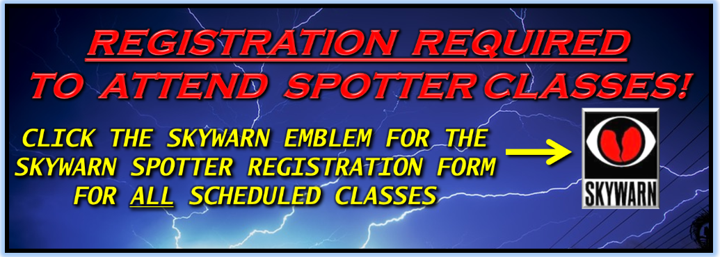
Spotter classes
![]()
Here is the preliminary fall outlook from the long range meteorology team.
Click to enlarge this graphic.
.
![]()
The September forecast has been updated.
![]()

I bring these to you from the BAMwx team. They are excellent long-range forecasters.
Remember, long-range outlooks are a bit of skill, understanding weather patterns, and luck combined. It is not an exact science.

This product is for subscribers.
Subscribe at www.weathertalk.com
Subscriber graphics can be viewed on this page CLICK HERE

This product is for subscribers.

Subscriber graphics can be viewed on this page CLICK HERE
![]()
.
First glance at fall!
Preliminary October precipitation outlook
Here is the preliminary November temperature and precipitation outlook
Preliminary November temperature outlook
Preliminary November precipitation outlook
.
![]()

![]()

A new weather podcast is now available! Weather Geeks (which you might remember is on The Weather Channel each Sunday)
To learn more visit their website. Click here.
![]()

WeatherBrains Episode 660
Joining us once again for this episode of WeatherBrains is Dr. Marshall Shepherd from the University of Georgia. He needs almost no introduction to our audience as a former President of the AMS and the host of The Weather Channel’s WxGeeks show. Dr. Marshall Shepherd, welcome back to WeatherBrains! Dr. Shepherd was a guest panelist on episode 572 and guest WeatherBrain on episode 628.
Other discussions in this weekly podcast include topics like:
- Extremes: 111 at Death Valley, CA. & Ocotillo Wells, CA, and 21 at Stanley, ID
- Three hurricanes in the Atlantic
- Florence threatening landfall in the Carolinas as major hurricane
- Isaac to move into Caribbean
- Helene to stay at sea
- Another storm to affect Hawaii (Olivia)
- Astronomy Outlook with Tony Rice
- and more!
Link to web-site https://weatherbrains.com/
Previous episodes can be viewed by clicking here.

We offer interactive local city live radars and regional radars. If a radar does not update then try another one. If a radar does not appear to be refreshing then hit Ctrl F5. You may also try restarting your browser.
The local city view radars also have clickable warnings.
During the winter months, you can track snow and ice by clicking the winterize button on the local city view interactive radars.
You may email me at beaudodson@usawx.com
Find me on Facebook!

Find me on Twitter!

Did you know that a portion of your monthly subscription helps support local charity projects?
You can learn more about those projects by visiting the Shadow Angel Foundation website and the Beau Dodson News website.

I encourage subscribers to use the app vs regular text messaging. We have found text messaging to be delayed during severe weather. The app typically will receive the messages instantly. I recommend people have three to four methods of receiving their severe weather information.
Remember, my app and text alerts are hand typed and not computer generated. You are being given personal attention during significant weather events.
