

.
You must have a Weather Talk subscription ($3 a month) to view the videos.
Videos are posted on the www.weathertalk.com website. Once there, click the Beau Video-Cast tab. Long Range Video Update
If you believe you missed a video then you can also click the LIVE FEED link on the Weather Talk website. You will find the most recent and previous seven days worth of links on that page.
I can app/text you the videos, as well. Make sure you have text option FOUR turned on. That would be the Weather Extra text option. Sign up for the app/text messages, videos, and more at www.beaudodsonweather.com
.

.
This forecast update covers southern Illinois, southeast Missouri, western Kentucky. and extreme northwest Tennessee.
.
September 15, 2017
Friday Night Forecast Details:
Forecast: Mostly clear. Patchy dense fog.
Temperatures: MO ~ 64 to 68 IL ~ 62 to 66 KY ~ 64 to 68 TN ~ 64 to 68
Winds: South and southeast winds at 5 mph
What impacts are anticipated from the weather? Lower visibility in fog
My confidence in the forecast verifying: High
Is severe weather expected? No
The NWS defines severe weather as 58 mph winds or great, 1″ hail or larger, and/or tornadoes
What is the chance of precipitation? MO ~ 0% IL ~ 0% KY ~ 0% TN ~ 0%
Coverage of precipitation: None
Should I cancel my outdoor plans? No
.
September 16, 2017
Saturday Forecast Details
Forecast: Patchy morning dense fog. Mostly sunny (after the fog mixes out). Warm and a bit humid.
Temperatures: MO ~ 85 to 90 IL ~ 85 to 90 KY ~ 85 to 90 TN ~ 85 to 90
Winds: South winds at 5 to 10 mph
What impacts are anticipated from the weather? Most likely none.
My confidence in the forecast verifying: High
Is severe weather expected? No
The NWS defines severe weather as 58 mph winds or great, 1″ hail or larger, and/or tornadoes
What is the chance of precipitation? MO ~ 0% IL ~ 0% KY ~ 0% TN ~ 0%
Coverage of precipitation: None anticipated
Should I cancel my outdoor plans? No
.
Saturday Night Forecast Details:
Forecast: Mostly clear. Patchy fog possible. Becoming partly cloudy over southeast Missouri and southwest Illinois.
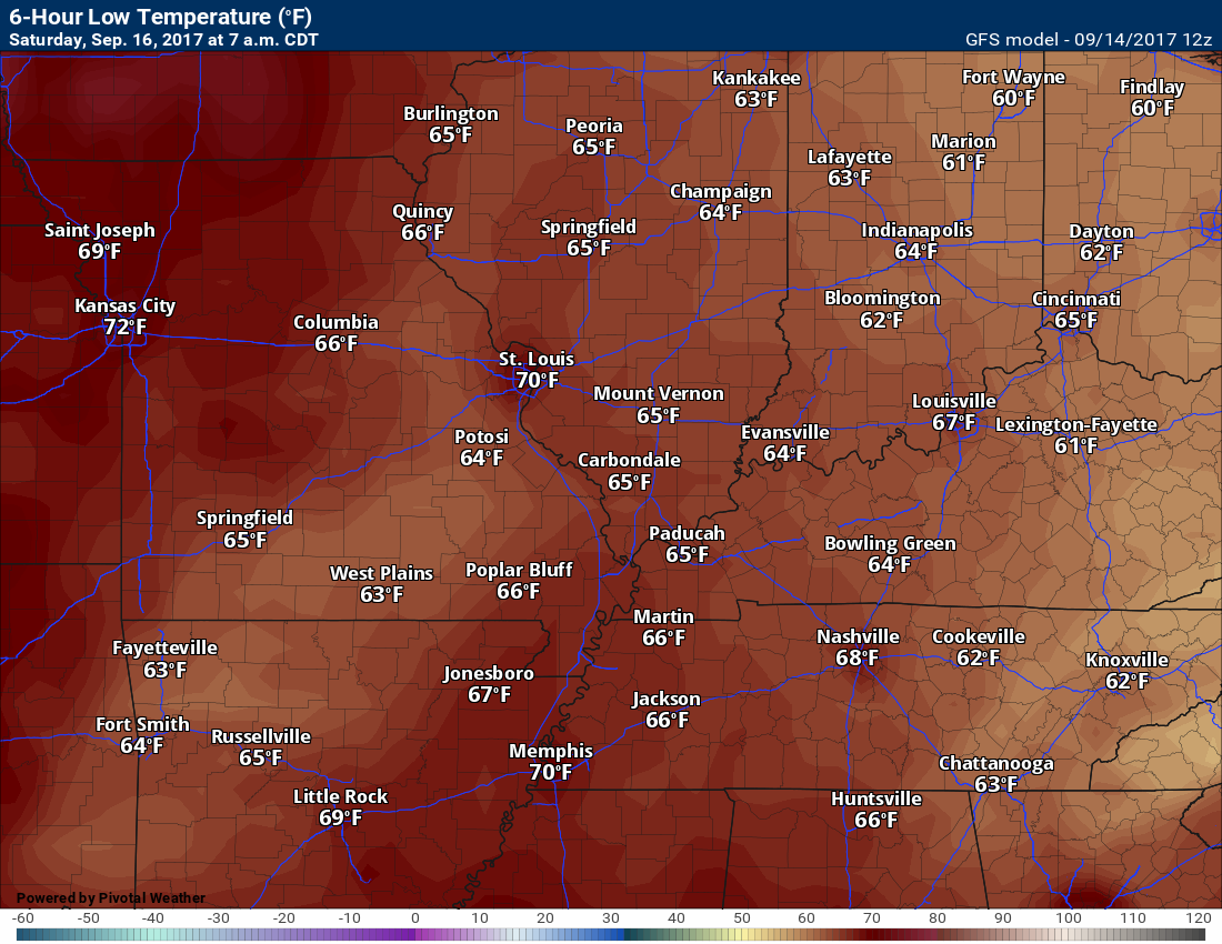
Temperatures: MO ~ 64 to 68 IL ~ 64 to 68 KY ~ 64 to 68 TN ~ 64 to 68
What impacts are anticipated from the weather? Lower visibility if fog forms
My confidence in the forecast verifying: High
Is severe weather expected? No
The NWS defines severe weather as 58 mph winds or great, 1″ hail or larger, and/or tornadoes
What is the chance of precipitation? MO ~ 10% IL ~ 0% KY ~ 0% TN ~ 0%
Coverage of precipitation: None
Should I cancel my outdoor plans? No
.
September 17, 2017
Sunday Forecast Details
Forecast: Patchy morning fog. Partly to mostly sunny. A few afternoon cumulus clouds with a 20% to 30% of a thunderstorm for southeast Missouri and southwest Illinois. A 10% chance elsewhere. Warm and a bit more humid.
Temperatures: MO ~ 85 to 90 IL ~ 85 to 90 KY ~ 85 to 90 TN ~ 85 to 90
Winds: South winds at 5 to 10 mph
What impacts are anticipated from the weather? Most likely none. A few areas may have wet roadways and lightning (mainly over SE MO/SW IL)
My confidence in the forecast verifying: Medium
Is severe weather expected? No
The NWS defines severe weather as 58 mph winds or great, 1″ hail or larger, and/or tornadoes
What is the chance of precipitation? MO ~ 30% IL ~ 30% KY ~ 10% TN ~ 10%
Coverage of precipitation: Much of the region will remain dry. Scattered storms for southeast Missouri and southwest Illinois. Lesser chances elsewhere.
Should I cancel my outdoor plans? No, but perhaps check radars.
.
Sunday Night Forecast Details:
Forecast: A few clouds. A 20% of an evening thunderstorm. Patchy fog possible.
Temperatures: MO ~ 65 to 70 IL ~ 65 to 70 KY ~ 65 to 70 TN ~ 65 to 70
What impacts are anticipated from the weather? Isolated wet roads and lightning.
My confidence in the forecast verifying: High
Is severe weather expected? No
The NWS defines severe weather as 58 mph winds or great, 1″ hail or larger, and/or tornadoes
What is the chance of precipitation? MO ~ 20% IL ~ 20% KY ~ 20% TN ~ 20%
Coverage of precipitation: Small chance of an isolated evening storm.
Should I cancel my outdoor plans? No
.
September 18, 2017
Monday Forecast Details
Forecast: Partly sunny. Warm and humid. A chance of a few thunderstorms.
Temperatures: MO ~ 85 to 88 IL ~ 85 to 88 KY ~ 85 to 88 TN ~ 85 to 88
Winds: Southwest winds at 5 to 10 mph
What impacts are anticipated from the weather? Wet roadways. Lightning.
My confidence in the forecast verifying: Medium
Is severe weather expected? No
The NWS defines severe weather as 58 mph winds or great, 1″ hail or larger, and/or tornadoes
What is the chance of precipitation? MO ~ 30% IL ~ 30% KY ~ 30% TN ~ 30%
Coverage of precipitation: Scattered
Should I cancel my outdoor plans? No, but monitor updates
.
Monday Night Forecast Details:
Forecast: Partly cloudy. A slight chance of a thunderstorm.
Temperatures: MO ~ 65 to 70 IL ~ 65 to 70 KY ~ 65 to 70 TN ~ 65 to 70
What impacts are anticipated from the weather? Wet roadways. Lightning
My confidence in the forecast verifying: Medium
Is severe weather expected? No
The NWS defines severe weather as 58 mph winds or great, 1″ hail or larger, and/or tornadoes
What is the chance of precipitation? MO ~ 20% IL ~ 20% KY ~ 20% TN ~ 20%
Coverage of precipitation: Isolated
Should I cancel my outdoor plans? No, but monitor updates
.
September 19, 2017
Tuesday Forecast Details
Forecast: Partly sunny. Warm and humid. A slight chance of a thunderstorm.
Temperatures: MO ~ 85 to 88 IL ~ 85 to 88 KY ~ 85 to 88 TN ~ 85 to 88
Winds: Calm to south winds at 5 to 10 mph
What impacts are anticipated from the weather? A chance of wet roadways and lightning.
My confidence in the forecast verifying: Low
Is severe weather expected? No
The NWS defines severe weather as 58 mph winds or great, 1″ hail or larger, and/or tornadoes
What is the chance of precipitation? MO ~ 20% IL ~ 20% KY ~ 20% TN ~ 20%
Coverage of precipitation: Isolated
Should I cancel my outdoor plans? No, but monitor updates
.
Tuesday Night Forecast Details:
Forecast: Partly cloudy. Warm. A slight chance of a thunderstorm.
Temperatures: MO ~ 65 to 70 IL ~ 65 to 70 KY ~ 65 to 70 TN ~ 65 to 70
What impacts are anticipated from the weather? Wet roadways. Lightning
My confidence in the forecast verifying: Low
Is severe weather expected? No
The NWS defines severe weather as 58 mph winds or great, 1″ hail or larger, and/or tornadoes
What is the chance of precipitation? MO ~ 20% IL ~ 20% KY ~ 20% TN ~ 20%
Coverage of precipitation: None to isolated
Should I cancel my outdoor plans? No, but monitor updates
.
September 20, 2017
Wednesday Forecast Details
Forecast: Partly sunny. Warm and humid. A chance of a thunderstorm.
Temperatures: MO ~ 85 to 88 IL ~ 85 to 88 KY ~ 85 to 88 TN ~ 85 to 88
Winds: South winds at 5 to 10 mph
What impacts are anticipated from the weather? A chance of wet roadways and lightning.
My confidence in the forecast verifying: Low
Is severe weather expected? No
The NWS defines severe weather as 58 mph winds or great, 1″ hail or larger, and/or tornadoes
What is the chance of precipitation? MO ~ 30% IL ~ 30% KY ~ 30% TN ~ 30%
Coverage of precipitation: Scattered
Should I cancel my outdoor plans? No, but monitor updates
.
Wednesday Night Forecast Details:
Forecast: Mostly cloudy. Warm. A chance of a thunderstorm.
Temperatures: MO ~ 65 to 70 IL ~ 65 to 70 KY ~ 65 to 70 TN ~ 65 to 70
What impacts are anticipated from the weather? Wet roadways. Lightning
My confidence in the forecast verifying: Low
Is severe weather expected? No
The NWS defines severe weather as 58 mph winds or great, 1″ hail or larger, and/or tornadoes
What is the chance of precipitation? MO ~ 30% IL ~ 30% KY ~ 30% TN ~ 30%
Coverage of precipitation: Scattered
Should I cancel my outdoor plans? No, but monitor updates
.

Don’t forget to check out the Southern Illinois Weather Observatory web-site for weather maps, tower cams, scanner feeds, radars, and much more! Click here
.

A severe thunderstorm is defined as a storm that produces quarter size hail or larger, 58 mph winds or greater, and/or a tornado. That is the official National Weather Service definition of a severe thunderstorm
Friday night through Wednesday: Severe weather is not anticipated.
.
Lightning is possible Sunday through Thursday. See the day by day details at the top of this post.
Lightning risk


Overview
Are there any weather concerns
- Above normal temperatures
- Thunderstorm chances early next week (low confidence)
Short range
Confidence level in the short range forecast is high
Nice weather can be expected for tonight into Saturday night. Warm. Decent camping weather. Perhaps a little humid.
Guidance is trying to paint isolated showers and thunderstorms on Sunday and Sunday night. My confidence on this part of the forecast is low. I did mention low end chances for precipitation, but believe, for the most part, the area will remain dry.
The best chance for Sunday storms should be over southeast Missouri and southwest Illinois. Lesser chances elsewhere.
Thunderstorm chances may increase a bit by Monday through Thursday. Weak disturbances will be passing through the area. When one of the pulses moves through our area there will be lift. That lift could pop a few showers and storms.
The greatest chance for rain should arrive towards Wednesday and Thursday. See the day to day details above.
As far as rainfall totals, if we have some thunderstorms then locally heavy rain would be possible. For the most, rain totals will range from 0.20″ to 0.50″. It is likely that many areas receive no measurable rain on Sunday through Tuesday night. Perhaps better coverage towards the middle/end of the work week.
TEMPERATURE FORECAST
Click images to enlarge
Low temperatures for Friday night
High temperatures for Saturday

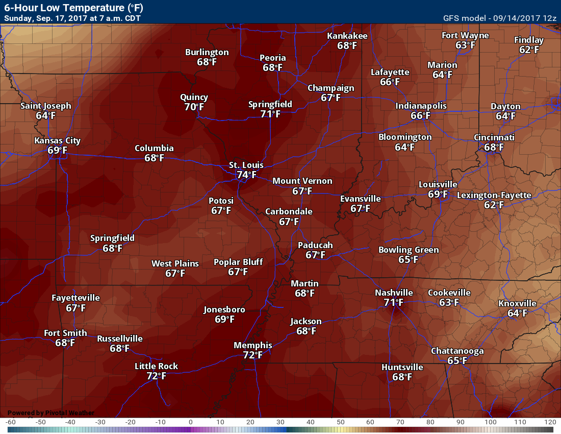
Saturday night low temperatures
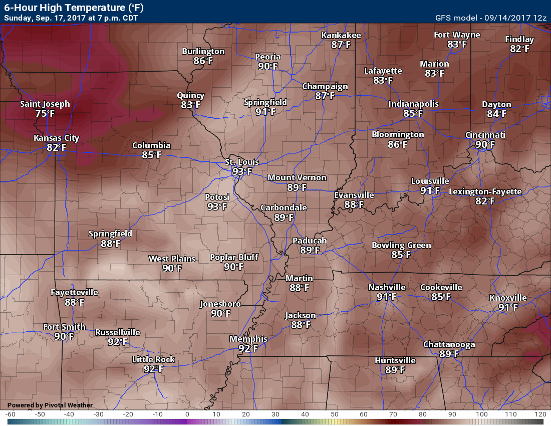
High temperatures for Sunday
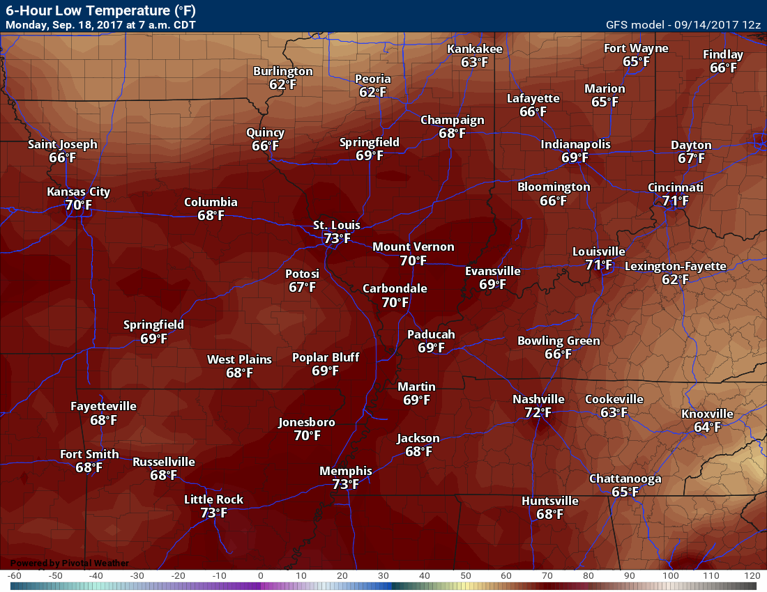
Sunday night low temperatures
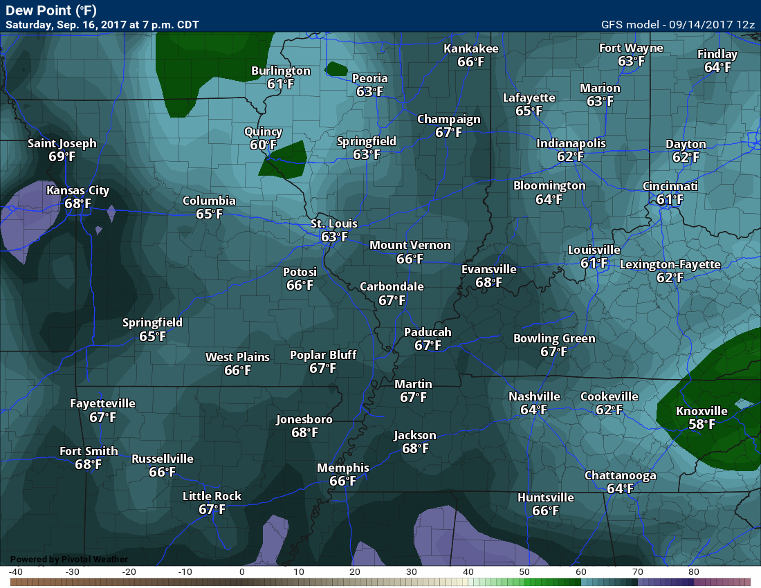
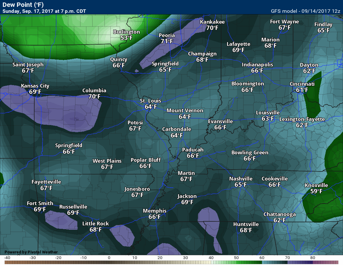
Dew point scale

Click images to enlarge
Dew points for Saturday
Dew points for Sunday
Long range
The bottom line is that we have at least some chance for scattered showers and thunderstorms starting Sunday night and continuing into next week. Confidence in totals and coverage is still rather low. That means that I am not sure how much rain we will receive. I have a chance for thunderstorms in the forecast. I will fine tune the forecast moving forward. I will monitor data trends.
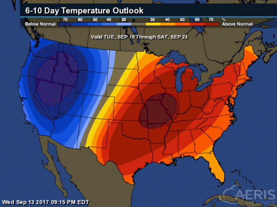
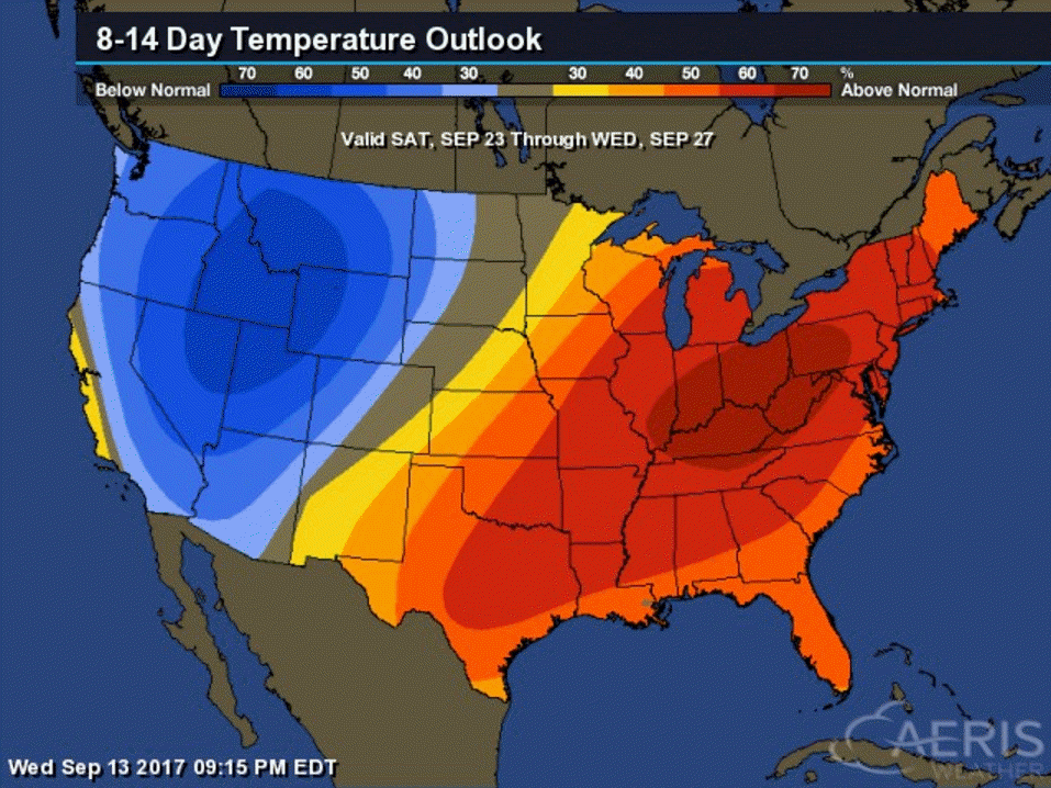
The six to ten and eight to fourteen day temperature outlooks are favoring above normal temperatures.
and
Eight to fourteen day outlook (see dates at top of image)
Click to enlarge
Tropics
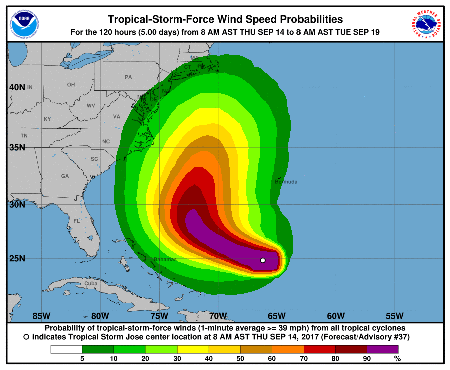
Three systems to monitor in the Atlantic.
Jose is still around and may brush the East Coast. Still questions on the eventual track. Two more systems way out in the Atlantic. One of them could impact the islands.
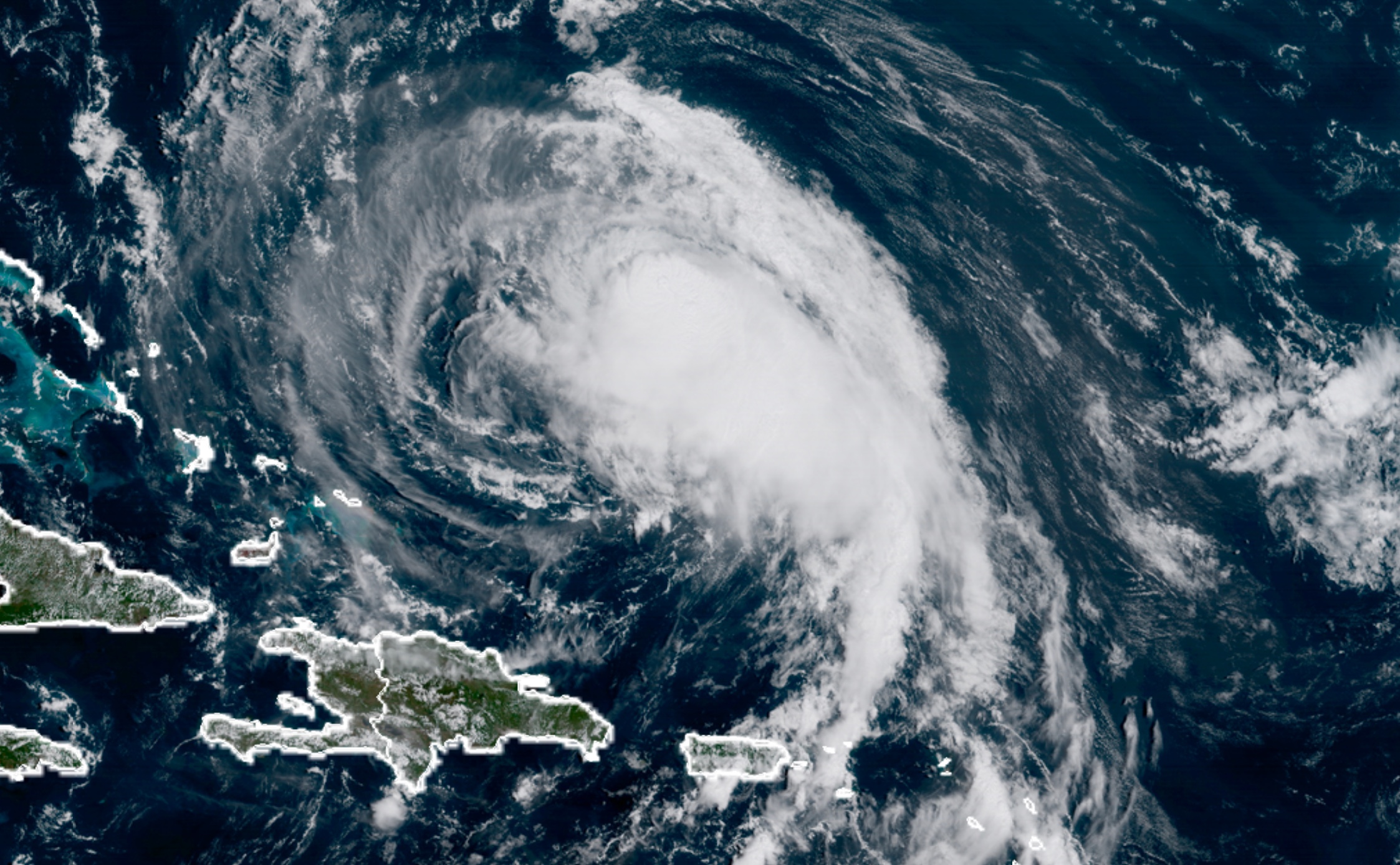
Here is Jose
Possible track
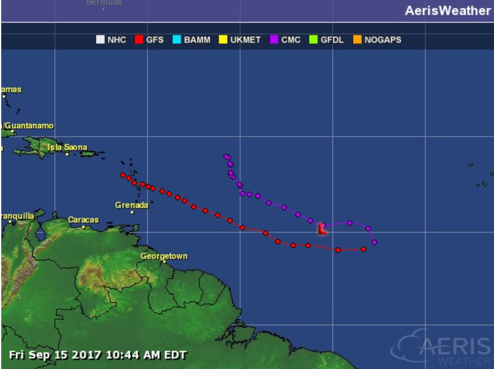
Of interest is disturbance 96L
Watching it closely.
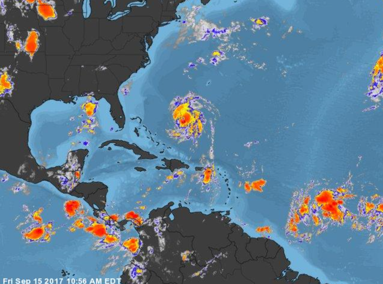
Satellite
96L is the cloud mass at the bottom right hand corner of the satellite image
Are you subscribing to the Weather Talk texts and videos?
We now have premiere videos for the short and long range forecasts! Make sure you have text option four turned on (green).
Sign up at www.beaudodsonweather.com
We also have an Apple and Android app (scroll down to bottom of the page for more information)

Were you aware that I have hired some help for long range videos? Short range videos, as well. An amazing team of meteorologists.
Click the link below to read more
http://cms.weathertalk.com/meet-the-team/
Weather Talk subscribers now have some of the best short and long range weather videos produced across the eastern United States.
.


We have regional radars and local city radars – if a radar does not update then try another one. Occasional browsers need their cache cleared. You may also try restarting your browser. That usually fixes the problem. Occasionally we do have a radar go down. That is why I have duplicates. Thus, if one fails then try another one.
During the winter you can track snow and ice by clicking the winterize button on the local city view interactive radars.
If you have any problems then please send me an email beaudodson@usawx.com
Interactive Weather Radar Page. Choose the city nearest your location: Click this link
National interactive radar: Click this link.
Local interactive city radars include St Louis, Mt Vernon, Evansville, Poplar Bluff, Cape Girardeau, Marion, Paducah, Hopkinsville, Memphis, Nashville, Dyersburg, and all of eastern Kentucky. These are interactive radars. Local city radars – click here
The Beau Dodson Weather APP is ready for Apple and Android users. The purpose of this app is for me to deliver your app/text messages instantly. ATT and Verizon have not always been reliable when it comes to speed. The app allows instant delivery.
Some of you have asked if you can receive the texts on your phone and the app. The answer to that is, yes. The Android app will automatically allow that to happen. On the Apple app, however, you will need to go into your app and click settings. Make sure the green tab is OFF. Off means you will still receive the texts to your phone and the app. If you have any questions, then email me at beaudodson@usawx.com
The app is for text subscribers.
The direct download, for the Apple app, can be viewed here
https://itunes.apple.com/us/app/id1190136514
If you have not signed up for the texting service then you may do so at www.beaudodsonweather.com

The Android app is also ready.
Remember, the app’s are for www.weathertalk.com subscribers. The app allows your to receive the text messages faster than ATT and Verizon.
Here is the download link for the Android version Click Here

——————————————————–
If you have not signed up for the texts messages, then please do. Link www.beaudodsonweather.com
Your support helps with the following:

and


Who do you trust for your weather information and who holds them accountable?
I have studied weather in our region since the late 1970’s. I have 39 years of experience in observing our regions weather patterns. My degree is in Broadcast Meteorology and a Bachelor’s of Science.
My resume includes:
Member of the American Meteorological Society.
NOAA Weather-Ready Nation Ambassador.
Meteorologist for McCracken County Emergency Management. I served from 2005 through 2015.
Meteorologist for McCracken County Rescue. 2015 through current
I own and operate the Southern Illinois Weather Observatory.
I am the chief meteorologist for Weather Talk LLC. I am the owner of Weather Talk LLC.
I am also a business owner in western Kentucky.
Recipient of the Mark Trail Award, WPSD Six Who Make A Difference Award, Kentucky Colonel, and the Caesar J. Fiamma” Award from the American Red Cross.
In 2005 I helped open the largest American Cross shelter in U.S. history in Houston, Texas. I was deployed to help after Hurricane Katrina and Hurricane Rita. I was a shelter manager of one of the Houston, Texas shelter divisions.
In 2009 I was presented with the Kentucky Office of Highway Safety Award.
Recognized by the Kentucky House of Representatives for my service to the State of Kentucky leading up to several winter storms and severe weather outbreaks.
If you click on the image below you can read the Kentucky House of Representatives Resolution.

I am also President of the Shadow Angel Foundation which serves portions of western Kentucky and southern Illinois.
There is a lot of noise on the internet. A lot of weather maps are posted without explanation. Over time you should learn who to trust for your weather information.
My forecast philosophy is simple and straight forward.
- Communicate in simple terms
- To be as accurate as possible within a reasonable time frame before an event
- Interact with you on Twitter, Facebook, email, texts, and this blog
- Minimize the “hype” that you might see on some television stations or through other weather sources
- Push you towards utilizing wall-to-wall LOCAL TV coverage during severe weather events
Many of the graphics on this page are from www.weatherbell.com
WeatherBell is a great resource for weather model guidance.


You can sign up for my AWARE email by clicking here I typically send out AWARE emails before severe weather, winter storms, or other active weather situations. I do not email watches or warnings. The emails are a basic “heads up” concerning incoming weather conditions