

.
A Weather Talk subscription ($3 a month) is required to view the videos. This helps cover monthly costs (which can run between one and two thousand dollars).
Videos are posted on the www.weathertalk.com website. Once there, click the Beau Video-Cast tab. Long Range Video Update
If you believe you missed a video then you may check the LIVE FEED link on the Weather Talk website. You will find an archive of videos on that page.
You can also receive the videos via your Weather Talk app/text messages. Turn text option FOUR to the on position. The Weather Extra text option. Sign up for the app/text messages, videos, and more at www.beaudodsonweather.com
Your $3 a month helps cover the following monthly costs. These are my out of pocket expenses.

This forecast covers the counties in red. The counties in orange are covered by the forecast discussion further down in the blog.


.
October 31, 2017
Tuesday Night Forecast Details:
Forecast: Cloudy. Increasing chances of rain. Chilly. A few sleet pellets possible at the onset of the precipitation. No impact or concern. Cool.
Temperatures: MO ~ 36 to 44 IL ~ 35 to 40 KY ~ 34 to 40
Winds: Wind becoming southerly 6 to 12 mph.
What impacts are anticipated from the weather? Wet roadways.
My confidence in the forecast verifying: High
Is severe weather expected? No
The NWS defines severe weather as 58 mph wind or great, 1″ hail or larger, and/or tornadoes
What is the chance of precipitation? MO ~ 90% Bootheel and far SE MO. 60% northern parts of southeast MO IL ~ 70% extreme southern IL (southern seven counties) and 60% northern parts of southern Illinois KY ~ 90%
Coverage of precipitation: Increasing from the west/southwest. Scattered at first and then numerous.
Should I cancel my outdoor plans? No, but monitor updates. Evening showers are a possibility.
.
.
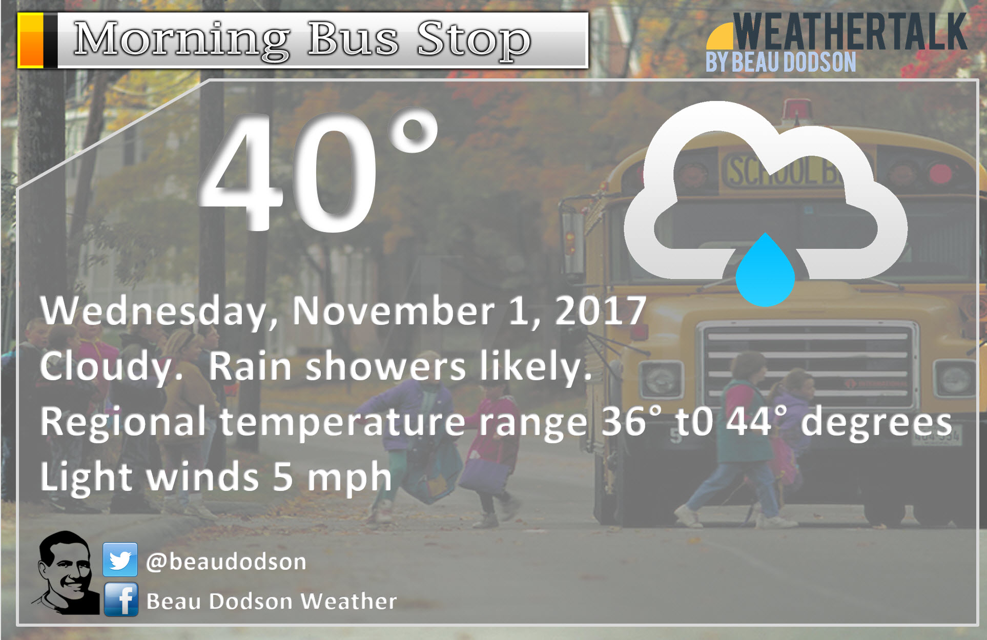
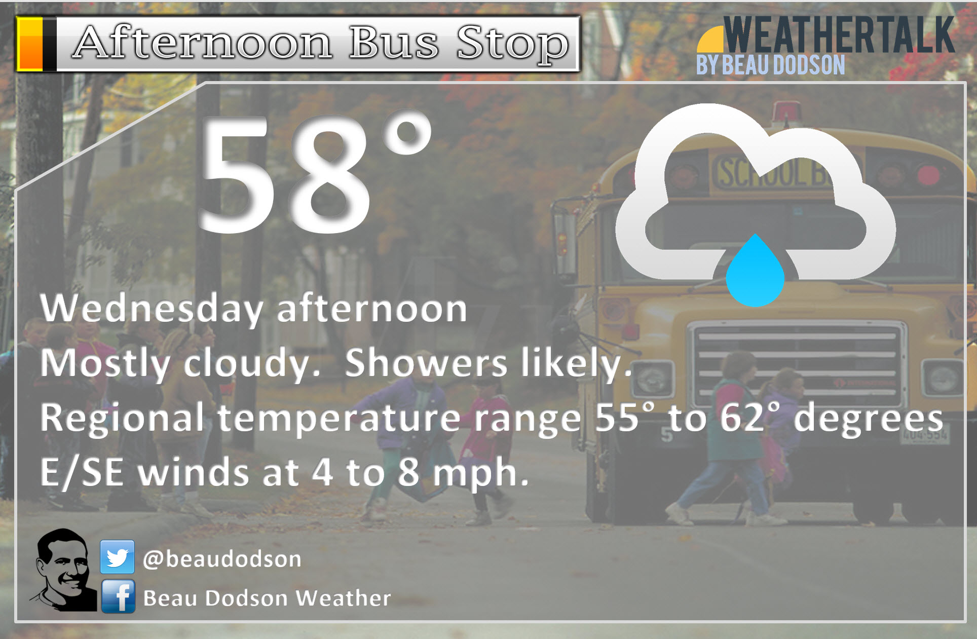
November 1, 2017
Wednesday Forecast Details
Forecast: Intervals of clouds. Numerous showers, especially during the morning hours. Scattered afternoon showers. The greatest coverage of rain will likely be over the southern half of the region. That would include the Missouri Bootheel into western Kentucky/Tennessee. As you travel further north and west the coverage may decrease.
Temperatures: MO ~ 55 to 60 IL ~ 55 to 60 KY ~ 55 to 60
Winds: Southeast wind at 5 to 10 mph. Gusts to 15 mph possible.
What impacts are anticipated from the weather? Wet roadways
My confidence in the forecast verifying: Medium
Is severe weather expected? No
The NWS defines severe weather as 58 mph wind or great, 1″ hail or larger, and/or tornadoes
Is freezing rain, sleet, or snow expected? No.
What is the chance of precipitation? MO ~ 60% IL ~ 60% KY ~ 70%
Coverage of precipitation: Numerous in the morning and then scattered afternoon. Greatest coverage southern half of the region.
Should I cancel my outdoor plans? Have a plan B
.
Wednesday Night Forecast Details:
Forecast: Showers possible. Temperatures rising through the night. Gusty winds. Low temperatures will be early in the evening.
Temperatures: MO ~ 44 to 48 and then rising well into the 50’s IL ~ 44 to 48 and then rising well into the 50’s KY ~ 44 to 48 and then rising well into the 50’s
Winds: Southerly winds at 6 to 12 mph with gusts to 22 mph
What impacts are anticipated from the weather? Wet roadways.
My confidence in the forecast verifying: Medium
Is severe weather expected? Unlikely
The NWS defines severe weather as 58 mph wind or great, 1″ hail or larger, and/or tornadoes
Is freezing rain, sleet, or snow expected? No.
What is the chance of precipitation? MO ~ 40% IL ~ 40% KY ~ 40%
Coverage of precipitation: Scattered
Should I cancel my outdoor plans? Monitor updates
.
November 2, 2017
Thursday Forecast Details
Forecast: Intervals of clouds. Warm for November. A shower or thunderstorm possible. Gusty winds.
Temperatures: MO ~ 68 to 74 IL ~ 68 to 74 KY ~ 68 to 74
Winds: Southerly wind at 8 to 16 mph. Gusty at times.
What impacts are anticipated from the weather? Wet roadways. Lightning possible.
My confidence in the forecast verifying: Medium
Is severe weather expected? Unlikely
The NWS defines severe weather as 58 mph wind or great, 1″ hail or larger, and/or tornadoes
Is freezing rain, sleet, or snow expected? No.
What is the chance of precipitation? MO ~ 30% IL ~ 30% KY ~ 30%
Coverage of precipitation: Widely scattered
Should I cancel my outdoor plans? No, but check radars and updates.
.
Thursday Night Forecast Details:
Forecast: Cloudy. Showers possible. Rumble of thunder possible. Mild for November.
Temperatures: MO ~ 56 to 62 IL ~ 56 to 62 KY ~ 56 to 62
Winds: Southerly winds at 6 to 12 mph with gusts to 16 mph
What impacts are anticipated from the weather? Wet roadways. Perhaps lightning.
My confidence in the forecast verifying: Low
Is severe weather expected? Unlikely
The NWS defines severe weather as 58 mph wind or great, 1″ hail or larger, and/or tornadoes
Is freezing rain, sleet, or snow expected? No.
What is the chance of precipitation? MO ~ 40% IL ~ 50% KY ~ 60%
Coverage of precipitation: Scattered to perhaps numerous
Should I cancel my outdoor plans? No, but check radars and updates.
.
November 3, 2017
Friday Forecast Details
Forecast: Intervals of clouds. Warm for November. Showers likely. Thunder possible.
Temperatures: MO ~ 65 to 72 IL ~ 65 to 72 KY ~ 66 to 74
Winds: Southerly wind at 7 to 14 mph. Winds becoming variable in direction.
What impacts are anticipated from the weather? Wet roadways. Lightning possible.
My confidence in the forecast verifying: Medium
Is severe weather expected? Unlikely
The NWS defines severe weather as 58 mph wind or great, 1″ hail or larger, and/or tornadoes
Is freezing rain, sleet, or snow expected? No.
What is the chance of precipitation? MO ~ 40% IL ~ 50% KY ~ 50%
Coverage of precipitation: Scattered to perhaps numerous.
Should I cancel my outdoor plans? Monitor updates.
.
Friday Night Forecast Details:
Forecast: Cloudy. Showers again possible. Thunder possible. Mild for November.
Temperatures: MO ~ 55 to 62 IL ~ 55 to 62 KY ~ 58 to 64
Winds: Easterly winds at 6 to 12 mph with gusts to 16 mph
What impacts are anticipated from the weather? Wet roadways. I will monitor the lightning risk
My confidence in the forecast verifying: Medium
Is severe weather expected? Unlikely
The NWS defines severe weather as 58 mph wind or great, 1″ hail or larger, and/or tornadoes
Is freezing rain, sleet, or snow expected? No.
What is the chance of precipitation? MO ~ 40% IL ~ 40% KY ~ 40%
Coverage of precipitation: Scattered
Should I cancel my outdoor plans? Monitor updates.
.
November 4, 2017
Saturday Forecast Details
Forecast: Partly cloudy. A slight chance of showers. Lower confidence in Saturday’s rain chances.
Temperatures: MO ~ 66 to 74 IL ~ 62 to 63 northern portions of southern Illinois to 72 extreme southern seven counties KY ~ 66 to 74
Winds: East and southeast wind at 6 to 12 mph.
What impacts are anticipated from the weather? Wet roadways. Perhaps lightning.
My confidence in the forecast verifying: Medium
Is severe weather expected? Unlikely
The NWS defines severe weather as 58 mph wind or great, 1″ hail or larger, and/or tornadoes
Is freezing rain, sleet, or snow expected? No.
What is the chance of precipitation? MO ~ 30% IL ~ 30% KY ~ 30%
Coverage of precipitation: Widely scattered.
Should I cancel my outdoor plans? No
.
Saturday Night Forecast Details:
Forecast: Partly cloudy. A shower possible. Mild for November. Lower confidence in the weekend part of the forecast.
Temperatures: MO ~ 56 to 62 IL ~ 56 to 62 KY ~ 56 to 62
Winds: Southerly winds at 5 to 10 mph
What impacts are anticipated from the weather? Wet roadways.
My confidence in the forecast verifying: Medium
Is severe weather expected? Unlikely
The NWS defines severe weather as 58 mph wind or great, 1″ hail or larger, and/or tornadoes
Is freezing rain, sleet, or snow expected? No.
What is the chance of precipitation? MO ~ 20% IL ~ 20% KY ~ 20%
Coverage of precipitation: Isolated
Should I cancel my outdoor plans: No
.
November 5, 2017
Sunday Forecast Details
Forecast: Morning sun. Increase in clouds possible through the day.
Temperatures: MO ~ 66 to 74 IL ~ 66 to 74 KY ~ 66 to 74
Winds: Southerly wind at 8 to 16 mph. Gusty at times.
What impacts are anticipated from the weather? Wet roadways.
My confidence in the forecast verifying: Low
Is severe weather expected? Unlikely
The NWS defines severe weather as 58 mph wind or great, 1″ hail or larger, and/or tornadoes
Is freezing rain, sleet, or snow expected? No.
What is the chance of precipitation? MO ~ 10% IL ~ 10% KY ~ 10%
Coverage of precipitation: None to isolated
Should I cancel my outdoor plans? No
.
Sunday Night Forecast Details:
Forecast: Mostly cloudy. Mild. A chance for showers.
Temperatures: MO ~ 58 to 64 IL ~ 58 to 64 KY ~ 58 to 64
Winds: Southerly winds at 5 to 10 mph. Gusty at times.
What impacts are anticipated from the weather? Wet roadways.
My confidence in the forecast verifying: Low
Is severe weather expected? No
The NWS defines severe weather as 58 mph wind or great, 1″ hail or larger, and/or tornadoes
Is freezing rain, sleet, or snow expected? No.
What is the chance of precipitation? MO ~ 20% IL ~ 20% KY ~ 20%
Coverage of precipitation: Isolated
Should I cancel my outdoor plans: No
.
November 6, 2017
Monday Forecast Details
Forecast: A chance of showers and thunderstorms. Partly cloudy.
Temperatures: MO ~ 66 to 72 IL ~ 66 to 72 KY ~ 66 to 72
Winds: South winds becoming northwest at 6 to 12 mph.
What impacts are anticipated from the weather? Wet roadways.
My confidence in the forecast verifying: Low
Is severe weather expected? Unlikely
The NWS defines severe weather as 58 mph wind or great, 1″ hail or larger, and/or tornadoes
Is freezing rain, sleet, or snow expected? No.
What is the chance of precipitation? MO ~ 40% IL ~ 40% KY ~ 30%
Coverage of precipitation:
Should I cancel my outdoor plans? Monitor updates.
.
Monday Night Forecast Details:
Forecast: Partly cloudy. A chance of a shower or thunderstorm.
Temperatures: MO ~ 54 to 58 IL ~ 54 to 58 KY ~ 54 to 58
Winds: Variable 5 to 10 mph
What impacts are anticipated from the weather?
My confidence in the forecast verifying: Low
Is severe weather expected? Unlikely
The NWS defines severe weather as 58 mph wind or great, 1″ hail or larger, and/or tornadoes
Is freezing rain, sleet, or snow expected? No.
What is the chance of precipitation? MO ~ 30% IL ~ 30% KY ~ 30%
Coverage of precipitation:
Should I cancel my outdoor plans:
.
Beau’s Forecast Certainties
Not available today
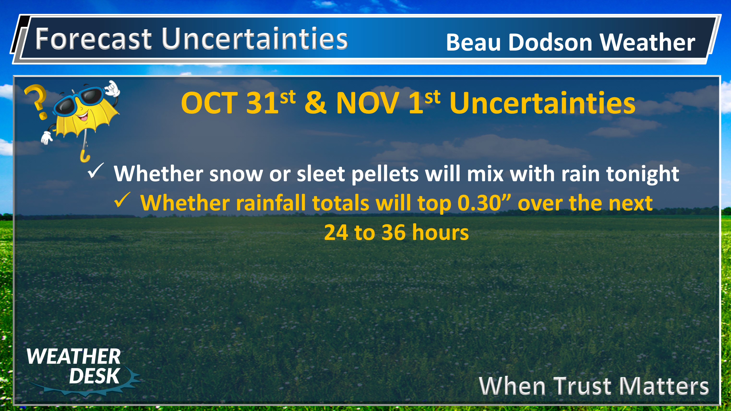
Beau’s Forecast Uncertainties
.
.
.

The National Weather Service definition of a severe thunderstorm is one that produces quarter size hail or larger, 58 mph winds or greater, and/or a tornado.
Tuesday night through Wednesday: No severe weather concerns.
Thursday through Sunday: Lightning is possible on Thursday and perhaps into the weekend. For now, severe weather is not in the forecast. I will monitor trends.
.

Monday night through Friday: Widespread wintry precipitation is not anticipated. A few sleet pellets are possible on Tuesday night as rain develops in the area.
.

Weather Highlights:
An unsettled week of weather ahead of us.
Tonight
Clouds thicken tonight. Rain showers will increase and eventually the atmospheric column will become moist enough for the rain to reach the ground. We could have a mixture of rain, snow pellets, and sleet tonight. Temperatures at the surface, however, will remain above freezing. This will prevent the frozen precipitation from accumulating. It would be a novelty event if it were to occur.
Widespread rain shower activity develops after midnight into Wednesday morning. Some scattered showers are possible before that time, as well.
Rainfall totals tonight will range from a trace to around 0.25″.
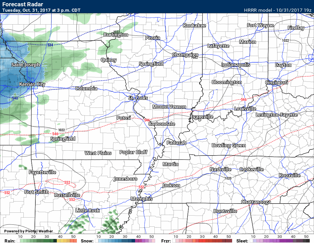
Here is the latest high-resolution Hrrr model future-cast radar animation
Green is rain. Blue would be a mixture of snow/sleet/rain.
This animation goes through Thursday morning. The timestamp is on the top left portion of the image.
Click to enlarge
Wednesday and Wednesday night
Dramatic temperature changes on Wednesday. If you were missing the warm air, then you will enjoy this part of the forecast.
Temperatures will start out in the upper 30’s to lower 40’s on Wednesday morning. Rain showers will be present on Wednesday morning and perhaps into the early afternoon.
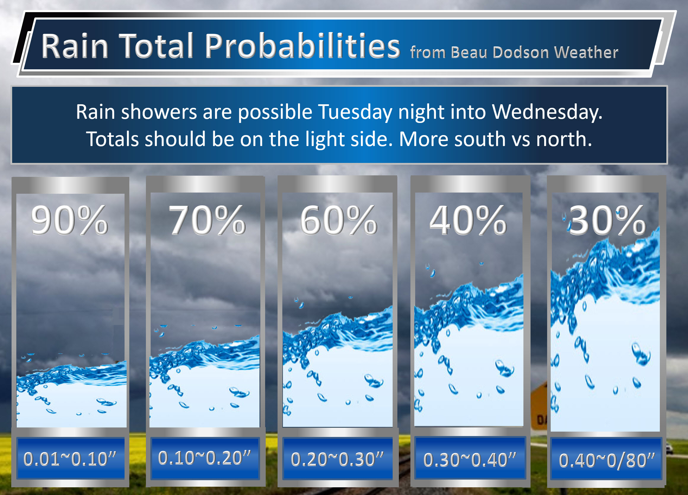
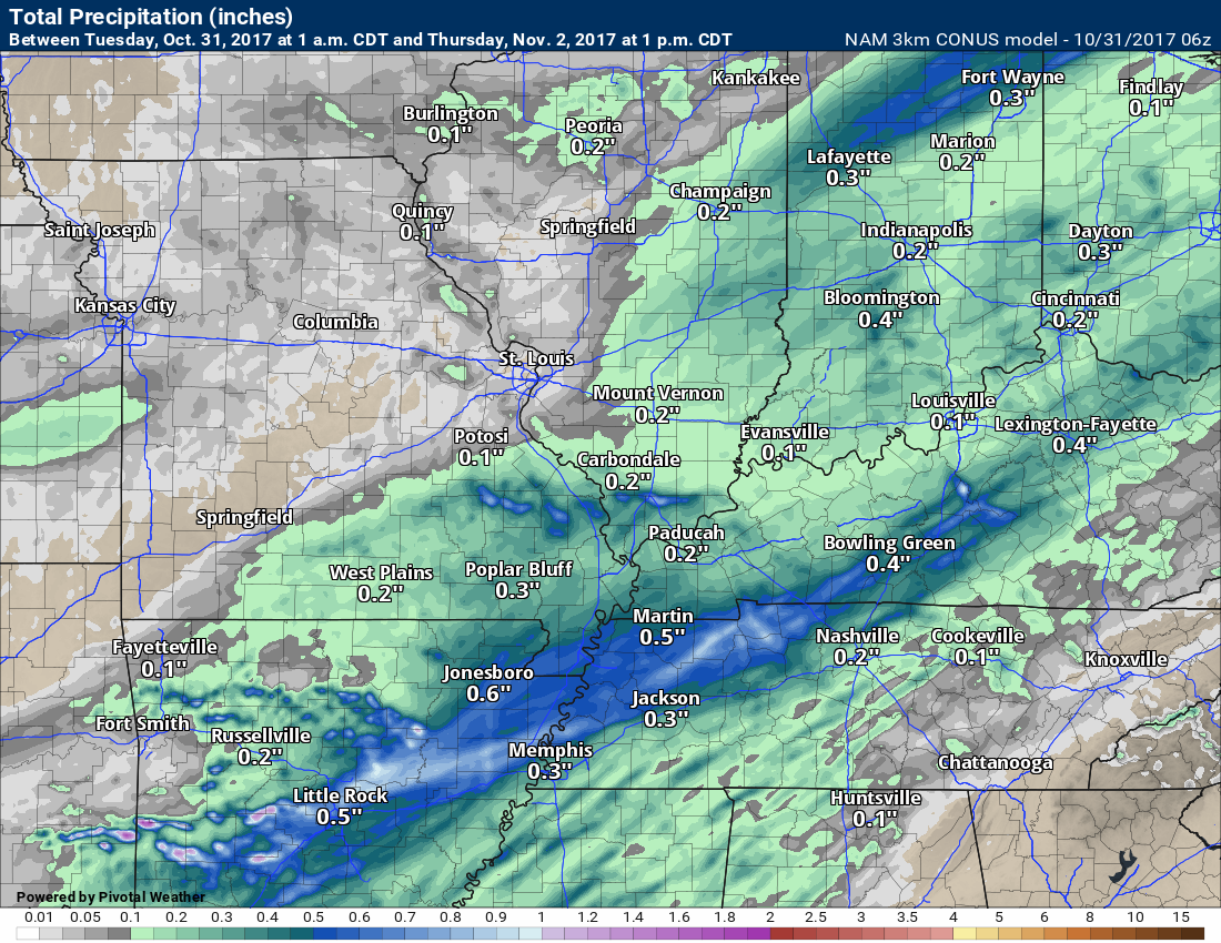
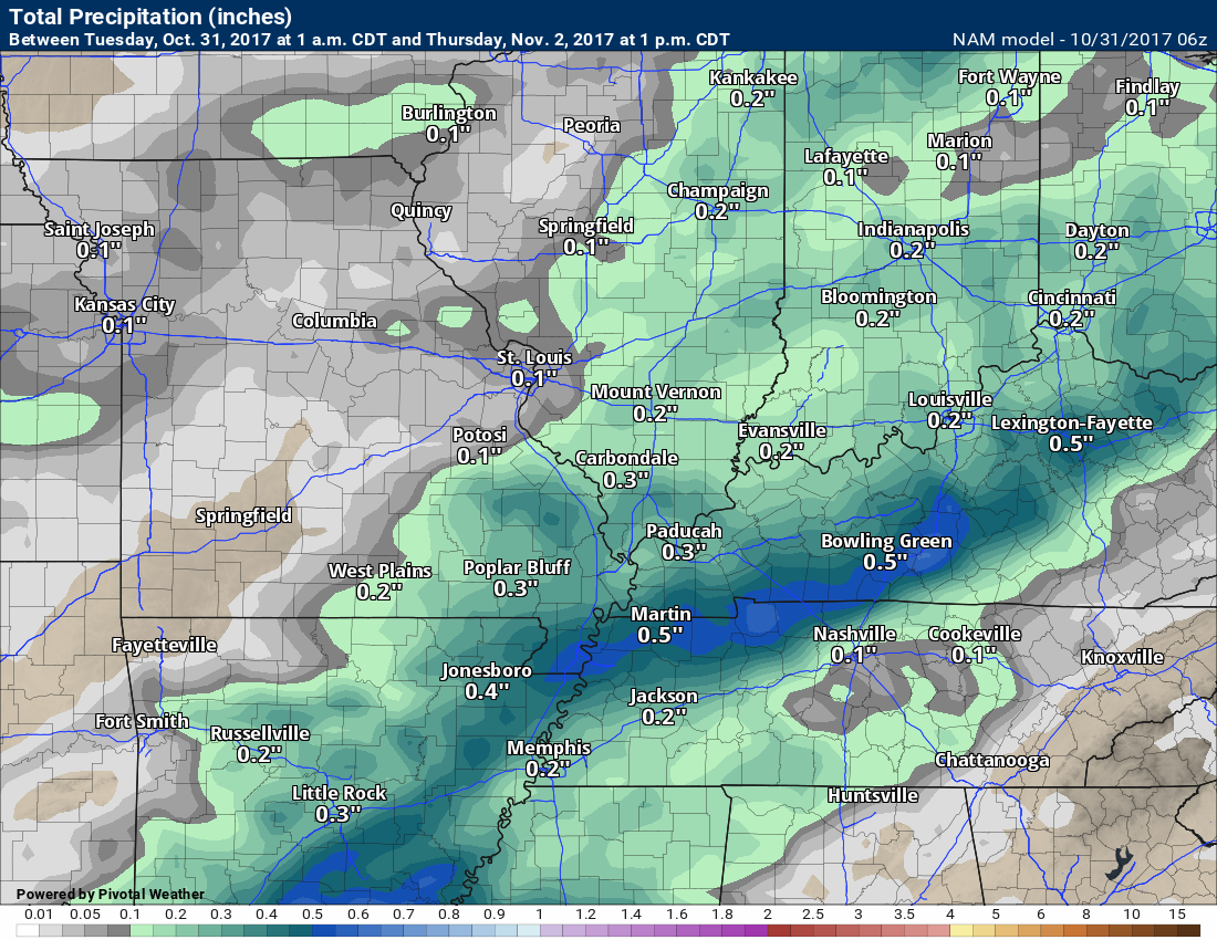
Rain totals from late Tuesday night through Wednesday night will likely be in the 0.01″ to 0.40″ range. Some question as to the extent of the rain over northern parts of southeast Missouri and northern parts of southern Illinois.
Here are my rain forecast probabilities for X amount falling at your location.
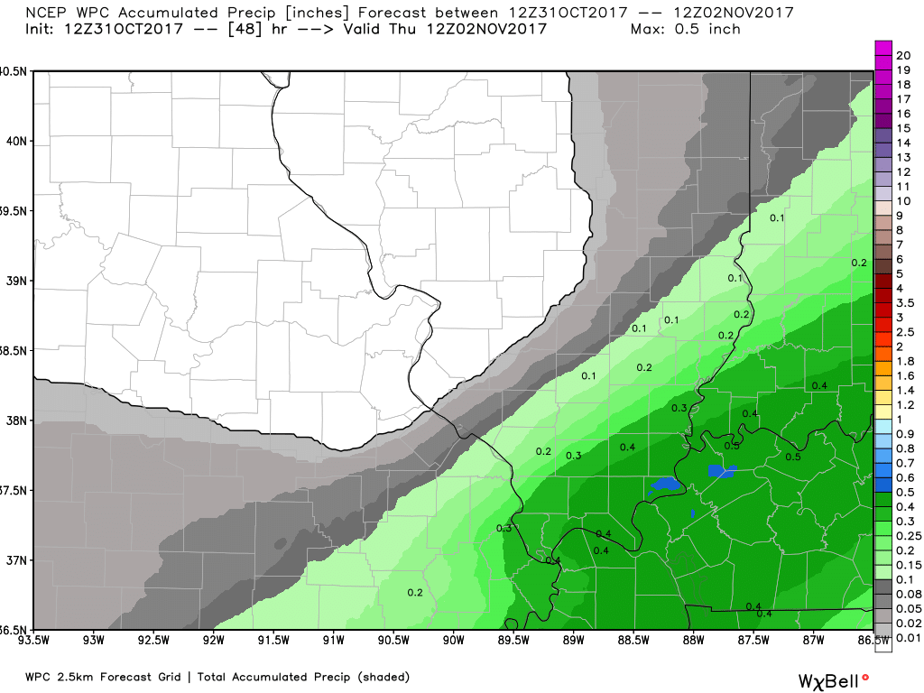
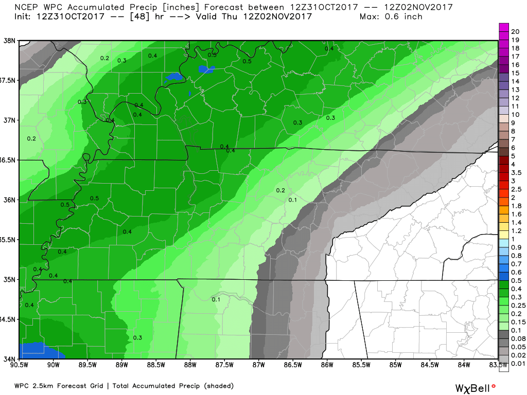
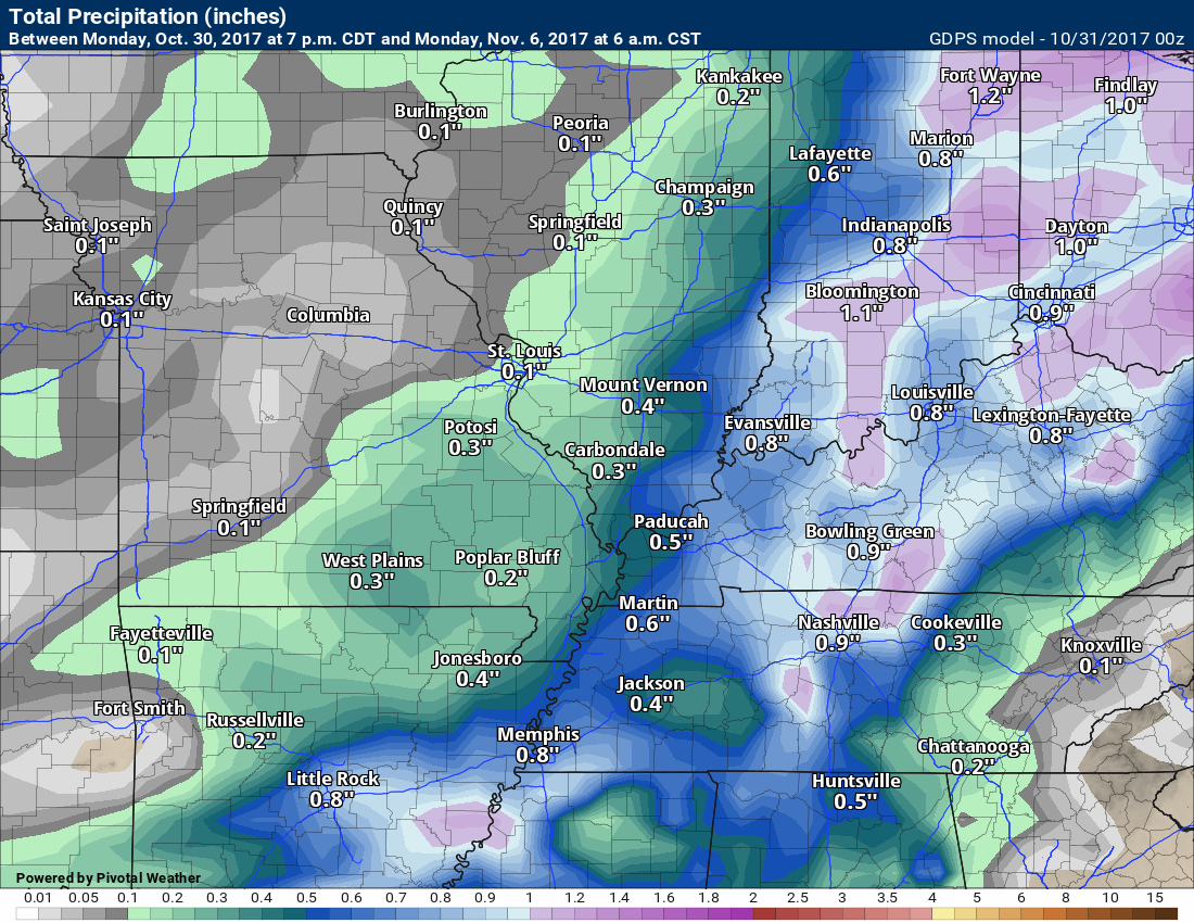
Here are four model projections for rainfall totals from now through Wednesday.
Notice here on the EC model that the NW portion of the region does not receive much rainfall. This is certainly a possibility.
NW view through Wednesday evening
Click images to enlarge.
SE view through Wednesday evening
NAM 3K Model
NAM Model
GFS Model
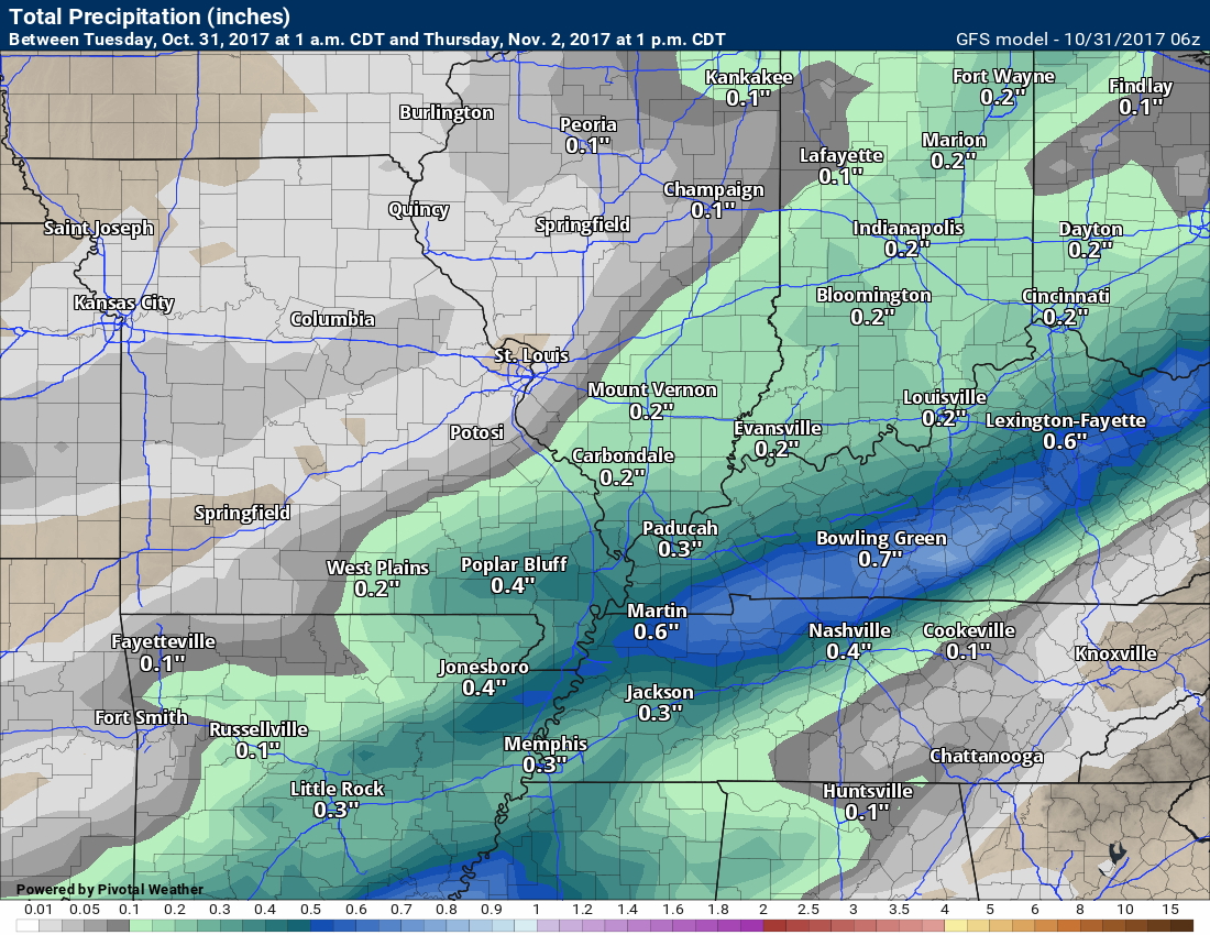
Notice the theme of the above images? Less rainfall northwest vs southeast. Greatest rain totals over our southeast counties.
A strong low-level jet will develop Wednesday afternoon and night. This low-level jet will spread much warmer air into the region.
Low temperatures on Wednesday night will likely occur early in the evening. Temperatures should rise through the night.
Temperatures by Thursday morning will be mostly in the upper 50’s to lower 60’s. Well above the seasonal low temperatures of 42 degrees.
Most of the rain will end by Wednesday night. A few scattered showers will remain, but the widespread rain will have moved off to our east.
Click images to enlarge.
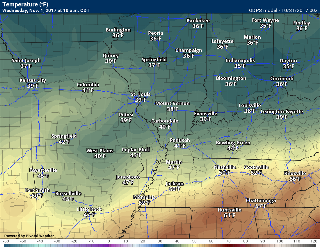
Here is the temperature map for 7 AM on Wednesday. Cool air.
Here is the temperature map for 7 am on Thursday
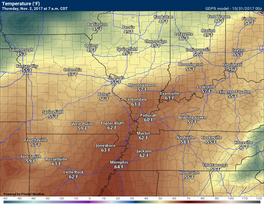
Quite the increase in temperatures.
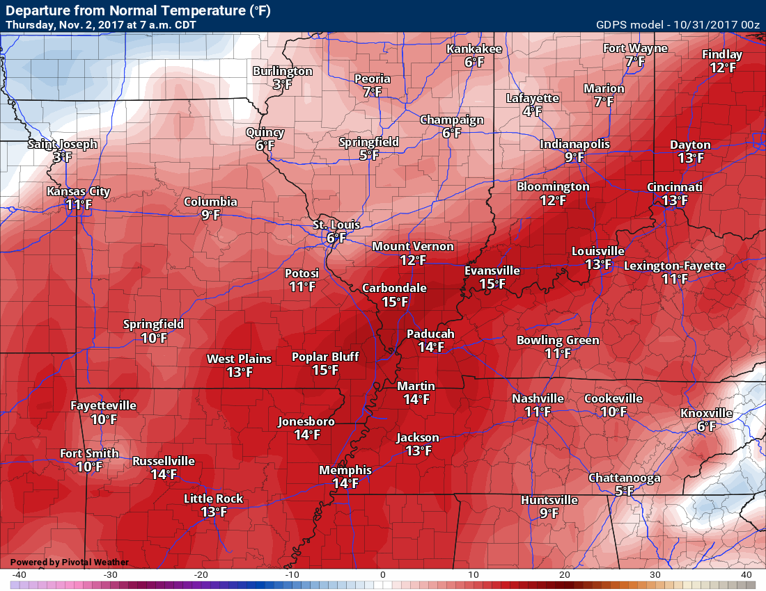
Temperatures at 7 am on Thursday will be several degrees above normal. Talk about a flip!
Temperature anomaly map for Thursday morning.
Thursday into Sunday
It won’t rain all the time, but there will be daily chances of rain. Medium confidence in the overall forecast.
Unsettled weather as we continue to move through the week. Temperatures will rebound well into the 60;s and even 70’s. We will have a daily chance of showers and thunderstorms. The greatest chance will likely by on Friday into Saturday morning.
The threat for severe weather appears small, but I will keep an eye on trends. Severe weather is no stranger to November. Wind fields don’t look all that impressive over the coming week, but again, I will monitor.
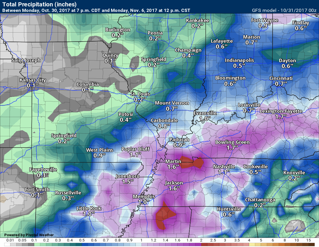
Rainfall totals from now through Sunday will vary quite a bit. This is especially true if some thunderstorms develop.
Here is the GFS model rainfall total forecast into Sunday night
Click images to enlarge.
Canadian model into Sunday night
No solid push of cold air in the forecast.
Are you subscribing to Weather Talk app/text messages and videos? This is what helps support all of the data you see each day.
We now offer premium videos for the short and long-range forecasts! These videos are produced by a team of long-range forecast experts. They are brought to you as bonus information. Activate text option four in order to receive these on your app or via text.
Subscribe at www.beaudodsonweather.com
We offer an Apple and Android app (scroll to the bottom of this page for more information).

Were you aware that I hired a team of meteorologists for long range videos?
To learn more, click this link
http://cms.weathertalk.com/meet-the-team/
.


We offer regional radars and local city radars – if a radar does not update then try another one. Occasional browsers need their cache cleared. You may also try restarting your browser. This will usually fix any problems.
During the winter you can track snow and ice by clicking the winterize button on the local city view interactive radars.
You may email me at beaudodson@usawx.com
Interactive Weather Radar Page. Choose the city nearest your location: Click this link
National interactive radar: Click this link.
The Beau Dodson Weather APP is ready for Apple and Android users. The app provides a faster way for you to receive my text messages. ATT and Verizon are not always reliable when it comes to speed.
Some of you have asked if you can receive the texts on your phone and the app. The answer to that is, yes. The Android app will automatically allow that to happen. On the Apple app, however, you will need to open your app and click the settings button. Make sure the green tab is OFF. Off means you will still receive the texts to your phone and the app. If you have any questions, then email me at beaudodson@usawx.com
The app is for text subscribers.
The direct download, for the Apple app, can be viewed here
https://itunes.apple.com/us/app/id1190136514
Here is the download link for the Android version Click Here
If you have not signed up for the texting service then you may do so at www.beaudodsonweather.com


——————————————————–
Your support helps with the following:

and

.

Whom do you trust for your weather information?
I have studied weather, in our region, since the late 1970’s. I have 40 years of experience in observing our regions weather patterns. My degree is in Broadcast Meteorology and a Bachelor’s of Science.
My resume includes:
Member of the American Meteorological Society.
NOAA Weather-Ready Nation Ambassador.
Meteorologist for McCracken County Emergency Management. I served from 2005 through 2015.
Meteorologist for McCracken County Rescue. 2015 through current
I own and operate the Southern Illinois Weather Observatory.
I am the chief meteorologist for Weather Talk LLC.
I am also a business owner in western Kentucky.
Recipient of the Mark Trail Award, WPSD Six Who Make A Difference Award, Kentucky Colonel, and the Caesar J. Fiamma” Award from the American Red Cross.
In 2005, I helped open the largest American Cross shelter in U.S. history. This was in Houston, Texas. I was deployed to help with the aftermath of Hurricane Katrina and Hurricane Rita. I was a shelter manager of one of the Houston, Texas shelter divisions.
In 2009 I was presented with the Kentucky Office of Highway Safety Award.
Recognized by the Kentucky House of Representatives for my service to the State of Kentucky leading up to several winter storms and severe weather outbreaks.
If you click on the image below you can read the Kentucky House of Representatives Resolution.

I am President of the Shadow Angel Foundation which serves portions of western Kentucky and southern Illinois.
There is a lot of noise on the internet. A lot of weather maps are posted without explanation. You need a trusted source for information.
My forecast philosophy is simple and straight forward.
- Communicate in simple terms
- To be as accurate as possible within a reasonable time frame before an event
- Interact with you on Twitter, Facebook, email, texts, and this blog
- Minimize the “hype” that you might see through other weather sources
- Push you towards utilizing wall-to-wall LOCAL TV coverage during severe weather events

Sign up for my AWARE email by clicking here.
I typically send AWARE emails before severe weather, winter storms, or other active weather situations. I do not email watches or warnings. The emails are a basic “heads up” concerning incoming weather conditions