WeatherTalk monthly operating costs can top $2000.00. Your $5 subscription helps pay for those costs. I work for you.
The $5 will allow you to register up to seven phones!
For $5 a month you can receive the following. You may choose to receive these via your WeatherTalk app or regular text messaging.
Severe weather app/text alerts from my keyboard to your app/cell phone. These are hand typed messages from me to you. During tornado outbreaks, you will receive numerous app/text messages telling you exactly where the tornado is located.
- Daily forecast app/texts from my computer to your app/cell phone.
- Social media links sent directly to your app/cell phone. When I update the blog, videos, or Facebook you will receive the link.
- AWARE emails. These emails keep you well ahead of the storm. They give you several days of lead time before significant weather events.
- Direct access to Beau via text and email. Your very own personal meteorologist. I work for you!
- Missouri and Ohio Valley centered video updates
- Long-range weather videos
- Week one, two, three and four temperature and precipitation outlooks.
Monthly outlooks. - Your subscription also will help support several local charities.
Would you like to subscribe? Subscribe at www.beaudodsonweather.com
Typical progression on a severe weather day for subscribers.


I encourage subscribers to use the app vs regular text messaging. We have found text messaging to be delayed during severe weather. The app typically will receive the messages instantly. I recommend people have three to four methods of receiving their severe weather information.
Remember, my app and text alerts are hand typed and not computer generated. You are being given my personal attention during significant weather events.

WWW.WEATHERTALK.COM subscribers, here is my day to day schedule for your weather products.
These are bonus videos and maps for subscribers. I bring these to you from the BAMwx team. I pay them to help with videos.
The Ohio and Missouri Valley videos cover most of our area. They do not have a specific Tennessee Valley forecast but may add one in the future.
The long-range video is technical. Over time, you can learn a lot about meteorology from the long range video. Just keep in mind, it is a bit more technical.


.
![]()

October 31, 2018
A trick instead of a treat. Rain likely.
Wednesday forecast: Periods of showers and thunderstorms area-wide. Moderate rain possible. Turning cooler northwest to southeast as a cold front pushes slowly south and east.
Temperatures: MO ~ falling into the middle and upper 50’s IL ~ Falling into the upper 50’s over northern parts of southern Illinois and highs in the middle 60’s elsewhere before falling late morning into the afternoon hours KY ~ 64 to 68 with falling temperatures during mainly the PM hours TN ~ 65 to 68 with falling temperatures later in the afternoon/evening
What is the chance of precipitation? MO ~ 100% IL ~ 100% KY ~ 80% TN ~ 80%
Coverage of precipitation: Widespread
Wind: South at 6 to 12 mph with gusts to 20 mph. Winds will shift behind the cold front and become west and northwest at 7 to 14 mph with gusts to 20
What impacts are anticipated from the weather? Lightning possible. Wet roadways.
My confidence in the forecast verifying: High
Is severe weather expected? No
The NWS defines severe weather as 58 mph wind or great, 1″ hail or larger, and/or tornadoes
Should I cancel my outdoor plans? Yes, have a plan B
UV Index: 1 to 2 Low
Sunrise: 7:19 AM
Wednesday Night Forecast Details:
Forecast: Cloudy. Rain. Rain moderate to heavy, at times. Cooler. Some fog possible. Rain won’t be as heavy over northern portions of southeast Missouri and northern portions of southern Illinois. See the rain forecast maps.
Temperatures: MO ~ 44 to 48 IL ~ 44 to 48 KY ~ 48 to 54 TN ~ 48 to 54
What is the chance of precipitation? MO ~ 70% north and 100% elsewhere IL ~ 60% north and 100% elsewhere KY ~ 100% TN ~ 100%
Coverage of precipitation: Widespread
Frost Risk: None
Wind: North at 6 to 12 mph and gusty
What impacts are anticipated from the weather? Wet roadways. Low land flooding possible.
My confidence in the forecast verifying: High
Is severe weather expected? No
The NWS defines severe weather as 58 mph wind or great, 1″ hail or larger, and/or tornadoes
Should I cancel my outdoor plans? Have a plan B
Sunset: 5:58 PM
Moonrise: 11:59 PM Waning Gibbous
Moonset: 2:03 PM
We offer interactive local city view radars and regional radars.
If a radar does not update then try another one. If a radar does not appear to be refreshing then hit Ctrl F5. You may also try restar
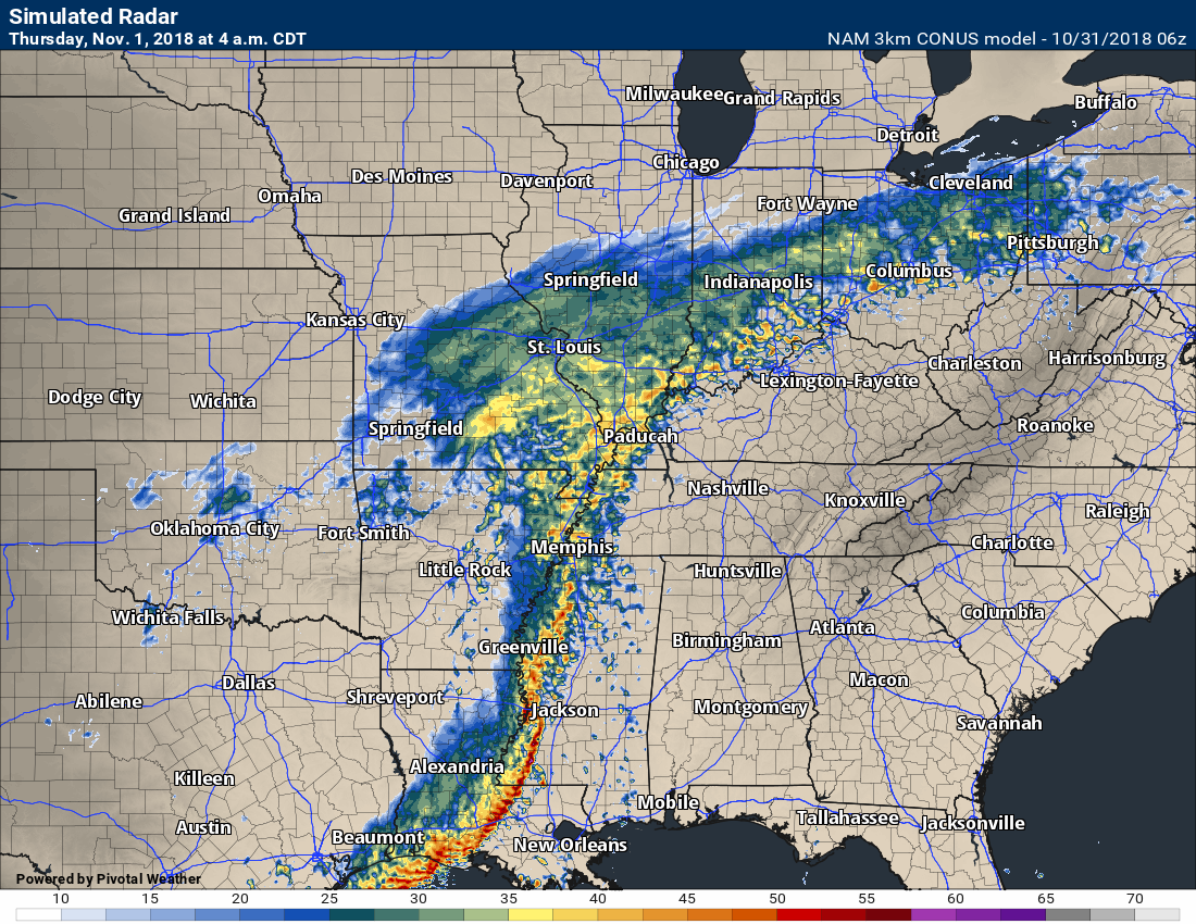
November 1, 2018
Thursday forecast: Cloudy. Rain showers likely. Windy and cooler. Locally moderate to heavy rain possible, especially during the AM hours. Rain won’t be as heavy over northern portions of southeast Missouri and northern portions of southern Illinois. See the rain forecast maps.
Temperatures: MO ~ 52 to 54 IL ~ 52 to 54 KY ~ 54 to 56 TN ~ 54 to 56
What is the chance of precipitation? MO ~ 60% IL ~ 60% KY ~ 70% TN ~ 70%
Coverage of precipitation: Scattered to perhaps numerous
Wind: North at 8 to 16 mph with gusts above 25 mph
What impacts are anticipated from the weather? Wet roadways. Some low land flooding possible. Monitor river crest forecasts over the coming days, as well.
My confidence in the forecast verifying: High
Is severe weather expected? No
The NWS defines severe weather as 58 mph wind or great, 1″ hail or larger, and/or tornadoes
Should I cancel my outdoor plans? Have a plan B
UV Index: 1 to 3 Low
Sunrise: 7:20 AM
Thursday Night Forecast Details:
Forecast: Cloudy. Showers possible. Chilly.
Temperatures: MO ~ 36 to 40 IL ~ 36 to 40 KY ~ 38 to 42 TN ~ 38 to 44
What is the chance of precipitation? MO ~ 40% IL ~ 40% KY ~ 50% TN ~ 50%
Coverage of precipitation: Scattered
Frost Risk: Most likely no
Wind: North and northwest at 7 to 14 mph
What impacts are anticipated from the weather? Wet roadways
My confidence in the forecast verifying: Medium to high
Is severe weather expected? No
The NWS defines severe weather as 58 mph wind or great, 1″ hail or larger, and/or tornadoes
Should I cancel my outdoor plans? Have a plan B
Sunset: 5:57 PM
Moonrise: 12:33 PM Last Quarter
Moonset: 2:47 PM
November 2, 2018
Friday forecast: Partly cloudy. A shower possible.
Temperatures: MO ~ 54 to 58 IL ~ 54 to 58 KY ~ 56 to 60 TN ~ 58 to 62
What is the chance of precipitation? MO ~ 30% IL ~ 30% KY ~ 30% TN ~ 30%
Coverage of precipitation: Widely scattered
Wind: Northwest at 5 to 10 mph
What impacts are anticipated from the weather? Wet roadways
My confidence in the forecast verifying: Medium
Is severe weather expected? No
The NWS defines severe weather as 58 mph wind or great, 1″ hail or larger, and/or tornadoes
Should I cancel my outdoor plans? No, but check radars
UV Index: 4 to 5 Moderate
Sunrise: 7:21 AM
Friday Night Forecast Details:
Forecast: Mostly cloudy. Chilly. A shower possible.
Temperatures: MO ~ 35 to 40 IL ~ 35 to 40 KY ~ 36 to 42 TN ~ 40 to 44
What is the chance of precipitation? MO ~ 20% IL ~ 20% KY ~ 20% TN ~ 20%
Coverage of precipitation: Isolated
Frost Risk: No
Wind: Winds becoming west and northwest at 5 to 10 mph with gusts to 14 mph
What impacts are anticipated from the weather? A few wet roadways
My confidence in the forecast verifying: Medium
Is severe weather expected? No
The NWS defines severe weather as 58 mph wind or great, 1″ hail or larger, and/or tornadoes
Should I cancel my outdoor plans? No, but check radars
Sunset: 5:56 PM
Moonrise: 1:41 AM Waning Crescent
Moonset: 3:26 PM
November 3, 2018
Saturday forecast: Partly to mostly. Cool temperatures.
Temperatures: MO ~ 56 to 62 IL ~56 to 62 KY ~ 58 to 64 TN ~ 58 to 64
What is the chance of precipitation? MO ~ 0% IL ~ 0% KY ~ 0% TN ~ 0%
Coverage of precipitation: None
Wind: West at 6 to 12 mph
What impacts are anticipated from the weather? None
My confidence in the forecast verifying: High
Is severe weather expected? No
The NWS defines severe weather as 58 mph wind or great, 1″ hail or larger, and/or tornadoes
Should I cancel my outdoor plans? No
UV Index: 4 to5 Moderate
Sunrise: 7:22 AM
Saturday Night Forecast Details:
Forecast: Partly cloudy.
Temperatures: MO ~ 44 to 48 IL ~ 44 to 48 KY ~ 44 to 48 TN ~ 44 to 48
What is the chance of precipitation? MO ~ 0% IL ~ 0% KY ~ 0% TN ~ 0%
Coverage of precipitation: None
Frost Risk: No
Wind: Becoming east and southeast at 5 to 10 mph with gusts to 14 mph
What impacts are anticipated from the weather? None
My confidence in the forecast verifying: Medium
Is severe weather expected? No
The NWS defines severe weather as 58 mph wind or great, 1″ hail or larger, and/or tornadoes
Should I cancel my outdoor plans? No
Sunset: 5:55 PM
Moonrise: 2:49 PM Waning Crescent
Moonset: 4:03 PM
November 4, 2018
Sunday forecast: Mostly cloudy with showers possible. Mild.
Temperatures: MO ~ 58 to 64 IL ~ 58 to 64 KY ~ 58 to 64 TN ~ 58 to 64
What is the chance of precipitation? MO ~ 30% IL ~ 30% KY ~ 30% TN ~ 30%
Coverage of precipitation: Scattered
Wind: South at 8 to 16 mph
What impacts are anticipated from the weather? Wet roadways
My confidence in the forecast verifying: Medium
Is severe weather expected? No
The NWS defines severe weather as 58 mph wind or great, 1″ hail or larger, and/or tornadoes
Should I cancel my outdoor plans? No, but check radars
UV Index: 3 to 5 Moderate
Sunrise: 6:23 AM
Sunday Night Forecast Details:
Forecast: Mostly cloudy. A shower again possible.
Temperatures: MO ~ 44 to 48 IL ~ 44 to 48 KY ~ 44 to 48 TN ~ 44 to 48
What is the chance of precipitation? MO ~ 20% IL ~ 20% KY ~ 20% TN ~ 20%
Coverage of precipitation: Widely scattered
Frost Risk: None
Wind: South 5 to 10 mph
What impacts are anticipated from the weather? Wet roadways.
My confidence in the forecast verifying: Medium
Is severe weather expected? No
The NWS defines severe weather as 58 mph wind or great, 1″ hail or larger, and/or tornadoes
Should I cancel my outdoor plans? Monitor updates
Sunset: 4:54 PM
Moonrise: 2:56 PM Waning Gibbous
Moonset: 3:37 PM
November 5, 2018
Monday forecast: Partly cloudy. A shower possible.
Temperatures: MO ~ 62 to 66 IL ~ 62 to 66 KY ~ 62 to 66 TN ~ 62 to 66
What is the chance of precipitation? MO ~ 20% IL ~ 20% KY ~ 20% TN ~ 20%
Coverage of precipitation: Isolated
Wind: South at 5 to 10 mph
What impacts are anticipated from the weather? Wet roadways
My confidence in the forecast verifying: Medium
Is severe weather expected? No
The NWS defines severe weather as 58 mph wind or great, 1″ hail or larger, and/or tornadoes
Should I cancel my outdoor plans? No, but check updates
UV Index: 3 to 5 Moderate
Sunrise: 6:24 AM
Monday Night Forecast Details:
Forecast: Clearing and cool. Patchy fog possible.
Temperatures: MO ~ 46 to 52 IL ~ 46 to 52 KY ~ 50 to 54 TN ~ 50 to 54
What is the chance of precipitation? MO ~ 0% IL ~ 0% KY ~ 0% TN ~ 0%
Coverage of precipitation: None
Frost Risk: No
Wind: South at 4 to 8 mph
What impacts are anticipated from the weather? None
My confidence in the forecast verifying: Medium
Is severe weather expected? No
The NWS defines severe weather as 58 mph wind or great, 1″ hail or larger, and/or tornadoes
Should I cancel my outdoor plans? No
Sunset: 4:53 PM
Moonrise: 4:02 PM Waning Gibbous
Moonset: 4:09 PM
Learn more about the UV index readings. Click here.

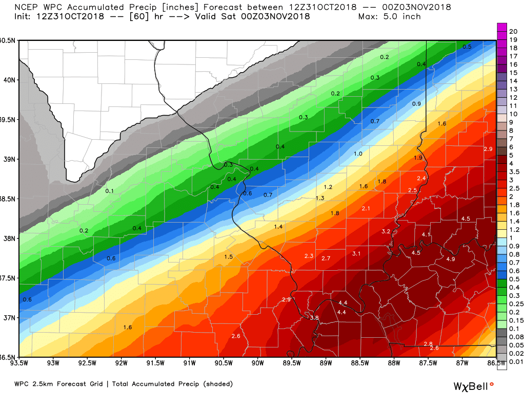
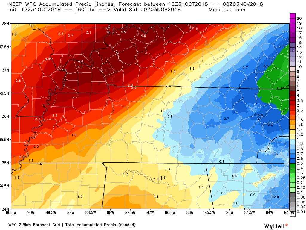
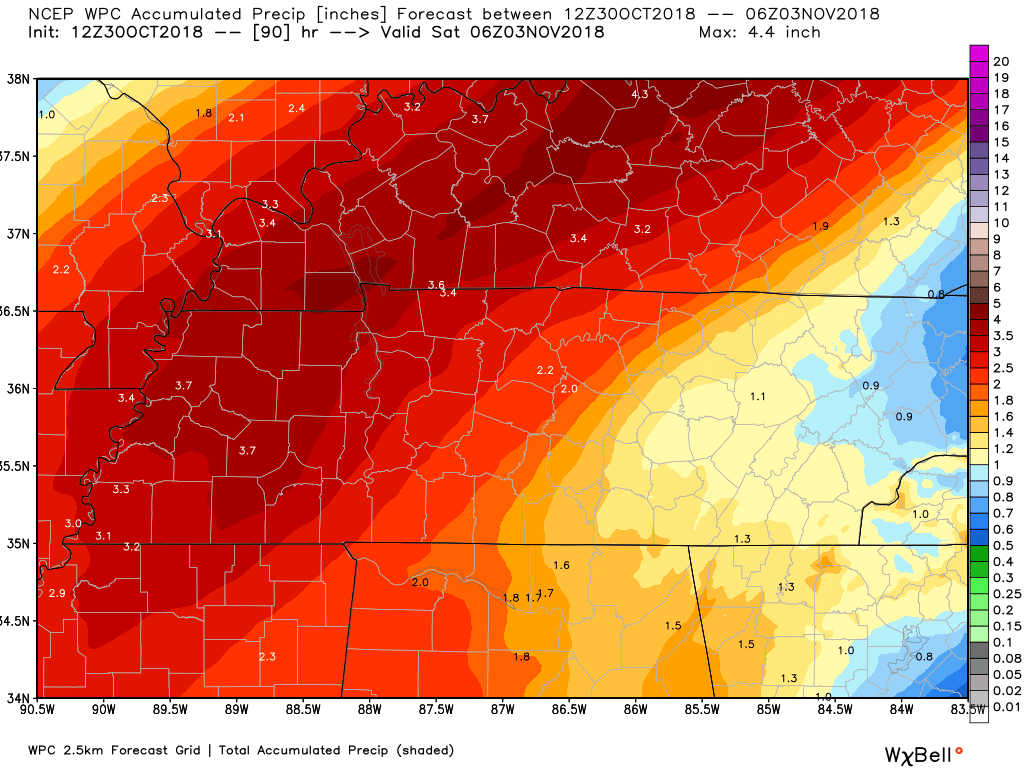
Here is the WPC/NOAA rainfall outlook
These first two graphics are for this first rain event today into Thursday.
Click images to enlarge them.
I wanted to show you something in the forecast charts.
Notice the line of storms to our south tonight?
Sometimes these thunderstorms complexes to our south can cut into our rain totals. Why? The reason is they rob us of moisture transport northward from the Gulf of Mexico.
In other words, they take away the amount of moisture that spreads northward.
This could impact our rain totals.
Take the general idea from these graphics (not the specifics). Rain totals will always vary.
Notice the very sharp gradient of low totals vs high totals.
This is the WPC/NOAA forecast
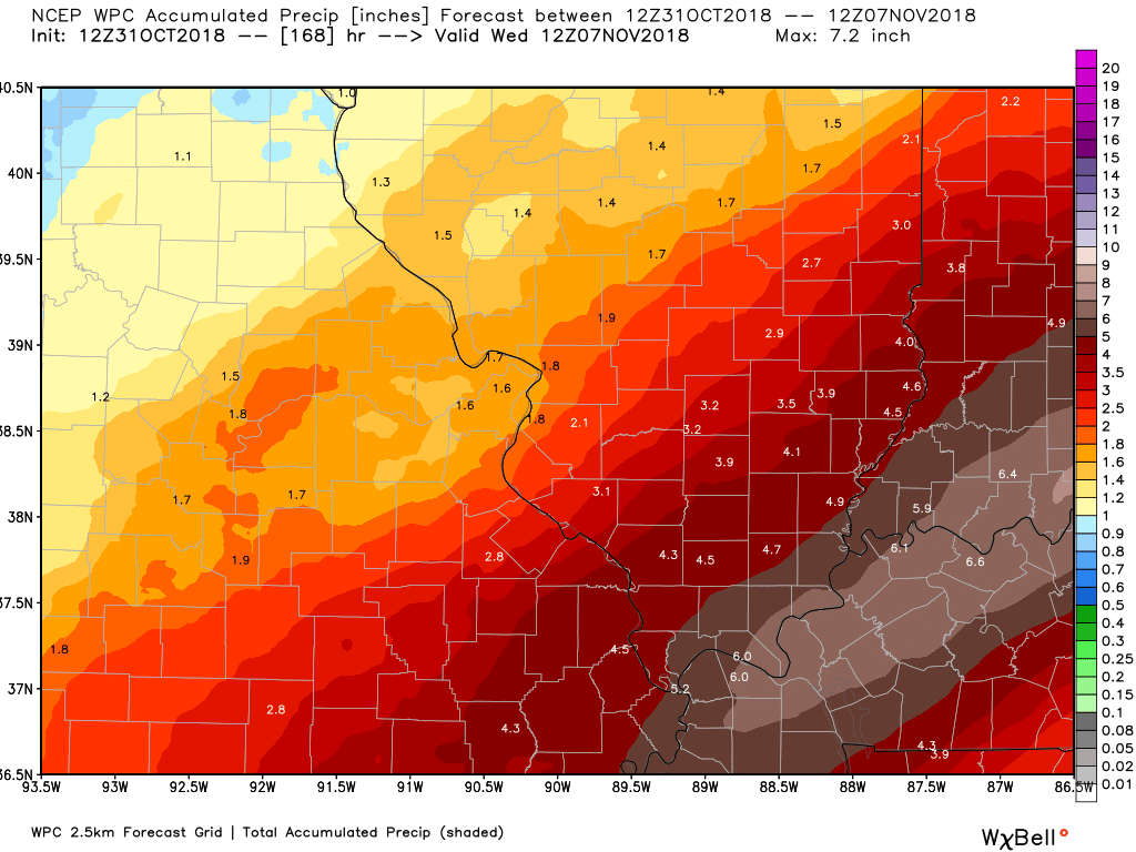
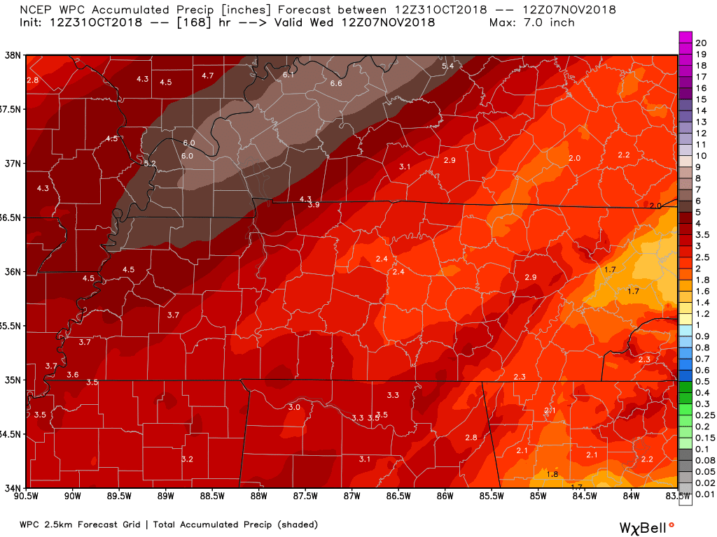
This next set of graphics is the WPC seven day rainfall outlook.
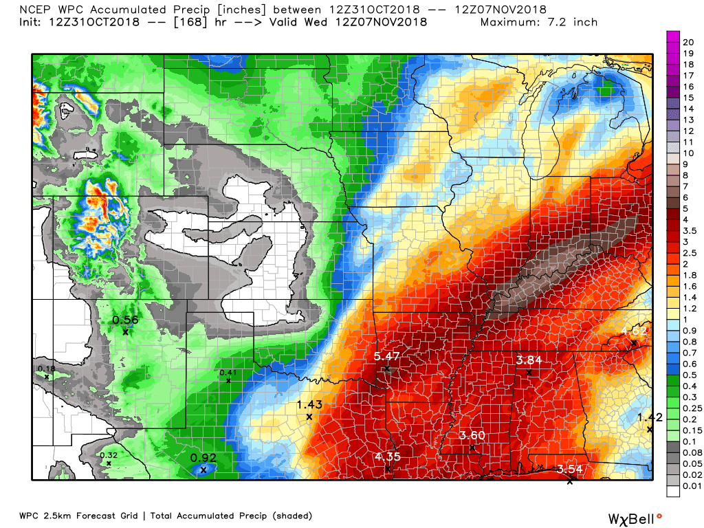
This would be a lot of rain in the river basins. River flooding concerns are increasing.
Zooming in on southeast Missouri and southern Illinois
Here is the southeast Missouri and southern Illinois view.
Notice the sharp gradient in rain totals.
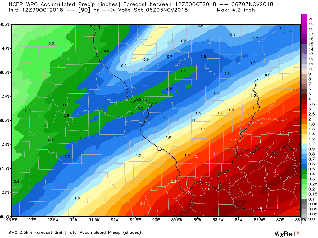
Here is the seven-day rainfall outlook.
That is why these numbers increase.
This is a lot of water in the Ohio and Tennessee River basin. Some river flooding appears likely over the coming two to three weeks.
Click to enlarge this graphic.
Seven day WPC rainfall forecast zoomed in on our area.
Click images to enlarge them.
This is the WPC rainfall totals forecast from now through next Wednesday morning.
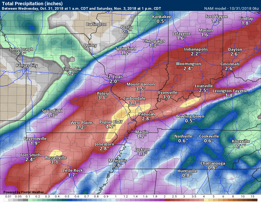
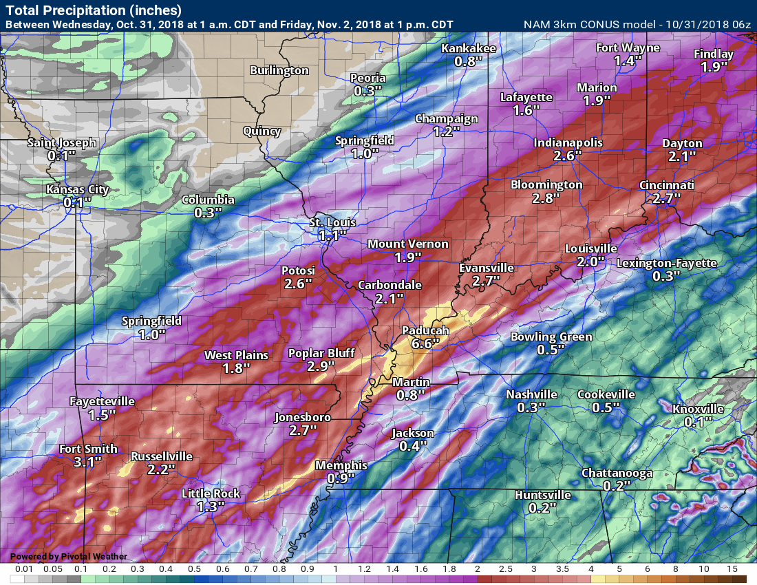
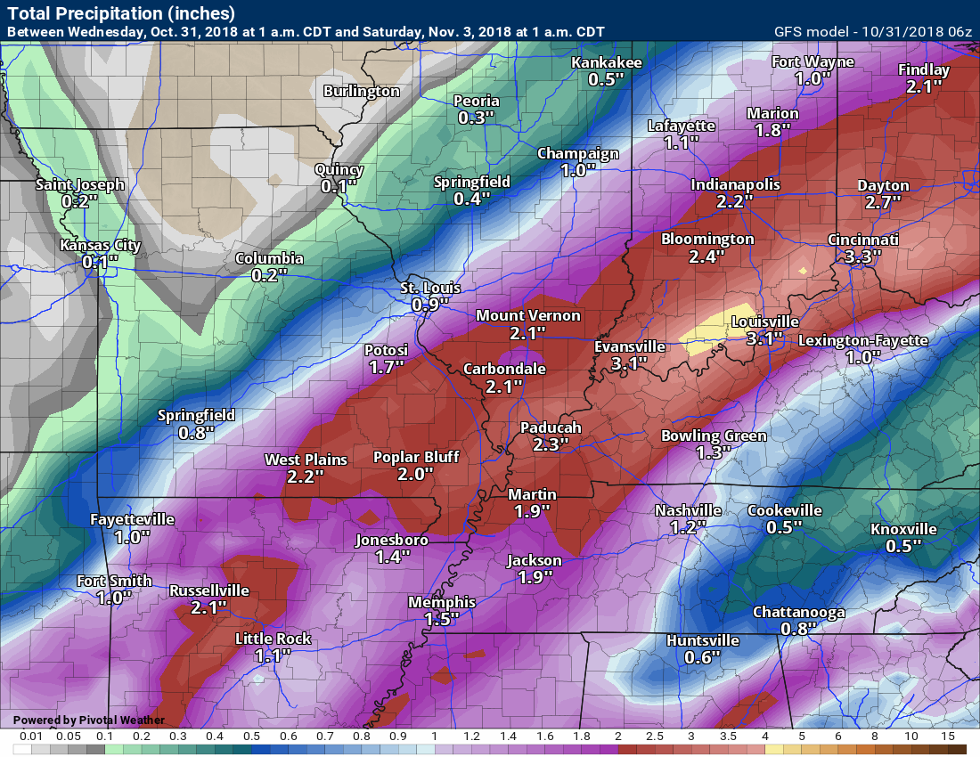
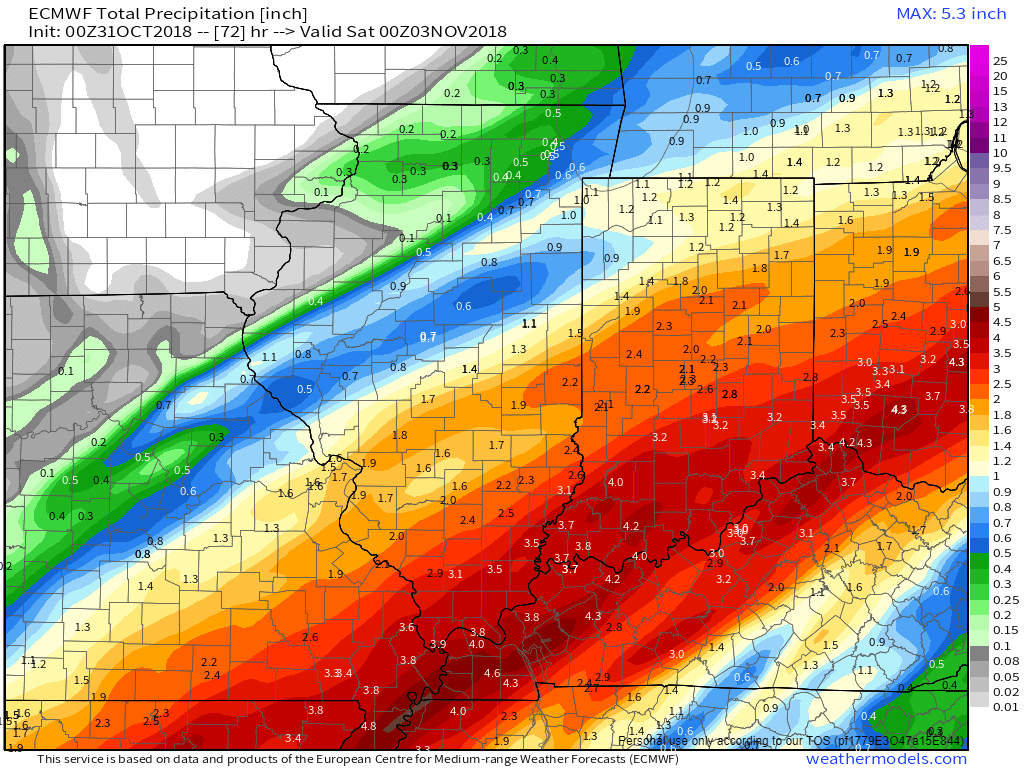
What I want you to take from these following graphics are not the specifics. I want you to take the general idea of where model guidance is placing the heaviest band of rainfall.
Most of the guidance points to far southeast Missouri into extreme southern Illinois and then Kentucky and Tennessee. A widespread one to three-inch rain event is forecast with pockets of higher totals likely.
This next graphic is the regular NAM model guidance rainfall totals forecast.
This next graphic is the 3K NAM model guidance rainfall totals forecast.
This next graphic is the GFS model guidance rainfall totals forecast.
This graphic is the Canadian model guidance rainfall totals.
Here is the EC model guidance rainfall totals. This is for today’s event into Thursday.
Did you know that you can find me on Twitter?

Subscribers, do you need a forecast for an outdoor event?


We offer interactive local city live radars and regional radars.
If a radar does not update then try another one. If a radar does not appear to be refreshing then hit Ctrl F5 on your keyboard.
You may also try restarting your browser. The local city view radars also have clickable warnings.
During the winter months, you can track snow and ice by clicking the winterize button on the local city view interactive radars.

Questions? Broken links? Other questions?
You may email me at beaudodson@usawx.com

The National Weather Service defines a severe thunderstorm as one that produces quarter size hail or larger, 58 mph winds or greater, and/or a tornado.
Today through next Saturday: Severe weather is not anticipated. Lightning is possible today and tonight. Moderate to heavy rain is possible Wednesday and Wednesday night. A wet Halloween.
I am monitoring next week for additional thunderstorms. Monitor updates.
Interactive live weather radar page. Choose the city nearest your location. If one of the cities does not work then try a nearby one. Click here.
National map of weather watches and warnings. Click here.
Storm Prediction Center. Click here.
Weather Prediction Center. Click here.

Live lightning data: Click here.

Interactive GOES R satellite. Track clouds. Click here.

Here are the latest local river stage forecast numbers Click Here.
Here are the latest lake stage forecast numbers for Kentucky Lake and Lake Barkley Click Here.

- Rain rain rain
- Low-land flooding possible across parts of the area
- Our northern and northwestern counties won’t receive nearly as much rain as areas further south and southeast.
- Cooler temperatures
- Monitoring rain chances Friday and Sunday
- Another rain event possible next week
For the last thirty days we have been talking about a significant weather system around Halloween.
It has arrived.
Radar shows rain spreading across the region from the west.
The rain will continue to stream into the region throughout the day into tonight and tomorrow morning.
We will have numerous showers on the weather radars today. Some thunderstorms are also possible. No severe thunderstorms locally. That is the good news.
The rain will become heavier tonight as an area of low pressure develops along the cold front. This will serve two purposes. It will stall the frontal boundary over our region. It will also increase the amount of moisture pulled into the area from the Gulf of Mexico.
PWAT values will be the top of the charts for October. PWAT values are used to measure the amount of moisture in the entire atmospheric column.
Forecasters use PWAT to forecast heavy rain.
I usually monitor for a prolonged period of high PWAT values. Prolonged meaning 12 or more hours. That typically means that heavy rain is more likely to occur in those areas.
I am seeing that with this event. Thus, some moderate to heavy rain is being forecast.
Here is the PWAT animation.

One fly in the ointment will be a line of thunderstorms that is forecast to develop from Arkansas into the Gulf of Mexico. If this system is strong enough then it could rob us of moisture. This is not uncommon during the fall and winter months.
If this happens then rain totals will be less. Keep this in mind.
This increase in moisture levels will help produce a widespread one to two-inch rain event with pockets of two to four inches likely.
The heaviest band of rain will likely be near the Ohio River.
Areas along and north of a line from Perry County, Missouri, towards Carmi, Illinois, will likely receive 0.50″ to 1.00″ of rain. Perhaps a bit more. That will be the area of least amount of rain (locally).
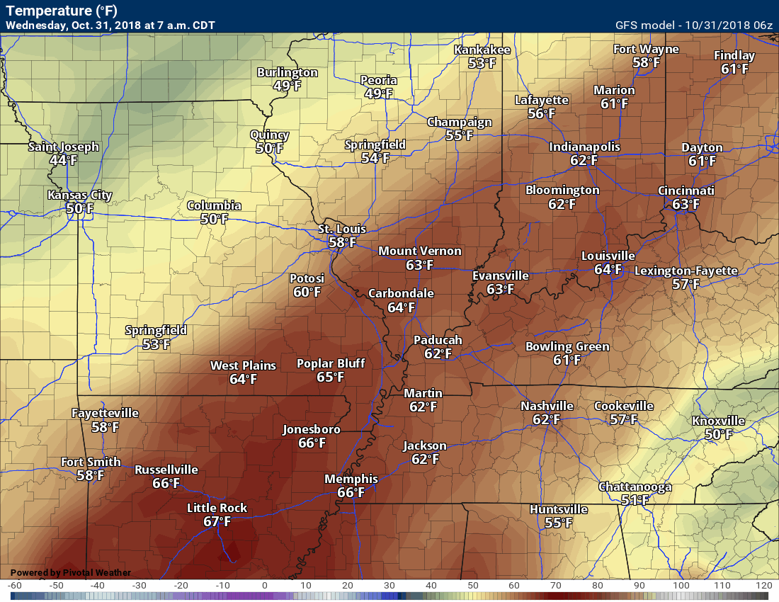
Temperatures today will peak during the early part of the day across much of southeast Missouri and southern Illinois. Temperatures will fall into the 50’s as the cold front continues to slowly push south and southeast.
Here is the temperature animation for today into tonight.
Notice the cooling temperatures moving northwest to southeast across the region. That occurs as the cold front moves south and east. Cooler behind the front.
Click image to enlarge
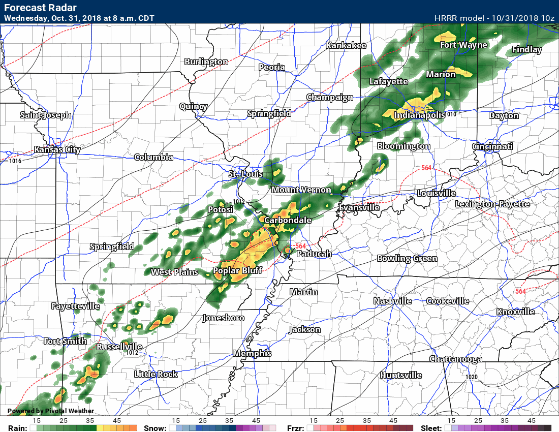
Here is the future-cast radar. This is the Hrrr model. This is a high-resolution model.
Notice the surge of moisture tonight. That is the heavier band of rain that will push through the region. Tonight into Thursday morning is when the heaviest rain will occur.
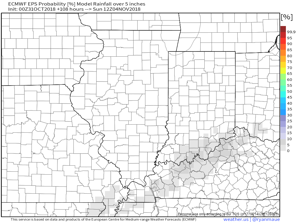
Let’s look at the EC model guidance probabilities for two or more inches of rain

And the probability of five or more inches of rain.
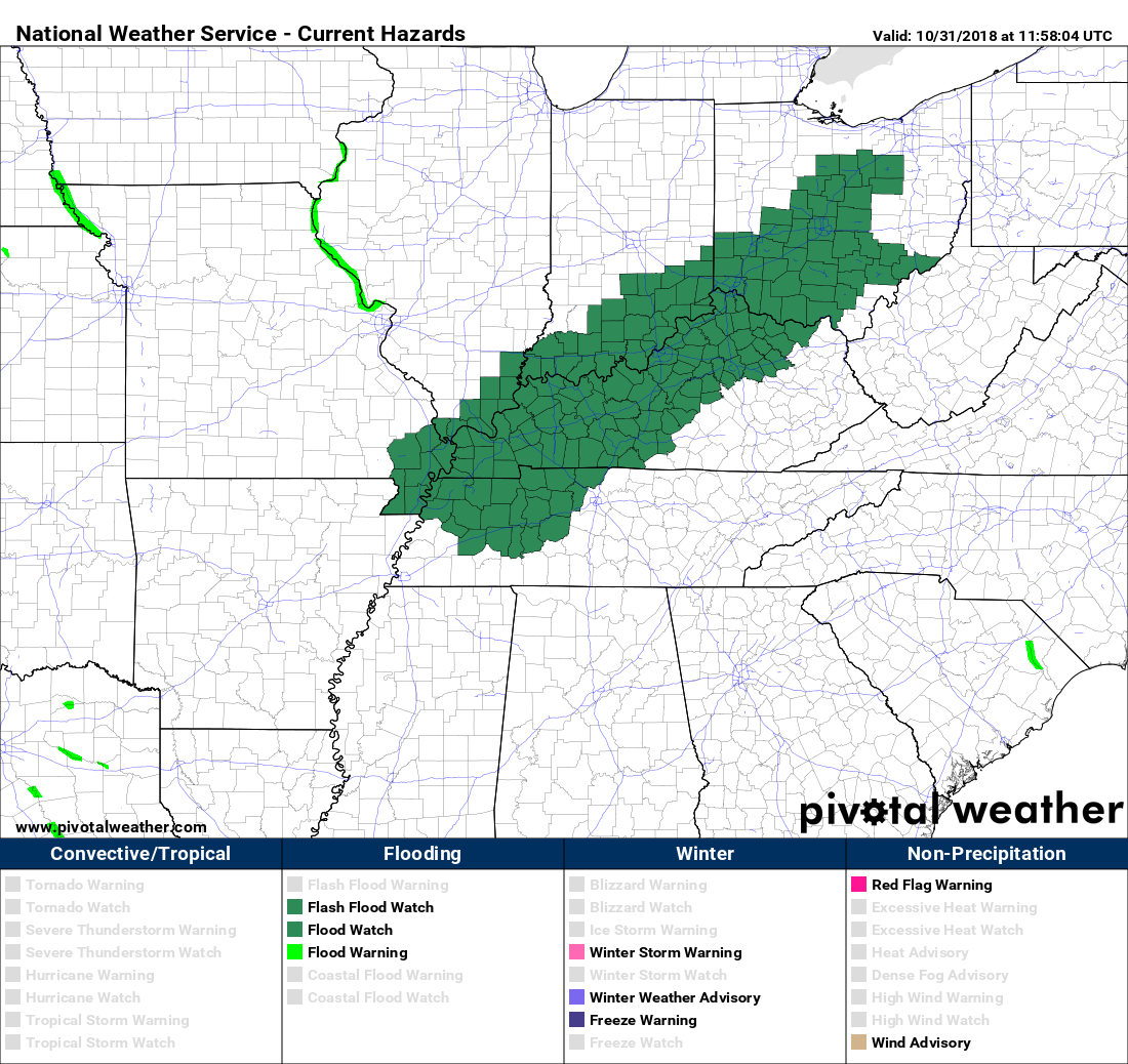
The NWS has issued flood watches for several of my forecast counties.
The bright blue represents river flood warnings. The rest of the blue color represents the flood watch.
Click to enlarge

Zooming out a bit. You can see the flood watches extend into Ohio.
The green is the flood watch (sorry, I should have made them the same color).
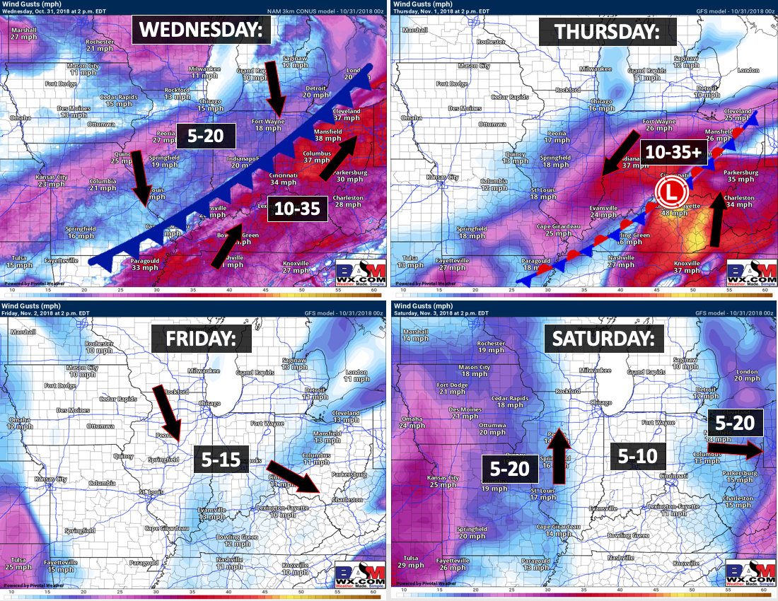
Winds will be gusty over the coming 24 to 48 hours. Winds will be from the south if you are south of the cold front. Winds will become north and northwest aas the front passes through your county.
Friday into Monday
A few light showers are possible Friday and Sunday. No heavy rain. No severe storms.
Saturday should be dry.
I am watching a larger system next week. That one could bring additional heavy rain and possibly thunderstorms. Let’s keep an eye on it. We won’t need additional rain by the time it arrives.
Watching another system around November 20th to the 24th.
Another system arrives next week.
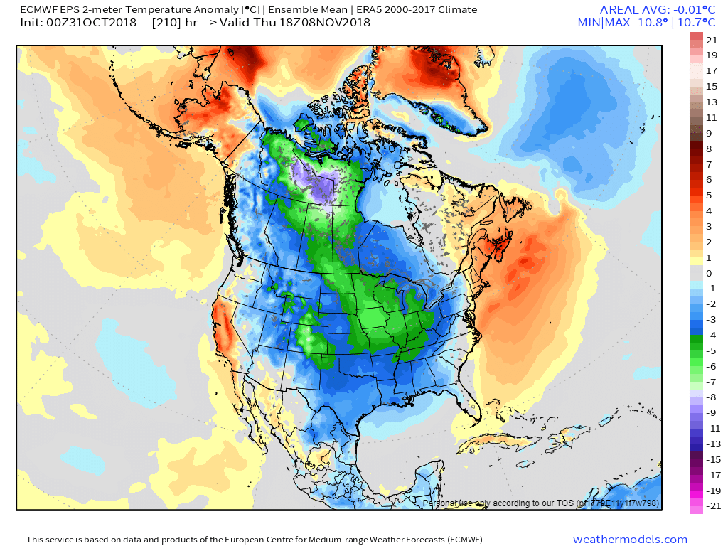
You are looking at the temperature anomaly map. How many degrees above or below normal will temperatures be?
Red is above and blue is below.
Notice how we warm up ahead of the next system. That is because low pressure rotates counter-clockwise. It will pull moisture and warmer temperatures northward.
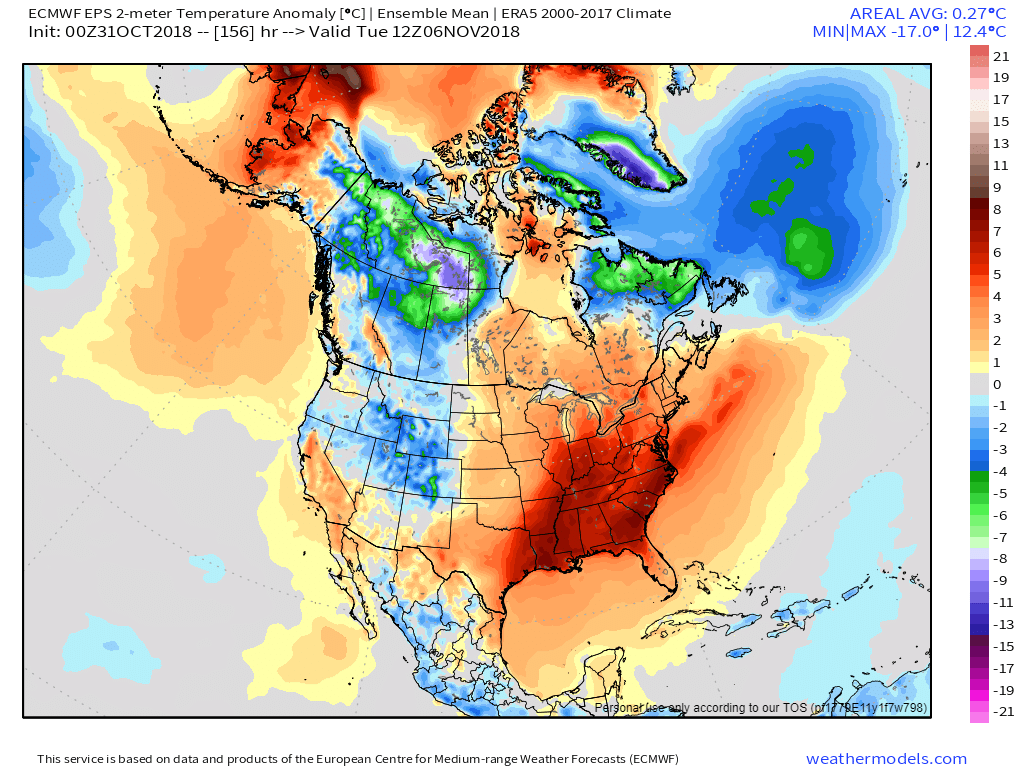
Watch what happens once the front passes through the area. Below normal temperatures.
![]()

I bring these to you from the BAMwx team. They are excellent long-range forecasters.
Remember, long-range outlooks are a bit of skill, understanding weather patterns, and luck combined. It is not an exact science.

This product is for subscribers.
Subscribe at www.weathertalk.com
Subscriber graphics can be viewed on this page CLICK HERE

This product is for subscribers.

This product is for subscribers.
Subscribe at www.weathertalk.com
Subscriber graphics can be viewed on this page CLICK HERE
![]()
.
Fall Outlook!
Preliminary October precipitation outlook
.
Here is the preliminary November temperature and precipitation outlook
.
Preliminary November temperature outlook
Preliminary November precipitation outlook
.These products are for subscribers.
![]()

A new weather podcast is now available! Weather Geeks (which you might remember is on The Weather Channel each Sunday)
To learn more visit their website. Click here.
![]()

WeatherBrains Episode 666
This week’s Guest WeatherBrain is a world-renowned meteorologist, prognosticator, and extended outlook specialist. A 1978 graduate of Penn State University with a Bachelor of Science in Meteorology and former Nittany Lion Wrestler, he worked at AccuWeather soon after graduation. He currently works for WeatherBELL Analytics as co-Chief Forecaster. Joe Bastardi, welcome to WeatherBrains!
Other discussions in this weekly podcast include topics like:
Other discussions in this weekly podcast include topics like:
Hurricane Willa approaches the Mexican coast
Winter weather outlook from the panel
Astronomy Outlook with Tony Rice
and more!
Link to their website https://weatherbrains.com/
Previous episodes can be viewed by clicking here.

We offer interactive local city live radars and regional radars. If a radar does not update then try another one. If a radar does not appear to be refreshing then hit Ctrl F5. You may also try restarting your browser.
The local city view radars also have clickable warnings.
During the winter months, you can track snow and ice by clicking the winterize button on the local city view interactive radars.
You may email me at beaudodson@usawx.com
Find me on Facebook!

Find me on Twitter!

Did you know that a portion of your monthly subscription helps support local charity projects?
You can learn more about those projects by visiting the Shadow Angel Foundation website and the Beau Dodson News website.

I encourage subscribers to use the app vs regular text messaging. We have found text messaging to be delayed during severe weather. The app typically will receive the messages instantly. I recommend people have three to four methods of receiving their severe weather information.
Remember, my app and text alerts are hand typed and not computer generated. You are being given personal attention during significant weather events.
