

.
A Weather Talk subscription ($3 a month) is required to view the videos. This helps cover monthly costs (which can run between one and two thousand dollars).
Videos are posted on the www.weathertalk.com website. Once there, click the Beau Video-Cast tab. Long Range Video Update
If you believe you missed a video then you may check the LIVE FEED link on the Weather Talk website. You will find an archive of videos on that page.
You can also receive the videos via your Weather Talk app/text messages. Turn text option FOUR to the on position. The Weather Extra text option. Sign up for the app/text messages, videos, and more at www.beaudodsonweather.com
.
This forecast covers the counties in red. The counties in orange are covered by the forecast discussion further down in the blog.


.
October 24, 2017
Tuesday Night Forecast Details:
Forecast: Partly cloudy early and then some clearing. Colder. If the winds subside then a chance of patchy frost. A small chance of an evening shower.
Temperatures: MO ~ 34 to 38 IL ~ 35 to 40 KY ~ 35 to 40
Winds: Northwest winds at 8 to 16 mph with higher gusts possible early in the night.
What impacts are anticipated from the weather? Perhaps patchy frost in areas protected from the wind. Valleys, as well.
My confidence in the forecast verifying: High
Is severe weather expected? No
The NWS defines severe weather as 58 mph winds or great, 1″ hail or larger, and/or tornadoes
What is the chance of precipitation? MO ~ 10% IL ~ 10% KY ~ 20% early
Coverage of precipitation: None to isolated early
Should I cancel my outdoor plans? No
.
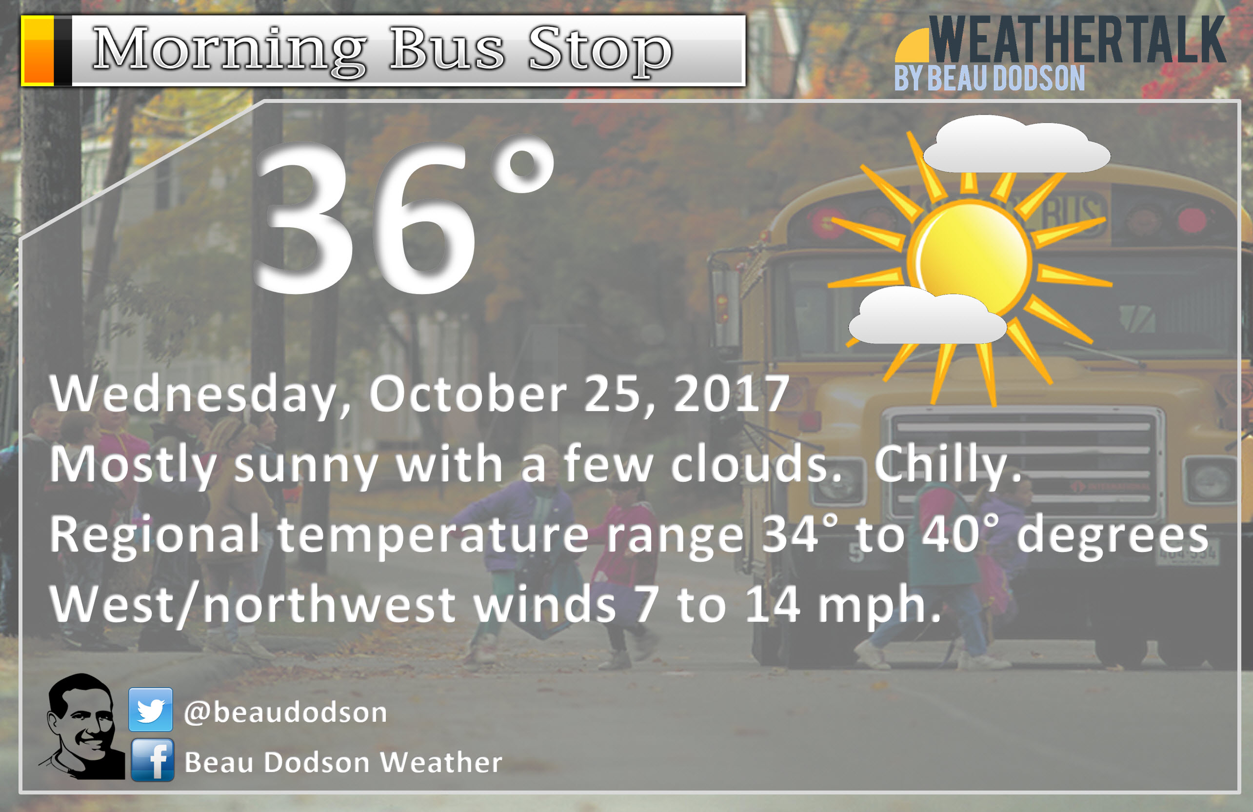
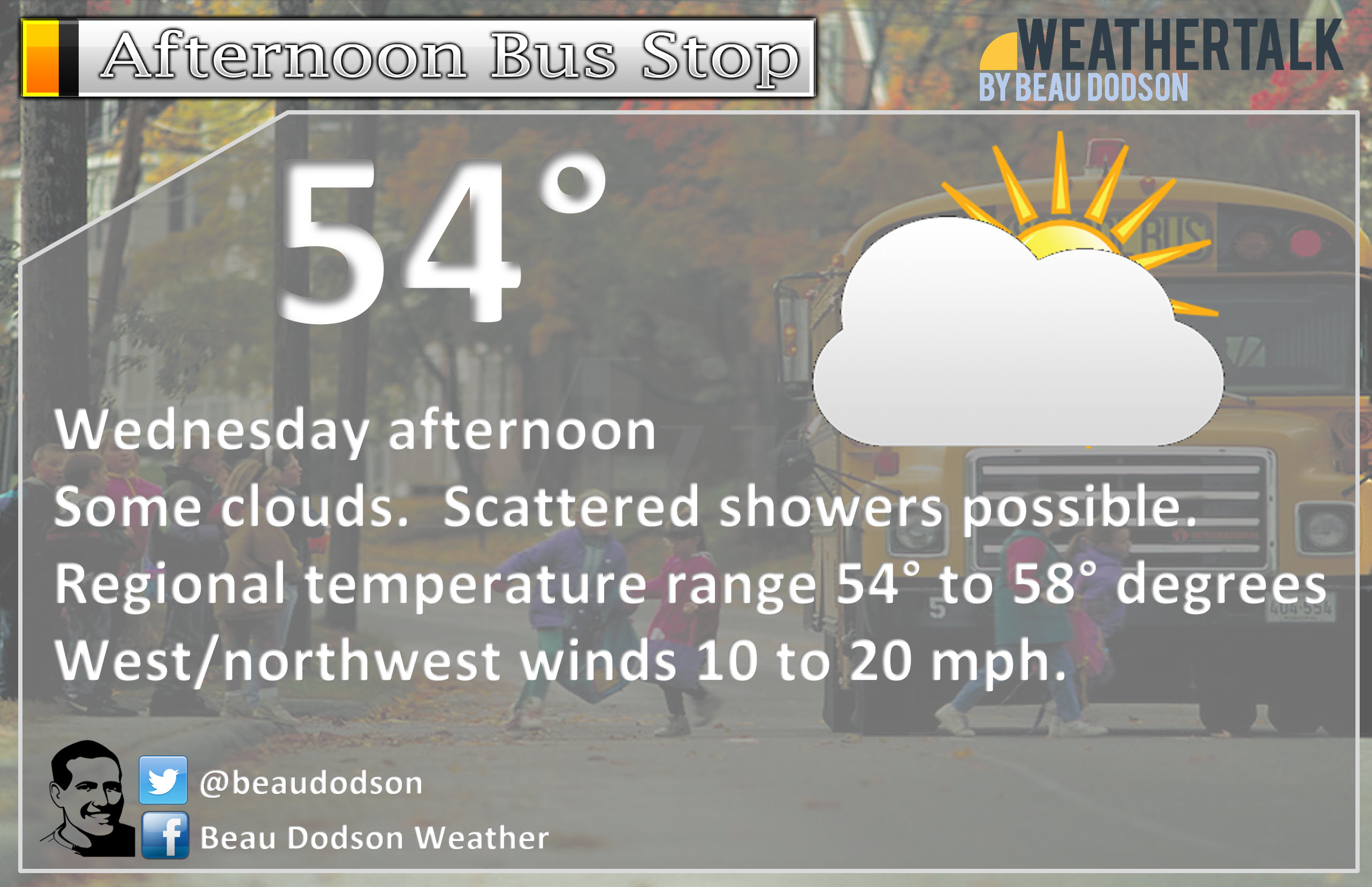
October 25, 2017
Wednesday Forecast Details
Forecast: Increasing clouds during the morning. A light shower possible. Cool. Greatest cloud cover and rain chances will be over southern Illinois and Kentucky.
Temperatures: MO ~ 58 to 64 IL ~ 52 to 58 KY ~ 54 to 58
Winds: West and southwest 6 to 12 mph. Higher gusts possible. Wind variable at times as an upper-level disturbance moves through our region.
What impacts are anticipated from the weather? Perhaps some wet roadways.
My confidence in the forecast verifying: Medium
Is severe weather expected? No
The NWS defines severe weather as 58 mph wind or great, 1″ hail or larger, and/or tornadoes
What is the chance of precipitation? MO ~ 10% IL ~ 30% KY ~ 30%
Coverage of precipitation: Isolated
Should I cancel my outdoor plans? No, but check radars
.
Wednesday Night Forecast Details:
Forecast: Clearing. Cool. Perhaps some patchy frost.
Temperatures: MO ~ 38 to 44 IL ~ 36 to 42 KY ~ 36 to 42
Winds: Variable wind at 4 to 8 mph with gusts to 14 mph
What impacts are anticipated from the weather? Patchy fog and frost possible.
My confidence in the forecast verifying: High
Is severe weather expected? No
The NWS defines severe weather as 58 mph wind or great, 1″ hail or larger, and/or tornadoes
What is the chance of precipitation? MO ~ 0% IL ~ 0% KY ~ 0%
Coverage of precipitation: None
Should I cancel my outdoor plans? No
.
October 26, 2017
Thursday Forecast Details
Forecast: Mostly sunny. A little warmer.
Temperatures: MO ~ 68 to 74 IL ~ 66 to 72 KY ~ 68 to 72
Winds: South and southeast wind 7 to 14 mph with gusts to 18 mph.
What impacts are anticipated from the weather? None
My confidence in the forecast verifying: High
Is severe weather expected? No
The NWS defines severe weather as 58 mph wind or great, 1″ hail or larger, and/or tornadoes
What is the chance of precipitation? MO ~ 0% IL ~ 0% KY ~ 0%
Coverage of precipitation: None
Should I cancel my outdoor plans? No
.
Thursday Night Forecast Details:
Forecast: Increasing clouds through the night. Breezy. A 20% of a shower after 4 am. Not as cold.
Temperatures: MO ~ 45 to 50 IL ~ 45 to 50 KY ~ 45 to 50
Winds: South wind 7 to 14 mph with gusts to 26 mph
What impacts are anticipated from the weather? Maybe some wet roads late at night.
My confidence in the forecast verifying: High
Is severe weather expected? No
The NWS defines severe weather as 58 mph wind or great, 1″ hail or larger, and/or tornadoes
What is the chance of precipitation? MO ~ 30% late IL ~ 20% late KY ~ 20% late
Coverage of precipitation: Perhaps isolated to scattered late at night.
Should I cancel my outdoor plans? No
.
October 27, 2017
Friday Forecast Details
Forecast: Cloudy. Rain developing. A cold front will move through early in the day. Temperatures will fall through the day. Clouds and precipitation possible behind the cold front. A 60% chance of showers.
Temperatures: MO ~ 56 to 62 IL ~ 56 to 62 KY ~ 60 to 64 Falling temperatures as we move through the day.
Winds: Variable wind 7 to 14 mph. Winds becoming west/northwest at 8 to 16 mph.
What impacts are anticipated from the weather? Wet roadways.
My confidence in the forecast verifying: Medium
Is severe weather expected? No
The NWS defines severe weather as 58 mph wind or great, 1″ hail or larger, and/or tornadoes
What is the chance of precipitation? MO ~ 60% IL ~ 60% KY ~ 60%
Coverage of precipitation: Perhaps numerous.
Should I cancel my outdoor plans? Have a plan B.
.
Friday Night Forecast Details:
Forecast: Cloudy early. Rain showers perhaps mixed with snow showers will come to an end. Turning colder. Frost possible if the wind subsides. If snow were to occur it would likely be just a novelty and should not stick.
Temperatures: MO ~ 34 to 38 IL ~ 34 to 38 KY ~ 35 to 40
Winds: Northwest wind 8 to 16 mph early and then 6 to 12 mph late
What impacts are anticipated from the weather? Evening wet roadways. Perhaps scattered frost where the wind subsides. Valleys, as well.
My confidence in the forecast verifying: Medium
Is severe weather expected? No
The NWS defines severe weather as 58 mph wind or great, 1″ hail or larger, and/or tornadoes
What is the chance of precipitation? MO ~ 30% IL ~ 40% early KY ~ 40% early
Coverage of precipitation: Scattered, but ending from west to east.
Should I cancel my outdoor plans? No, but check radars early in the night.
.
October 28, 2017
Saturday Forecast Details
Forecast: Mostly sunny and cool.
Temperatures: MO ~ 48 to 54 IL ~ 48 to 54 KY ~ 50 to 55
Winds: North and northwest wind at 5 to 10 mph.
What impacts are anticipated from the weather? None
My confidence in the forecast verifying: High
Is severe weather expected? No
The NWS defines severe weather as 58 mph wind or great, 1″ hail or larger, and/or tornadoes
What is the chance of precipitation? MO ~ 0% IL ~ 0% KY ~ 0%
Coverage of precipitation: None
Should I cancel my outdoor plans? No
.
Saturday Night Forecast Details:
Forecast: Mostly clear. Cold. Frost or freeze likely.
Temperatures: MO ~ 28 to 34 IL ~ 28 to 34 KY ~ 30 to 35
Winds: Light wind.
What impacts are anticipated from the weather? Frost or freeze possible.
My confidence in the forecast verifying: Medium
Is severe weather expected? No
The NWS defines severe weather as 58 mph wind or great, 1″ hail or larger, and/or tornadoes
What is the chance of precipitation? MO ~ 0% IL ~ 0% KY ~ 0%
Coverage of precipitation: None
Should I cancel my outdoor plans? No
.
October 28, 2017
Sunday Forecast Details
Forecast: Mostly sunny and cool.
Temperatures: MO ~ 50 to 55 IL ~ 50 to 55 KY ~ 52 to 56
Winds: Variable wind at 5 to 10 mph.
What impacts are anticipated from the weather? None
My confidence in the forecast verifying: High
Is severe weather expected? No
The NWS defines severe weather as 58 mph wind or great, 1″ hail or larger, and/or tornadoes
What is the chance of precipitation? MO ~ 0% IL ~ 0% KY ~ 0%
Coverage of precipitation: None
Should I cancel my outdoor plans? No
.
Sunday Night Forecast Details:
Forecast: Mostly clear. Cold. Frost or freeze likely.
Temperatures: MO ~ 28 to 34 IL ~ 28 to 34 KY ~ 30 to 35
Winds: Light wind.
What impacts are anticipated from the weather? Frost or freeze possible.
My confidence in the forecast verifying: Medium
Is severe weather expected? No
The NWS defines severe weather as 58 mph wind or great, 1″ hail or larger, and/or tornadoes
What is the chance of precipitation? MO ~ 0% IL ~ 0% KY ~ 0%
Coverage of precipitation: None
Should I cancel my outdoor plans? No
I am monitoring November 2nd and 3rd for a storm system.
.
.

The National Weather Service definition of a severe thunderstorm is one that produces quarter size hail or larger, 58 mph winds or greater, and/or a tornado.
Tuesday through Monday: No severe weather concerns.

Weather Highlights:
The December outlook has been updated on the long-range subscriber page. You can view that by subscribing at www.beaudodsonweather.com
Once you subscribe you can see every update by clicking on the Severe Weather Outlook tab. That will take you to the daily links. Look for the long-range outlook link.
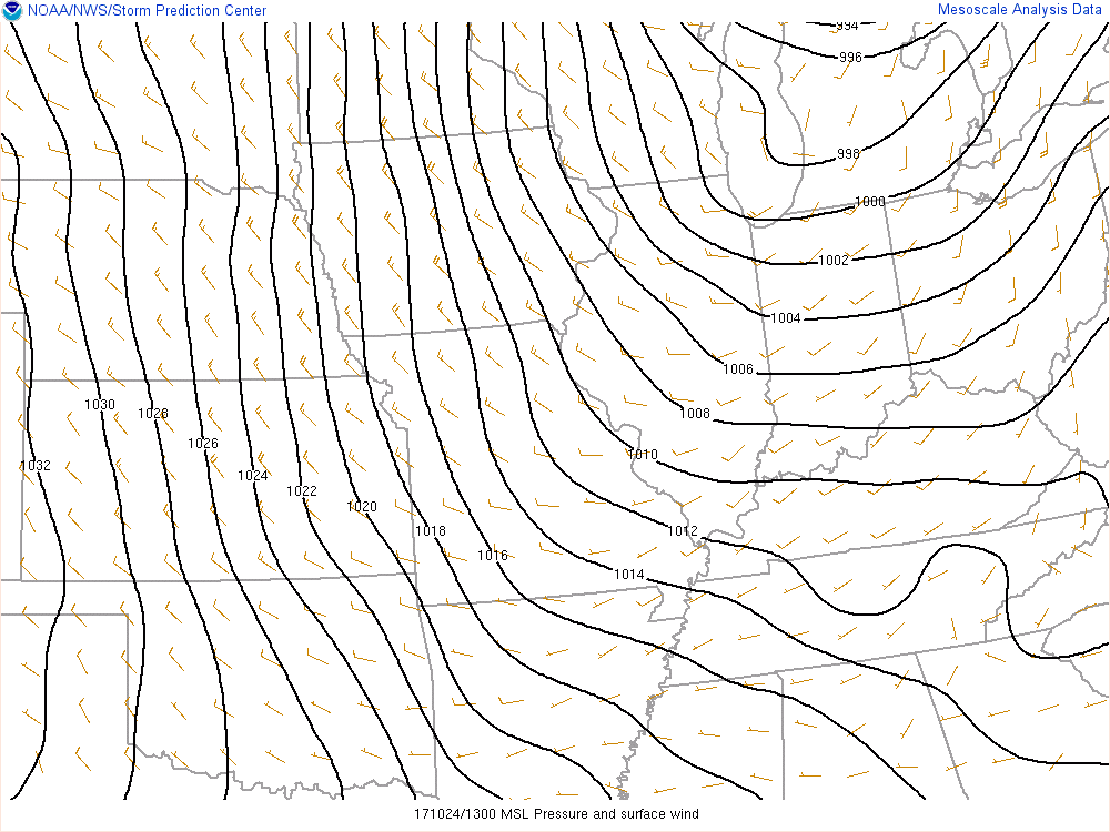
Tuesday was a cool day with strong and gusty winds.
The tight pressure gradient was responsible for the gusty winds. The area of low pressure was centered over the Great Lakes. Winds gusted over 30 mph in our local area.
Here was the Tuesday 9 am isobar map. Isobars are equal lines of pressure.
Just look at how tightly packed those lines are. That is always a good indicator of strong and gusty winds. Winds in the great lakes actually topped 50 mph.
Tightly packed isobars represent rapidly rising or falling barometric pressure readings.
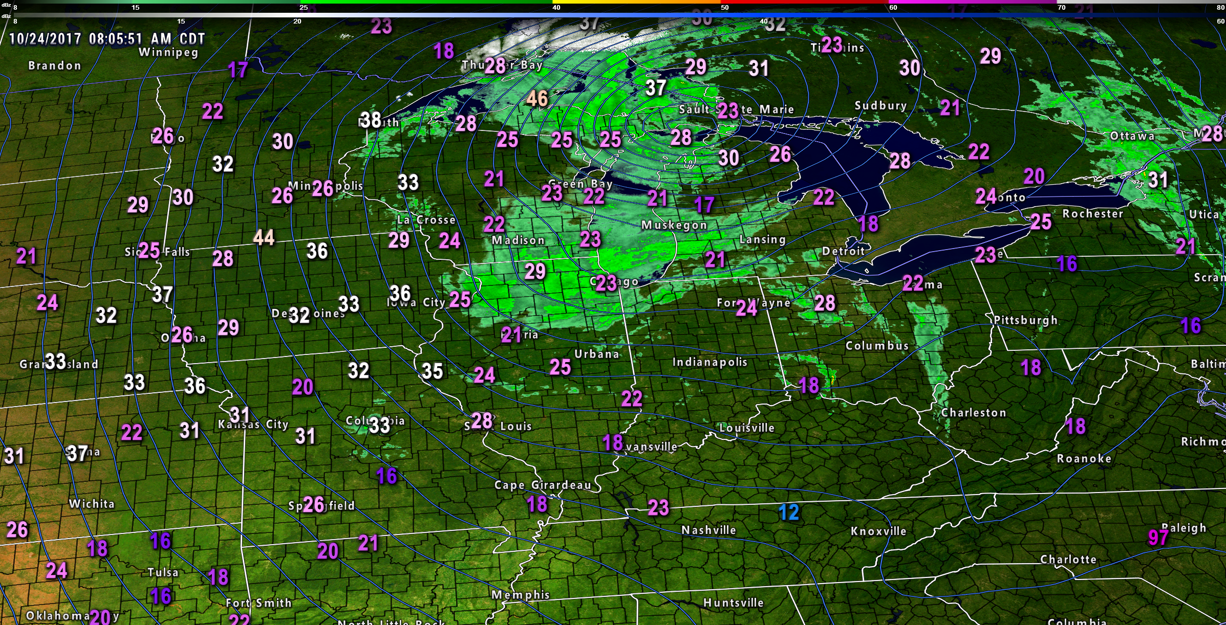
The wind gust map from 8 am Tuesday morning. The numbers are the wind gusts. Green was rain. White (northern Great Lakes) was snow.
Click to enlarge
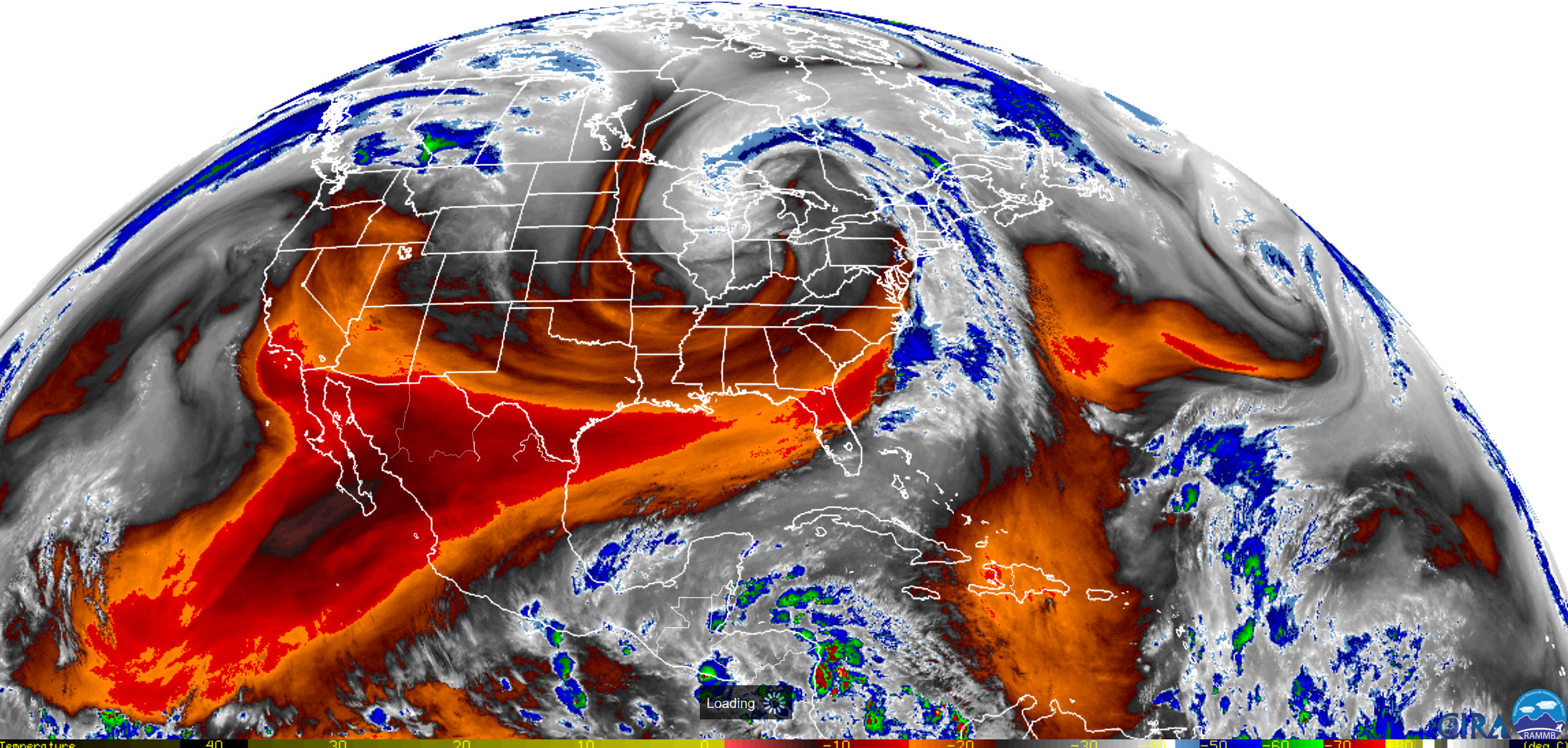
This system had a beautiful satellite presentation. A mid-latitude cyclone. Here are some satellite images from Tuesday morning. A very large system. It extended all the way back into the Pacific Ocean.
Click images to enlarge
Notice the comma shape.
Wednesday
That system will continue to influence our region into Wednesday night.
Wednesday morning will be chilly with patchy frost possible. Frost is more likely if winds subside and clouds depart.
A fast-moving disturbance will bring some additional clouds on Wednesday. I can’t rule out some flight showers, as well. The best chance of that occurring would be over southern Illinois and western Kentucky. I will cap rain chances at 40%. That means there will likely be showers on the radar, but many areas may remain dry.
Rainfall totals would be less than 0.15″.
The NWS is not forecasting clouds or rain for Wednesday. Thus, there is some disagreement on this topic.
It will continue to be windy on Wednesday. Gusts will likely top 20 mph from time to time.
Wednesday morning temperatures will likely be in the 30’s. The frost potential is not zero. The winds will help mitigate widespread frost. If the winds were to subside then frost would likely form.
As it stands, the frost risk is medium. Areas protected from the wind may have frost.
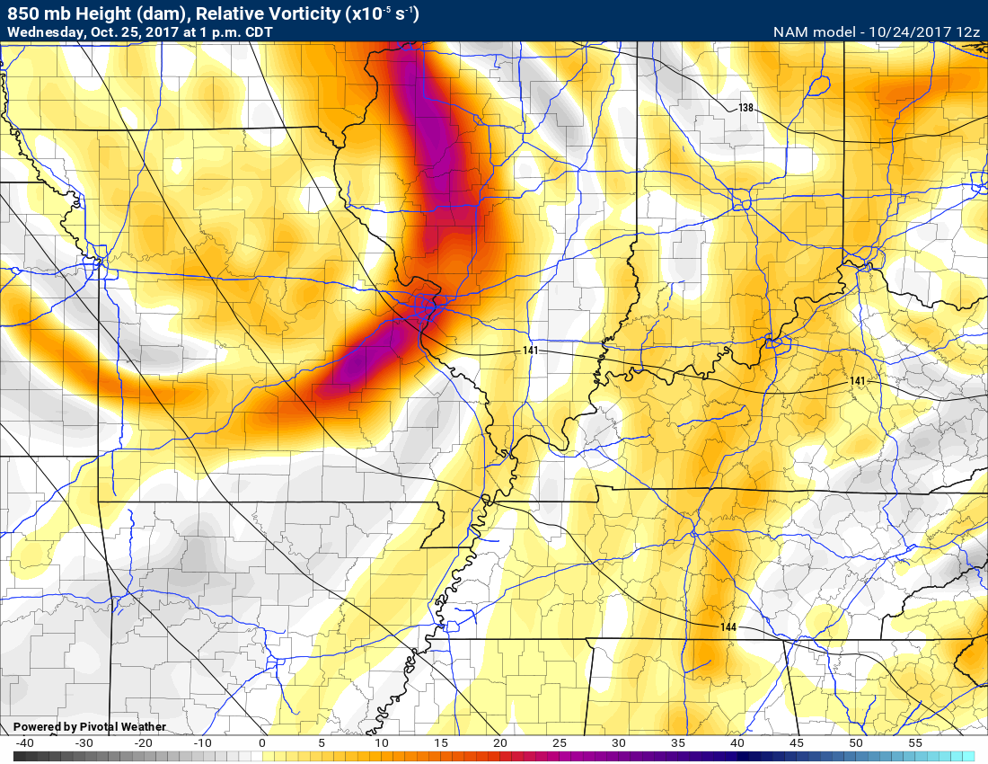
Here is that fast-moving Wednesday system on the upper-level charts. Those bright red areas are the disturbance that will move from the northwest towards the southeast on Wednesday.
850 MB vorticity chart. See the bowing colors? That is the disturbance. It should have enough moisture to set off some clouds and maybe a light shower or two. This would primarily be from the late Wednesday morning hours into the afternoon.
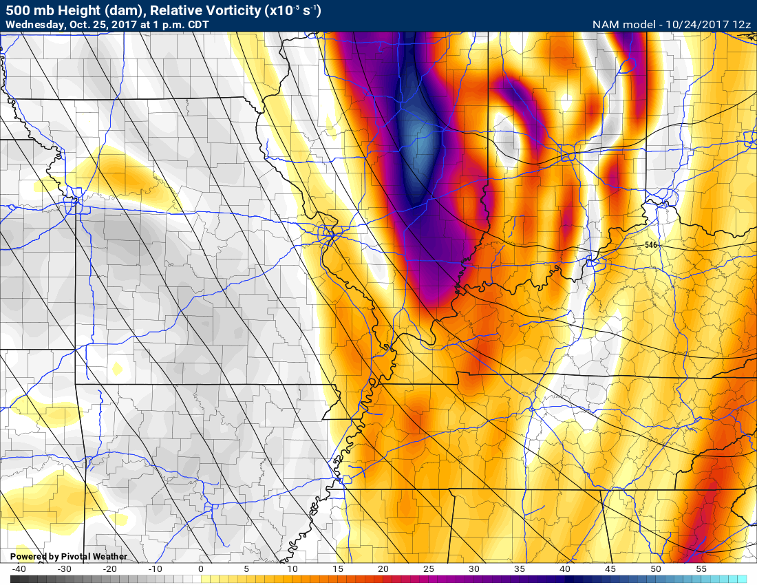
The 500 mb vorticity map shows it even better. The higher numbers are over Indiana. The colors represent areas of positive vorticity. In theory, that is where the air would be rising and clouds would occur. Perhaps precipitation, as well.
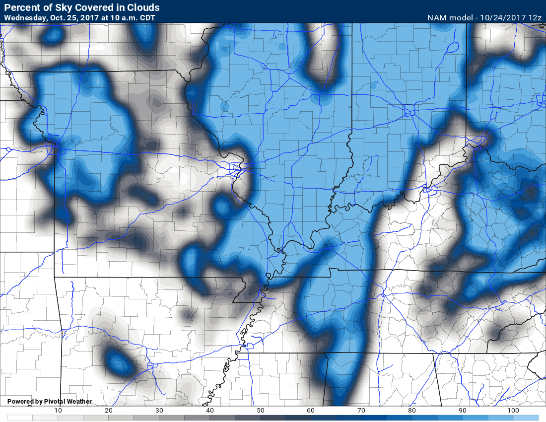
The cloud forecast chart shows the clouds moving through on Wednesday.
Blue represents clouds.
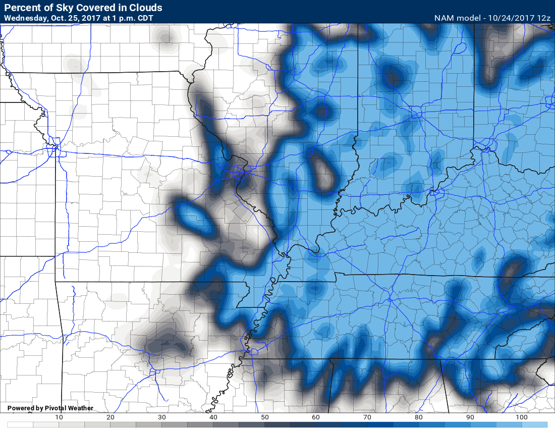
10 am Wednesday. Clouds moving through our region.
1 pm Wednesday. Clouds continue to push south and east.
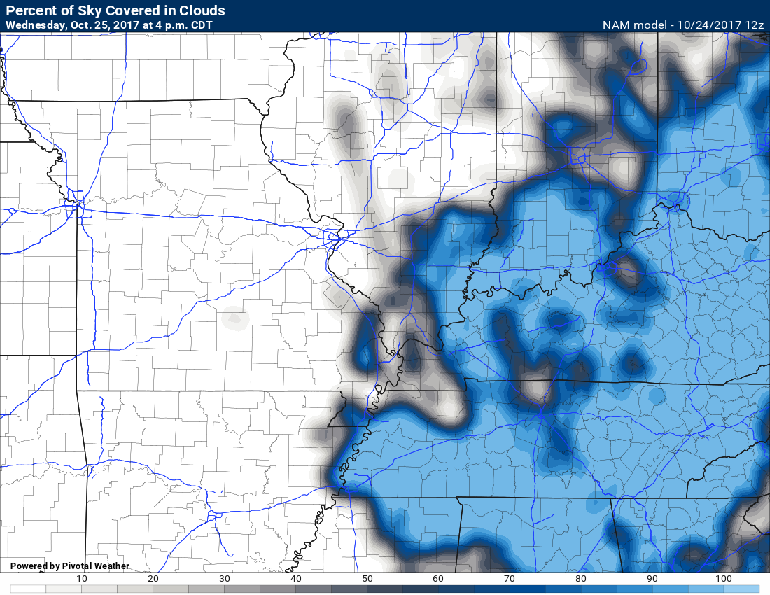
4 pm Wednesday
Clouds pushing off to the southeast.
Thursday
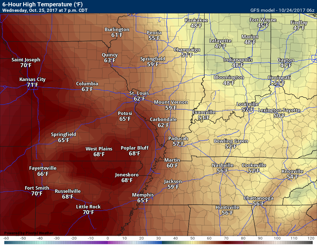
We will see temperatures moderate a little bit on Thursday. I am forecasting highs from 65 to 70 degrees. I can’t rule out lower 70’s. I will monitor trends. The best chance of lower 70’s would be over southeast Missouri.
Thursday high temperatures
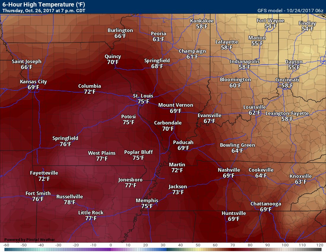
Dry weather is anticipated for Thursday and probably Thursday night, as well.
Rain chances increase on Friday.
Long range forecast discussion
Another cold front will push through the region on Friday. This front will deliver the coldest air of the season, thus far.
A band of showers will likely develop along and behind the front. We call this an ana-front.
An ana front is a frontal boundary in which the main shield of clouds and precipitation is located behind the actual frontal boundary.
This is because cold air located behind the front moves rapidly, pushing against the warm air out ahead of the front. Because cold air is denser than warm air, the surging cold air causes the warm air to lift upward along the front.
There remain some questions about how much rain will fall on Friday. Guidance has been swinging from no rain at all to over an inch.
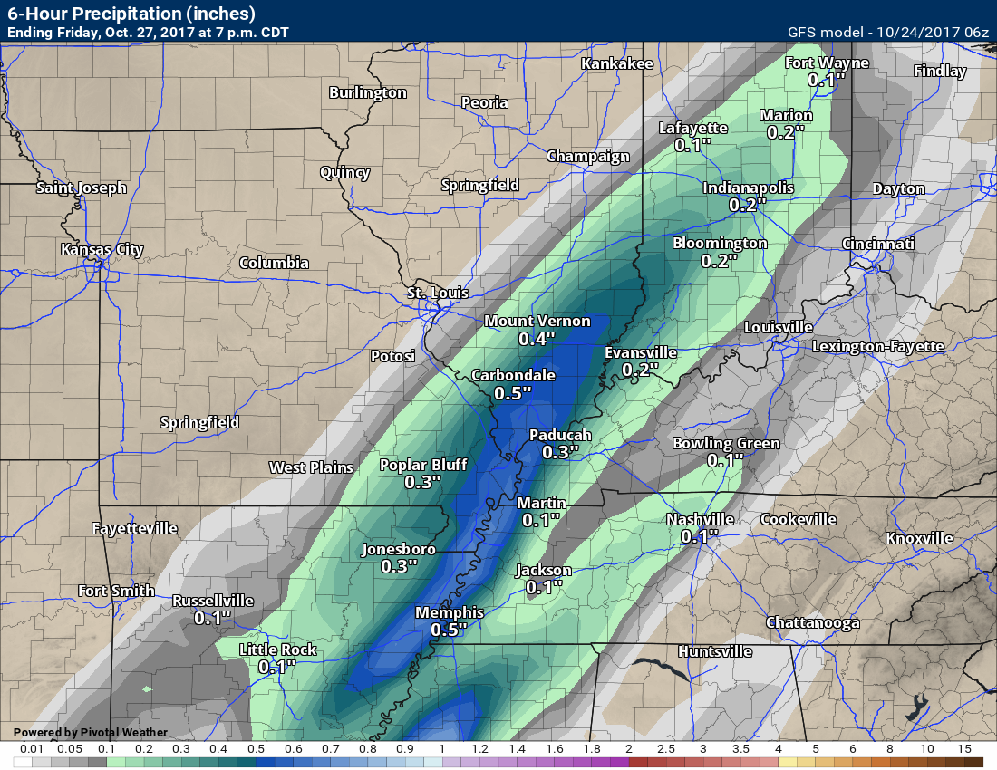
Here is what the GFS model guidance is forecasting for six-hour rainfall totals.
This first image is from 7 am Friday until 1 pm Friday. The second image is 1 pm Friday unitl 7 pm Friday.
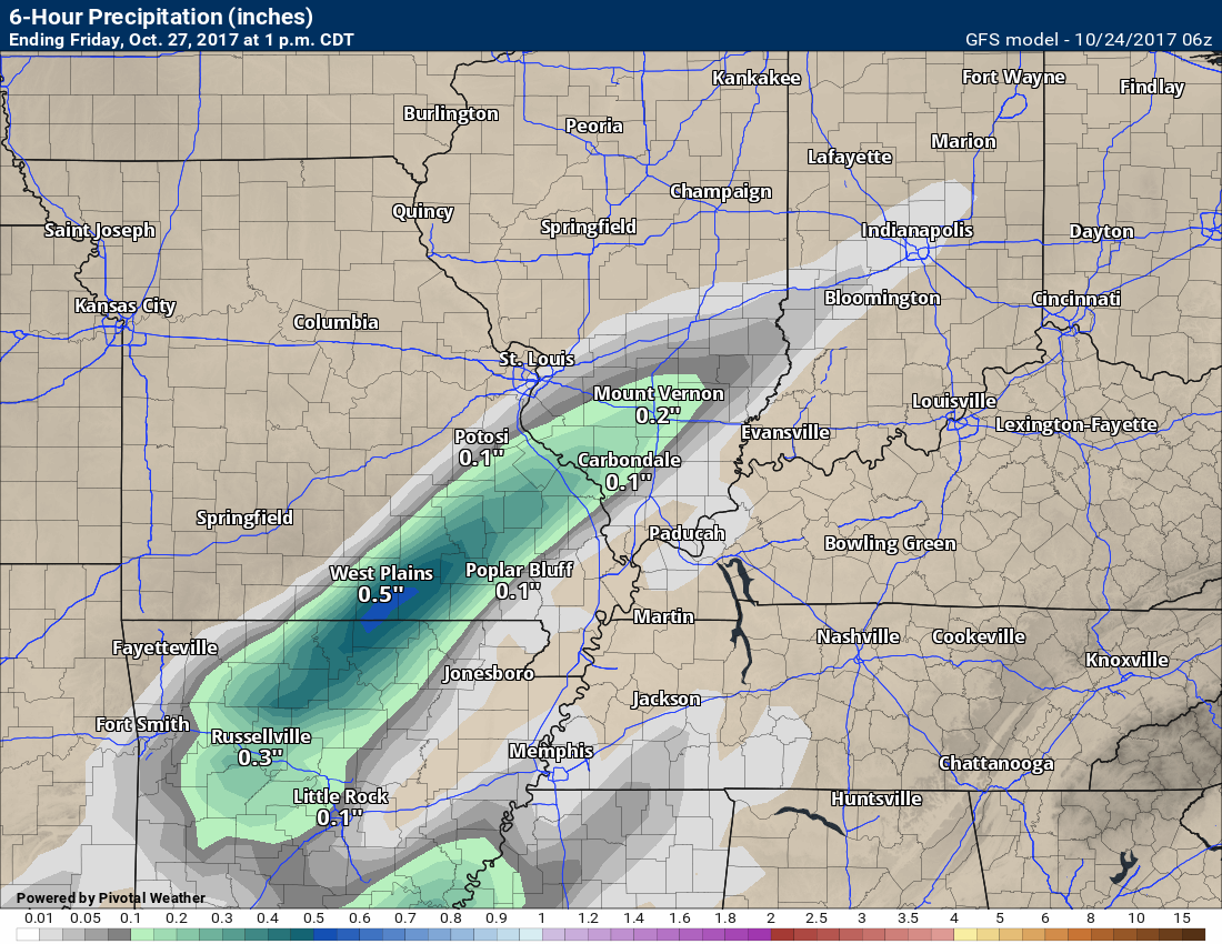
and
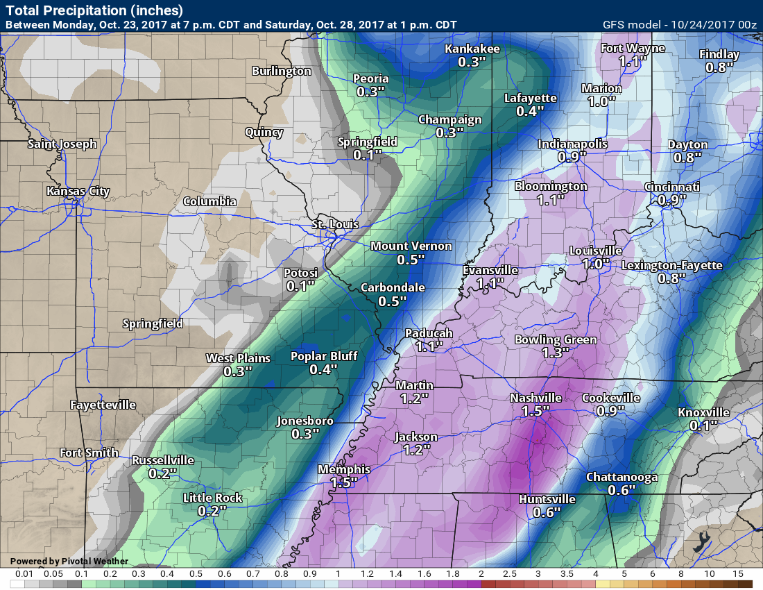
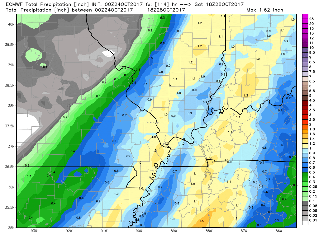
Here is the total rainfall forecast from the GFS. The GFS showed no rain at all on yesterday’s data. This is a big shift. It is also a shift towards what the EC guidance has been forecasting. EC has been wetter for Friday vs the GFS model guidance.
GFS forecast rainfall totals for Friday
EC model guidance rainfall totals for Friday.
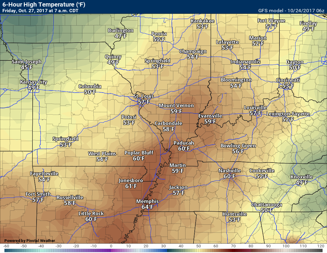
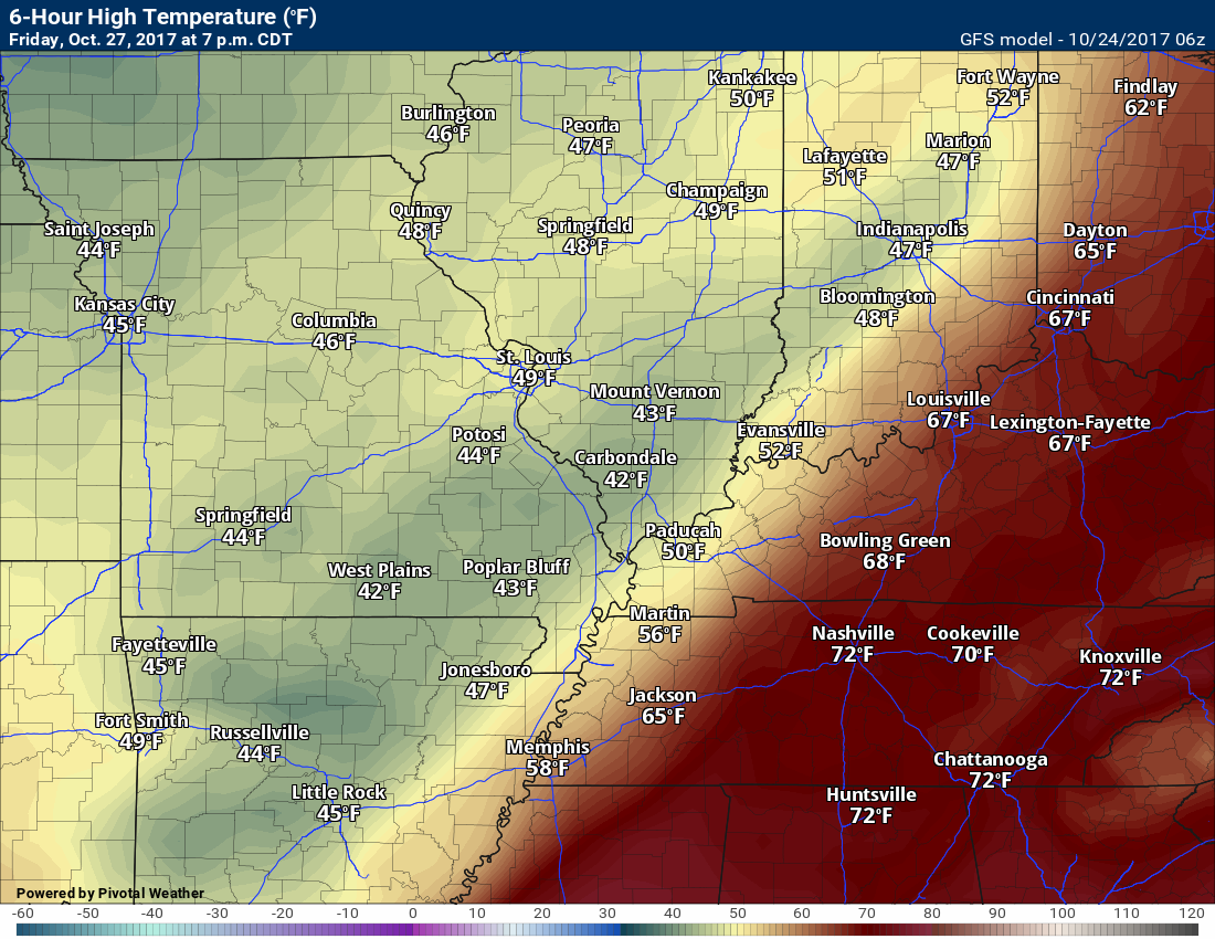
Temperatures on Friday may actually fall during the day. This will occur as the front moves through the area.
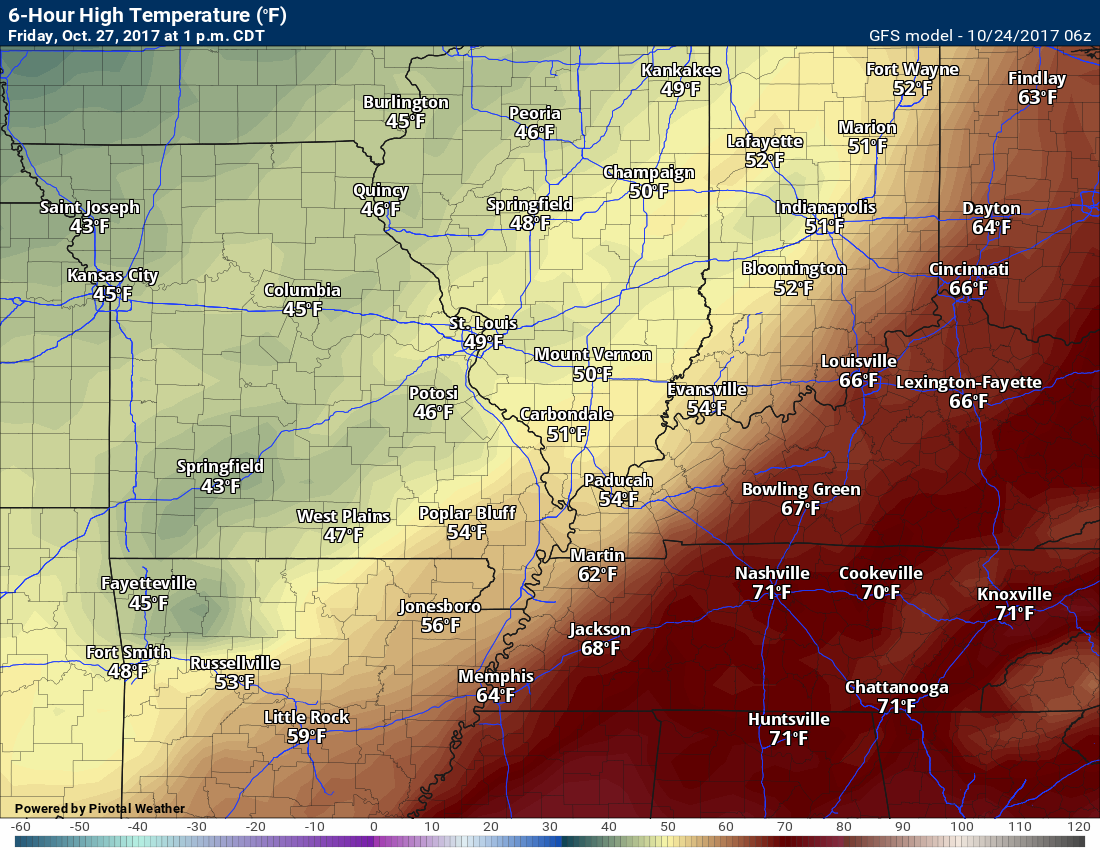
7 AM Friday temperatures
1 pm Friday temperatures (notice they are cooler)
7 pm Friday temperatures. Can you find the front?
Frost Forecast
The next question is whether we have a frost or freeze this coming weekend. Perhaps both.
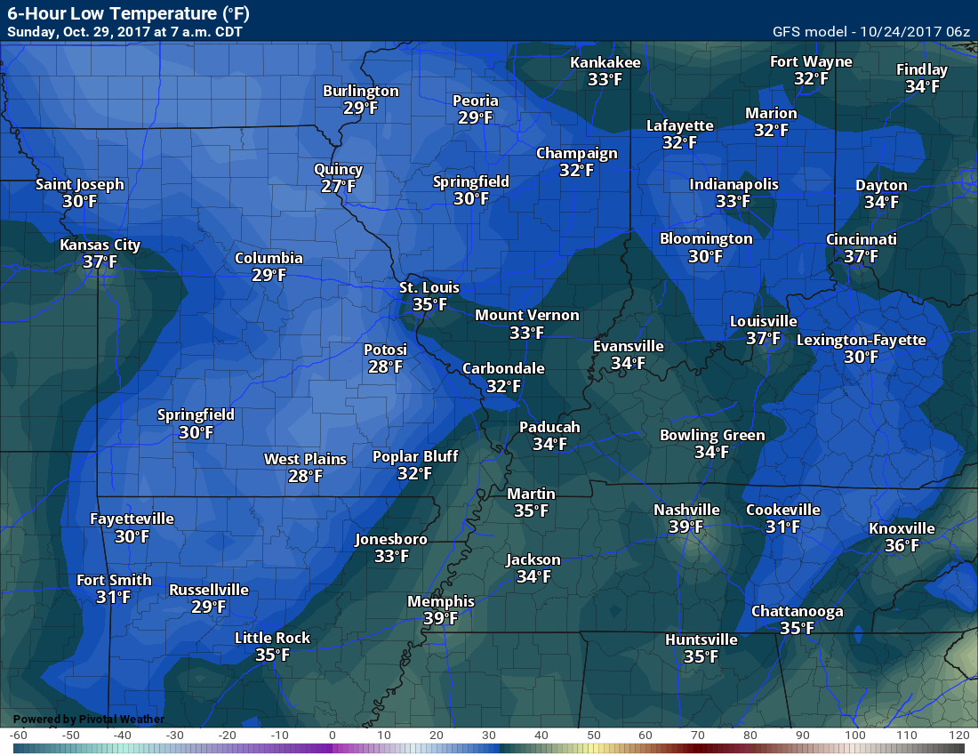
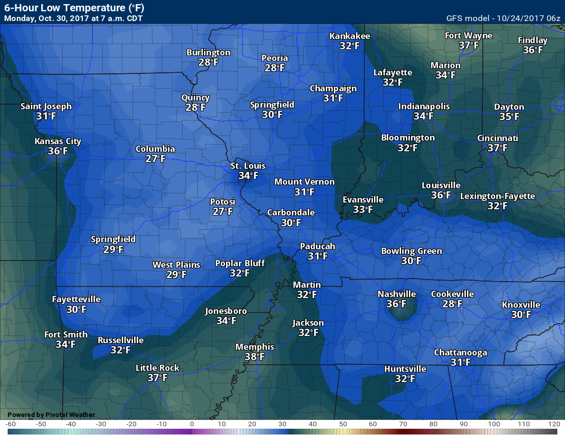
Analog forecasting shows high probabilities of 32 degrees or below Saturday, Sunday, and Monday morning. I am leaning more towards Sunday and Monday morning for the coldest readings.
This map shows 80%+ odds for temperatures to fall to 32 degrees or colder this weekend.
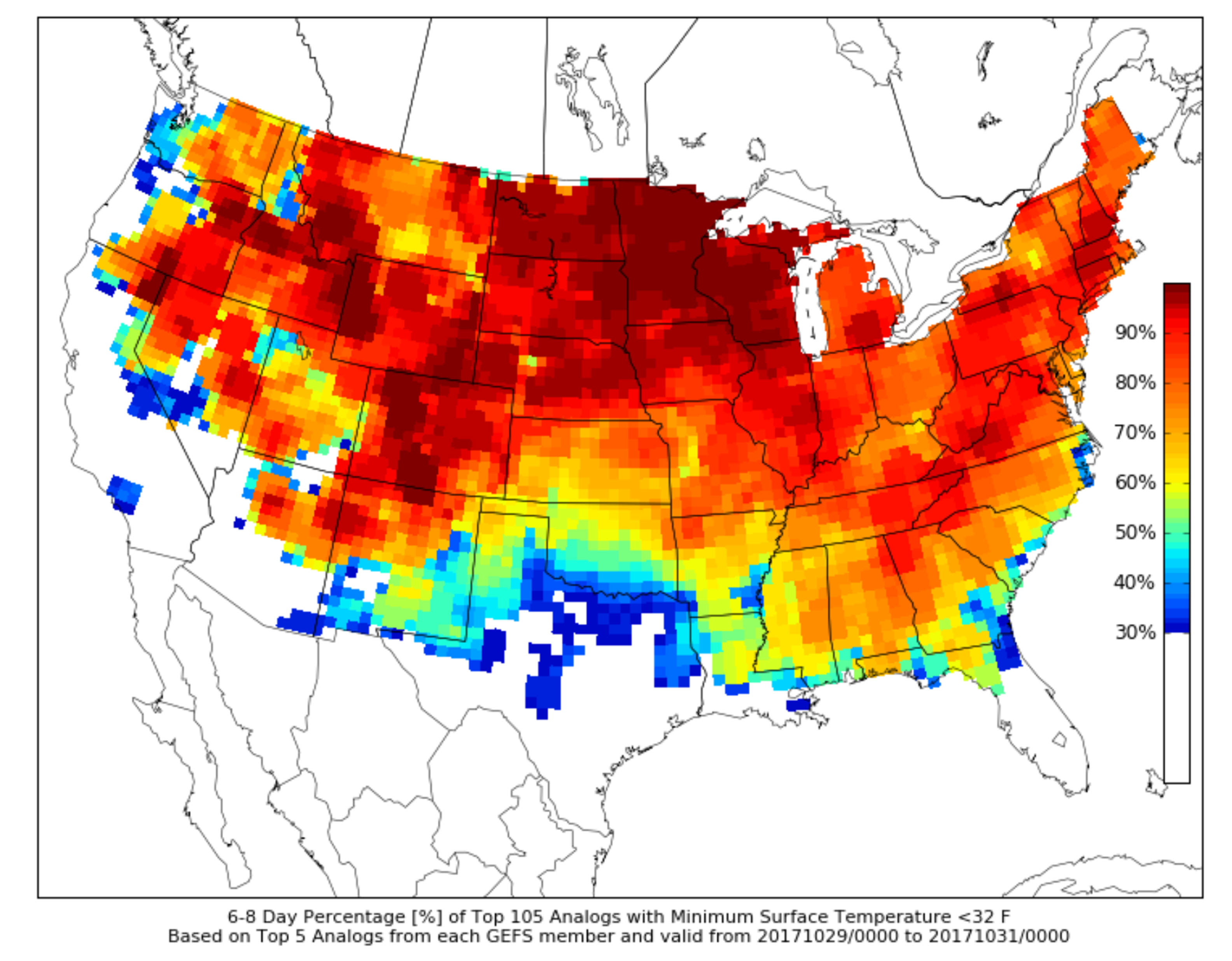
Odds are favoring Sunday or Monday morning to dip to 32 degrees or colder.
Friday nights frost risk will be highly dependent on cloud cover and winds. If clouds linger and if winds remain gusty, then frost is unlikely to form.
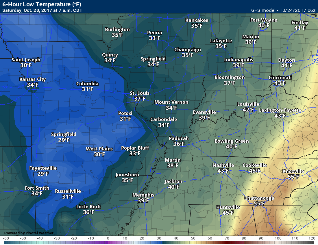
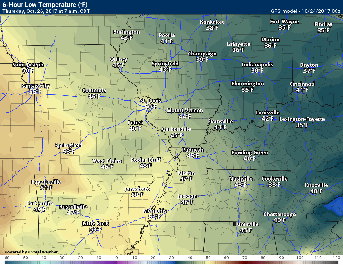
Saturday morning GFS low-temperature forecast
Sunday morning low-temperature forecast
Monday morning low-temperature forecast
Dry weather is likely Saturday and Sunday.
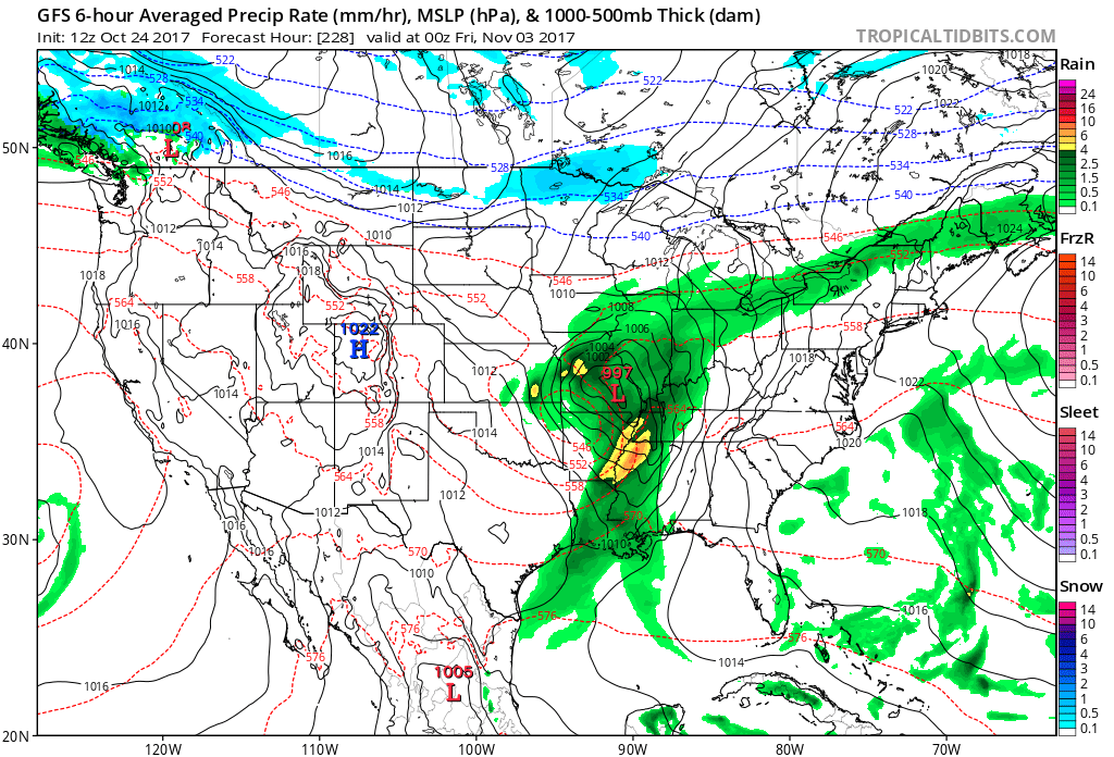
I am watching another cold front for next week. Perhaps centered around the 2nd or 3rd.
See the long-range discussion on the subscriber page for more information on the temperature and precipitation forecasts. You can view that here. Click here.
Temperature Forecast
Tuesday night low temperatures
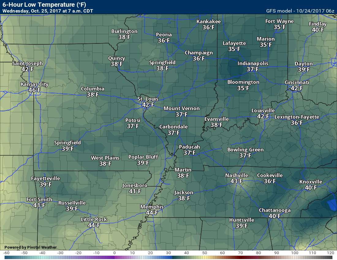
Wednesday high temperatures
Wednesday night low temperatures
.
Are you subscribing to Weather Talk app/text messages and videos? This is what helps support all of the data you see each day.
We now offer premium videos for the short and long-range forecasts! These videos are produced by a team of long-range forecast experts. They are brought to you as bonus information. Activate text option four in order to receive these on your app or via text.
Subscribe at www.beaudodsonweather.com
We offer an Apple and Android app (scroll to the bottom of this page for more information).

Were you aware that I hired a team of meteorologists for long range videos?
To learn more, click this link
http://cms.weathertalk.com/meet-the-team/
.


We offer regional radars and local city radars – if a radar does not update then try another one. Occasional browsers need their cache cleared. You may also try restarting your browser. This will usually fix any problems.
During the winter you can track snow and ice by clicking the winterize button on the local city view interactive radars.
You may email me at beaudodson@usawx.com
Interactive Weather Radar Page. Choose the city nearest your location: Click this link
National interactive radar: Click this link.
The Beau Dodson Weather APP is ready for Apple and Android users. The app provides a faster way for you to receive my text messages. ATT and Verizon are not always reliable when it comes to speed.
Some of you have asked if you can receive the texts on your phone and the app. The answer to that is, yes. The Android app will automatically allow that to happen. On the Apple app, however, you will need to open your app and click the settings button. Make sure the green tab is OFF. Off means you will still receive the texts to your phone and the app. If you have any questions, then email me at beaudodson@usawx.com
The app is for text subscribers.
The direct download, for the Apple app, can be viewed here
https://itunes.apple.com/us/app/id1190136514
Here is the download link for the Android version Click Here
If you have not signed up for the texting service then you may do so at www.beaudodsonweather.com


——————————————————–
Your support helps with the following:

and

.

Whom do you trust for your weather information?
I have studied weather, in our region, since the late 1970’s. I have 40 years of experience in observing our regions weather patterns. My degree is in Broadcast Meteorology and a Bachelor’s of Science.
My resume includes:
Member of the American Meteorological Society.
NOAA Weather-Ready Nation Ambassador.
Meteorologist for McCracken County Emergency Management. I served from 2005 through 2015.
Meteorologist for McCracken County Rescue. 2015 through current
I own and operate the Southern Illinois Weather Observatory.
I am the chief meteorologist for Weather Talk LLC.
I am also a business owner in western Kentucky.
Recipient of the Mark Trail Award, WPSD Six Who Make A Difference Award, Kentucky Colonel, and the Caesar J. Fiamma” Award from the American Red Cross.
In 2005, I helped open the largest American Cross shelter in U.S. history. This was in Houston, Texas. I was deployed to help with the aftermath of Hurricane Katrina and Hurricane Rita. I was a shelter manager of one of the Houston, Texas shelter divisions.
In 2009 I was presented with the Kentucky Office of Highway Safety Award.
Recognized by the Kentucky House of Representatives for my service to the State of Kentucky leading up to several winter storms and severe weather outbreaks.
If you click on the image below you can read the Kentucky House of Representatives Resolution.

I am President of the Shadow Angel Foundation which serves portions of western Kentucky and southern Illinois.
There is a lot of noise on the internet. A lot of weather maps are posted without explanation. You need a trusted source for information.
My forecast philosophy is simple and straight forward.
- Communicate in simple terms
- To be as accurate as possible within a reasonable time frame before an event
- Interact with you on Twitter, Facebook, email, texts, and this blog
- Minimize the “hype” that you might see through other weather sources
- Push you towards utilizing wall-to-wall LOCAL TV coverage during severe weather events

Sign up for my AWARE email by clicking here.
I typically send AWARE emails before severe weather, winter storms, or other active weather situations. I do not email watches or warnings. The emails are a basic “heads up” concerning incoming weather conditions