

.
A Weather Talk subscription ($3 a month) is required to view the videos. This helps cover monthly costs (which can run between one and two thousand dollars).
Videos are posted on the www.weathertalk.com website. Once there, click the Beau Video-Cast tab. Long Range Video Update
If you believe you missed a video then you may check the LIVE FEED link on the Weather Talk website. You will find an archive of videos on that page.
You can also receive the videos via your Weather Talk app/text messages. Turn text option FOUR to the on position. The Weather Extra text option. Sign up for the app/text messages, videos, and more at www.beaudodsonweather.com
.
This forecast covers the counties in red. The counties in orange are covered by the forecast discussion further down in the blog.


.
October 22, 2017
Sunday Night Forecast Details:
Forecast: Cloudy. Rain showers likely. Some locally heavy downpours are possible. Rain coverage may be greater over Illinois and Kentucky vs Missouri. This will partly depend on the track of the upper-level storm system approaching from the southwest. Cool temperatures. Gusty winds from time to time.
Temperatures: MO ~ 50 to 55 IL ~ 50 to 55 KY ~ 52 to 56
Winds: Variable winds at 6 to 12 mph. Gusty winds possible from time to time.
What impacts are anticipated from the weather? Wet roadways. Isolated lightning possible.
My confidence in the forecast verifying: Medium
Is severe weather expected? No
The NWS defines severe weather as 58 mph winds or great, 1″ hail or larger, and/or tornadoes
What is the chance of precipitation? MO ~ 60% IL ~ 70% KY ~ 80%
Coverage of precipitation: Numerous to perhaps widespread. Greatest coverage over Illinois and Kentucky.
Should I cancel my outdoor plans? Have a plan B.
.
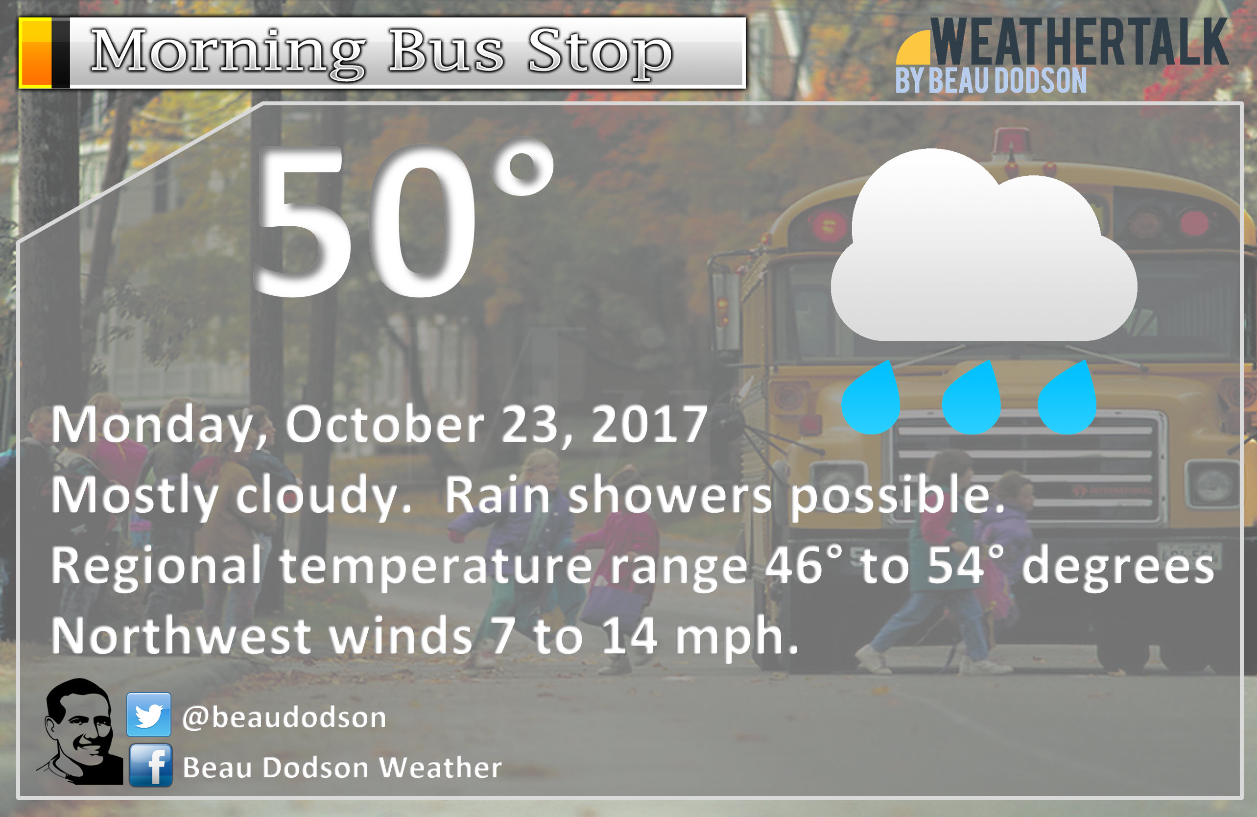
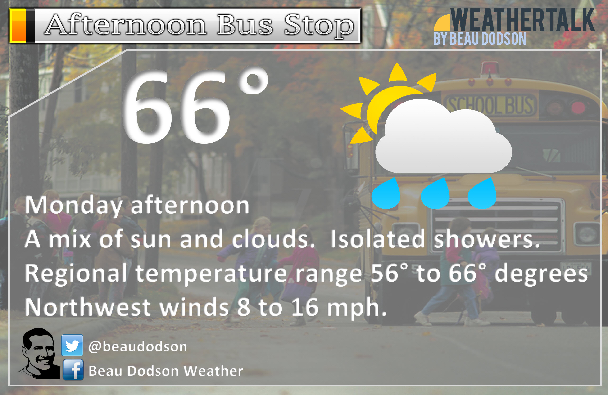
October 23, 2017
Monday Forecast Details
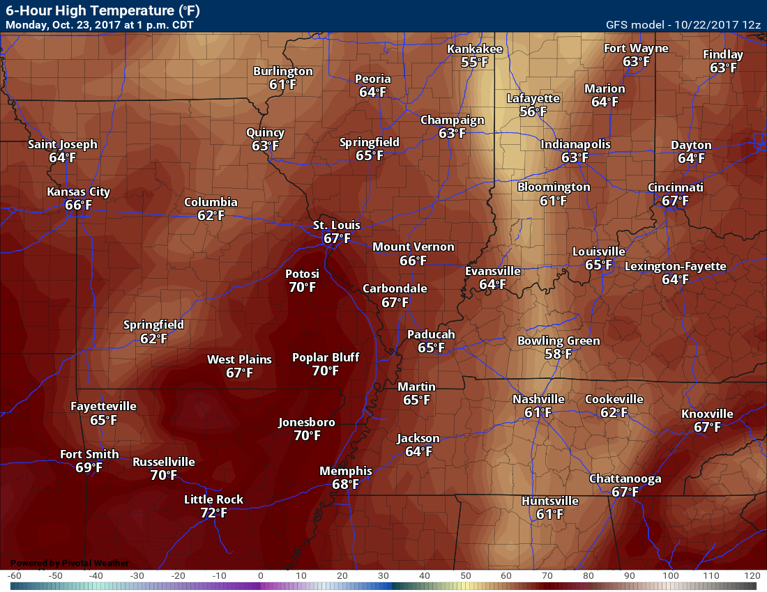
Forecast: Morning clouds. Some showers possible over southern Illinois and western Kentucky. A mix of sun and clouds during the afternoon hours. Cooler.
Temperatures: MO ~ 65 to 70 IL ~ 62 to 66 KY ~ 62 to 66
Winds: North and northwest at 8 to 16 mph with gusts to 25 mph.
What impacts are anticipated from the weather? Wet roadways.
My confidence in the forecast verifying: Medium
Is severe weather expected? No
The NWS defines severe weather as 58 mph winds or great, 1″ hail or larger, and/or tornadoes
What is the chance of precipitation? MO ~ 30% IL ~ 50% (mostly early in the day) KY ~ 60% (early)
Coverage of precipitation: Scattered. Greater coverage over our eastern counties vs western.
Should I cancel my outdoor plans? Have a plan B, especially Illinois and Kentucky.
.
Monday Night Forecast Details:
Forecast: Partly cloudy. Cooler. A slight chance of showers late tonight for southern Illinois and northwest Kentucky. Breezy.
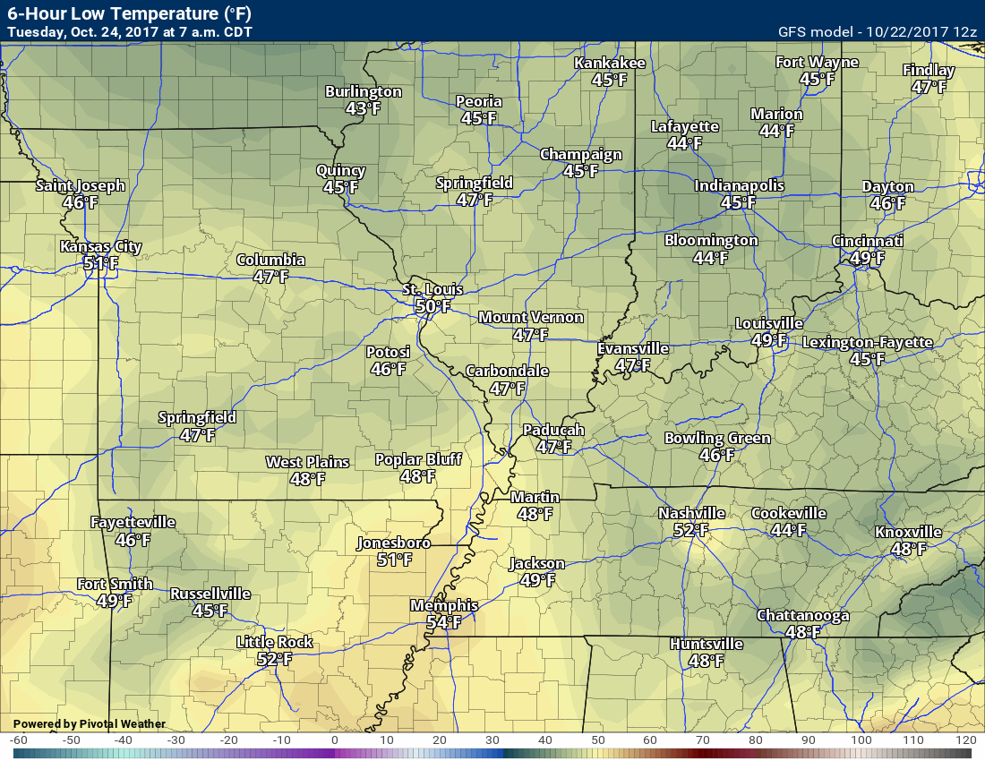
Temperatures: MO ~ 43 to 46 IL ~ 43 to 46 KY ~ 43 to 46
Winds: Northwest winds 7 to 14 mph with gusts to 25 mph.
What impacts are anticipated from the weather? Perhaps patchy fog. Perhaps a few wet roadways.
My confidence in the forecast verifying: Medium
Is severe weather expected? No
The NWS defines severe weather as 58 mph winds or great, 1″ hail or larger, and/or tornadoes
What is the chance of precipitation? MO ~ 10% IL ~ 30% KY ~ 20%
Coverage of precipitation: None to isolated.
Should I cancel my outdoor plans? No
.
October 24, 2017
Tuesday Forecast Details
Forecast: Breezy. A mix of sun and clouds (greatest cloud cover would be over southern Illinois and northwest Kentucky). Isolated showers (mainly over southern Illinois). Cooler.
Temperatures: MO ~ 55 to 60 IL ~ 55 to 60 KY ~ 55 to 60
Winds: West and northwest at 12 to 24 mph with higher gusts.
What impacts are anticipated from the weather? Perhaps wet roadways
My confidence in the forecast verifying: High
Is severe weather expected? No
The NWS defines severe weather as 58 mph winds or great, 1″ hail or larger, and/or tornadoes
What is the chance of precipitation? MO ~ 0% IL ~ 20% KY ~ 20%
Coverage of precipitation: Isolated for southern Illinois and northwest Kentucky.
Should I cancel my outdoor plans? No
.
Tuesday Night Forecast Details:
Forecast: Partly cloudy early and then clearing. Colder. If the winds subside then a chance of frost. A small chance of an evening shower over southeast Illinois and northwest Kentucky.
Temperatures: MO ~ 36 to 42 IL ~ 36 to 42 KY ~ 38 to 44
Winds: Northwest winds at 8 to 16 mph with higher gusts possible early in the night.
What impacts are anticipated from the weather? Perhaps patchy frost.
My confidence in the forecast verifying: Medium
Is severe weather expected? No
The NWS defines severe weather as 58 mph winds or great, 1″ hail or larger, and/or tornadoes
What is the chance of precipitation? MO ~ 10% IL ~ 10% KY ~ 10%
Coverage of precipitation: None
Should I cancel my outdoor plans? No
.
October 25, 2017
Wednesday Forecast Details
Forecast: Mostly sunny. A few passing clouds. Cool temperatures.
Temperatures: MO ~ 55 to 60 IL ~ 55 to 60 KY ~ 55 to 60
Winds: West and southwest 6 to 12 mph. Higher gusts possible.
What impacts are anticipated from the weather? None
My confidence in the forecast verifying: High
Is severe weather expected? No
The NWS defines severe weather as 58 mph winds or great, 1″ hail or larger, and/or tornadoes
What is the chance of precipitation? MO ~ 0% IL ~ 0% KY ~ 0%
Coverage of precipitation: None
Should I cancel my outdoor plans? No
.
Wednesday Night Forecast Details:
Forecast: Mostly clear. Cool.
Temperatures: MO ~ 38 to 44 IL ~ 38 to 44 KY ~ 38 to 44
Winds: West and southwest at 4 to 8 mph with gusts to 15 mph
What impacts are anticipated from the weather? Patchy fog possible.
My confidence in the forecast verifying: High
Is severe weather expected? No
The NWS defines severe weather as 58 mph winds or great, 1″ hail or larger, and/or tornadoes
What is the chance of precipitation? MO ~ 0% IL ~ 0% KY ~ 0%
Coverage of precipitation: None
Should I cancel my outdoor plans? No
.
October 26, 2017
Thursday Forecast Details
Forecast: Mostly sunny. A little warmer.
Temperatures: MO ~ 68 to 72 IL ~ 66 to 72 KY ~ 68 to 72
Winds: South winds 10 to 20 mph.
What impacts are anticipated from the weather? None
My confidence in the forecast verifying: High
Is severe weather expected? No
The NWS defines severe weather as 58 mph winds or great, 1″ hail or larger, and/or tornadoes
What is the chance of precipitation? MO ~ 0% IL ~ 0% KY ~ 0%
Coverage of precipitation: None
Should I cancel my outdoor plans? No
.
Thursday Night Forecast Details:
Forecast: Partly cloudy. A 20% of a shower after 4 am. Cool.
Temperatures: MO ~ 45 to 50 IL ~ 45 to 50 KY ~ 45 to 50
Winds: South winds 5 to 10 mph with gusts to 15 mph
What impacts are anticipated from the weather? None.
My confidence in the forecast verifying: High
Is severe weather expected? No
The NWS defines severe weather as 58 mph winds or great, 1″ hail or larger, and/or tornadoes
What is the chance of precipitation? MO ~ 20% IL ~ 20% KY ~ 10%
Coverage of precipitation: None to isolated.
Should I cancel my outdoor plans? No
.
October 27, 2017
Friday Forecast Details
Forecast: Partly cloudy. A 30% chance of a shower.
Temperatures: MO ~ 56 to 62 IL ~ 56 to 62 KY ~ 60 to 64
Winds: Variable winds 7 to 14 mph. Winds becoming west/northwest.
What impacts are anticipated from the weather? Wet roadways.
My confidence in the forecast verifying: Medium
Is severe weather expected? No
The NWS defines severe weather as 58 mph winds or great, 1″ hail or larger, and/or tornadoes
What is the chance of precipitation? MO ~ 30% IL ~ 30% KY ~ 30%
Coverage of precipitation: Isolated to widely scattered
Should I cancel my outdoor plans? No
.
Friday Night Forecast Details:
Forecast: Partly cloudy. A slight chance of an evening shower. Turning colder. Frost possible if the winds subside.
Temperatures: MO ~ 34 to 38 IL ~ 34 to 38 KY ~ 35 to 40
Winds: Northwest winds 8 to 16 mph early and then 5 to 10 mph late
What impacts are anticipated from the weather? Evening wet roadways. Perhaps frost.
My confidence in the forecast verifying: LOW
Is severe weather expected? No
The NWS defines severe weather as 58 mph winds or great, 1″ hail or larger, and/or tornadoes
What is the chance of precipitation? MO ~ 10% IL ~ 20% KY ~ 20%
Coverage of precipitation: None to isolated.
Should I cancel my outdoor plans? No
.
Dry Saturday and Sunday. Cold. Highs in the 50’s and lows in the 30’s. Frost possible Saturday and Sunday morning. I will be watching the freeze potential, as well.
.

The National Weather Service definition of a severe thunderstorm is one that produces quarter size hail or larger, 58 mph winds or greater, and/or a tornado.
Sunday night through Monday: Severe weather is not anticipated. Isolated lightning possible.
Tuesday through Thursday: Severe weather is not anticipated.
Friday through Sunday: I am monitoring another cold front on Friday/Friday night. Perhaps some lightning as the front passes through the region.

Weather Highlights:
Quick weekend update.
Our cold front behaved about as anticipated on Sunday morning. I knew the rain would weaken. Was a bit surprised by just how much it weakened, but either way it weakened.
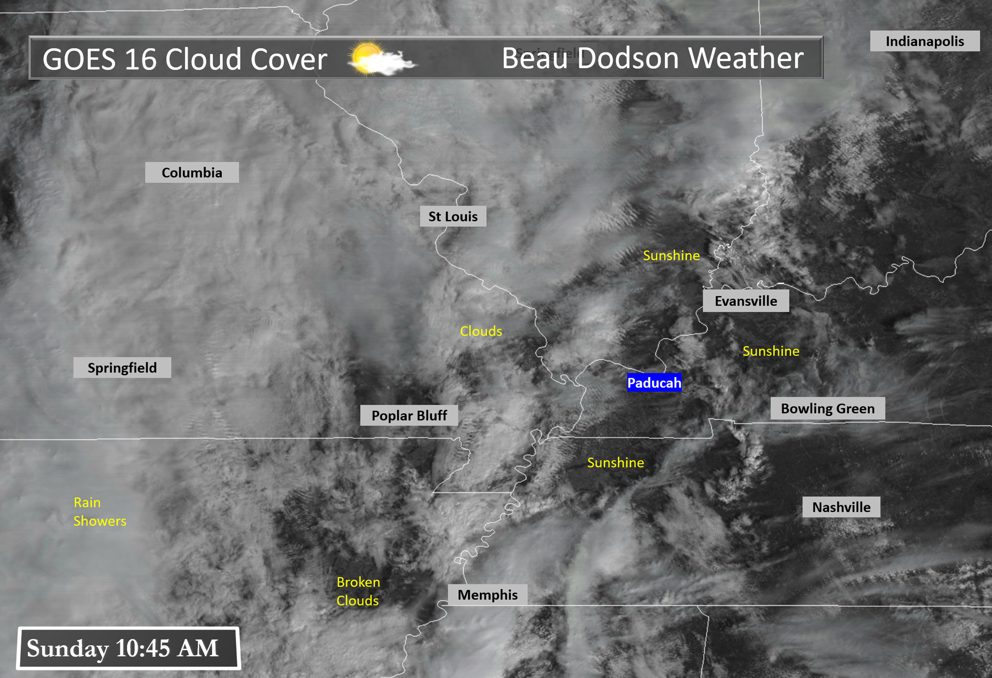
We even had some sun poke through the clouds during the late morning hours. That was not expected. No complaints on sunshine. I know a lot of people had outdoor activities.
Satellite view at 11 AM on Sunday showed the mixture of clouds and sunshine.
Click images to enlarge
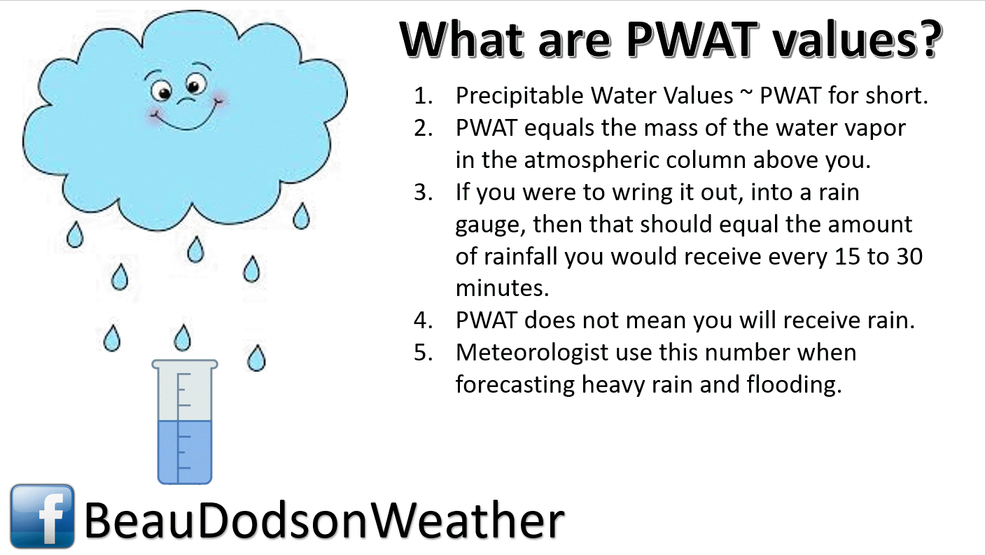
A plume of high PWAT values streamed northward ahead of the cold front.
These numbers are more representative of spring than fall. There was a lot of moisture content in the atmosphere.
Click image to enlarge.
PWAT values of greater than 1.5″ spread across our region. Some areas reached above 1.7″.
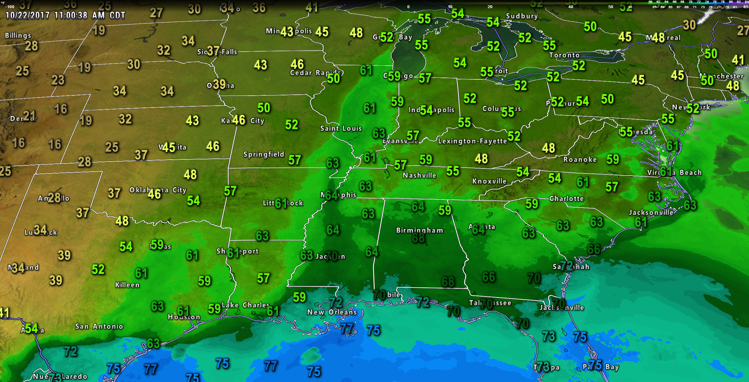
Dew points were also quite high (esp for October).
Dew points reached into the 60’s across the region. A bit humid.
This map was from Sunday late morning.
Notice how the dew points stream out of the Gulf of Mexico into our area.
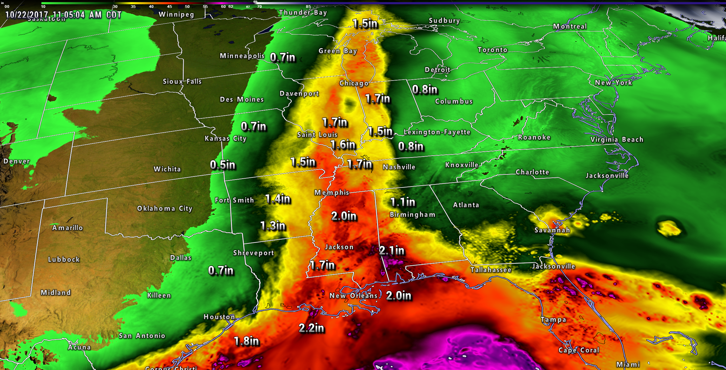
Showers will move along our front into Sunday night and Monday. The greatest concentration of rain will likely be from Tennessee into Kentucky. Southern Illinois, as well.
Some question about how far west the rain band will extend. I do have rain chances in southeast Missouri, as well. Better chances east of the Mississippi River.
Some locally heavy rain will be possible on Sunday night. The greatest chance of that happening would be over our Kentucky counties. The further east you travel the greater the chance of heavier downpours.
Monday will be a mix of sun and clouds for southeast Missouri. Mostly clouds the first half of the day for Illinois and Kentucky. Rain showers will linger into at least Monday morning.
We will have to monitor the timing of the showers leaving Illinois and Kentucky. The system is a slow mover.
Cooler air arrives behind this system on Monday night into Wednesday.
Tuesday will be cool with gusty winds. Temperatures will likely remain in the 50’s. Winds gusting out of the northwest at 10 to 25 mph.
Some clouds on Tuesday. Spotty light showers are also possible.
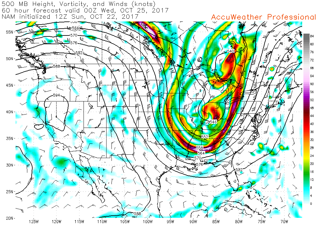
You can see the large upper-level system on these charts.
This is the 500 mb vorticity chart/winds. Notice how the jet stream dives into our region from Canada? The bright colors represent areas where lift is occurring.
You can see the upper level low over the Great Lakes and Indiana. This could mean some clouds on Tuesday and patchy light showers.
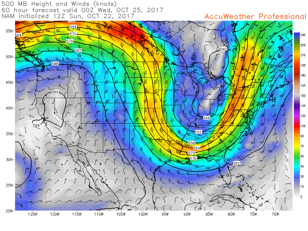
And here is another chart showing the jet stream. Again, notice it diving in from the northwest.
Cold Tuesday night.
If the winds were to subside then light frost would be possible Tuesday night. Not sure winds die down enough for frost. I will monitor trends. Lows will range from 36 to 44 degrees. Some guidance is warmer.
Long range forecast discussion
A stronger cold front will push through the region on Friday/Friday night. This front will be accompanied by a quick moving band of showers. I can’t rule out a thunderstorm, as well.
We should dry out on Saturday and Sunday (assuming the front moves into the area on Friday/Friday night).
Much colder air behind the front. We may be looking at our first widespread frost/freeze next Saturday or Sunday morning. We have several days to monitor the details.
The GFS is quite cold on Saturday morning. It has a cold bias, so I have to be careful about trusting it solely. Either way, it will be colder this coming weekend. Perhaps the coolest air of the season, thus far.
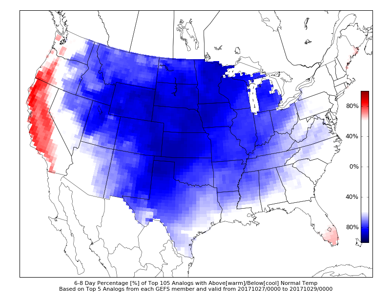
CIPS analogs (models that look at past years and try to compare them to the current atmosphere) show high probabilities for below normal temperatures this coming weekend into the first week of November.
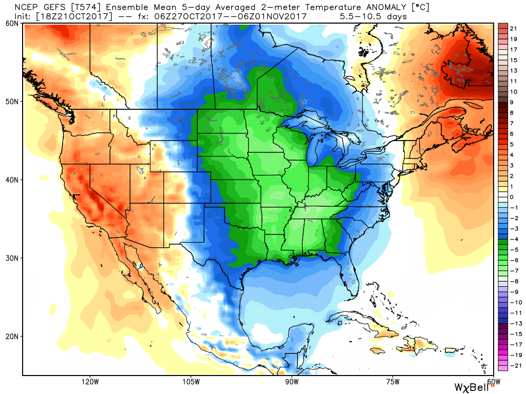
GEFS ensembles. Five-day temperature anomalies for this coming weekend into part of next week. Well below normal temperatures are being forecast by this model.
This is for October 27th through November 1st. When temperatures average below normal. Normal high temperatures are in the middle 60’s and normal low temperatures are in the middle 40’s.
Temperature Forecast
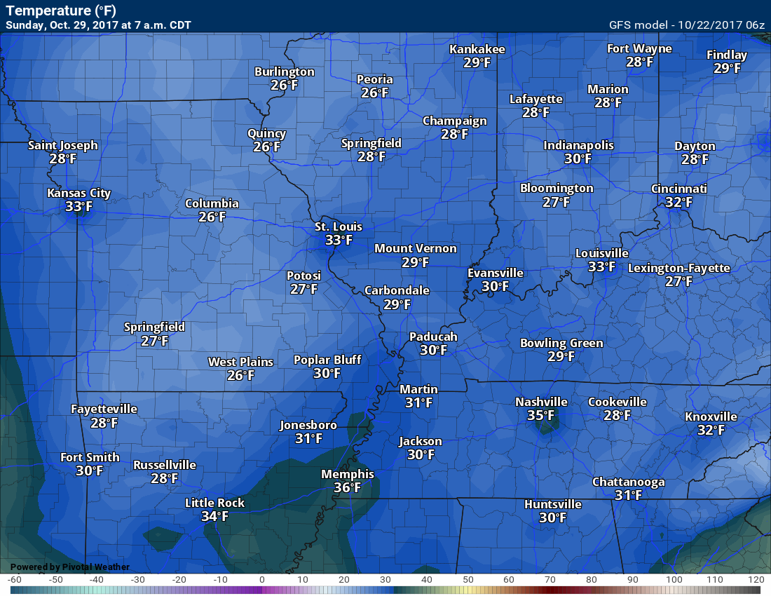
Sunday night lows
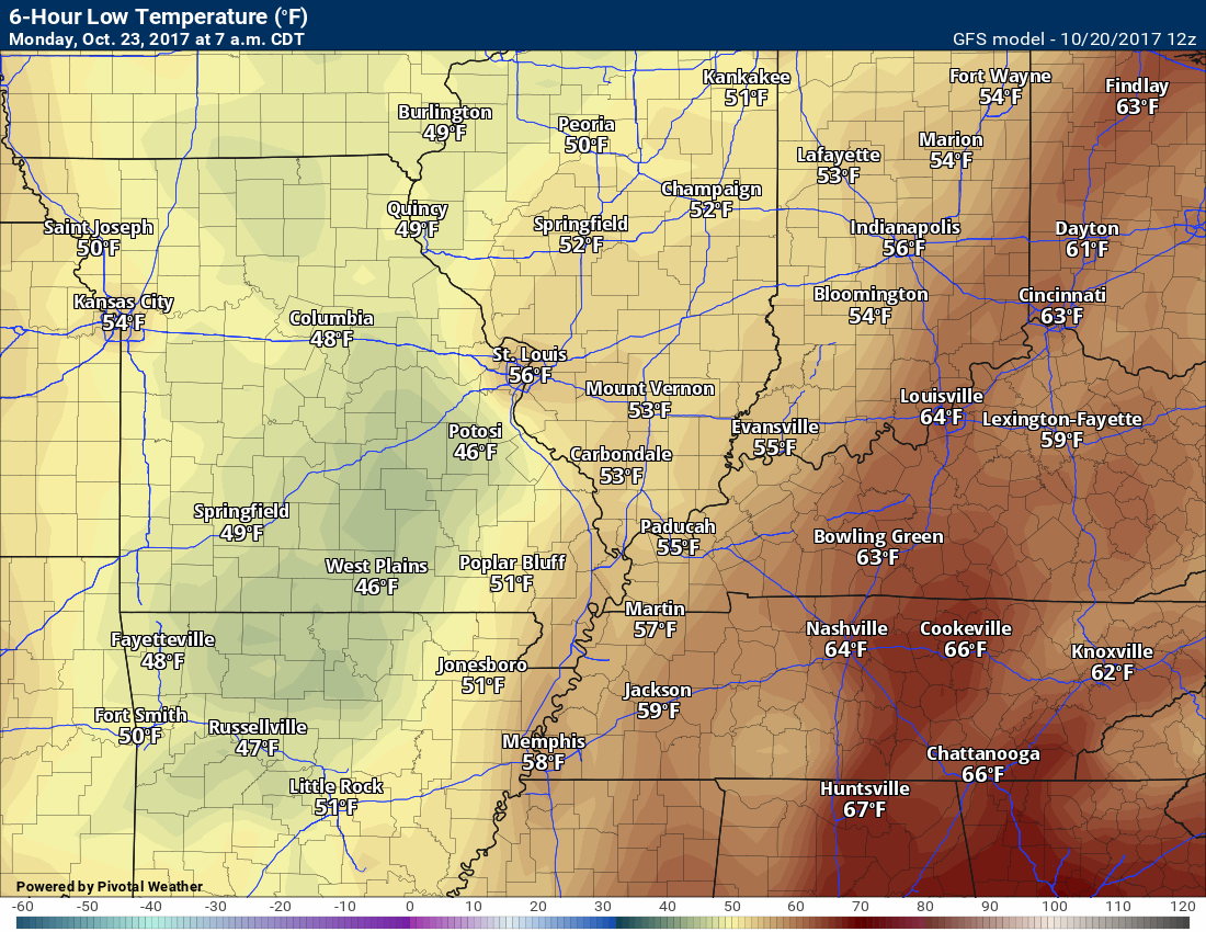
Monday high temperatures
Monday low temperatures
.
Are you subscribing to Weather Talk app/text messages and videos? This is what helps support all of the data you see each day.
We now offer premium videos for the short and long-range forecasts! These videos are produced by a team of long-range forecast experts. They are brought to you as bonus information. Activate text option four in order to receive these on your app or via text.
Subscribe at www.beaudodsonweather.com
We offer an Apple and Android app (scroll to the bottom of this page for more information).

Were you aware that I hired a team of meteorologists for long range videos?
To learn more, click this link
http://cms.weathertalk.com/meet-the-team/
.


We offer regional radars and local city radars – if a radar does not update then try another one. Occasional browsers need their cache cleared. You may also try restarting your browser. This will usually fix any problems.
During the winter you can track snow and ice by clicking the winterize button on the local city view interactive radars.
You may email me at beaudodson@usawx.com
Interactive Weather Radar Page. Choose the city nearest your location: Click this link
National interactive radar: Click this link.
The Beau Dodson Weather APP is ready for Apple and Android users. The app provides a faster way for you to receive my text messages. ATT and Verizon are not always reliable when it comes to speed.
Some of you have asked if you can receive the texts on your phone and the app. The answer to that is, yes. The Android app will automatically allow that to happen. On the Apple app, however, you will need to open your app and click the settings button. Make sure the green tab is OFF. Off means you will still receive the texts to your phone and the app. If you have any questions, then email me at beaudodson@usawx.com
The app is for text subscribers.
The direct download, for the Apple app, can be viewed here
https://itunes.apple.com/us/app/id1190136514
Here is the download link for the Android version Click Here
If you have not signed up for the texting service then you may do so at www.beaudodsonweather.com


——————————————————–
Your support helps with the following:

and

.

Whom do you trust for your weather information?
I have studied weather, in our region, since the late 1970’s. I have 40 years of experience in observing our regions weather patterns. My degree is in Broadcast Meteorology and a Bachelor’s of Science.
My resume includes:
Member of the American Meteorological Society.
NOAA Weather-Ready Nation Ambassador.
Meteorologist for McCracken County Emergency Management. I served from 2005 through 2015.
Meteorologist for McCracken County Rescue. 2015 through current
I own and operate the Southern Illinois Weather Observatory.
I am the chief meteorologist for Weather Talk LLC.
I am also a business owner in western Kentucky.
Recipient of the Mark Trail Award, WPSD Six Who Make A Difference Award, Kentucky Colonel, and the Caesar J. Fiamma” Award from the American Red Cross.
In 2005, I helped open the largest American Cross shelter in U.S. history. This was in Houston, Texas. I was deployed to help with the aftermath of Hurricane Katrina and Hurricane Rita. I was a shelter manager of one of the Houston, Texas shelter divisions.
In 2009 I was presented with the Kentucky Office of Highway Safety Award.
Recognized by the Kentucky House of Representatives for my service to the State of Kentucky leading up to several winter storms and severe weather outbreaks.
If you click on the image below you can read the Kentucky House of Representatives Resolution.

I am President of the Shadow Angel Foundation which serves portions of western Kentucky and southern Illinois.
There is a lot of noise on the internet. A lot of weather maps are posted without explanation. You need a trusted source for information.
My forecast philosophy is simple and straight forward.
- Communicate in simple terms
- To be as accurate as possible within a reasonable time frame before an event
- Interact with you on Twitter, Facebook, email, texts, and this blog
- Minimize the “hype” that you might see through other weather sources
- Push you towards utilizing wall-to-wall LOCAL TV coverage during severe weather events

Sign up for my AWARE email by clicking here.
I typically send AWARE emails before severe weather, winter storms, or other active weather situations. I do not email watches or warnings. The emails are a basic “heads up” concerning incoming weather conditions