We have some great sponsors for the Weather Talk Blog. Please let our sponsors know that you appreciate their support for the Weather Talk Blog.
Milner and Orr Funeral Home and Cremation Services located in Paducah, Kentucky and three other western Kentucky towns – at Milner and Orr they believe in families helping families. You can find Milner and Orr on Facebook, as well.
![]()
.

Are you in need of new eye glasses? New contacts? Perhaps you need an eye exam. Then be sure and visit the Eye Care Associates of western Kentucky (the Paducah location).
For all of your families eye care needs. Visit their web-site here. Or, you can also visit their Facebook page.
.

Best at Enabling Body Shop Profitability since 1996. Located In Paducah Kentucky and Evansville Indiana; serving all customers in between. They provide Customer Service, along with all the tools necessary for body shops to remain educated and competitive. Click the logo above for their main web-site. You can find McClintock Preferred Finishes on Facebook, as well

Expressway Carwash and Express Lube are a locally owned and operated full service Carwash and Lube established in 1987. They have been proudly serving the community for 29 years now at their Park Avenue location and 20 years at their Southside location. They have been lucky enough to partner with Sidecar Deli in 2015, which allows them to provide their customers with not only quality service, but quality food as well. . If you haven’t already, be sure to make Expressway your one stop shop, with their carwash, lube and deli. For hours of operation and pricing visit www.expresswashlube.com or Expressway Carwash on Facebook.

TORNADO SHELTERS! Endrizzi’s Storm Shelters – For more information click here. Endrizzi Contracting and Landscaping can be found on Facebook, as well – click here
I have launched the new weather texting service! I could use your help. Be sure and sign up and fully support all of the weather data you see each day.
This is a monthly subscription service. Supporting this helps support everything else. The cost is $3 a month for one phone, $5 a month for three phones, and $10 a month for seven phones.
For more information visit BeauDodsonWeather.com
Or directly sign up at Weathertalk.com


This forecast update covers far southern Illinois, far southeast Missouri, and far western Kentucky. See the coverage map on the right side of the blog..
New! Video page on the main Weather Talk web-site.
I am posting videos each day on the WeatherTalk website.
The videos can be found under the BeauCast tab. Click here..
October 18, 2016
Tuesday Night – Partly cloudy. A few showers and thunderstorms can’t be ruled out as moisture starts to increase in front of the incoming frontal boundary.
What impact is expected? Perhaps some wet roadways. Low confidence on shower development Tuesday night. Lightning possible.
Temperatures: Lows in the 64-68 degree range
Winds: Southwest winds becoming west at 5-10 mph. Gusts to 15 mph.
What is the chance for precipitation? MO ~ 30%. IL ~ 30%. KY ~ 30% . TN ~ 20%
Coverage of precipitation: Perhaps a couple of showers developing on Tuesday night. A thunderstorm possible.
Is severe weather expected? No
My confidence in this part of the forecast verifying: Medium. Some adjustments in the forecast are possible.
Should I cancel my outdoor plans? No
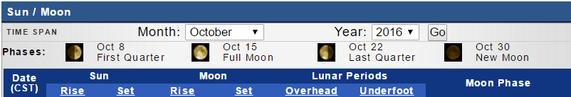
Sunset will be at 6:12 p.m.
Moonrise will be at 8:35 p.m. and moonset will be at 9:48 a.m. Waning Gibbous.
.
Updated at 9 AM Wednesday morning
October 19, 2016
Wednesday: Increasing clouds. Warm. A chance for a few showers and thunderstorms. A frontal boundary will be near our region on Wednesday. There remains some uncertainty on just how fast the front will advance into our forecast counties. A couple of storms could be severe (high winds and hail) over southeast Missouri and southern Illinois during the afternoon hours.
What impact is expected? Wet roadways, lightning, damaging winds, and hail. Tornado risk is low, but not zero.
Temperatures: High temperatures in the 80-85 degree range.
Winds: Southwest winds becoming west/north as the front advances through the area. Winds will become north and northwest behind the front. Winds will be south and south/southeast ahead of the front. Wind speeds of 7-14 mph. Gusty winds along the front and near thunderstorms.
What is the chance for precipitation? MO ~ 40%. IL ~ 40%. KY ~ 20% . TN ~ 20%
Coverage of precipitation? Scattered. Best chance will be over MO/IL. The further north and west you travel the better the chance for storms.
Is severe weather expected? A few storms could produce damaging winds and hail. Tornado risk is small, but not zero.
My confidence in this part of the forecast verifying: Medium. Some adjustments in the forecast are possible.
Should I cancel my outdoor plans? No, but monitor updated forecasts and local radars. Some rain/storms will be possible.
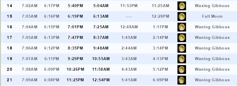
Sunrise will be at 7:07 a.m. and sunset will be at 6:11 p.m.
UV index will be 4-5.
Moonrise will be at 9:29 p.m. and moonset will be at 10:55 a.m. Waning Gibbous.
.
Wednesday Night – Mostly cloudy. A few evening showers/storms possible. Better chances as you head north and west in MO/IL. Increasing chances elsewhere after 2 am. A few storms could be strong. Locally heavy rain over northern parts of southeast MO and northern parts of southern IL.
What impact is expected? Wet roadways and lightning. Locally heavy rain. A few evening storms could be severe with high winds and hail. The intense storms would be confined to southern Missouri into northern parts of southeast Missouri and northern parts of southern Illinois. Lesser risk elsewhere.
Temperatures: Lows in the 56-64 degree range. Cooler behind the cold front. Warmer in front of the front. Temperatures will vary based on the location of the cold front.
Winds: Behind the cold front you can expect north and northeast at 4-8 mph. Gusts to 12 mph. Winds ahead of the front will be from the south and southeast.
What is the chance for precipitation? MO ~60%. IL ~ 60%. KY ~ 60% late . TN ~ 20% before 10 pm. 50% by 5 am.
Coverage of precipitation: Isolated to scattered early. Increasing coverage late tonight into Thursday morning.
Is severe weather expected? A few evening storms could produce damaging winds and hail.
My confidence in this part of the forecast verifying: Medium. Some adjustments in the forecast are possible.
Should I cancel my outdoor plans? I would have a plan B. Rain will be possible on Wednesday night.
.
October 20, 2016
Thursday: Cloudy. Breezy, at times. Showers likely. A rumble of thunder possible. Rain should end from west to east through the day.
What impact is expected? Wet roadways. Small risk for lightning. Gusty winds.
Temperatures: High temperatures in the 64-68 degree range. Falling temperatures possible during the late morning and afternoon.
Winds: North and northeast at 10-20 mph. Gusty at times. Winds during the morning hours could be from the southeast over parts of Kentucky and Tennessee (ahead of the cold front) and they would then switch out of the north behind the front. Gusty winds.
What is the chance for precipitation? MO ~ 60%. IL ~ 60%. KY ~ 60% . TN ~ 60% (decreasing rain chances during the afternoon and evening)
Coverage of precipitation? Perhaps numerous. Precipitation should end from west to east through the day.
Is severe weather expected? No
My confidence in this part of the forecast verifying: Medium. Some adjustments in this forecast are possible.
Should I cancel my outdoor plans? I would monitor updated forecasts. Rain is a possibility.
Sunrise will be at 7:08 a.m. and sunset will be at 6:10 p.m.
UV index will be 0-4.
Moonrise will be at 10:26 p.m. and moonset will be at 11:58 a.m. Waning Gibbous.
.
Thursday Night – Any remaining showers will come to an end. Clearing with just a few clouds. Cooler. Autumn air returns.
What impact is expected? Perhaps a few remaining early evening showers
Temperatures: Lows in the 38-44 degree range.
Winds: North and northwest winds at 4-8 mph. Winds becoming calm after midnight.
What is the chance for precipitation? MO ~ 10%. IL ~ 20%. KY ~ 30% . TN ~ 30%
Coverage of precipitation: Most likely the precipitation will have ended. A few showers possible early in the evening.
Is severe weather expected? No
My confidence in this part of the forecast verifying: High. This forecast should verify.
Should I cancel my outdoor plans? No, but monitor radars
.
October 21, 2016
Friday: Mostly sunny and cooler. Autumn air. A few passing clouds.
What impact is expected? None
Temperatures: High temperatures in the 64-68 degree range.
Winds: North and northwest at 5-10 mph.
What is the chance for precipitation? MO ~ 0%. IL ~ 0%. KY ~ 0% . TN ~ 0%
Coverage of precipitation? None
Is severe weather expected? No
My confidence in this part of the forecast verifying: High. This forecast should verify.
Should I cancel my outdoor plans? No
Sunrise will be at 7:00 a.m. and sunset will be at 6:08 p.m.
UV index will be 4-5
Moonrise will be at 11:25 p.m. and moonset will be at 12:54 p.m. Waning Gibbous.
.
Friday Night – Mostly clear. Cool. Autumn temperatures.
What impact is expected? None
Temperatures: Lows in the 38 to 44 degree range.
Winds: Northwest at 2-4 mph. Winds becoming calm.
What is the chance for precipitation? MO ~0%. IL ~ 0%. KY ~ 0% . TN ~ 0%
Coverage of precipitation: None
Is severe weather expected? No
My confidence in this part of the forecast verifying: High. This forecast should verify.
Should I cancel my outdoor plans? No
.
October 22, 2016
Saturday: Mostly sunny. A few passing clouds. Pleasant Autumn temperatures.
What impact is expected? None
Temperatures: High temperatures in the 65-70 degree range.
Winds: Southwest at 6-12 mph.
What is the chance for precipitation? MO ~ 0%. IL ~ 0%. KY ~ 0% . TN ~ 0%
Coverage of precipitation? None
Is severe weather expected? No
My confidence in this part of the forecast verifying: High. This forecast should verify.
Should I cancel my outdoor plans? No
Sunrise will be at 7:10 a.m. and sunset will be at 6:07 p.m.
UV index will be 5-7
Moonrise will be at –:– p.m. and moonset will be at 1:44 p.m. Last Quarter
.
Saturday Night – Mostly clear. Cool.
What impact is expected? None
Temperatures: Lows in the 42-46 degree range.
Winds: Southwest at 2-4 mph.
What is the chance for precipitation? MO ~0%. IL ~ 0%. KY ~ 0% . TN ~ 0%
Coverage of precipitation: None
Is severe weather expected? No
My confidence in this part of the forecast verifying: Medium. Some adjustments are possible.
Should I cancel my outdoor plans? No
.
October 23, 2016
Sunday: Mostly sunny. A few passing clouds. A little warmer.
What impact is expected? None
Temperatures: High temperatures in the 68-74 degree range.
Winds: Southwest at 5-10 mph. Gusts to 15 mph.
What is the chance for precipitation? MO ~ 0%. IL ~ 0%. KY ~ 0% . TN ~ 0%
Coverage of precipitation? None
Is severe weather expected? No
My confidence in this part of the forecast verifying: Medium. Some adjustments are possible.
Should I cancel my outdoor plans? No
Sunrise will be at 7:11 a.m. and sunset will be at 6:06 p.m.
UV index will be 5-6
Moonrise will be at 12:25 a.m. and moonset will be at 2:28 p.m. Waning Crescent.
.
Sunday Night – Partly cloudy. Cool.
What impact is expected? None
Temperatures: Lows in the 45-50 degree range.
Winds: West at 5-10 mph. Winds may turn out of the north.
What is the chance for precipitation? MO ~0%. IL ~ 0%. KY ~ 0% . TN ~ 0%
Coverage of precipitation: None
Is severe weather expected? No
My confidence in this part of the forecast verifying: Medium. Some adjustments are possible.
Should I cancel my outdoor plans? No
.
October 24, 2016
Monday: Mostly sunny. Warmer.
What impact is expected? None
Temperatures: High temperatures in the 68-74 degree range.
Winds: North and northeast at 5-10 mph.
What is the chance for precipitation? MO ~ 0%. IL ~ 0%. KY ~ 0% . TN ~ 0%
Coverage of precipitation? None
Is severe weather expected? No
My confidence in this part of the forecast verifying: Medium. Some adjustments are possible.
Should I cancel my outdoor plans? No
Sunrise will be at 7:12 a.m. and sunset will be at 6:05 p.m.
UV index will be 5-6
Moonrise will be at 1:23 a.m. and moonset will be at 3:07 p.m. Waning Crescent.
.
Monday Night – Mostly clear. Not as cool.
What impact is expected? None
Temperatures: Lows in the 48-54 degree range.
Winds: North at 5 mph.
What is the chance for precipitation? MO ~0%. IL ~ 0%. KY ~ 0% . TN ~ 0%
Coverage of precipitation: None
Is severe weather expected? No
My confidence in this part of the forecast verifying: Medium. Some adjustments are possible.
Should I cancel my outdoor plans? No
.
October 25, 2016
Tuesday: Mostly sunny. Mild.
What impact is expected? None
Temperatures: High temperatures in the 70-75 degree range.
Winds: East and southeast at 5-10 mph.
What is the chance for precipitation? MO ~ 0%. IL ~ 0%. KY ~ 0% . TN ~ 0%
Coverage of precipitation? None
Is severe weather expected? No
My confidence in this part of the forecast verifying: Medium. Some adjustments are possible.
Should I cancel my outdoor plans? No
Sunrise will be at 7:13 a.m. and sunset will be at 6:03 p.m.
UV index will be 5-7
Moonrise will be at 2:24 a.m. and moonset will be at 3:42 p.m. Waning Crescent.
.
Tuesday Night – Mostly clear.
What impact is expected? None
Temperatures: Lows in the 50-55 degree range.
Winds: South and southeast at 5-10 mph.
What is the chance for precipitation? MO ~0%. IL ~ 0%. KY ~ 0% . TN ~ 0%
Coverage of precipitation: None
Is severe weather expected? No
My confidence in this part of the forecast verifying: Medium. Some adjustments are possible.
Should I cancel my outdoor plans? No
.
More information on the UV index. Click here
.
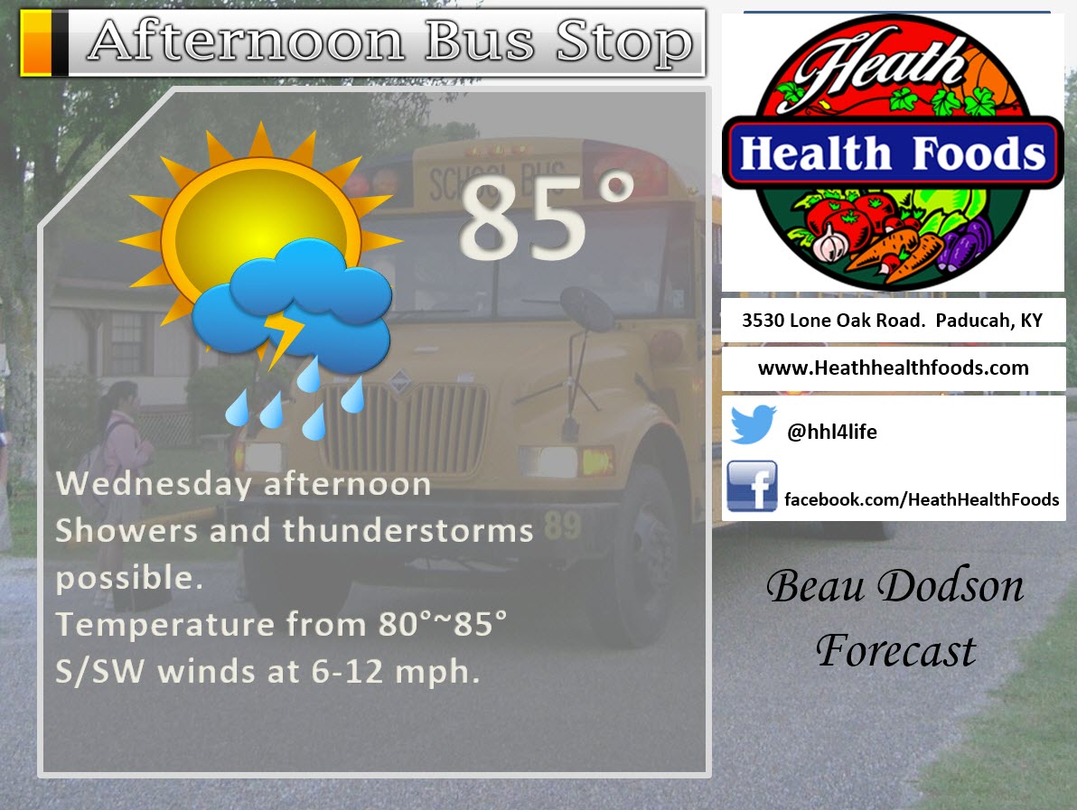
The School Bus Stop Forecast is sponsored by Heath Health and Wellness. Located next to Crowell Pools in Lone Oak, Kentucky.
Visit their web-site here. And. visit Heath Health Foods on Facebook!
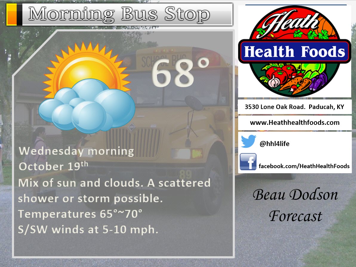

Heath Health Foods is a locally owned and operated retail health and wellness store. Since opening in February 2006; the store has continued to grow as a ministry with an expanding inventory which also offers wellness appointments and services along with educational opportunities. Visit their web-site here. And. visit Heath Health Foods on Facebook!
The weekend forecast is sponsored by Farmer and Company Real Estate. Click here to visit their site.

Farmer & Company Real Estate is proud to represent buyers and sellers in both Southern Illinois and Western Kentucky. With 13 licensed brokers, we can provide years of experience to buyers & sellers of homes, land & farms and commercial & investment properties. We look forward to representing YOU! Follow us on Facebook, as well

Don’t forget to check out the Southern Illinois Weather Observatory web-site for weather maps, tower cams, scanner feeds, radars, and much more! Click here

An explanation of what is happening in the atmosphere over the coming days
- Our October heat comes to an end
- Rain and thunderstorm chances
- Severe weather potential on Wednesday afternoon and evening.
- Much cooler air is on the way
- Nice weekend on tap for the region?
- Storm system next week?
Wow, what a week this has been. Near record or record high temperatures have been the big weather story. Who would have thought we would be talking about upper 80’s in October. Amazing. Could this be one of the top five warmest October’s on record? It is certainly a possibility. We won’t know for a couple of more weeks.
Our warm/hot weather is coming to an end. A strong cold front will push into the region on Wednesday and Wednesday night. This front will increase our rain chances. It has been dry. We could use some rain.
We will have some scattered shower and thunderstorm chances as early as tonight and Wednesday morning. Perhaps the best chance (30% or so) will be over southeast Missouri and southern Illinois. Smaller chances (20%) for Kentucky and Tennessee. What does a 30% chance mean? It means there will likely be some precipitation on radar, but many areas will remain dry.
Rain chances will increase through the day on Wednesday. Coverage will be greatest over southeast Missouri and southern Illinois. Chances will peak (60%-70%) on Wednesday night and Thursday morning.
Severe weather?
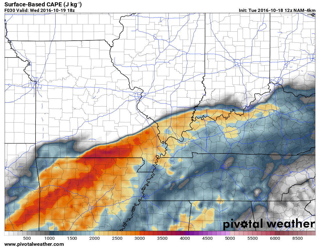
There is enough instability to mention the possibility of strong to severe thunderstorms. This is a change from previous forecasts. Damaging wind gusts would be the main concern. A few reports of hail, as well. The tornado threat appears low, but not zero. We will need to monitor CAPE levels on Wednesday. If instability is more than anticipated then the severe weather forecast would change. As always, monitor updates.
Here are some of the severe weather parameters for Wednesday
This first graphic is for CAPE. CAPE is a measure of instability/energy. The higher the numbers the greater the concern. WRF is bullish on high CAPE numbers. You can figure out where the front is located. SHARP cut-off between CAPE and no CAPE. The yellow, orange, and red colors are where higher CAPE numbers will occur.
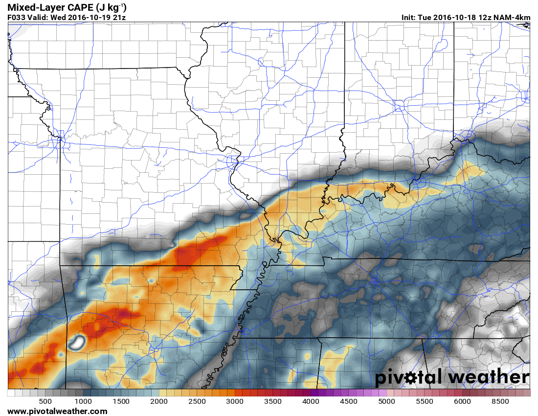
Here is the mixed-layer CAPE. Again, numbers are spiking on Wednesday afternoon and evening.
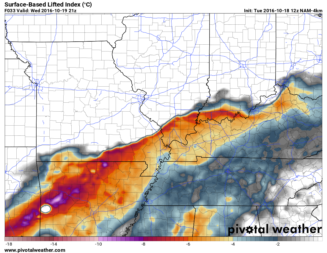
Here is the lifted index (LI). This is another parameter to monitor for severe weather. These are impressive numbers for this time of the year. Another ingredient in the mix.
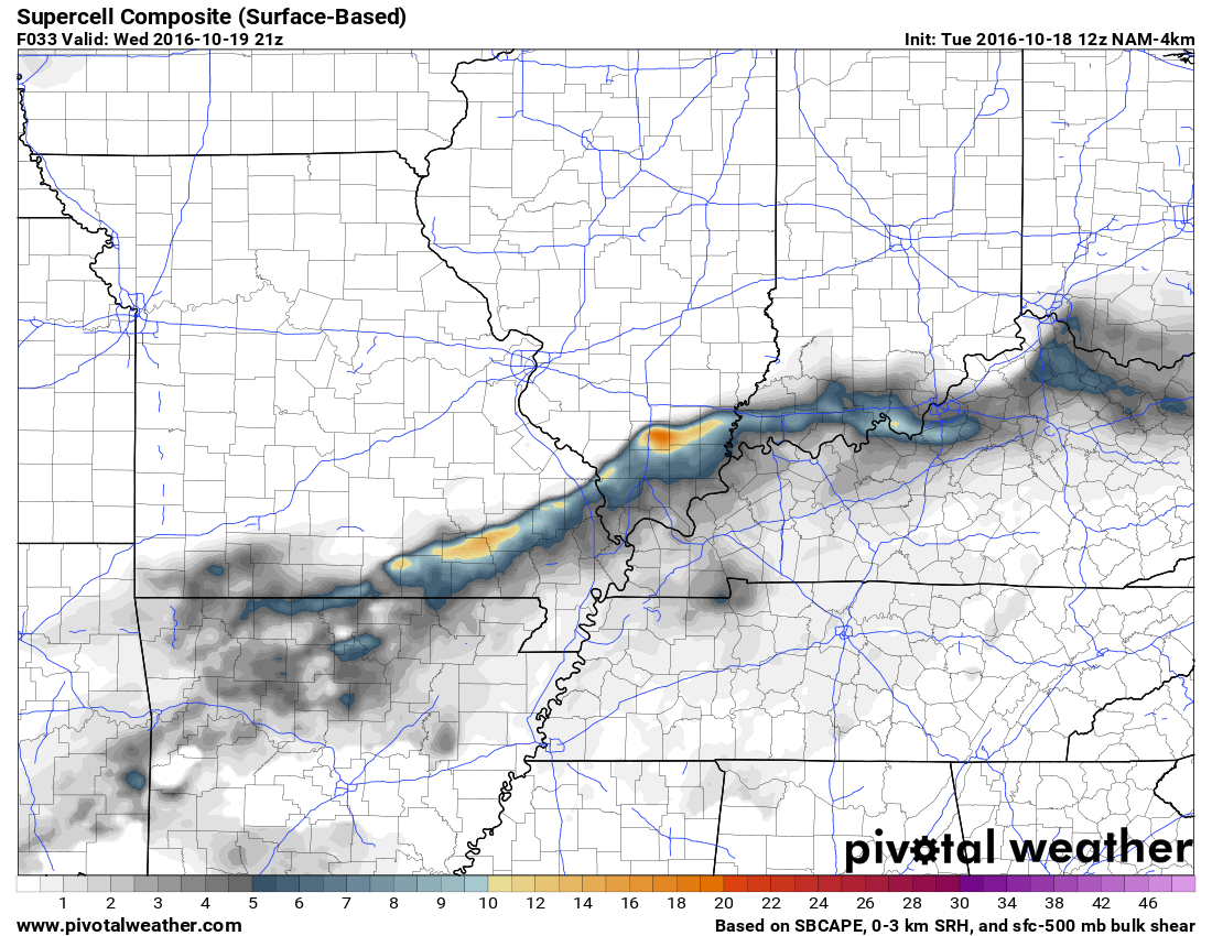
Here is the supercell composite for Wednesday afternoon and Wednesday evening.
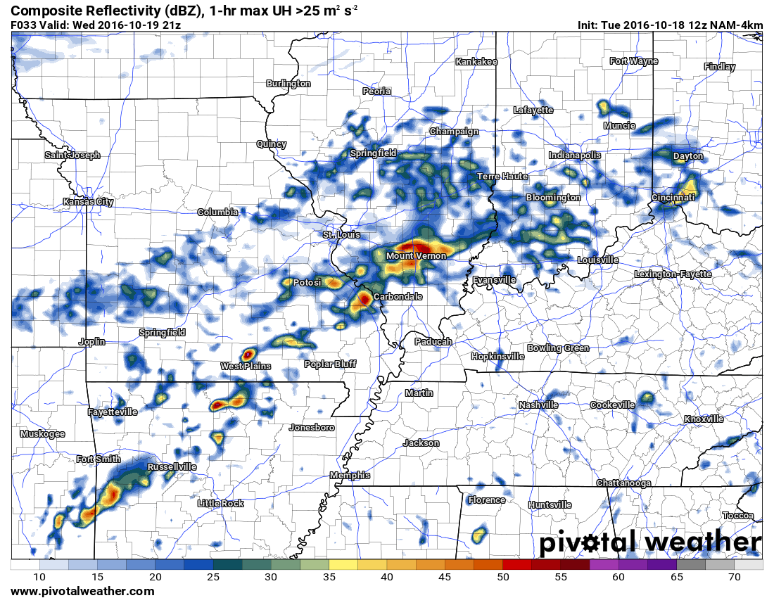
Here is the future-cast radar for Wednesday afternoon and evening. You can see where the WRF model places the thunderstorms. This will need to be monitored.
Rain chances will diminish from west to east on Thursday morning and afternoon. A few showers may remain over the Pennyrile area of western Kentucky on Thursday evening. By Thursday night most of the rain should have come to an end.
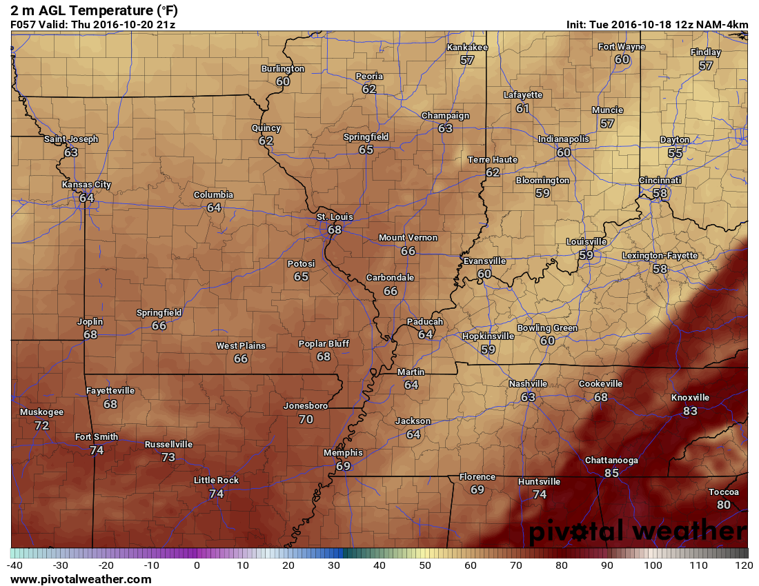
Much cooler air will push into our region behind the cold front. You can expect temperatures in the 60’s on both Thursday and Friday. You can expect overnight lows in the 40’s by Friday morning and Saturday morning. It appears Sunday morning lows will also be in the 40’s. A warming trend will begin on Sunday. We should push back into the 70 to 75 degree range by Sunday and Monday.
I am monitoring another storm system for the middle or end of next week. Thunderstorms? Possibly. Let’s keep an eye on it. Long way off.
Sustained cold air is not showing up in the charts, yet.
Let’s take a look at a few model packages. As you know, there are many different models for meteorologists to look at. The key is figuring out which model is correct. Often times I use a blend of model guidance. Normally there is not one model that is right or wrong. One model might have a handle on rain totals, but not temperatures. A blend approach often times results in a more accurate forecast.
Generally speaking, rainfall totals of 0.25″ to 0.50″ can be expected. The exception will be where training occurs (precipitation repeatedly moving over the same areas). Rainfall totals in these areas could top one inch. Keep that in mind. Totals will vary.
Thunderstorms, as always, can produce locally heavier rain totals.
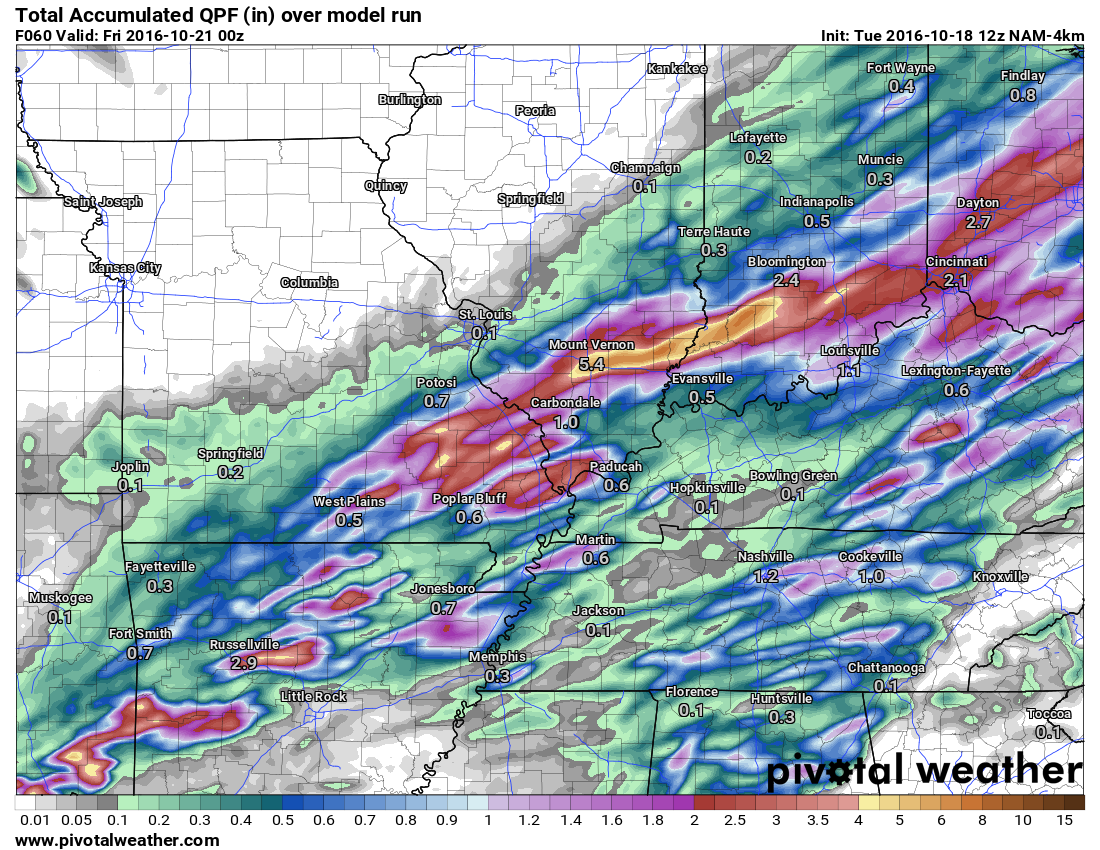
Here is the WRF rainfall totals. It paints some large totals over southern Illinois. This seems a bit much. Yes, some heavier totals will be possible if thunderstorms train over the same areas, but perhaps not quite as much as the WRF model is showing.
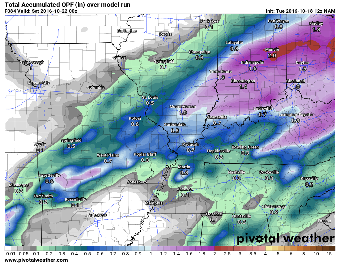
This next image is the lower resolution NAM. You can see some dramatic differences in the totals.
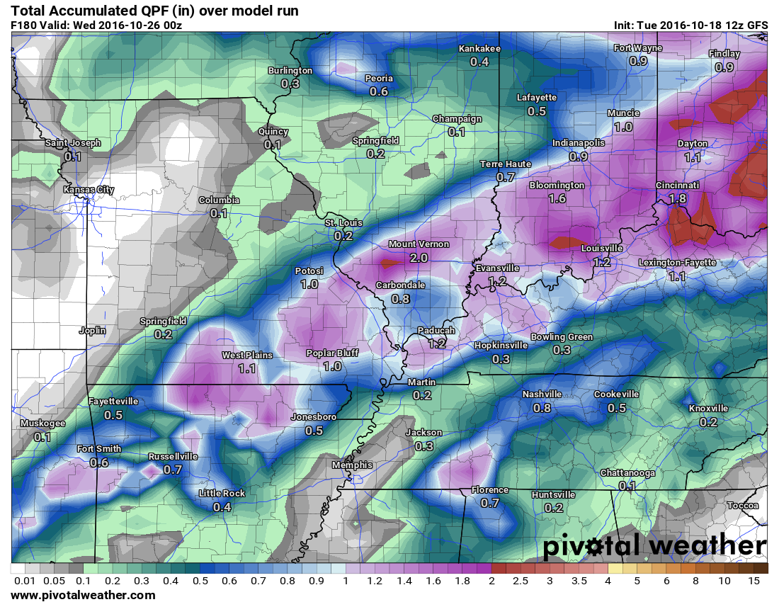
This next graphic is the GFS model guidance. Can you find the running theme? Most of the guidance is painting the heaviest rain totals over Missouri and Illinois. If the front slows/stalls then the heaviest rain totals will occur near that zone. I have the front stalling from south central Missouri into southern Illinois.
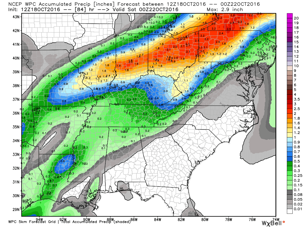
How much rain is NOAA forecasting over the coming days?
.
This is what NOAA is officially forecasting for rain totals. Broad-brushed.
.
Click the image to enlarge.
Keep in mind, these totals will only verify if the front stalls out where WPC has forecasted. If the front stalls further south and east then you can shift the heavier rain totals further south and east.
.
.
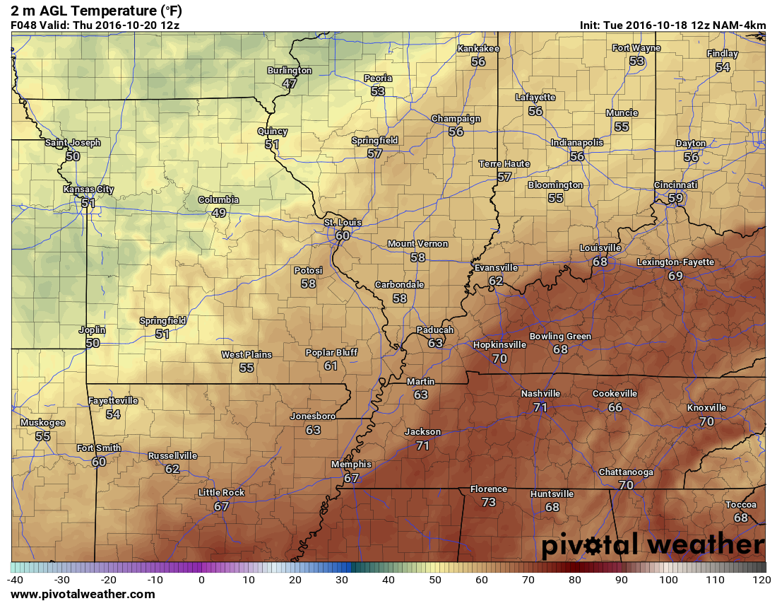
Wednesday morning low temperatures
.

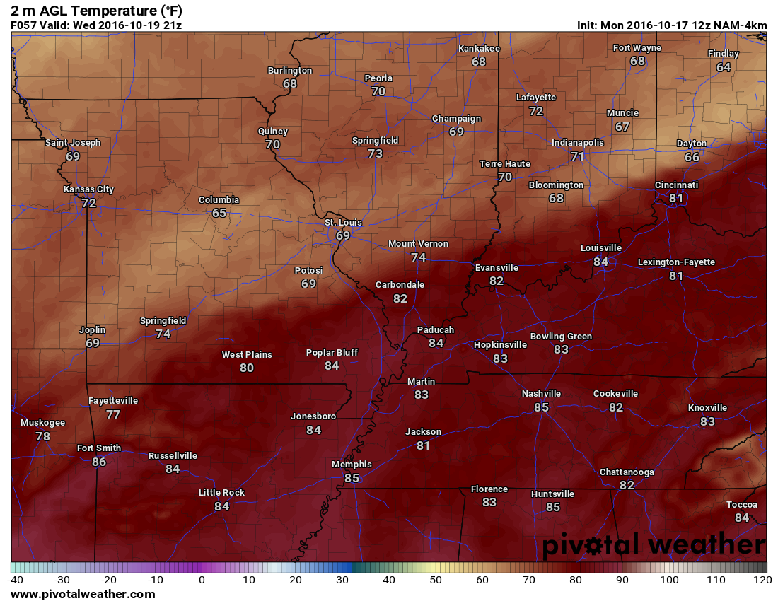
Wednesday afternoon 4 pm temperatures
.
.
.
.
.
.


We have regional radars and local city radars – if a radar does not seem to be updating then try another one. Occasional browsers need their cache cleared. You may also try restarting your browser. That usually fixes the problem. Occasionally we do have a radar go down. That is why I have duplicates. Thus, if one fails then try another one.
If you have any problems then please send me an email beaudodson@usawx.com
WEATHER RADAR PAGE – Click here —
We also have a new national interactive radar – you can view that radar by clicking here.
Local interactive city radars include St Louis, Mt Vernon, Evansville, Poplar Bluff, Cape Girardeau, Marion, Paducah, Hopkinsville, Memphis, Nashville, Dyersburg, and all of eastern Kentucky – these are interactive radars. Local city radars – click here

Live Lightning Data – zoom and pan: Click here
Live Lightning Data with sound (click the sound button on the left side of the page): Click here

Can we expect severe thunderstorms over the next 24 to 48 hours? Remember that a severe thunderstorm is defined as a thunderstorm that produces 58 mph winds or higher, quarter size hail or larger, and/or a tornado.
Tuesday night: Severe weather is not anticipated. I can’t rule out lightning.
Wednesday into Wednesday evening: A few thunderstorms are possible. A few storms could become severe with damaging winds and hail. Tornado risk is low, but not zero.
Thursday: Severe weather is not anticipated. Small risk for lightning.
Friday and Saturday: Severe weather is not anticipated
Sunday and Monday: Severe weather is not anticipated

.
I did update the forecast to include a few stronger storms on Wednesday. Otherwise, no significant changes. I updated the wind direction for Saturday and Sunday. No significant adjustments on temperatures.

.
A few strong storms are possible Wednesday afternoon and evening. The risk for severe weather appears fairly small, but not zero.
.
..

 The latest 8-14 day temperature and precipitation outlook. Note the dates are at the top of the image. These maps DO NOT tell you how high or low temperatures or precipitation will be. They simply give you the probability as to whether temperatures or precipitation will be above or below normal.


Here are the current river stage forecasts. You can click your state and then the dot for your location. It will bring up the full forecast and hydrograph.

Who do you trust for your weather information and who holds them accountable?
I have studied weather in our region since the late 1970’s. I have 37 years of experience in observing our regions weather patterns. I hold a Bachelor’s of Science in Geo-sciences with a concentration in Broadcast Meteorology. I graduated from Mississippi State University.
My resume includes:
Member of the American Meteorological Society.
NOAA Weather-Ready Nation Ambassador.
Meteorologist for McCracken County Emergency Management. I served from 2005 through 2015
Meteorologist for the McCracken County Rescue Squad 2015-current
I own and operate the Southern Illinois Weather Observatory.
Recipient of the Mark Trail Award, WPSD Six Who Make A Difference Award, Kentucky Colonel, and the Caesar J. Fiamma” Award from the American Red Cross.
In 2009 I was presented with the Kentucky Office of Highway Safety Award.
Recognized by the Kentucky House of Representatives for my service to the State of Kentucky leading up to several winter storms and severe weather outbreaks.
I am also President of the Shadow Angel Foundation which serves portions of western Kentucky and southern Illinois.
There is a lot of noise on the internet. A lot of weather maps are posted without explanation. Over time you should learn who to trust for your weather information.
My forecast philosophy is simple and straight forward.
- Communicate in simple terms
- To be as accurate as possible within a reasonable time frame before an event
- Interact with you on Twitter, Facebook, and the blog
- Minimize the “hype” that you might see on television or through other weather sources
- Push you towards utilizing wall-to-wall LOCAL TV coverage during severe weather events
I am a recipient of the Mark Trail Award, WPSD Six Who Make A Difference Award, Kentucky Colonel, and the Caesar J. Fiamma” Award from the American Red Cross. In 2009 I was presented with the Kentucky Office of Highway Safety Award. I was recognized by the Kentucky House of Representatives for my service to the State of Kentucky leading up to several winter storms and severe weather outbreaks.
If you click on the image below you can read the Kentucky House of Representatives Resolution.

Many of my graphics are from www.weatherbell.com – a great resource for weather data, model data, and more


You can sign up for my AWARE email by clicking here I typically send out AWARE emails before severe weather, winter storms, or other active weather situations. I do not email watches or warnings. The emails are a basic “heads up” concerning incoming weather conditions.