We have some great sponsors for the Weather Talk Blog. Please let our sponsors know that you appreciate their support for the Weather Talk Blog.
Milner and Orr Funeral Home and Cremation Services located in Paducah, Kentucky and three other western Kentucky towns – at Milner and Orr they believe in families helping families. You can find Milner and Orr on Facebook, as well.
![]()
.

Are you in need of new eye glasses? New contacts? Perhaps you need an eye exam. Then be sure and visit the Eye Care Associates of western Kentucky (the Paducah location).
For all of your families eye care needs. Visit their web-site here. Or, you can also visit their Facebook page.
.

Best at Enabling Body Shop Profitability since 1996. Located In Paducah Kentucky and Evansville Indiana; serving all customers in between. They provide Customer Service, along with all the tools necessary for body shops to remain educated and competitive. Click the logo above for their main web-site. You can find McClintock Preferred Finishes on Facebook, as well

Expressway Carwash and Express Lube are a locally owned and operated full service Carwash and Lube established in 1987. They have been proudly serving the community for 29 years now at their Park Avenue location and 20 years at their Southside location. They have been lucky enough to partner with Sidecar Deli in 2015, which allows them to provide their customers with not only quality service, but quality food as well. . If you haven’t already, be sure to make Expressway your one stop shop, with their carwash, lube and deli. For hours of operation and pricing visit www.expresswashlube.com or Expressway Carwash on Facebook.

TORNADO SHELTERS! Endrizzi’s Storm Shelters – For more information click here. Endrizzi Contracting and Landscaping can be found on Facebook, as well – click here
I have launched the new weather texting service! I could use your help. Be sure and sign up and fully support all of the weather data you see each day.
This is a monthly subscription service. Supporting this helps support everything else. The cost is $3 a month for one phone, $5 a month for three phones, and $10 a month for seven phones.
For more information visit BeauDodsonWeather.com
Or directly sign up at Weathertalk.com


This forecast update covers far southern Illinois, far southeast Missouri, and far western Kentucky. See the coverage map on the right side of the blog..
New! Video page on the main Weather Talk web-site.
I am posting videos each day on the WeatherTalk website.
The videos can be found under the BeauCast tab. Click here..
.
WEATHER RADAR PAGE – Click here —
.
October 13, 2016
Thursday Night – Patchy fog possible. Partly cloudy early and then increasing clouds late. A chance for a late night shower over southeast Missouri. Cool temperatures.
What impact is expected? Perhaps some wet roadways late at night.
Temperatures: Lows in the 45-52 degree range
Winds: Northeast and east winds at 3-6 mph.
What is the chance for precipitation? MO ~ 30%. IL ~ 10%. KY ~ 20% . TN ~ 20%
Coverage of precipitation: Perhaps isolated.
Is severe weather expected? No
My confidence in this part of the forecast verifying: Medium. Some adjustments are possible.
Should I cancel my outdoor plans? No
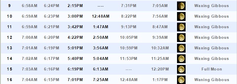
Sunset will be at 6:19 p.m.
Moonrise will be at 5:01 p.m. and moonset will be at 3:56 Waxing Gibbous.
.
October 14, 2016
Friday: Mostly cloudy. A chance for a few scattered showers and perhaps some rumbles of thunder (especially southern counties). There remains some question marks on Friday’s forecast. Best rain chances will be the Missouri Bootheel, western Tennessee, and western Kentucky.
What impact is expected? Wet roadways. Lightning.
Temperatures: High temperatures in the 64-72 degree range. Temperatures will vary based on cloud cover and precipitation.
Winds: East and northeast winds at 5-10 mph.
What is the chance for precipitation? MO ~ 40% (mainly southern). IL ~ 40% (mainly far southern Illinois). KY ~ 50% . TN ~ 60%
Coverage of precipitation? Scattered (best coverage over the southern half of our region)
Is severe weather expected? No
My confidence in this part of the forecast verifying: Medium. Some adjustments are possible.
Should I cancel my outdoor plans? Some rain will be possible. I would not cancel plans, but monitor radars and updated forecasts. Perhaps the best chance of rain will be over far southern Missouri into western Kentucky and Tennessee.
Sunrise will be at 7:02 a.m. and sunset will be at 6:17 p.m.
UV index will be 1-3.
Moonrise will be at 5:40 p.m. and moonset will be at 5:04 Waxing Gibbous.
.
Friday Night – Mostly cloudy. A few lingering showers possible over western Kentucky and western Tennessee. Cool.
What impact is expected? Perhaps some wet roadways. Small risk for lightning.
Temperatures: Lows in the 55-60 degree range
Winds: Southeast winds becoming south winds at 3-6 mph.
What is the chance for precipitation? MO ~ 20%. IL ~ 30%. KY ~ 40% . TN ~ 40%
Coverage of precipitation: Scattered early and then ending from southwest to northeast.
Is severe weather expected? No
My confidence in this part of the forecast verifying: Medium. Some adjustments are possible.
Should I cancel my outdoor plans? No
.
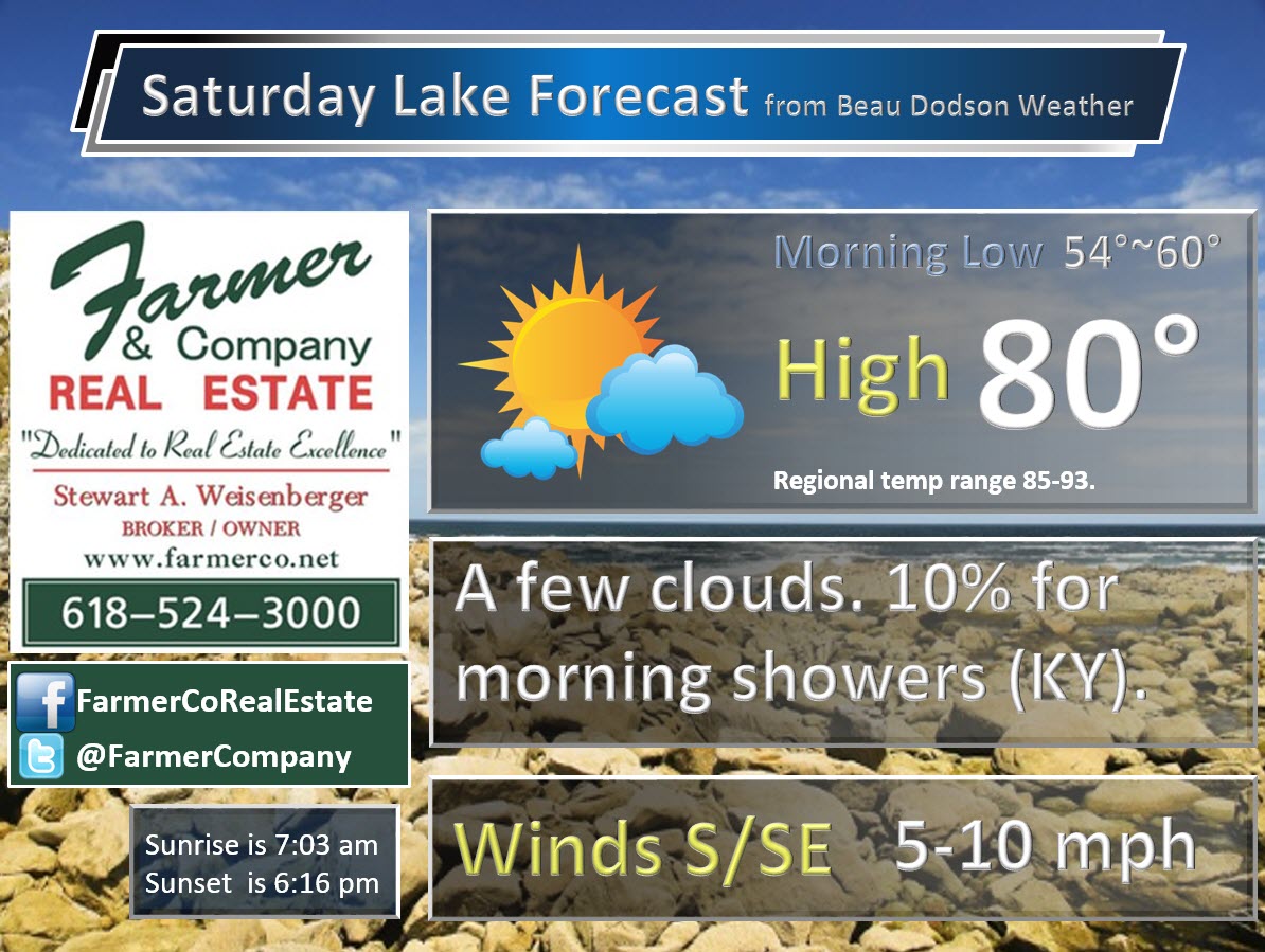
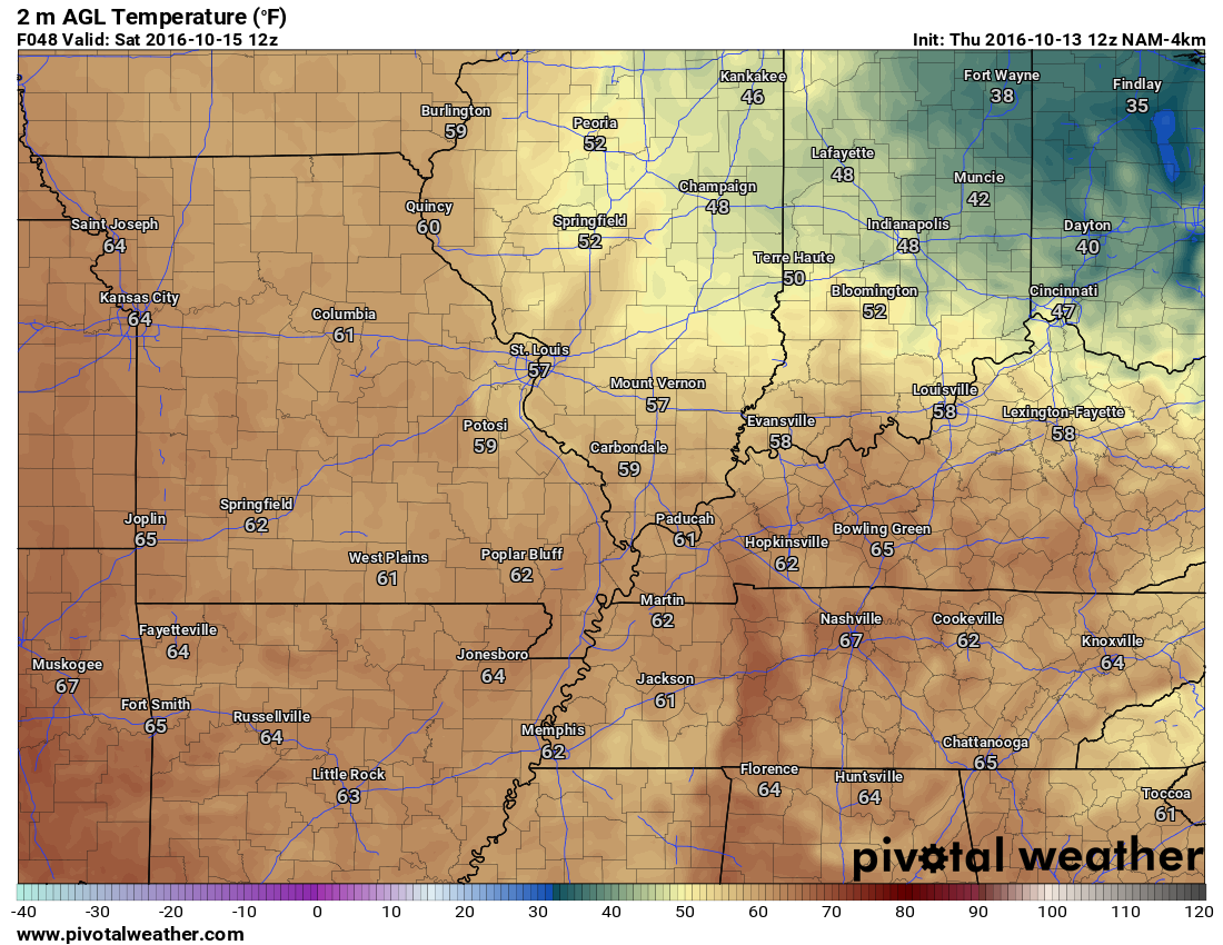
October 15, 2016
Saturday: Partly sunny. Isolated shower chance before 9 am (over western Kentucky). Warmer.
What impact is expected? Most likely none.
Temperatures: High temperatures in the 76-82 degree range.
Winds: South winds at 5-10 mph. Gusts to 15 mph.
What is the chance for precipitation? MO ~ 10%. IL ~ 10%. KY ~ 20% . TN ~ 20%
Coverage of precipitation? None to isolated.
Is severe weather expected? No
My confidence in this part of the forecast verifying: Medium. Some adjustments are possible.
Should I cancel my outdoor plans? No
Sunrise will be at 7:03 a.m. and sunset will be at 6:15 p.m.
UV index will be 6-8. Moderate to high.
Moonrise will be at 6:19 p.m. and moonset will be at 6:13 a.m. Full moon.
.
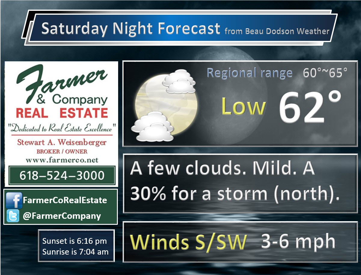
Saturday Night – Patchy fog possible. A few evening clouds. Increasing clouds after midnight over our northern counties in southeast Missouri and southern Illinois. A chance for a shower or thunderstorm after 1 am over the northern parts of southeast Missouri and northern parts of southern Illinois.
What impact is expected? Most likely none. I will be monitoring rain to our north.
Temperatures: Lows in the 60-65 degree range
Winds: South winds at 4-8 mph.
What is the chance for precipitation? MO ~ 20%. IL ~ 20%. KY ~ 10% . TN ~ 10%
Coverage of precipitation: Perhaps isolated
Is severe weather expected? No
My confidence in this part of the forecast verifying: Medium. Some adjustments are possible.
Should I cancel my outdoor plans? No
.
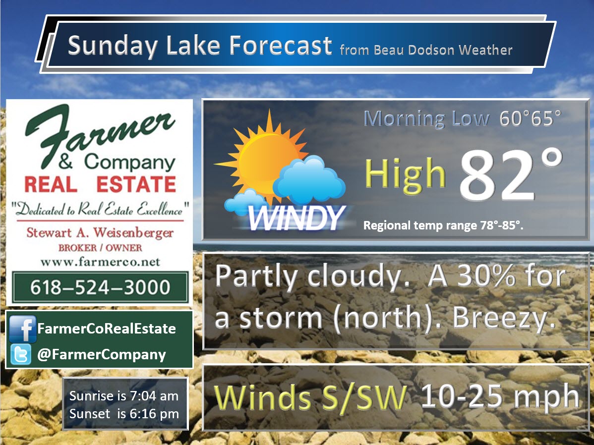
October 16, 2016
Sunday: A mix of sun and clouds. A chance for a few showers and thunderstorms over the northern parts of southeast Missouri and northern parts of southern Illinois. Smaller chances as you move southward in the region.
What impact is expected? Perhaps some wet roadways. Lightning.
Temperatures: High temperatures in the 76-85 degree range. Cooler north and warmer south. Clouds could keep some areas in the middle to upper 70’s. That would probably be from Farmington, MO towards Carmi, IL (northward).
Winds: South winds at 10-20 mph. Gusts well above 20 mph possible.
What is the chance for precipitation? MO ~ 30% IL ~ 40% KY ~ 20% TN ~ 20%
Coverage of precipitation? Scattered (monitor updates)
Is severe weather expected? Not at this time
My confidence in this part of the forecast verifying: Low. Significant adjustments in the forecast are possible.
Should I cancel my outdoor plans? No
Sunrise will be at 7:04 p.m. and sunset will be at 6:15 a.m.
UV index will be 3-6.
Moonrise will be at 7:01 p.m. and moonset will be at 7:25 a.m. Waning Gibbous.
.
Sunday Night – Partly cloudy.
What impact is expected? None
Temperatures: Lows in the 62-66 degree range
Winds: South and southwest winds at 4-8 mph. Gusts to 15 mph.
What is the chance for precipitation? MO ~ 0%. IL ~ 10%. KY ~ 0% . TN ~ 0%
Coverage of precipitation: Most likely none.
Is severe weather expected? No
My confidence in this part of the forecast verifying: Medium. Some adjustments in the forecast are possible.
Should I cancel my outdoor plans? No
.
October 17, 2016
Monday: Partly sunny. Very warm with near record highs.
What impact is expected? None
Temperatures: High temperatures in the 84-88 degree range.
Winds: South and southwest winds at 10-20 mph. Gusty, at times.
What is the chance for precipitation? MO ~ 0%. IL ~ 0%. KY ~ 0% . TN ~ 0%
Coverage of precipitation? None
Is severe weather expected? No
My confidence in this part of the forecast verifying: Medium. Some adjustments in the forecast are possible.
Should I cancel my outdoor plans? No
Sunrise will be at 7:05 p.m. and sunset will be at 6:13 a.m.
UV index will be 6-8.
Moonrise will be at 7:47 p.m. and moonset will be at 8:37 a.m. Waning Gibbous.
.
Monday Night – Mostly clear sky conditions.
What impact is expected? None
Temperatures: Lows in the 62-66 degree range
Winds: South and southwest winds at 6-12 mph.
What is the chance for precipitation? MO ~ 0%. IL ~ 0%. KY ~ 0% . TN ~ 0%
Coverage of precipitation: None
Is severe weather expected? No
My confidence in this part of the forecast verifying: Medium. Some adjustments in the forecast are possible.
Should I cancel my outdoor plans? No
.
October 18, 2016
Tuesday: Partly cloudy. Mild.
What impact is expected? Most likely none
Temperatures: High temperatures in the 84-88 degree range.
Winds: South and southwest winds at 10-20 mph.
What is the chance for precipitation? MO ~ 10%. IL ~ 10%. KY ~ 10% . TN ~ 10%
Coverage of precipitation? Most likely none.
Is severe weather expected? No
My confidence in this part of the forecast verifying: Medium. Some adjustments in the forecast are possible.
Should I cancel my outdoor plans? No
Sunrise will be at 7:06 p.m. and sunset will be at 6:12 a.m.
UV index will be 5-7.
Moonrise will be at 8:35 p.m. and moonset will be at 9:48 a.m. Waning Gibbous.
.
Tuesday Night – Partly cloudy. A shower possible.
What impact is expected? Perhaps wet roadways.
Temperatures: Lows in the 62-66 degree range
Winds: Southwest winds becoming west at 8-16 mph.
What is the chance for precipitation? MO ~ 20%. IL ~ 20%. KY ~ 20% . TN ~ 20%
Coverage of precipitation:
Is severe weather expected? No
My confidence in this part of the forecast verifying: Low. Significant adjustments in the forecast are possible.
Should I cancel my outdoor plans? No
.
October 19, 2016
Wednesday: Partly cloudy.
What impact is expected?
Temperatures: High temperatures in the 70-75 degree range.
Winds: North and northeast at 6-12 mph.
What is the chance for precipitation? MO ~ 10%. IL ~ 10%. KY ~ 10% . TN ~ 10%
Coverage of precipitation?
Is severe weather expected?
My confidence in this part of the forecast verifying: Low. Significant adjustments in the forecast are possible.
Should I cancel my outdoor plans? No
Sunrise will be at 7:07 p.m. and sunset will be at 6:11 a.m.
UV index will be 2-4.
Moonrise will be at 9:29 p.m. and moonset will be at 10:55 a.m. Waning Gibbous.
.
Wednesday Night – Mostly clear.
What impact is expected?
Temperatures: Lows in the 50-55 degree range.
Winds: Northeast at 4-8 mph.
What is the chance for precipitation? MO ~10%. IL ~ 20%. KY ~ 10% . TN ~ 10%
Coverage of precipitation:
Is severe weather expected?
My confidence in this part of the forecast verifying: Low. Significant adjustments in the forecast are possible.
Should I cancel my outdoor plans? No
.
More information on the UV index. Click here
.
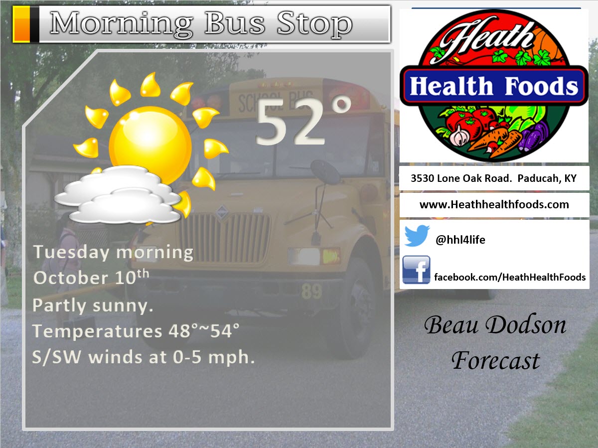
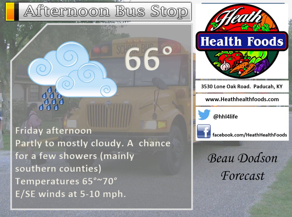
The School Bus Stop Forecast is sponsored by Heath Health and Wellness. Located next to Crowell Pools in Lone Oak, Kentucky.
The best chance for rain on Friday will be over our southern counties. That would include the Missouri Bootheel, western Kentucky, and western Tennessee. The further south you drive the higher the probabilities for some showers.

.
Visit their web-site here. And. visit Heath Health Foods on Facebook!

Heath Health Foods is a locally owned and operated retail health and wellness store. Since opening in February 2006; the store has continued to grow as a ministry with an expanding inventory which also offers wellness appointments and services along with educational opportunities. Visit their web-site here. And. visit Heath Health Foods on Facebook!
.
.
.
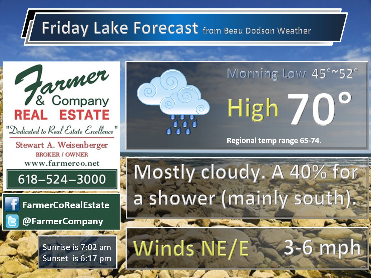
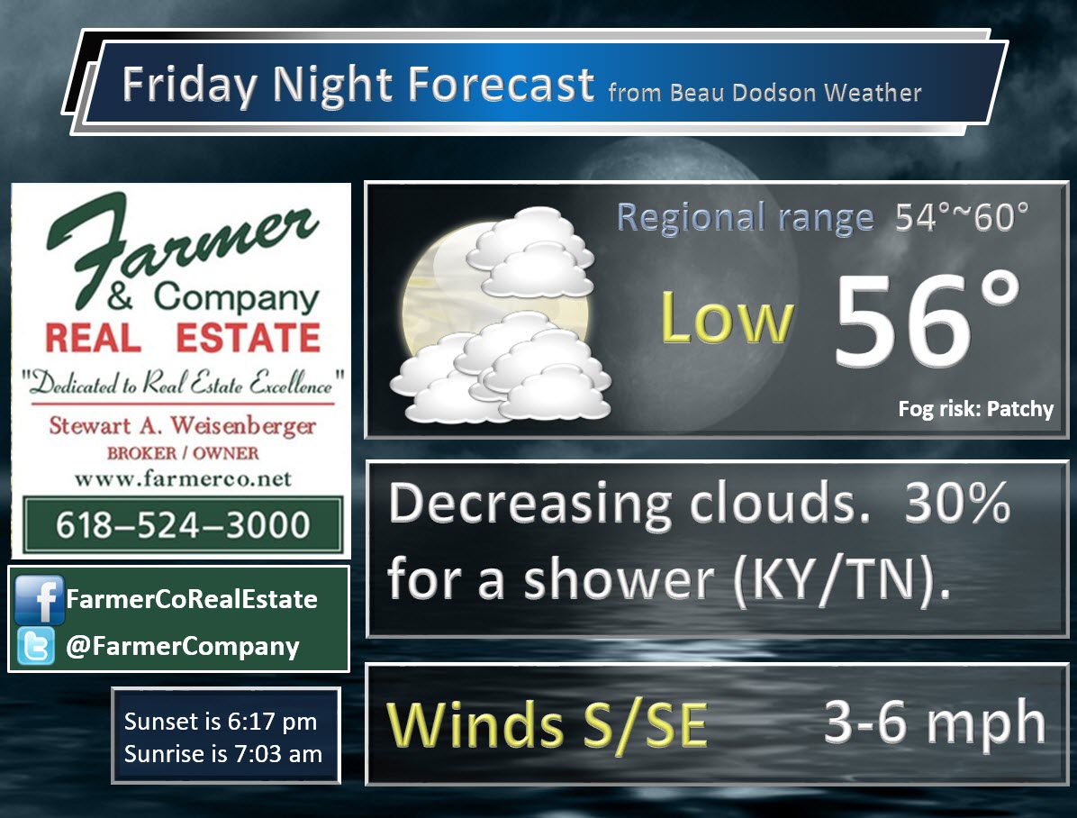
The weekend forecast is sponsored by Farmer and Company Real Estate. Click here to visit their site.

The best chance for rain on Friday will be over our southern counties. That would include the Missouri Bootheel, western Kentucky, and western Tennessee. The further south you drive the higher the probabilities for some showers.
Sunday’s rain chances will mainly be from Farmington, MO towards Mt Vernon, IL. If you were to travel from there northward the rain chances would increase. Smaller chances as you move southward.
Farmer & Company Real Estate is proud to represent buyers and sellers in both Southern Illinois and Western Kentucky. With 13 licensed brokers, we can provide years of experience to buyers & sellers of homes, land & farms and commercial & investment properties. We look forward to representing YOU! Follow us on Facebook, as well

Don’t forget to check out the Southern Illinois Weather Observatory web-site for weather maps, tower cams, scanner feeds, radars, and much more! Click here

An explanation of what is happening in the atmosphere over the coming days
- Two rain chances to monitor into the weekend
- WELL above normal temperatures returning
- A chance for precipitation towards the middle of next week
- Cold snap end of the month?
The main weather story over the coming seven days will be well above normal temperatures.
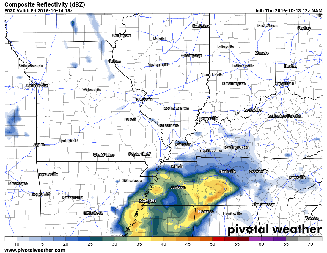
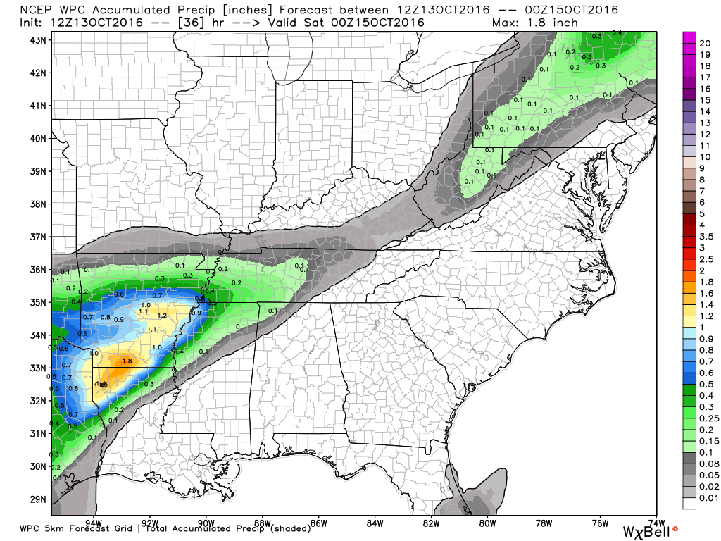
First, let’s take a look at rain chances for Thursday night and Friday.
An upper level disturbance will push into our region late Thursday night and linger into Friday night. This system will have just enough moisture to help produce a few scattered showers and thunderstorms. The best chance for rain will be over southern Missouri, the Missouri Bootheel, western Kentucky, and western Tennessee. Lesser chances as you move northward.
That system will push off to the east by Saturday morning. There is a small chance for a lingering shower on Saturday morning over western Kentucky. Most of Saturday should be dry and mild.
Here is the NAM future-cast radar for late Thursday night into Friday. You can see the bulk of the precipitation is located to our south. There remains some questions as to how far north the precipitation will spread. At least some chance in our region.
Saturday should be mostly dry. A small chance for a shower early Saturday morning over western Kentucky. Warmer on Saturday.
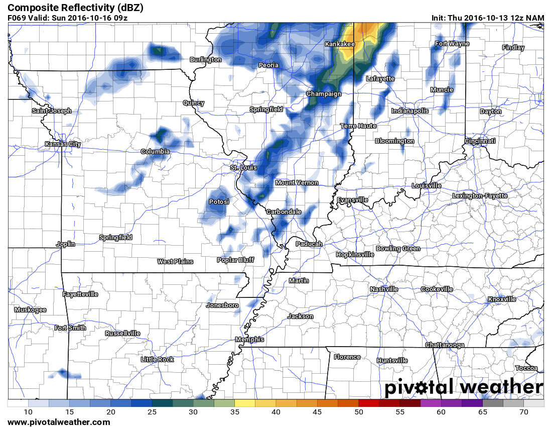
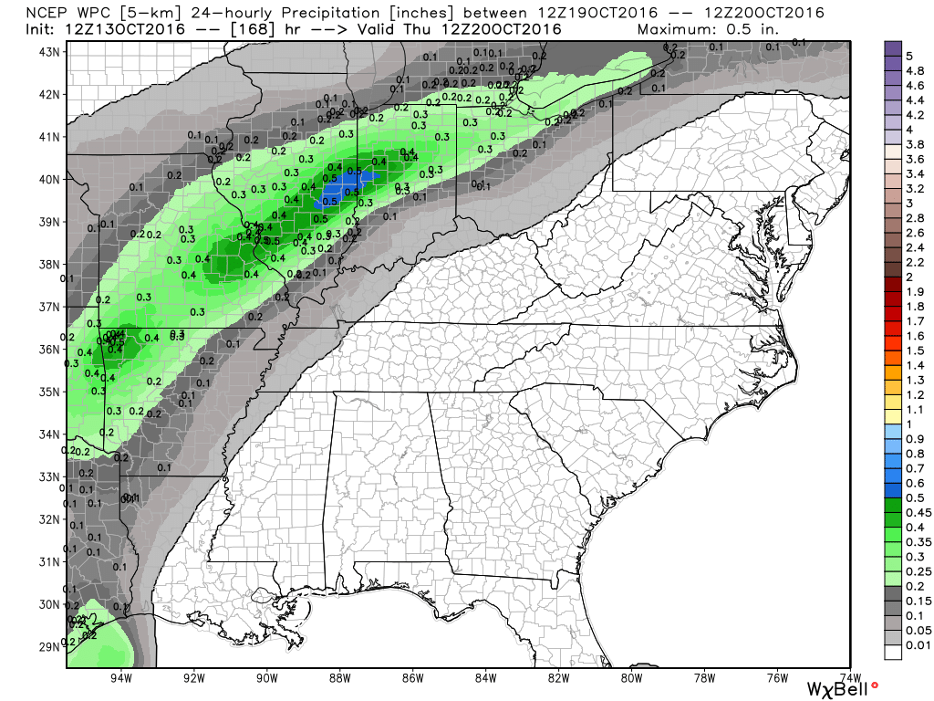
Another system passes to our north late Saturday night into Sunday. This could spark a few showers and storms over our northern counties. The best chances would be from Farmington, Missouri towards Mt Vernon and Carmi, Illinois ~ northward from there. I have capped rain chances at around 40%. Areas further south could have a few isolated showers or storms.
Here is the future-cast radar for Sunday morning at 4 am. Maybe a few showers in our region. Mostly our northern counties.
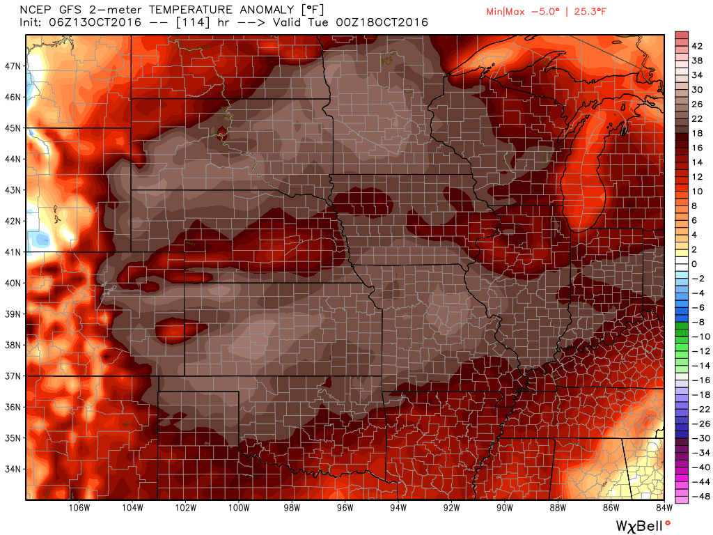
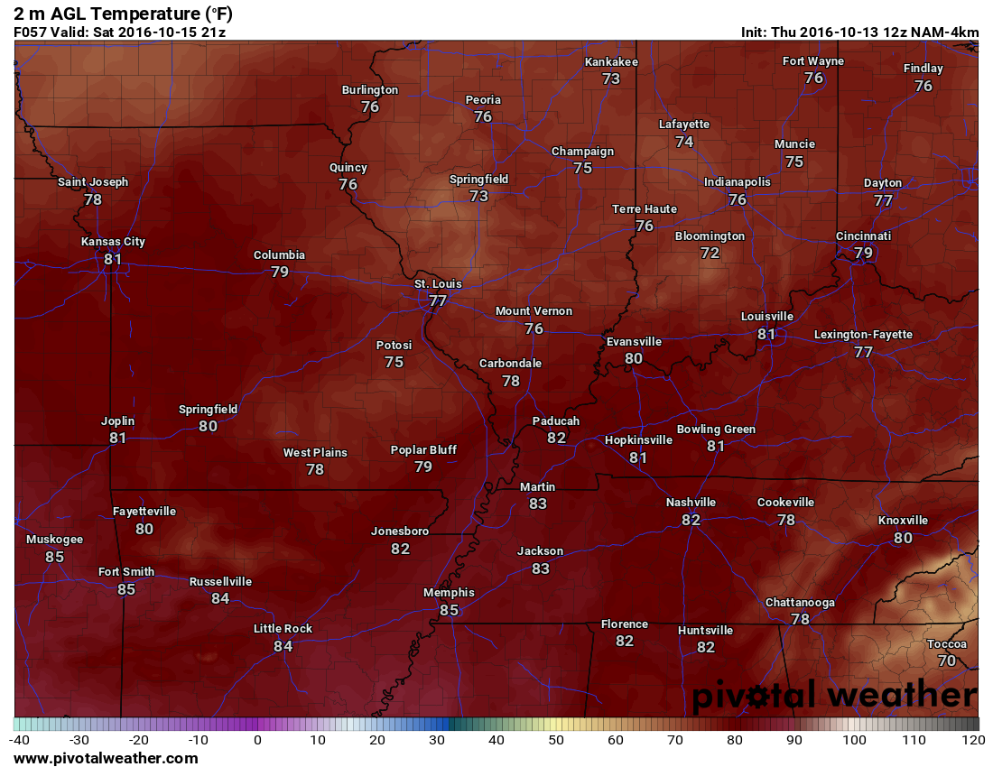
WELL above normal temperatures arrive on Sunday, Monday, Tuesday, and perhaps Wednesday. Highs into the 80’s all four day. Some of the guidance shows upper 80’s on Monday.
Breezy conditions on Sunday. Wind gusts could top 30 mph.
Another cold front is forecast to move into the central United States on Wednesday or Thursday. That front could stall over our region. I am leaning towards at least some chance for thunderstorms on both days. Lower than normal confidence on the Wednesday and Thursday time frame.
Again, the big story will be the warm temperatures. Widespread above normal temperatures for the central United States.
Here is the GFS daily high temperature and low temperature forecast into next week. Check out those 80’s. The day of the week is posted on the bottom of the graph. The temperature can be viewed on the left side of the graphic. Graphic is from weatherbell.com
Normal high temperatures, for this time of the year, are around 72 degrees. Normal low temperatures are around 46 degrees.
Click the image to enlarge

How many degrees above or below normal will temperatures be next week?
Let’s take a look at Monday afternoon. WELL above normal readings.
This next graphic is for Monday night and Tuesday morning. WELL above normal readings.

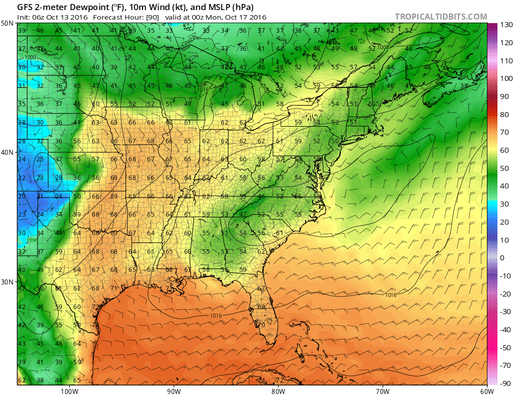
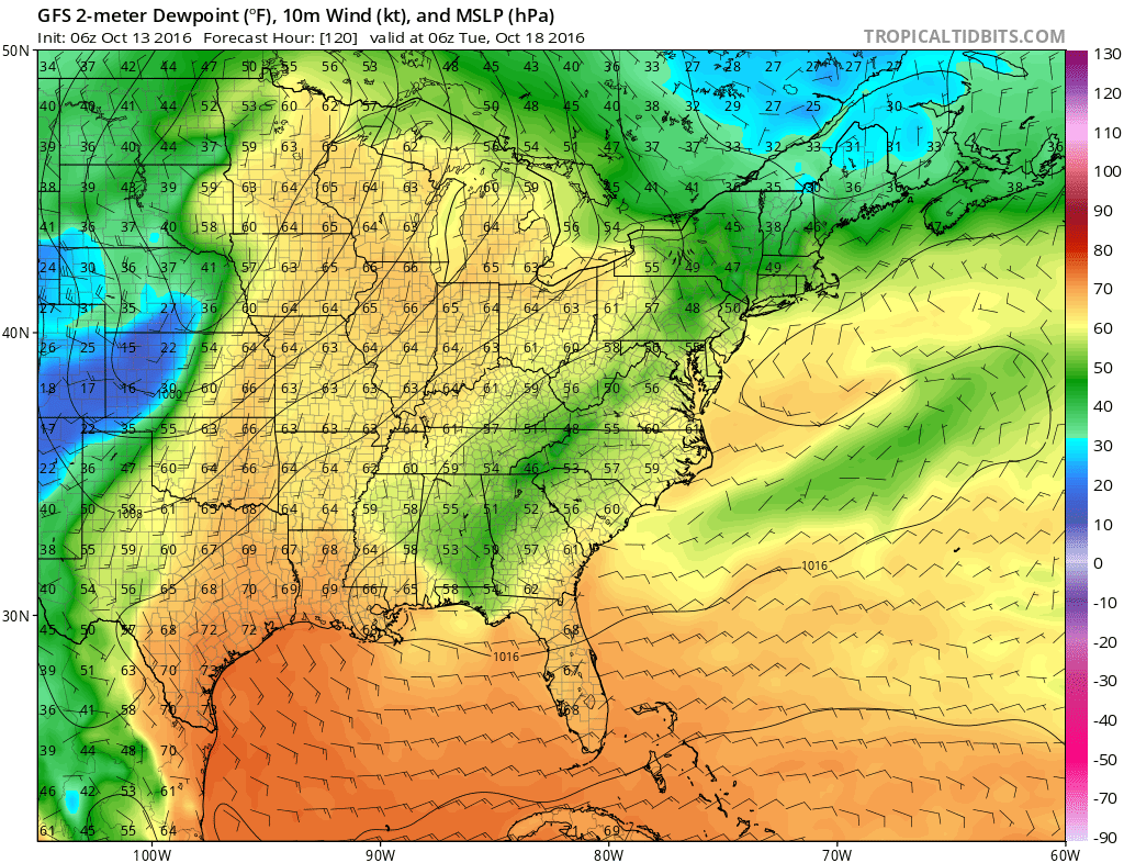
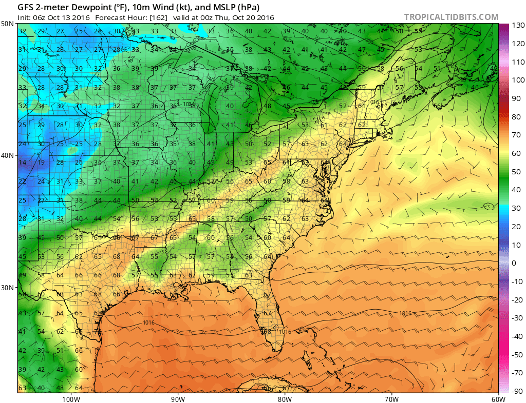
Dew points will be abnormally high this weekend into next week. Let’s take a look at the dew point map. Dew point is a great way to measure moisture at ground level. Dew points into the 60’s would be rather high for this time of the year.
Here is the Sunday dew point map
Here is the Monday night dew point map
Here is the Tuesday night and Wednesday morning dew point map

Can you find the front on the GFS guidance? Sharp drop in dew points behind next weeks frontal boundary.
There are some guidance packages that show frost towards the last week of October. Too far off for certainty. A lot of guidance indicates above normal temperatures may continue into early November. Again, long way off.
Here is the GFS forecast map for Saturday, October 22nd. Check out the deep trough over our region. That would mean below normal temperatures towards the end of next week. A trough is when the jet stream dives southward. Normally that equals unsettled and cooler weather.
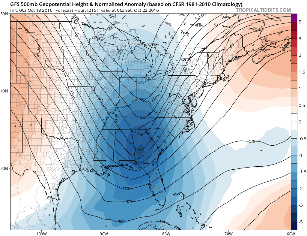
Another trough shows up towards the end of the month. Cooler Halloween? Perhaps.
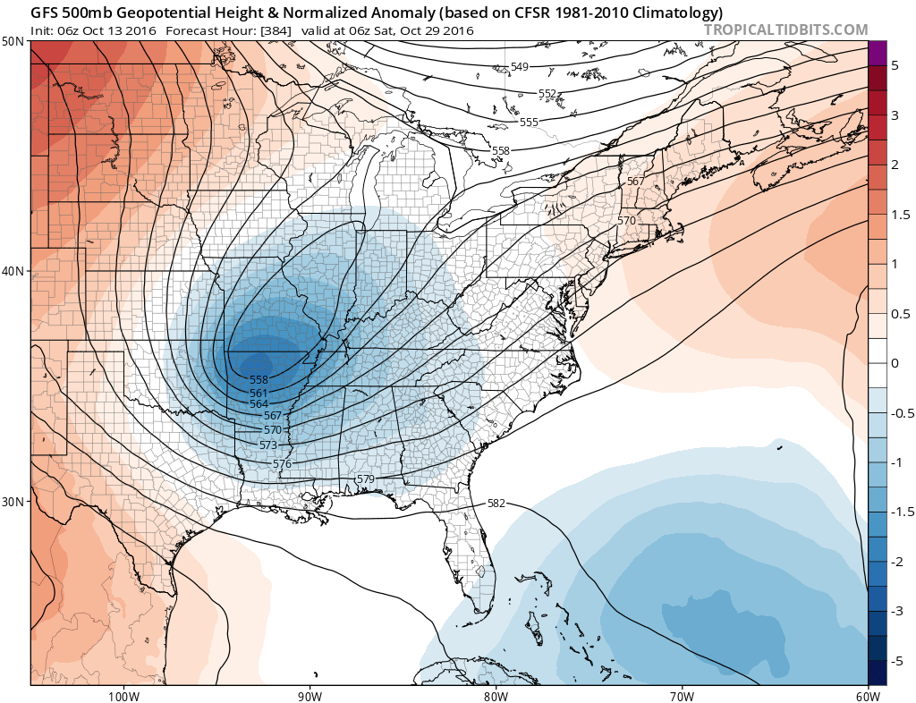
As always, we will have to monitor for severe weather as we move into late October and November. Climatologically speaking, that is the time of year that we normally experience some increase in severe weather. The seasons are changing and the jet stream is headed southward.
How much rain is NOAA forecasting over the coming days?
.
There will be a couple of chances for scattered showers and storms over the next few days. Not everyone will experience measurable rainfall. The first chance arrives late Thursday night into Friday night. The precipitation should mainly be over our southern counties. That would include areas from Poplar Bluff, MO to Carbondale and Marion, IL southward. Areas north of there will have smaller chances for rain. Again, not everyone will experience rain.
The next chance for rain will arrive on Sunday. The rain chances will be over our northern counties. That would include Farmington, MO to Carmi, IL northward. Smaller rain chances south of there.
Here is the official rainfall forecast from NOAA
This is the Friday event. Notice how the measurable rain is confined to our southern counties.
Here is the second rain event for Sunday. This is mainly for our northern counties. Limited amounts.

Finally, this is the third rain event. Perhaps next Wednesday and Thursday (low confidence). I believe the mid-week event should be shifted south and east (from where NOAA has placed it).
.
Friday morning low temperatures
.
.
.
Friday afternoon 4 pm temperatures.
.
.
.
.


We have regional radars and local city radars – if a radar does not seem to be updating then try another one. Occasional browsers need their cache cleared. You may also try restarting your browser. That usually fixes the problem. Occasionally we do have a radar go down. That is why I have duplicates. Thus, if one fails then try another one.
If you have any problems then please send me an email beaudodson@usawx.com
WEATHER RADAR PAGE – Click here —
We also have a new national interactive radar – you can view that radar by clicking here.
Local interactive city radars include St Louis, Mt Vernon, Evansville, Poplar Bluff, Cape Girardeau, Marion, Paducah, Hopkinsville, Memphis, Nashville, Dyersburg, and all of eastern Kentucky – these are interactive radars. Local city radars – click here

Live Lightning Data – zoom and pan: Click here
Live Lightning Data with sound (click the sound button on the left side of the page): Click here

Can we expect severe thunderstorms over the next 24 to 48 hours? Remember that a severe thunderstorm is defined as a thunderstorm that produces 58 mph winds or higher, quarter size hail or larger, and/or a tornado.
Thursday night: Severe weather is not anticipated.
Friday and Friday night: Severe weather is not anticipated.
Saturday and Saturday night: Severe weather is not anticipated.
Sunday: A chance for thunderstorms over our northern counties. Perhaps showers vs storms. Can’t rule out lightning. Most areas will remain dry.
Monday: Severe weather is not anticipated
Tuesday: Severe weather is not anticipated
Wednesday and Thursday: Monitoring for another cold front. Storms are possible, but confidence this far out is low.

.
No major changes
.

.
No major concerns.
.
..

 The latest 8-14 day temperature and precipitation outlook. Note the dates are at the top of the image. These maps DO NOT tell you how high or low temperatures or precipitation will be. They simply give you the probability as to whether temperatures or precipitation will be above or below normal.


Here are the current river stage forecasts. You can click your state and then the dot for your location. It will bring up the full forecast and hydrograph.

Who do you trust for your weather information and who holds them accountable?
I have studied weather in our region since the late 1970’s. I have 37 years of experience in observing our regions weather patterns. I hold a Bachelor’s of Science in Geo-sciences with a concentration in Broadcast Meteorology. I graduated from Mississippi State University.
My resume includes:
Member of the American Meteorological Society.
NOAA Weather-Ready Nation Ambassador.
Meteorologist for McCracken County Emergency Management. I served from 2005 through 2015
Meteorologist for the McCracken County Rescue Squad 2015-current
I own and operate the Southern Illinois Weather Observatory.
Recipient of the Mark Trail Award, WPSD Six Who Make A Difference Award, Kentucky Colonel, and the Caesar J. Fiamma” Award from the American Red Cross.
In 2009 I was presented with the Kentucky Office of Highway Safety Award.
Recognized by the Kentucky House of Representatives for my service to the State of Kentucky leading up to several winter storms and severe weather outbreaks.
I am also President of the Shadow Angel Foundation which serves portions of western Kentucky and southern Illinois.
There is a lot of noise on the internet. A lot of weather maps are posted without explanation. Over time you should learn who to trust for your weather information.
My forecast philosophy is simple and straight forward.
- Communicate in simple terms
- To be as accurate as possible within a reasonable time frame before an event
- Interact with you on Twitter, Facebook, and the blog
- Minimize the “hype” that you might see on television or through other weather sources
- Push you towards utilizing wall-to-wall LOCAL TV coverage during severe weather events
I am a recipient of the Mark Trail Award, WPSD Six Who Make A Difference Award, Kentucky Colonel, and the Caesar J. Fiamma” Award from the American Red Cross. In 2009 I was presented with the Kentucky Office of Highway Safety Award. I was recognized by the Kentucky House of Representatives for my service to the State of Kentucky leading up to several winter storms and severe weather outbreaks.
If you click on the image below you can read the Kentucky House of Representatives Resolution.

Many of my graphics are from www.weatherbell.com – a great resource for weather data, model data, and more


You can sign up for my AWARE email by clicking here I typically send out AWARE emails before severe weather, winter storms, or other active weather situations. I do not email watches or warnings. The emails are a basic “heads up” concerning incoming weather conditions.