We have some great sponsors for the Weather Talk Blog. Please let our sponsors know that you appreciate their support for the Weather Talk Blog.
Milner and Orr Funeral Home and Cremation Services located in Paducah, Kentucky and three other western Kentucky towns – at Milner and Orr they believe in families helping families. You can find Milner and Orr on Facebook, as well.
![]()
.

Wortham Dental Care located in Paducah, Kentucky. The gentle dentist. Mercury free dentistry. They also do safe Mercury removal. You can find Wortham Dental Care on Facebook, as well
.

For all of your families eye care needs. Visit their web-site here. Or, you can also visit their Facebook page.
.

Endrizzi’s Storm Shelters – For more information click here. Endrizzi Contracting and Landscaping can be found on Facebook, as well – click here
.

Best at Enabling Body Shop Profitability since 1996. Located In Paducah Kentucky and Evansville Indiana; serving all customers in between. They provide Customer Service, along with all the tools necessary for body shops to remain educated and competitive. Click the logo above for their main web-site. You can find McClintock Preferred Finishes on Facebook, as well
.

Duck/goose decoys? Game calls? Optics? We have you covered! Click the logo above or visit Final Flight on Facebook, as well.

This forecast update covers far southern Illinois, far southeast Missouri, and far western Kentucky. See the coverage map on the right side of the blog.
Remember that weather evolves. Check back frequently for updates, especially during active weather.
WEATHER RADAR PAGE – Click here —
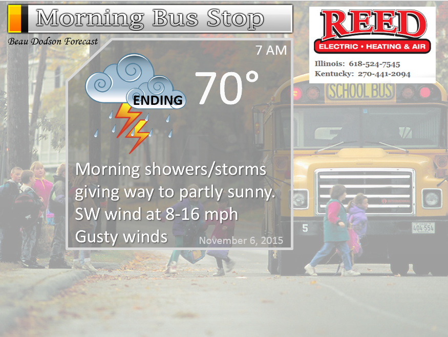
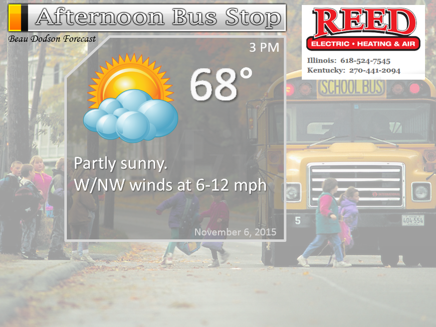
Friday – Showers and thunderstorms between 12 am and 6 am. Then ending from west to east. Becoming partly sunny morning into the afternoon hours.
Temperatures: Highs in the upper 60s to around 70 degrees. Temperatures may fall some in the afternoon.
Winds: Southwest winds becoming northwest after frontal passage. Gusty winds at 10-25 mph early in the day. Diminishing winds in the afternoon.
What is the chance for precipitation? 90% early (before 5 am). Then tapering to 20% in the afternoon.
Coverage of precipitation? Widespread between 12 am and 6 am. Then ending from west to east.
My confidence in this part of the forecast verifying is high
Should I cancel my outdoor plans? There could be some morning thunderstorms giving way to dry conditions by the afternoon hours.
Is severe weather expected? Small severe weather risk during the wee early morning hours of Friday.
What impact is expected? Maybe wet roadways and lightning.
Friday night – Clearing and cooler.
Temperatures: Lows in the lower to middle 40s
Winds: Northwest winds at 5-10 mph
What is the chance for precipitation? 0%
Coverage of precipitation? None
My confidence in this part of the forecast verifying is high
Should I cancel my outdoor plans? No
Is severe weather expected? No
What impact is expected? None
Saturday – Partly sunny and cooler.
Temperatures: Highs in the upper 50s to around 60 degrees.
Winds: North winds at 5-10 mph.
What is the chance for precipitation? 0%
Coverage of precipitation? None
My confidence in this part of the forecast verifying is high
Should I cancel my outdoor plans? No
Is severe weather expected? No
What impact is expected? None
Saturday night – Clearing and colder. Frost possible.
Temperatures: Lows in the middle to upper 30s.
Winds: North winds at 4-8 mph
What is the chance for precipitation? 0%
Coverage of precipitation? None
My confidence in this part of the forecast verifying is high
Should I cancel my outdoor plans? No
Is severe weather expected? No
What impact is expected? Frost possible
Sunday – Partly sunny and cool. Fall.
Temperatures: Highs in the middle 50s
Winds: Northeast winds at 5-10 mph.
What is the chance for precipitation? 0%
Coverage of precipitation? None
My confidence in this part of the forecast verifying is high
Should I cancel my outdoor plans? No
Is severe weather expected? No
What impact is expected? None
Sunday night – Mostly clear and cool. Frost possible. Small chance for a freeze.
Temperatures: Lows in the middle 30s.
Winds: North winds at 0-5 mph
What is the chance for precipitation? 0%
Coverage of precipitation? None
My confidence in this part of the forecast verifying is high
Should I cancel my outdoor plans? No
Is severe weather expected? No
What impact is expected? Frost possible
Monday – Partly sunny and cool. Fall. Some data paints a few showers in the region. Mainly eastern counties. Perhaps parts of western Kentucky.
Temperatures: Highs in the upper 50s to lower 60s
Winds: Northeast winds at 5-10 mph.
What is the chance for precipitation? 20%
Coverage of precipitation? Isolated
My confidence in this part of the forecast verifying is Medium
Should I cancel my outdoor plans? No
Is severe weather expected? No
What impact is expected? None (maybe wet roadways if those showers form)
Monday night – Partly cloudy. Cool.
Temperatures: Lows in the middle 40s.
Winds: Southeast winds at 5 mph.
What is the chance for precipitation? 0%
Coverage of precipitation? None
My confidence in this part of the forecast verifying is medium
Should I cancel my outdoor plans? No
Is severe weather expected? No
What impact is expected? None
Tuesday – Partly sunny.
Temperatures: Highs in the lower 60s
Winds: South winds at 5-10 mph.
What is the chance for precipitation? 0%
Coverage of precipitation? None
My confidence in this part of the forecast verifying is Medium
Should I cancel my outdoor plans? No
Is severe weather expected? No
What impact is expected? None
Tuesday night – Becoming cloudy. A small chance for a shower.
Temperatures: Lows in the upper 40s.
Winds: South winds at 5 mph.
What is the chance for precipitation? 10%
Coverage of precipitation? None
My confidence in this part of the forecast verifying is low to medium
Should I cancel my outdoor plans? No
Is severe weather expected? No
What impact is expected? None
Wednesday – Increasing clouds. A chance for a shower.
Temperatures: Highs in the 64 to 68 degree range.
Winds: South winds at 5-10 mph.
What is the chance for precipitation? 20%
Coverage of precipitation? None. I will be monitoring that next cold front.
My confidence in this part of the forecast verifying is Low
Should I cancel my outdoor plans? No
Is severe weather expected? No
What impact is expected? None
The School Bus Stop Forecast is sponsored by Reed Electric, Heating & Air in Metropolis, IL offers full electrical, heating, and air conditioning services, as well as automatic transfer generators. Our licensed and insured service technicians serve Southern Illinois and Western KY with 24 hour service. Free estimates available for all new installations!
Click their ad below to visit their web-site or click here reedelec.com


![]()


Don’t forget to check out the Southern Illinois Weather Observatory web-site for weather maps, tower cams, scanner feeds, radars, and much more! Click here

An explanation of what is happening in the atmosphere over the coming days…
Highlights
1. Main focus of this update is for Thursday night and Friday morning.
2. We could have some severe weather in the region late tonight into Friday morning. Monitor watches/warnings
3. Biggest concern will be from 12 am until 4 am (give or take) on Friday morning
4. A few reports of damaging wind and/or isolated tornadoes are possible.
5. Cooler for the weekend.
Once again the main focus of this update is the storm system currently moving into the region. A cold front will push through all of our counties late tonight and Friday morning.
A band of showers and thunderstorms has been ongoing from Arkansas into southeast Missouri and southwest Illinois. This band of precipitation has been training over the same area for most of Thursday morning.
Eventually this band of precipitation will shift eastward into the rest of the area.
This first band of precipitation will not produce any severe weather.
A second band of showers and thunderstorms will develop late tonight across parts of Missouri and Arkansas. This will push into southeast Missouri between 10 pm and 12 am. It will then spread eastward from there.
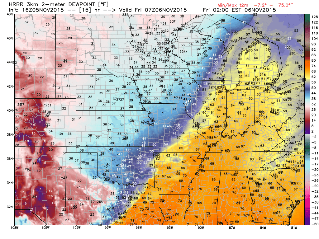
The wind fields aloft will increase considerably tonight. Dew points will also be on the rise. This combination will help CAPE values (energy) rise into the 300 to 600 range. That is plenty sufficient for some concerns.
The turning of the winds with height should be enough to produce the possibility of some reports of damaging winds and even isolated tornadoes. Remember, it only takes one event to cause problems. Remember, when it comes to severe weather that potential does not always make reality.
Look at these amazing dew points for November. If the dew point reaches 60 in November that is usually a red flag. We are looking at the middle to upper 60s on this chart for late tonight and early Friday morning. That is a LOT of moisture in the atmosphere. There are even some 70 dew points on that map. Truly amazing numbers.
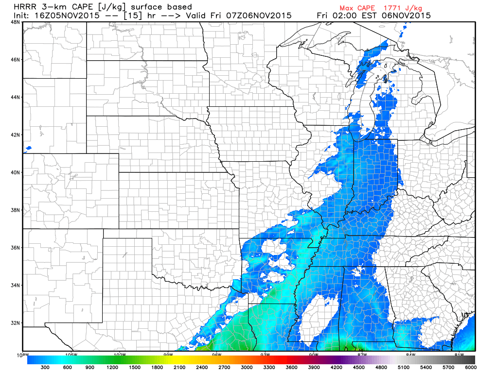
Here is the CAPE map for late tonight and early Friday morning. Not a lot, but enough to cause some concern.
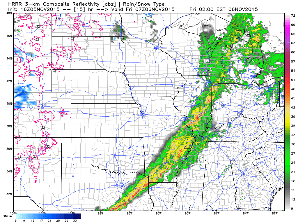
Here is the future-cast radar for late tonight/early Friday morning. A large band of showers and thunderstorms.
Keep in mind that there might not be much lightning with this event.
This radar grab is from weatherbell.com and is for the 2 am hour.
I will be watching the line segments embedded within the precipitation shield. Little lines of thunderstorms. These often times are where severe weather will occur in a setup like this.
If a tornado warning is issued then seek shelter. Keep your NOAA Weather Radios on. I will be up all night for this event. I will be running the next texting service. If severe weather threatens then I will be sending out messages.
Showers and thunderstorms will be moving at 40-60 mph. Fast movers. That means that if warnings are issued there might be little time to take action.
Confidence remains low that we will actually receive some reports of severe weather. Confidence is high that showers and thunderstorms will occur. Tricky forecast and potential does not always make reality when it comes to severe weather. Keep that in mind. I think most of you know this already.
We will dry out by Friday late morning into the afternoon hours. I currently do not have any precipitation in the forecast through Monday morning. There was some data sets that showed a few showers on Monday afternoon and evening. I will dig a bit deeper into this tomorrow.
Colder air arrives behind our cold front. Frost is possible on Sunday morning and Monday morning. Lows will dip into the chilly 30s. A far cry from our current 70s! You knew this wouldn’t last. Fall is here.
WEATHER RADAR PAGE – Click here —
WATCH AND WARNING MAP

REGIONAL RADAR

Historically an event like this is not a straight forward forecast. Often times forecasters can tell you that there are enough ingredients to cause concern. That is the case this time around. There are, however, uncertainties.
Some things are beyond a forecasters capability. For example, no forecaster in our region can guarantee you that there will be some damaging winds and/or a tornado on Thursday night. The best we can do, with the current technology and skill sets, is tell you when ingredients favor an event occurring. And, sometimes severe weather occurs, but is never verified. So, we don’t even know that it occurred. Ahhh the life of a forecaster.
My best advice is to monitor updates on Thursday and Thursday evening. If you have a NOAA Weather Radio then check the batteries and keep it on Thursday night into Friday morning. The timing of the event could occur while most are sleeping.
I have the new texting service. I plan on being up through this event. This is a subscription service. I am doing a soft launch of the service. Be sure and pick the county that is most important to you. Two counties if you work in one and live in another. The messages are county based. The more counties you pick then the more messages you will receive. You don’t want to be flooded with messages for other counties.
Here are the instructions to sign up
Thank you for asking about the new texting service. I am excited about the project.
This is the link where you register for the texting service https://weathertalk.com/?module=register
And here is a short video (if you need assistance)
https://www.youtube.com/watch?v=GzHFC2O4f_s&feature=youtu.be
If you sign up for text messages (the daily forecast option) then you should start receiving those once or twice a day. Depending on the weather. If there are significant changes in the forecast then I will send out an updated text message. Obviously, the severe weather messages will be more frequent when an event is unfolding.
Some phones only allow 130 characters per text. We are working to resolve that issue, as well.
I appreciate your time and help with this new service. I am going to roll it out to everyone in a few weeks. If you know someone that is interested then you may let them know. You can send them this email, as well.
Also, remember that this service helps support all of the weather data that you see on a daily basis. The graphics, Twitter feed, Facebook page, the WeatherTalk blog, the interactive city view radars, and my time.

I also set up a storm tracking page with additional links (use during active weather for quick reference)
Storm Tracking Tool Page
Don’t forget we have interactive city view radars
WEATHER RADAR PAGE – Click here —

No major changes in the forecast.

The main concern will be Thursday night and Friday morning. I can’t rule out a few reports of damaging winds and isolated tornadoes. There is lower than normal confidence on this forecast. Some of the parameters for severe weather are quite impressive, while others are not. Whether the two balance out and produce some severe storms will be the concern.
Monitor warnings.

Yes. Monitor updates concerning the potential for some severe thunderstorms Thursday night and Friday morning. Keep the weather radios on tonight. If warnings are issued then seek shelter immediately. Storms will be moving at speeds of 40-60 mph.

The wild card in the forecast will be whether or not we actually receive some reports of severe weather late tonight and early Friday morning.
The second wild card will be frost on Sunday and Monday morning. Temperatures will drop considerably behind the cold front.

Chance on Sunday, November 8th and the morning of Monday the 9th.

How much precipitation should we expect over the next few days?
Showers and thunderstorms will occur Thursday night into Friday morning. Some locally heavy rain possible.
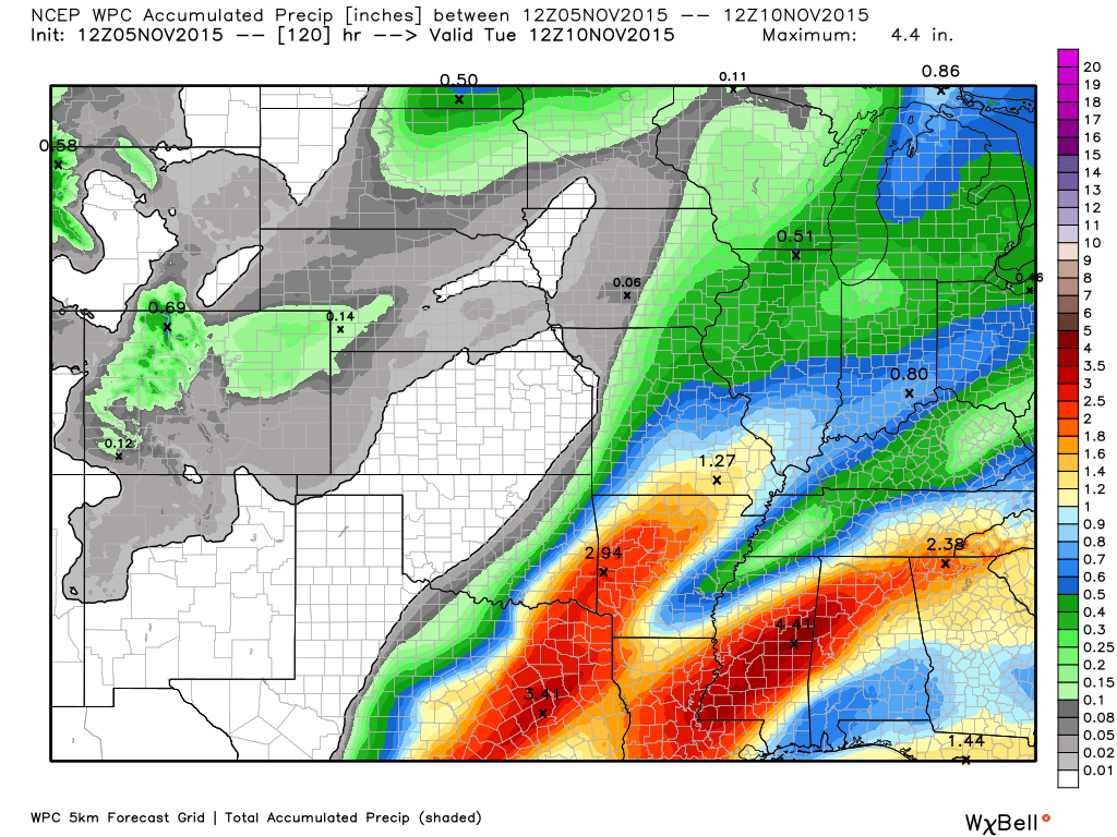
Officially here is the broad brushed rainfall outlook. As always, these amounts could vary considerably.

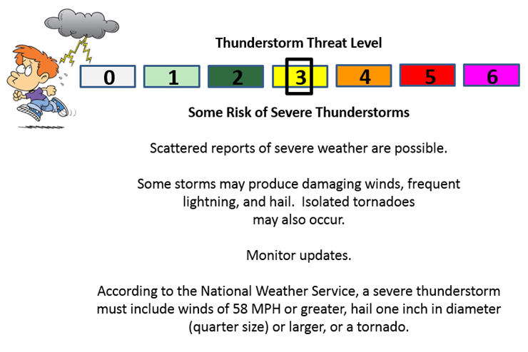
Can we expect severe thunderstorms over the next 24 to 48 hours? Remember that a severe thunderstorm is defined as a thunderstorm that produces 58 mph winds or higher, quarter size hail or larger, and/or a tornado.
Thunderstorm threat level will be a THREE for Thursday night into early Friday morning. Then a ZERO from Friday afternoon through Monday morning.
.
Thursday night: Severe weather is possible on Thursday night and Friday morning. Damaging winds and even tornadoes could occur.
Friday: Monitor updates for early wee hours of Friday morning. Severe weather will be possible. Damaging winds and isolated tornadoes could occur.
Saturday: Severe weather is not anticipated
Sunday: Severe weather is not anticipated.
Monday: Severe weather is not anticipated.
Thursday night and Friday morning (before 9 am on Friday) A level three. Hail is unlikely. Isolated damaging wind risk. Isolated tornado risk. Overall, the risk at any given location appears small, but not zero. There might not be much lightning with this event.
I also set up a storm tracking page with additional links (use during active weather for quick reference)
Storm Tracking Tool Page

We have regional radars and local city radars – if a radar does not seem to be updating then try another one. Occasional browsers need their cache cleared. You may also try restarting your browser. That usually fixes the problem. Occasionally we do have a radar go down. That is why I have duplicates. Thus, if one fails then try another one.
If you have any problems then please send me an email beaudodson@usawx.com
WEATHER RADAR PAGE – Click here —
We also have a new national interactive radar – you can view that radar by clicking here.
Local interactive city radars include St Louis, Mt Vernon, Evansville, Poplar Bluff, Cape Girardeau, Marion, Paducah, Hopkinsville, Memphis, Nashville, Dyersburg, and all of eastern Kentucky – these are interactive radars. Local city radars – click here
NOTE: Occasionally you will see ground clutter on the radar (these are false echoes). Normally they show up close to the radar sites – including Paducah.
Regional Radar – Click on radar to take you our full radar page.


Live Lightning Data – zoom and pan: Click here
Live Lightning Data with sound (click the sound button on the left side of the page): Click here
I also set up a storm tracking page with additional links (use during active weather for quick reference)
Storm Tracking Tool Page
![]()
Current WARNINGS (a warning means take action now). Click on your county to drill down to the latest warning information. Keep in mind that there can be a 2-3 minute delay in the updated warning information.
I strongly encourage you to use a NOAA Weather Radio or warning cell phone app for the most up to date warning information. Nothing is faster than a NOAA weather radio.

Color shaded counties are under some type of watch, warning, advisory, or special weather statement. Click your county to view the latest information.

Missouri Warnings

Illinois Warnings

Kentucky Warnings

Here is the official 6-10 day and 8-14 day temperature and precipitation outlook. Check the date stamp at the top of each image (so you understand the time frame).
The forecast maps below are issued by the Weather Prediction Center (NOAA).


The latest 8-14 day temperature and precipitation outlook. Note the dates are at the top of the image. These maps DO NOT tell you how high or low temperatures or precipitation will be. They simply give you the probability as to whether temperatures or precipitation will be above or below normal.


Here are the current river stage forecasts. You can click your state and then the dot for your location. It will bring up the full forecast and hydrograph.
Click Here For River Stage Forecasts…
Here are some current forecast hydrographs. These will be updated each day with new information.


Smithland Lock and Dam

Paducah, Kentucky Forecast Stage

Cairo, Illinois

Cape Girardeau, Missouri

Who do you trust for your weather information and who holds them accountable?
I have studied weather in our region since the late 1970’s. I have 37 years of experience in observing our regions weather patterns. My degree is in Broadcast Meteorology from Mississippi State University and an Associate of Science (AS). I am currently working on my Bachelor’s Degree in Geoscience.
My resume includes:
Member of the American Meteorological Society.
NOAA Weather-Ready Nation Ambassador.
Meteorologist for McCracken County Emergency Management.
I own and operate the Southern Illinois Weather Observatory.
Recipient of the Mark Trail Award, WPSD Six Who Make A Difference Award, Kentucky Colonel, and the Caesar J. Fiamma” Award from the American Red Cross.
In 2009 I was presented with the Kentucky Office of Highway Safety Award.
Recognized by the Kentucky House of Representatives for my service to the State of Kentucky leading up to several winter storms and severe weather outbreaks.
I am also President of the Shadow Angel Foundation which serves portions of western Kentucky and southern Illinois.
There is a lot of noise on the internet. A lot of weather maps are posted without explanation. Over time you should learn who to trust for your weather information.
My forecast philosophy is simple and straight forward.
- Communicate in simple terms
- To be as accurate as possible within a reasonable time frame before an event
- Interact with you on Twitter, Facebook, and the blog
- Minimize the “hype” that you might see on television or through other weather sources
- Push you towards utilizing wall-to-wall LOCAL TV coverage during severe weather events
I am a recipient of the Mark Trail Award, WPSD Six Who Make A Difference Award, Kentucky Colonel, and the Caesar J. Fiamma” Award from the American Red Cross. In 2009 I was presented with the Kentucky Office of Highway Safety Award. I was recognized by the Kentucky House of Representatives for my service to the State of Kentucky leading up to several winter storms and severe weather outbreaks.
If you click on the image below you can read the Kentucky House of Representatives Resolution.

Many of my graphics are from www.weatherbell.com – a great resource for weather data, model data, and more


You can sign up for my AWARE email by clicking here I typically send out AWARE emails before severe weather, winter storms, or other active weather situations. I do not email watches or warnings. The emails are a basic “heads up” concerning incoming weather conditions.