

November 6, 2014: This forecast update covers far southern Illinois, far southeast Missouri, and far western Kentucky. See the coverage map on the right side of the blog.
Thursday – A mix of sun and clouds. Winds will pick up today. High temperatures will be in the 52-56 degree range. Temperatures may fall during the afternoon. Gusty winds from the west/northwest. Wind speeds of 5-15 mph this morning increasing to 15-25 mph this afternoon. Occasional gusts above 30 mph possible.
Morning School Bus Stop Weather – Partly cloudy. Temperatures will be around 45-48 degrees. Northwest winds at 5-10 mph.
Afternoon School Bus Stop Weather – Windy with some clouds. Temperatures around 52-54 degrees. Northwest winds at 10-25 mph.
Thursday Night – Decreasing clouds. Cool. Low temperatures will be in the lower 30’s. Northwest winds at 5-15 mph early then decreasing to 5 mph late.
Friday – Mostly sunny – just a few clouds possible. Cool temperatures. High temperatures around 52 degrees. Southwest winds at 5-10 mph – winds may switch to the southwest after 12 pm.
Friday Night – A few clouds. Cooler. Lows in the middle to upper 30’s. South winds at 10 mph.
Saturday – Increasing clouds. A sprinkle possible. High temperatures in the middle 50’s. Southwest winds early in the day and then North winds at 10-15 mph.

An explanation of what is happening in the atmosphere over the coming days.
An area of low pressure will push into the Great Lakes and Ohio Valley today. This low pressure area will slide east/southeast over the coming 12-24 hours. Clouds and winds will increase over our region in response to this system. The good news is that we are not expecting any additional significant rainfall. There could be a few sprinkles over our northeast counties. Nothing major.
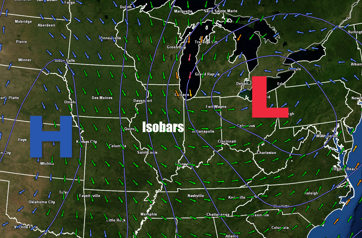
Winds will be gusty today as the isobars tighter up. Isobars are equal lines of pressure. When they tighter up we usually see an increase in winds. Low pressure over the Great Lakes and high pressure moving into the Missouri Valley will cause the isobars to tighter up.
Here is the weather map for later today. See those blue lines? Those are isobars (equal lines of barometric pressure). They are tightly packed over Missouri and Illinois. Thus, winds will increase.
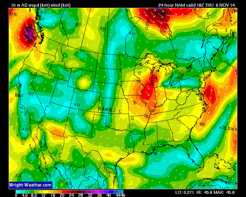
Wind forecast map for later today. The yellow and orange colors represent 15-25 mph winds.
Current regional temperature map

National temperature map

Winds will be gusty today. Here is the wind speed map. This will automatically update through the day.

Track the cloud cover via the infrared satellite.


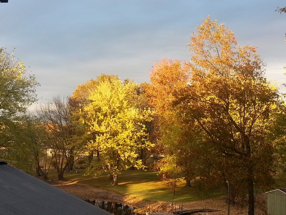
A nice fall photograph from Ursula John Tenz Simpkins

No major changes in the ongoing forecast.

No major concerns with this forecast package. Some gusty winds today. Winds may gust in the 20-25 mph range.

The Wild Card gives you an idea of what might change that would cause the forecast to bust. A busted forecast means a forecast that does not verify. For example, if a winter storm (the area of low pressure) shifts its track 50 miles further south than expected, then that could cause a dramatic change in how much snow might or might not accumulate.
Wild card in this forecast- cloud cover today into Friday. It appears there will be more clouds over our eastern counties than western counties. Somewhere along and east of a line from Mt Vernon, Illinois down towards Metropolis, Illinois and then towards Murray, Kentucky should experience a few more clouds than say southeast Missouri.

Can we expect severe thunderstorms over the next 24 to 48 hours? Remember that a severe thunderstorm is defined as a thunderstorm that produces 58 mph winds or higher, quarter size hail or larger, and/or a tornado.
Severe weather is not going to be a concern through Sunday.
Thunderstorm threat level is zero.


Please visit your local National Weather Service Office by clicking here. The National Weather Service Office, for our region, is located in Paducah, Kentucky.
![]()
We have regional radars and local city radars – if a radar does not seem to be updating then try another one. Occasional browsers need their cache cleared. You may also try restarting your browser. That usually fixes the problem. Occasionally we do have a radar go down. That is why I have duplicates. Thus, if one fails then try another one.
If you have any problems then please send me an email beaudodson@usawx.com
WEATHER RADAR PAGE – Click here —
We also have a new national interactive radar – you can view that radar by clicking here.
Local interactive city radars include St Louis, Mt Vernon, Evansville, Poplar Bluff, Cape Girardeau, Marion, Paducah, Hopkinsville, Memphis, Nashville, Dyersburg, and all of eastern Kentucky – these are interactive radars. Local city radars – click here

Regional Radar – Click on radar to take you our full radar page.


Regional Radar
I have added a lot of new maps to the Southern Illinois Weather Observatory web-site. Check them out by clicking here.

No winter weather concerns. The coldest air of the season appears possible next week. Whether or not precipitation will be associated with the cold blast has yet to be determined.

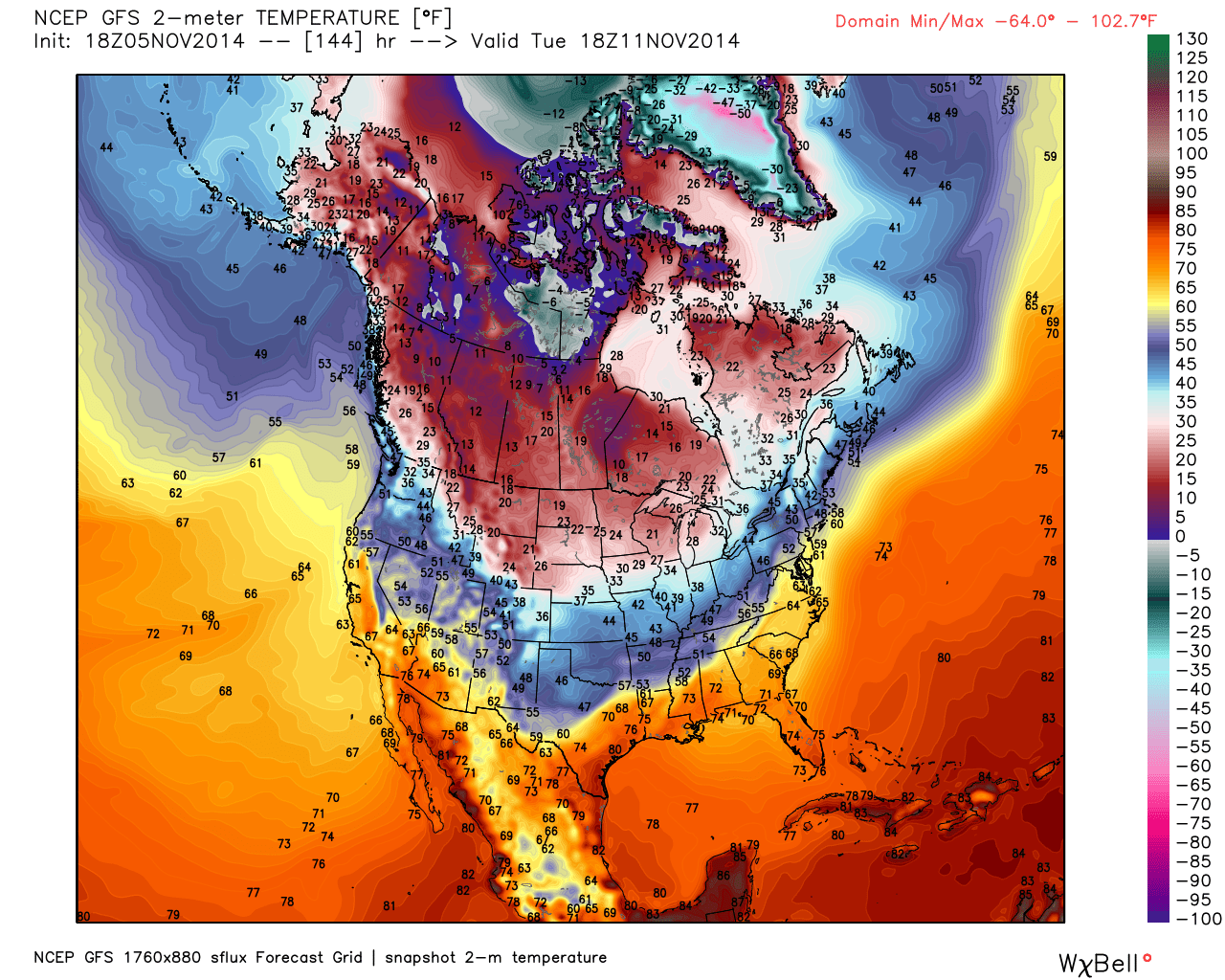
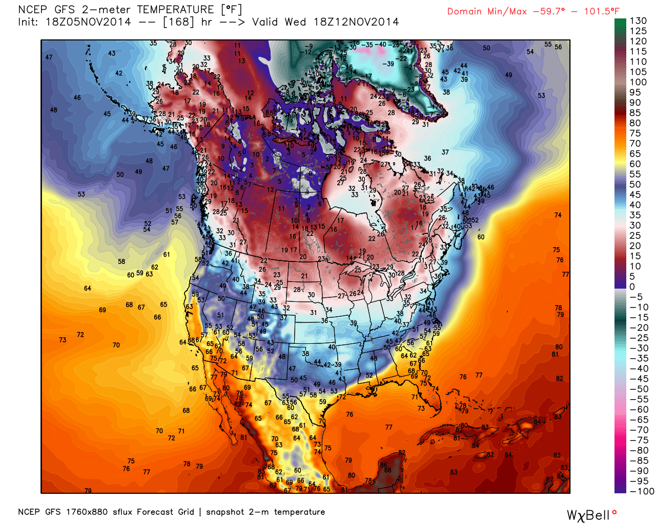
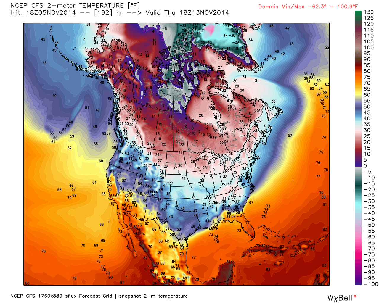
The big story over the coming 2 weeks will be the cold air moving into the eastern half of the United States. Some of the data indicates WELL below normal temperatures for much of our region. Several cold waves will impact the region over the coming 10 day period.
This map is for next Wednesday _November 12th)
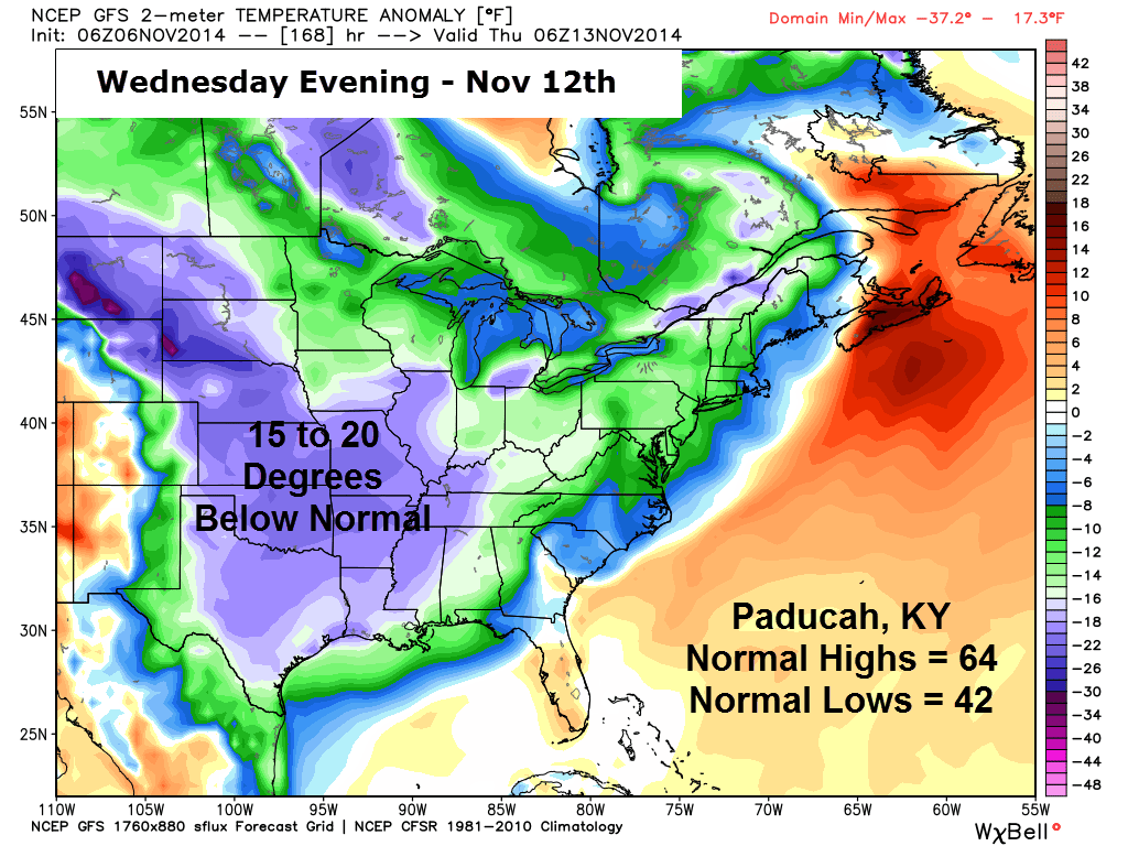
The strongest cold shot will likely occur towards the middle and end of next week. Some data indicates temperatures could fall into the lower 20’s and upper teens over some of our counties. That would be quite early for temperatures that low. Still a long way off and time for changes and adjustments.
Here are some interesting maps illustrating the cold shots that are forecast to occur.
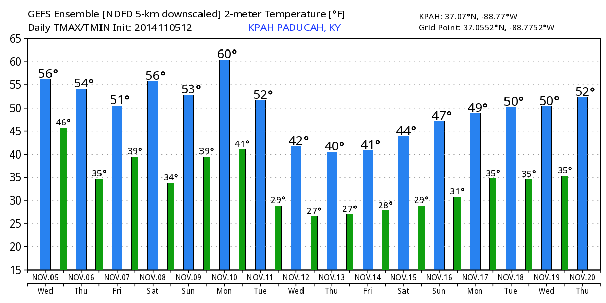
Here is the GFS model forecast for high and low temperatures centered on Paducah, Kentucky. Note that it is indicating temperatures may not get out of the 40’s during the middle and end of next week. Overnight lows on the GFS are down into the 20’s.
The blue lines represent the high temperatures. The green lines represent the low temperatures. The dates can be viewed at the bottom of the graphic.
Again, this is in the long range. Subject to changes.
Temperature map for next Tuesday afternoon. Check out how far south the cold air is going to spread. Impressive for an early season cold outbreak.
Temperature map for next Wednesday afternoon. Again, see how far south this cold air is forecast to spread.
Temperature map for next Thursday afternoon. Brrrr
The latest 6-10 temperature outlook shows that probabilities favor below normal temperatures. The colors represent the % chance for above or below normal temperatures. The dark blue indicates a 50%-70% chance that temperatures will be below normal.


8-14 Day Temperature Outlook – again it appears below normal temperatures will continue for awhile. This map is through November 18th.

Current tower cam view from the Weather Observatory- Click here for all cameras.

Southern Illinois Weather Observatory

Southern Illinois Weather Observatory
WPSD TV 6 has a number of tower cameras. Click here for their tower camera page
& Kentucky Road Conditions & Kentucky Highway and Interstate Cameras

Downtown Paducah, Kentucky
Benton, Kentucky Tower Camera – Click here for full view

Benton, Kentucky
WSIL TV 3 has a number of tower cameras. Click here for their tower camera page
& Illinois Road Conditions

Marion, Illinois

You can sign up for my AWARE email by clicking here I typically send out AWARE emails before severe weather, winter storms, or other active weather situations. I do not email watches or warnings. The emails are a basic “heads up” concerning incoming weather conditions.