We have some great sponsors for the Weather Talk Blog. Please let our sponsors know that you appreciate their support for the Weather Talk Blog.
Milner and Orr Funeral Home and Cremation Services located in Paducah, Kentucky and three other western Kentucky towns – at Milner and Orr they believe in families helping families. You can find Milner and Orr on Facebook, as well.
![]()
.

Wortham Dental Care located in Paducah, Kentucky. The gentle dentist. Mercury free dentistry. They also do safe Mercury removal. You can find Wortham Dental Care on Facebook, as well
.

For all of your families eye care needs. Visit their web-site here. Or, you can also visit their Facebook page.
.

Endrizzi’s Storm Shelters – For more information click here. Endrizzi Contracting and Landscaping can be found on Facebook, as well – click here
.

Best at Enabling Body Shop Profitability since 1996. Located In Paducah Kentucky and Evansville Indiana; serving all customers in between. They provide Customer Service, along with all the tools necessary for body shops to remain educated and competitive. Click the logo above for their main web-site. You can find McClintock Preferred Finishes on Facebook, as well
.

Duck/goose decoys? Game calls? Optics? We have you covered! Click the logo above or visit Final Flight on Facebook, as well.

This forecast update covers far southern Illinois, far southeast Missouri, and far western Kentucky. See the coverage map on the right side of the blog.
Remember that weather evolves. Check back frequently for updates, especially during active weather.
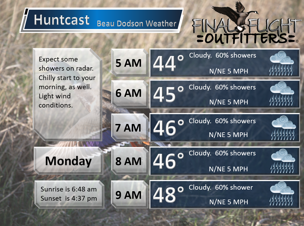
Sunday night – Some cold rain showers. Fog possible.
Temperatures: Lows in upper 30s to lower 40s – temperatures may rise towards morning as a warm front advances through the area.
Winds: North/northeast winds at 6-12 mph.
What is the chance for precipitation? 80%
Coverage of precipitation? Widespread
My confidence in this part of the forecast verifying is Medium
Should I be concerned about snow or ice? No
Should I cancel my outdoor plans? Have a plan B
Is severe weather expected? No
What impact is expected? Wet roadways.
WEATHER RADAR PAGE – Click here —
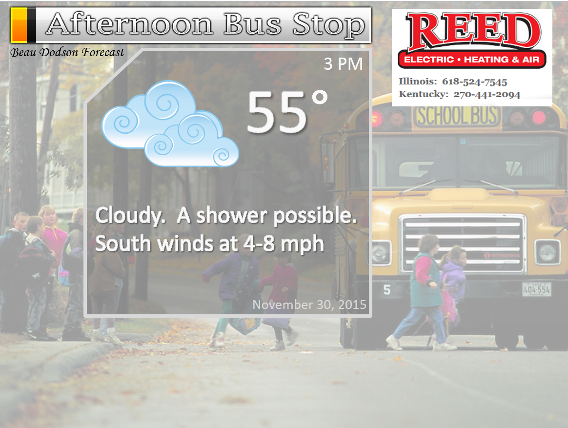
Monday – Cloudy. Some morning fog possible. Rain showers possible.
Temperatures: Highs may reach into the lower 50s ahead of a cold front. Perhaps remaining in the 40s over our far northwest counties.
Winds: East winds ahead of our new storm system. Winds then becoming south and southwest mid-day. Then becoming west towards evening.
What is the chance for precipitation? 60%
Coverage of precipitation? Isolated/scattered early
My confidence in this part of the forecast verifying is Medium
Should I be concerned about snow or ice? No
Should I cancel my outdoor plans? Rain possible.
Is severe weather expected? No
What impact is expected? Wet roadways possible.
Monday night – Cloudy. A chance for a few showers.
Temperatures: Lows in the middle 40s
Winds: West/northwest winds at 6-12 mph.
What is the chance for precipitation? 60%
Coverage of precipitation? Showers possible
My confidence in this part of the forecast verifying is Medium
Should I be concerned about snow or ice? No
Should I cancel my outdoor plans? Some additional showers possible.
Is severe weather expected? No
What impact is expected? Wet roadways.
Tuesday – Cloudy and cool. A chance for morning showers (before 3 am). We might see some clearing during the day.
Temperatures: Highs mostly in the upper 40s
Winds: West/southwest at 6-12 mph with gusts to 20 mph possible.
What is the chance for precipitation? 40% (before 3 am)
Coverage of precipitation? Scattered before 3 am
My confidence in this part of the forecast verifying is Medium
Should I be concerned about snow or ice? No
Should I cancel my outdoor plans? No
Is severe weather expected? No
What impact is expected? Wet roadways possible before 3 am.
Tuesday night – Clearing sky conditions.
Temperatures: Low temperatures in 34 to 38 degree range
Winds: Northeast winds at 6-12 mph.
What is the chance for precipitation? 0%
Coverage of precipitation? None
My confidence in this part of the forecast verifying is High
Should I be concerned about snow or ice? No
Should I cancel my outdoor plans? No
Is severe weather expected? No
What impact is expected? None
Wednesday – A mix of sun and clouds. Fall like.
Temperatures: Highs will range from 44 to 48 degrees
Winds: West/northwest at 4-8 mph
What is the chance for precipitation? 0%
Coverage of precipitation? None
My confidence in this part of the forecast verifying is High
Should I be concerned about snow or ice? No
Should I cancel my outdoor plans? No
Is severe weather expected? No
What impact is expected? None
Wednesday night – Clear and cold.
Temperatures: Lows in the upper 20s to lower 30s
Winds: Northwest winds at 0 to 5 mph.
What is the chance for precipitation? 0%
Coverage of precipitation? None
My confidence in this part of the forecast verifying is High
Should I be concerned about snow or ice? No
Should I cancel my outdoor plans? No
Is severe weather expected? No
What impact is expected? None
Thursday – Mostly sunny. Near normal temperatures for late fall.
Temperatures: Highs in the 52 to 56 degree range
Winds: Northeast winds at 5-10 mph
What is the chance for precipitation? 0%
Coverage of precipitation? None
My confidence in this part of the forecast verifying is High
Should I be concerned about snow or ice? No
Should I cancel my outdoor plans? No
Is severe weather expected? No
What impact is expected? None
Thursday night – Clear and cool
Temperatures: Lows in the upper 20s to lower 30s
Winds: Northeast winds at 6-12 mph.
What is the chance for precipitation? 0%
Coverage of precipitation? None
My confidence in this part of the forecast verifying is High
Should I be concerned about snow or ice? No
Should I cancel my outdoor plans? No
Is severe weather expected? No
What impact is expected? None
Friday – Mostly sunny and cool
Temperatures: Highs in the middle 50s
Winds: East winds at 5 mph
What is the chance for precipitation? 0%
Coverage of precipitation? None
My confidence in this part of the forecast verifying is High
Should I be concerned about snow or ice? No
Should I cancel my outdoor plans? No
Is severe weather expected? No
What impact is expected? None
Friday night – Clear and chilly
Temperatures: Lows in the lower to middle 30s
Winds: Northeast winds at 6-12 mph.
What is the chance for precipitation? 0%
Coverage of precipitation? None
My confidence in this part of the forecast verifying is Medium
Should I be concerned about snow or ice? No
Should I cancel my outdoor plans? No
Is severe weather expected? No
What impact is expected? None
Saturday – Mostly sunny. Just a few clouds. Cool.
Temperatures: Highs in the middle 50s
Winds: East winds at 5-10 mph
What is the chance for precipitation? 0%
Coverage of precipitation? None
My confidence in this part of the forecast verifying is Medium
Should I be concerned about snow or ice? No
Should I cancel my outdoor plans? No
Is severe weather expected? No
What impact is expected? None

Click their ad below to visit their web-site or click here reedelec.com


![]()


Don’t forget to check out the Southern Illinois Weather Observatory web-site for weather maps, tower cams, scanner feeds, radars, and much more! Click here

An explanation of what is happening in the atmosphere over the coming days…
Highlights
1. Scattered rain showers Sunday night into Monday night
2. Cold front arrives on Monday night
3. Rain chances should end by Tuesday
4. Dry conditions expected Tuesday through Sunday
Well, are you tired of the rain yet? Most of you are probably shaking your head with a yes. Most of the holiday weekend has been spent counting raindrops.
I have good news and I have bad news.
The bad news is that we have one more round of showers to go. Another cold front will push through the region on Monday and Monday night. This front will bring an end to our rain chances.
Rainfall totals between now and Monday night should be on the light to moderate side. Far northern counties in southeast Missouri and southern Illinois will likely pick up another 0.25″-0.40″. The rest of southeast Missouri, far southern Illinois, western Kentucky, and northwest Tennessee should pick up 0.40″-0.80″ with locally heavier amounts possible.
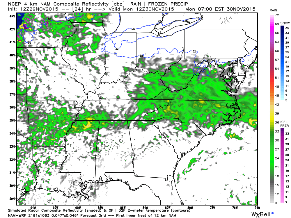
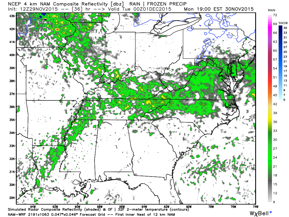
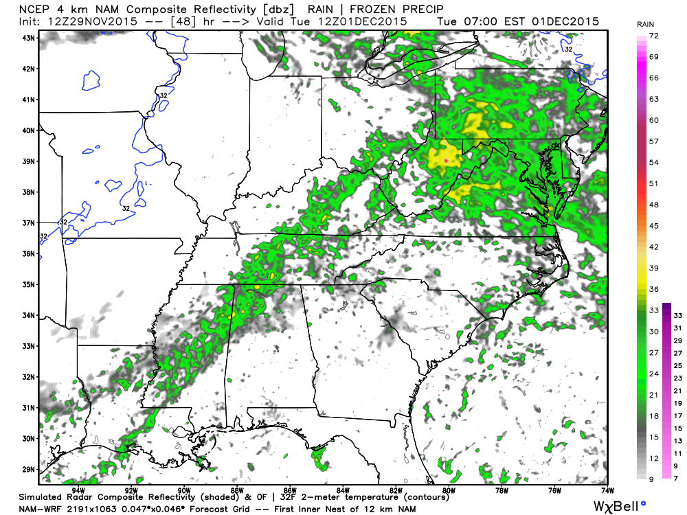
Let’s look at the future-cast radar maps from Weatherbell.com
This may is for Sunday night around 11 pm to 12 am. Some scattered showers in the area
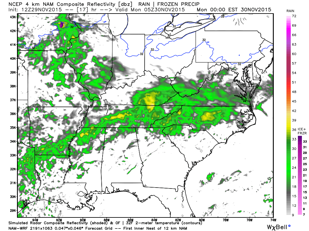
This map is for 6 am Monday morning. Scattered/spotty showers in the area.
This map is for Monday around 11 am. You can see some showers over our area
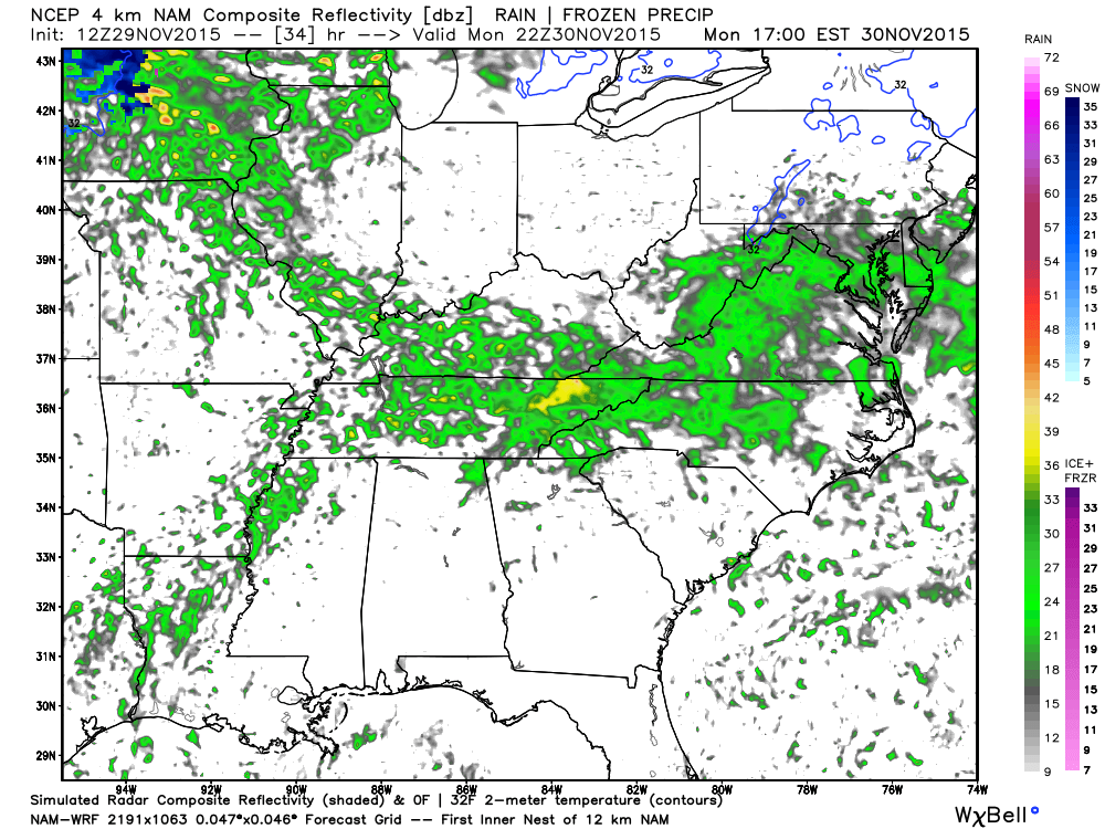
This image is for Monday evening around 6 pm. Still some showers in the area.
This last image is for 6 am on Tuesday morning. Rain should be well off to our east by that time.
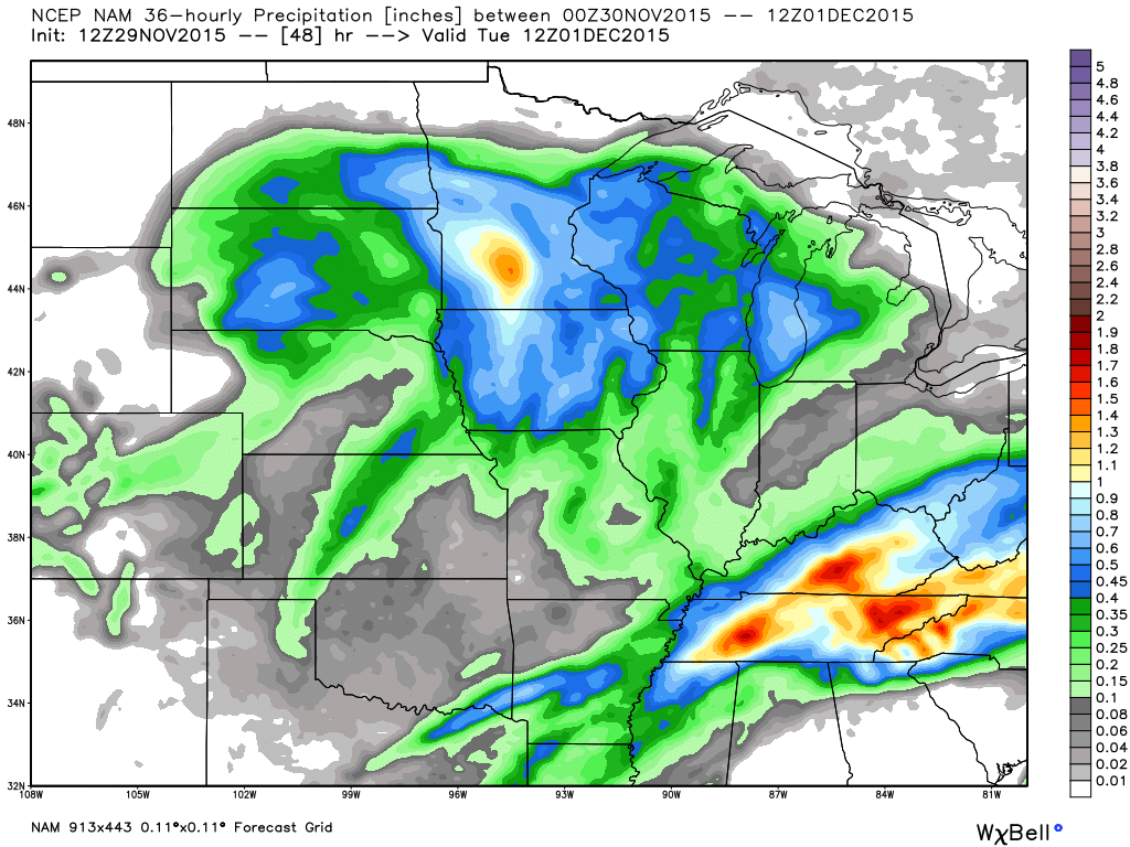
Here is the NAM model guidance rainfall forecast. You can see it indicates more south than north. And, this is what I am expecting, as well. Image is from weatherbell.com and you can click it for a larger view. Scale is on the right side of the image.
Locally heavy amounts are possible on Sunday afternoon/evening over southeast Missouri, western Kentucky, and northwest Tennessee.
The good news is that dry weather will arrive on Tuesday and last into the weekend! The week ahead will be cool, but nothing out of the ordinary. Typical mid to late fall weather.
Click the image for a larger view
I am watching another system for next Sunday night, Monday, or Tuesday. Long way off and confidence is low on the eventual track.
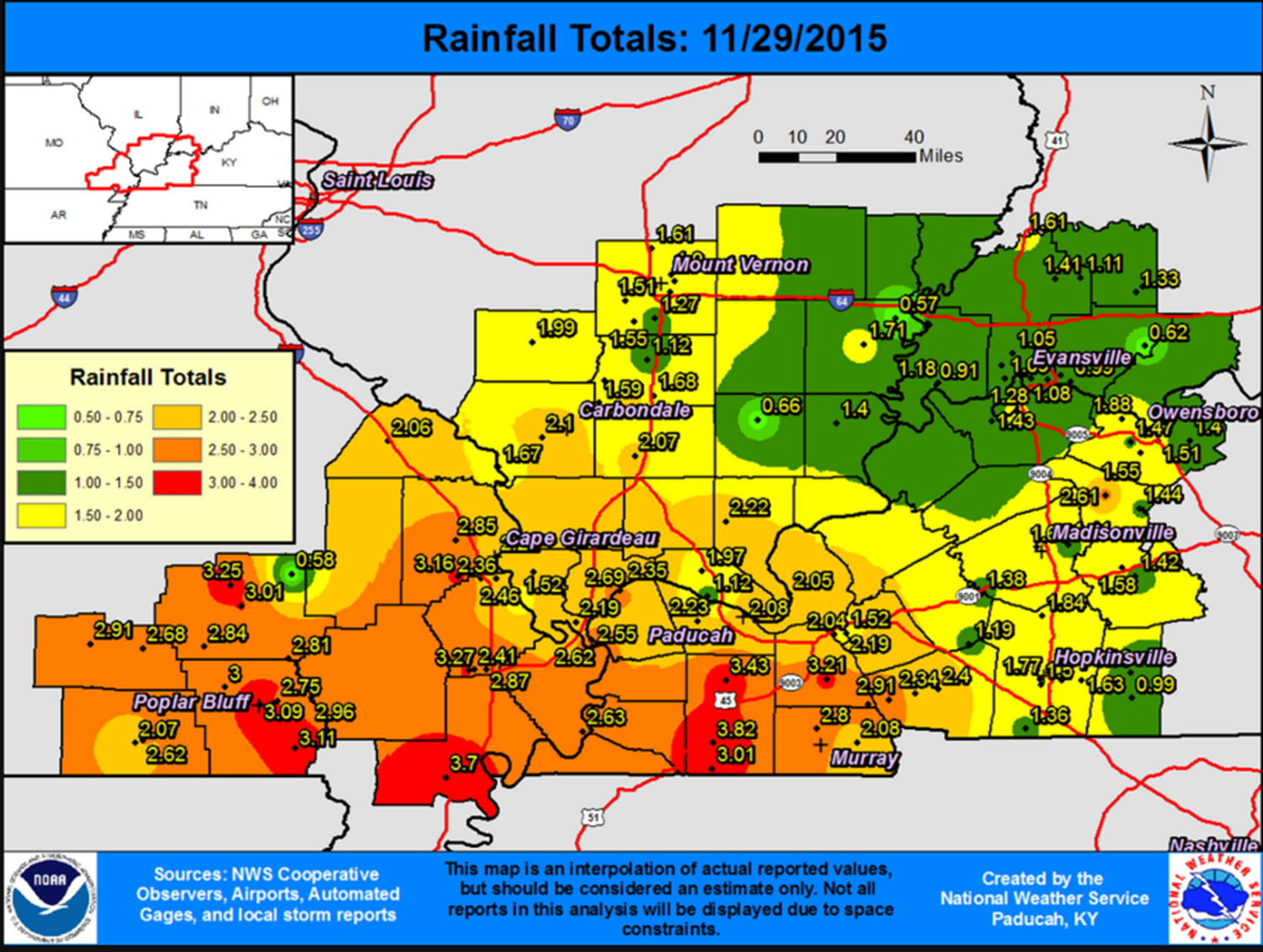
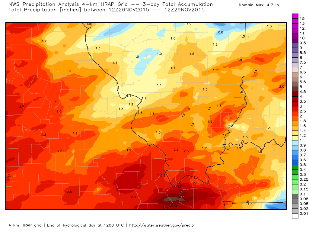
Check out the rainfall totals from the last three days. Just a tad wet out there
Here are some spotter reports from the past three days
Click the image for a larger view. Image is from weatherbell.com


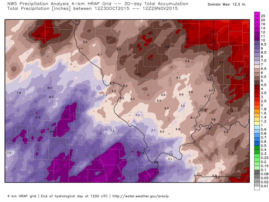
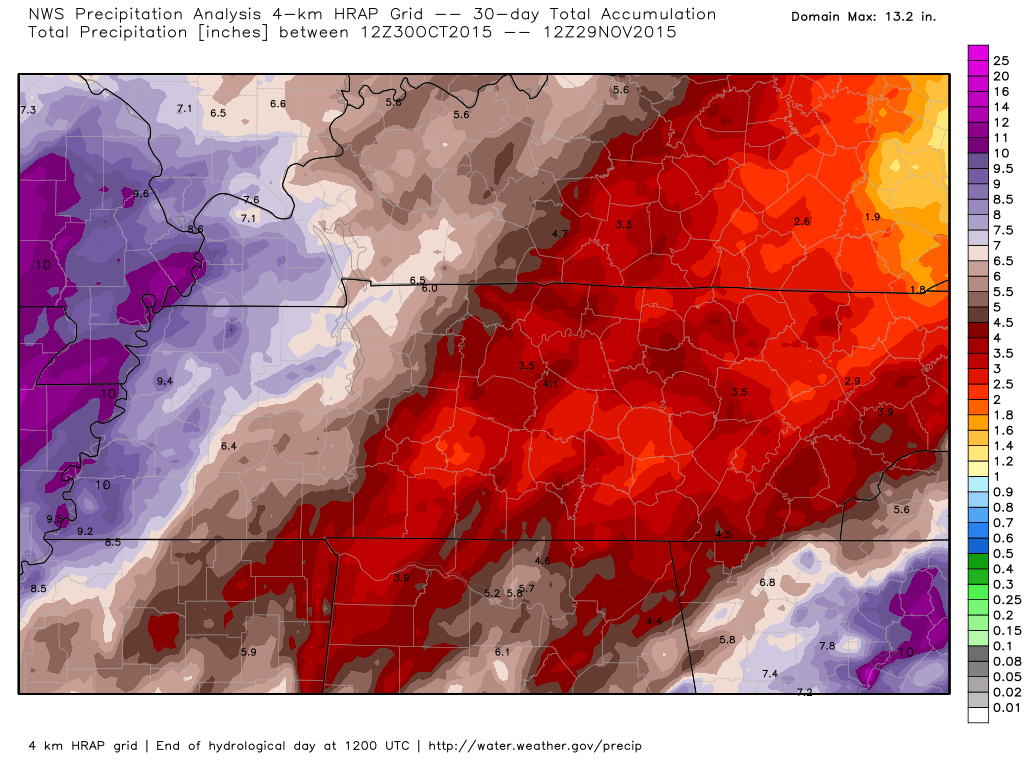
The 30 day totals are also impressive

I am not tracking any snow or ice storms.
Radar

WEATHER RADAR PAGE – Click here —
Click image below for watch or warning information


No snow anticipated.

No frozen precipitation through next Saturday.

No major changes to the forecast.

No major concerns. Still some rises on area rivers and streams.

Might need the umbrella between Sunday night and Monday night. Scattered showers possible.

No wild card in this update.

Frost possible Wednesday, Thursday, and Friday mornings. Will have to monitor for freeze conditions.

How much precipitation should we expect over the next few days?
Additional rainfall totals on Sunday night into Monday should be less than 0.20″

Can we expect severe thunderstorms over the next 24 to 48 hours? Remember that a severe thunderstorm is defined as a thunderstorm that produces 58 mph winds or higher, quarter size hail or larger, and/or a tornado.
The thunderstorm threat level will be ZERO for Sunday night through next Saturday.
.
Monday: Severe weather is not anticipated.
Tuesday: Severe weather is not anticipated.
Wednesday: Severe weather is not anticipated.
Thursday: Severe weather is not anticipated.
Friday: Severe weather is not anticipated.
Saturday: Severe weather is not anticipated.

Here is the official 6-10 day and 8-14 day temperature and precipitation outlook. Check the date stamp at the top of each image (so you understand the time frame).
The forecast maps below are issued by the Weather Prediction Center (NOAA).


The latest 8-14 day temperature and precipitation outlook. Note the dates are at the top of the image. These maps DO NOT tell you how high or low temperatures or precipitation will be. They simply give you the probability as to whether temperatures or precipitation will be above or below normal.


Here are the current river stage forecasts. You can click your state and then the dot for your location. It will bring up the full forecast and hydrograph.
Click Here For River Stage Forecasts…

Who do you trust for your weather information and who holds them accountable?
I have studied weather in our region since the late 1970’s. I have 37 years of experience in observing our regions weather patterns. My degree is in Broadcast Meteorology from Mississippi State University and an Associate of Science (AS). I am currently working on my Bachelor’s Degree in Geoscience.
My resume includes:
Member of the American Meteorological Society.
NOAA Weather-Ready Nation Ambassador.
Meteorologist for McCracken County Emergency Management.
I own and operate the Southern Illinois Weather Observatory.
Recipient of the Mark Trail Award, WPSD Six Who Make A Difference Award, Kentucky Colonel, and the Caesar J. Fiamma” Award from the American Red Cross.
In 2009 I was presented with the Kentucky Office of Highway Safety Award.
Recognized by the Kentucky House of Representatives for my service to the State of Kentucky leading up to several winter storms and severe weather outbreaks.
I am also President of the Shadow Angel Foundation which serves portions of western Kentucky and southern Illinois.
There is a lot of noise on the internet. A lot of weather maps are posted without explanation. Over time you should learn who to trust for your weather information.
My forecast philosophy is simple and straight forward.
- Communicate in simple terms
- To be as accurate as possible within a reasonable time frame before an event
- Interact with you on Twitter, Facebook, and the blog
- Minimize the “hype” that you might see on television or through other weather sources
- Push you towards utilizing wall-to-wall LOCAL TV coverage during severe weather events
I am a recipient of the Mark Trail Award, WPSD Six Who Make A Difference Award, Kentucky Colonel, and the Caesar J. Fiamma” Award from the American Red Cross. In 2009 I was presented with the Kentucky Office of Highway Safety Award. I was recognized by the Kentucky House of Representatives for my service to the State of Kentucky leading up to several winter storms and severe weather outbreaks.
If you click on the image below you can read the Kentucky House of Representatives Resolution.

Many of my graphics are from www.weatherbell.com – a great resource for weather data, model data, and more


You can sign up for my AWARE email by clicking here I typically send out AWARE emails before severe weather, winter storms, or other active weather situations. I do not email watches or warnings. The emails are a basic “heads up” concerning incoming weather conditions.