

.
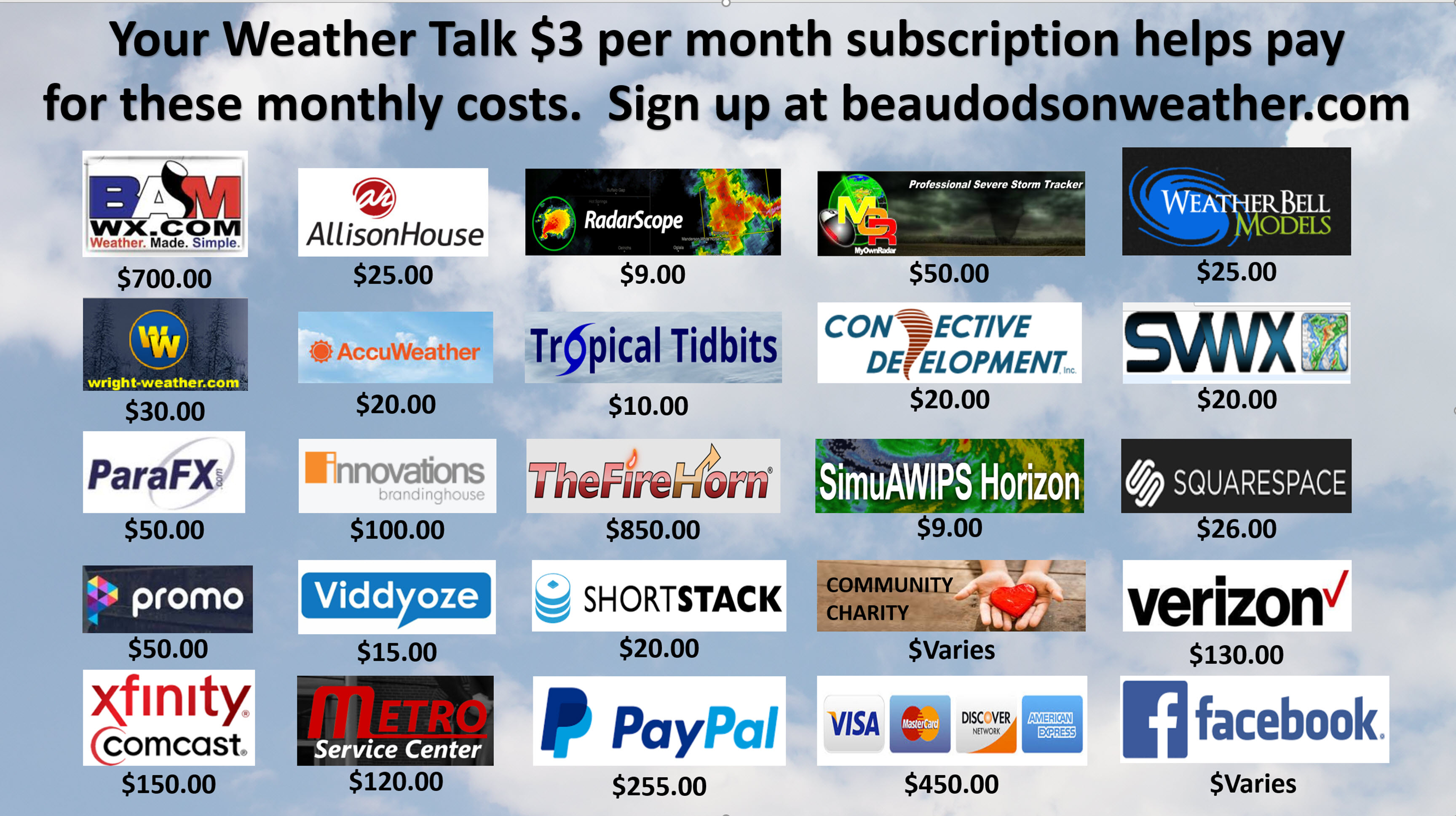
A Weather Talk subscription ($3 a month) is required to view the videos. This helps cover monthly costs (which can run between one and two thousand dollars).
Videos are posted on the www.weathertalk.com website. Once there, click the Beau Video-Cast tab. Long Range Video Update
If you believe you missed a video then you may check the LIVE FEED link on the Weather Talk website. You will find an archive of videos on that page.
You can also receive the videos via your Weather Talk app/text messages. Turn text option FOUR to the on position. The Weather Extra text option. Sign up for the app/text messages, videos, and more at www.beaudodsonweather.com
Your $3 a month helps cover the following monthly costs. These are my out of pocket expenses.
This forecast covers the counties in red. The counties in orange are covered by the forecast discussion further down in the blog.


November 27, 2017
Monday Night Forecast Details:
Forecast: Clear. Not as cold.
Temperatures: MO ~ 38 to 44 IL ~ 38 to 44 KY ~ 38 to 44
Wind chill values: N/A
Accumulating snow or ice: No
Winds: South and southwest at 7 to 14 mph with gusts to 20 mph late (esp over MO/IL)
What impacts are anticipated from the weather? None
My confidence in the forecast verifying: High
Is severe weather expected? No
The NWS defines severe weather as 58 mph wind or great, 1″ hail or larger, and/or tornadoes
Is freezing rain, sleet, or snow expected? No
What is the chance of precipitation? MO ~ 0% IL ~ 0% KY ~ 0%
Coverage of precipitation: None
Should I cancel my outdoor plans: No
.
November 28, 2017
Tuesday Forecast Details
Forecast: Mostly sunny with a few passing clouds. Breezy, at times. Mild with well above normal temperatures.
Temperatures: MO ~ 65 to 70 IL ~ 65 to 68 KY ~ 65 to 68
Wind chill values: N/A
Accumulating snow or ice: No
Winds: South and southwest at 7 to 14 mph with gusts to 25 mph
What impacts are anticipated from the weather? None.
My confidence in the forecast verifying: High
Is severe weather expected? No
The NWS defines severe weather as 58 mph wind or great, 1″ hail or larger, and/or tornadoes
Is freezing rain, sleet, or snow expected? No
What is the chance of precipitation? MO ~ 0% IL ~ 0% KY ~ 0%
Coverage of precipitation: None
Should I cancel my outdoor plans? No
.
Tuesday Night Forecast Details:
Forecast: Becoming partly cloudy. Cool.
Temperatures: MO ~ 40 to 45 IL ~ 40 to 45 KY ~ 40 to 45
Wind chill values: N/A
Accumulating snow or ice: No
Winds: South and southwest at 5 to 10 mph
What impacts are anticipated from the weather? None
My confidence in the forecast verifying: High
Is severe weather expected? No
The NWS defines severe weather as 58 mph wind or great, 1″ hail or larger, and/or tornadoes
Is freezing rain, sleet, or snow expected? No
What is the chance of precipitation? MO ~ 20% IL ~ 10% KY ~ 10%
Coverage of precipitation: None to isolated
Should I cancel my outdoor plans: No
.
November 29, 2017
Wednesday Forecast Details
Forecast: Mostly sunny with some occasional clouds. Mild.
Temperatures: MO ~ 62 to 66 IL ~ 63 to 66 KY ~ 63 to 66
Wind chill values: N/A
Accumulating snow or ice: No
Winds: South and southwest at 5 to 10 mph with gusts to 12 mph
What impacts are anticipated from the weather? Most likely none
My confidence in the forecast verifying: High
Is severe weather expected? No
The NWS defines severe weather as 58 mph wind or great, 1″ hail or larger, and/or tornadoes
Is freezing rain, sleet, or snow expected? No
What is the chance of precipitation? MO ~ 20% IL ~ 10% KY ~ 10%
Coverage of precipitation: Isolated (if any at all)
Should I cancel my outdoor plans? No
.
Wednesday Night Forecast Details:
Forecast: Becoming cloudy. Cool. Widely scattered late night showers.
Temperatures: MO ~ 44 to 48 IL ~ 44 to 48 KY ~ 44 to 48
Wind chill values: N/A
Accumulating snow or ice: No
Winds: South and southeast winds at 5 to 10 mph with gusts to 15 mph
What impacts are anticipated from the weather? Wet roadways are possible late
My confidence in the forecast verifying: High
Is severe weather expected? No
The NWS defines severe weather as 58 mph wind or great, 1″ hail or larger, and/or tornadoes
Is freezing rain, sleet, or snow expected? No
What is the chance of precipitation? MO ~ 40% IL ~ 40% KY ~ 40%
Coverage of precipitation: Widely scattered (mostly late)
Should I cancel my outdoor plans: No
.
November 30, 2017
Thursday Forecast Details
Forecast: Partly to mostly cloudy. Scattered rain showers possible.
Temperatures: MO ~ 56 to 62 IL ~ 56 to 60 KY ~ 56 to 62
Wind chill values: N/A
Accumulating snow or ice: No
Winds: South and southwest winds becoming west and northwest at 5 to 10 mph with gusts to 15 mph
What impacts are anticipated from the weather? Wet roadways.
My confidence in the forecast verifying: Medium
Is severe weather expected? No
The NWS defines severe weather as 58 mph wind or great, 1″ hail or larger, and/or tornadoes
Is freezing rain, sleet, or snow expected? No
What is the chance of precipitation? MO ~ 50% IL ~ 50% KY ~ 50%
Coverage of precipitation: Widely scattered to scattered. A band of light rain possible in the region.
Should I cancel my outdoor plans? Monitor radars
.
Thursday Night Forecast Details:
Forecast: Clouds clearing. Cooler.
Temperatures: MO ~ 30 to 35 IL ~ 28 to 34 KY ~ 30 to 35
Wind chill values: N/A
Accumulating snow or ice: No
Winds: North at 5 to 10 mph
What impacts are anticipated from the weather? Patchy fog possible.
My confidence in the forecast verifying: High
Is severe weather expected? No
The NWS defines severe weather as 58 mph wind or great, 1″ hail or larger, and/or tornadoes
Is freezing rain, sleet, or snow expected? No
What is the chance of precipitation? MO ~ 0% IL ~ 0% KY ~ 10%
Coverage of precipitation: Ending
Should I cancel my outdoor plans: No
.
December 1, 2017
Friday Forecast Details
Forecast: Mostly sunny. Cool.
Temperatures: MO ~ 50 to 55 IL ~ 50 to 55 KY ~ 50 to 55
Wind chill values: N/A
Accumulating snow or ice: No
Winds: Variable at 5 to 10 mph
What impacts are anticipated from the weather? None
My confidence in the forecast verifying: Medium
Is severe weather expected? No
The NWS defines severe weather as 58 mph wind or great, 1″ hail or larger, and/or tornadoes
Is freezing rain, sleet, or snow expected? No
What is the chance of precipitation? MO ~ 0% IL ~ 0% KY ~ 0%
Coverage of precipitation: None
Should I cancel my outdoor plans? No
.
Friday Night Forecast Details:
Forecast: Mostly clear and chilly.
Temperatures: MO ~ 30 to 35 IL ~ 30 to 35 KY ~ 30 to 35
Wind chill values: N/A
Accumulating snow or ice: No
Winds: North at 4 to 8 mph
What impacts are anticipated from the weather? None
My confidence in the forecast verifying: High
Is severe weather expected? No
The NWS defines severe weather as 58 mph wind or great, 1″ hail or larger, and/or tornadoes
Is freezing rain, sleet, or snow expected? No
What is the chance of precipitation? MO ~ 0% IL ~ 0% KY ~ 0%
Coverage of precipitation: None
Should I cancel my outdoor plans: No
.
December 2, 2017
Saturday Forecast Details
Forecast: Partly to mostly sunny.
Temperatures: MO ~ 54 to 58 IL ~ 54 to 58 KY ~ 54 to 58
Wind chill values: N/A
Accumulating snow or ice: No
Winds: West and southwest at 5 to 10 mph with gusts to 14 mph
What impacts are anticipated from the weather? None
My confidence in the forecast verifying: High
Is severe weather expected? No
The NWS defines severe weather as 58 mph wind or great, 1″ hail or larger, and/or tornadoes
Is freezing rain, sleet, or snow expected? No
What is the chance of precipitation? MO ~ 0% IL ~ 0% KY ~ 0%
Coverage of precipitation: None
Should I cancel my outdoor plans? No
.
Saturday Night Forecast Details:
Forecast: Mostly clear and cool.
Temperatures: MO ~ 34 to 38 IL ~ 34 to 38 KY ~ 34 to 38
Wind chill values: N/A
Accumulating snow or ice: No
Winds: West and southwest at 4 to 8 mph
What impacts are anticipated from the weather? None
My confidence in the forecast verifying: Medium
Is severe weather expected? No
The NWS defines severe weather as 58 mph wind or great, 1″ hail or larger, and/or tornadoes
Is freezing rain, sleet, or snow expected? No
What is the chance of precipitation? MO ~ 0% IL ~ 0% KY ~ 0%
Coverage of precipitation: None
Should I cancel my outdoor plans: No
.
December 3, 2017
Sunday Forecast Details
Forecast: Mostly sunny. Warmer.
Temperatures: MO ~ 58 to 64 IL ~ 58 to 62 KY ~ 58 to 62
Wind chill values: N/A
Accumulating snow or ice: No
Winds: East winds becoming more southerly at 5 to 10 mph
What impacts are anticipated from the weather? None
My confidence in the forecast verifying: Medium
Is severe weather expected? No
The NWS defines severe weather as 58 mph wind or great, 1″ hail or larger, and/or tornadoes
Is freezing rain, sleet, or snow expected? No
What is the chance of precipitation? MO ~ 0% IL ~ 0% KY ~ 0%
Coverage of precipitation: None
Should I cancel my outdoor plans? No
.
Sunday Night Forecast Details:
Forecast: Partly cloudy and cool.
Temperatures: MO ~ 40 to 45 IL ~ 40 to 45 KY ~ 40 to 45
Wind chill values: N/A
Accumulating snow or ice: No
Winds: Southwest at 4 to 8 mph
What impacts are anticipated from the weather? None
My confidence in the forecast verifying: Medium
Is severe weather expected? No
The NWS defines severe weather as 58 mph wind or great, 1″ hail or larger, and/or tornadoes
Is freezing rain, sleet, or snow expected? No
What is the chance of precipitation? MO ~ 0% IL ~ 0% KY ~ 0%
Coverage of precipitation: None
Should I cancel my outdoor plans: No
.
December 4, 2017
Monday Forecast Details
Forecast: Mostly sunny. Warmer.
Temperatures: MO ~ 58 to 64 IL ~ 58 to 62 KY ~ 58 to 62
Wind chill values: N/A
Accumulating snow or ice: No
Winds: Southerly at 5 to 10 mph with gusts to 15 mph
What impacts are anticipated from the weather? None
My confidence in the forecast verifying: Low
Is severe weather expected? No
The NWS defines severe weather as 58 mph wind or great, 1″ hail or larger, and/or tornadoes
Is freezing rain, sleet, or snow expected? No
What is the chance of precipitation? MO ~ 0% IL ~ 0% KY ~ 0%
Coverage of precipitation: Most likely none
Should I cancel my outdoor plans? No
.
Monday Night Forecast Details:
Forecast: Partly cloudy.
Temperatures: MO ~ 40 to 45 IL ~ 40 to 45 KY ~ 40 to 45
Wind chill values: N/A
Accumulating snow or ice: No
Winds: South at 6 to 12 mph
What impacts are anticipated from the weather?
My confidence in the forecast verifying: Low
Is severe weather expected? No
The NWS defines severe weather as 58 mph wind or great, 1″ hail or larger, and/or tornadoes
Is freezing rain, sleet, or snow expected? No
What is the chance of precipitation? MO ~ 10% IL ~ 10% KY ~ 10%
Coverage of precipitation:
Should I cancel my outdoor plans:
.
December 54, 2017
Tuesday Forecast Details
Forecast: Partly cloudy. Showers possible.
Temperatures: MO ~ 60 to 65 IL ~ 60 to 65 KY ~ 60 to 65
Wind chill values: N/A
Accumulating snow or ice: No
Winds:
What impacts are anticipated from the weather?
My confidence in the forecast verifying: Low
Is severe weather expected? No
The NWS defines severe weather as 58 mph wind or great, 1″ hail or larger, and/or tornadoes
Is freezing rain, sleet, or snow expected? No
What is the chance of precipitation? MO ~ 30% IL ~ 30% KY ~ 30%
Coverage of precipitation:
Should I cancel my outdoor plans?
.
Tuesday Night Forecast Details:
Forecast: Cloudy. A chance of showers.
Temperatures: MO ~ 40 to 45 IL ~ 40 to 45 KY ~ 40 to 45
Wind chill values: N/A
Accumulating snow or ice: No
Winds:
What impacts are anticipated from the weather?
My confidence in the forecast verifying: Low
Is severe weather expected? No
The NWS defines severe weather as 58 mph wind or great, 1″ hail or larger, and/or tornadoes
Is freezing rain, sleet, or snow expected? No
What is the chance of precipitation? MO ~ 30% IL ~ 30% KY ~ 30%
Coverage of precipitation:
Should I cancel my outdoor plans:
.

.
Tuesday through Monday: Accumulating snow or ice is not anticipated.
.

The National Weather Service definition of a severe thunderstorm is one that produces quarter size hail or larger, 58 mph winds or greater, and/or a tornado.
Tuesday through Sunday: No severe weather.
.

Weather Highlights:
Short range forecast.
High confidence.
More nice weather ahead of us.
Temperatures have been unusually warm over the last few days. I have not heard too many complaints. The winter snow crowd isn’t happy, but they have plenty of time to think about snow.
With that said, meteorological winter does begin December 1st (meteorologist consider DEC through JAN as winter).
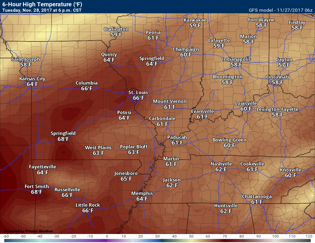
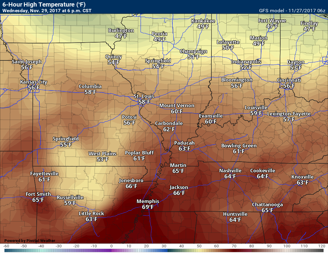
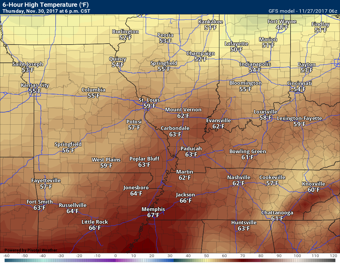
We will have more of the same today into Thursday. Mild days and cool nights. Highs today through Thursday will likely top out in the 60’s.
These next four graphics are the GFS high temperature maps.
The GFS might be a little too cool today. We will see how it goes.
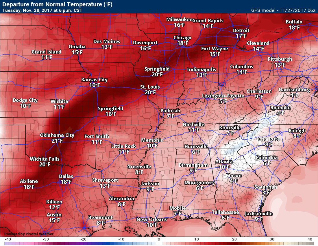
Tuesday highs
.
.
Wednesday highs
Clouds may shave a few degrees off on Wednesday. Some debate about that.
.
.
Thursday highs
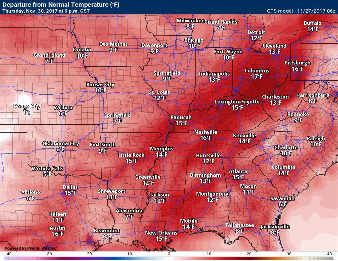
Clouds will shave several degrees off the Thursday high temperatures. Rain showers, as well. GFS does continue the idea of at least lower 60’s ahead of our cold front.
.
.
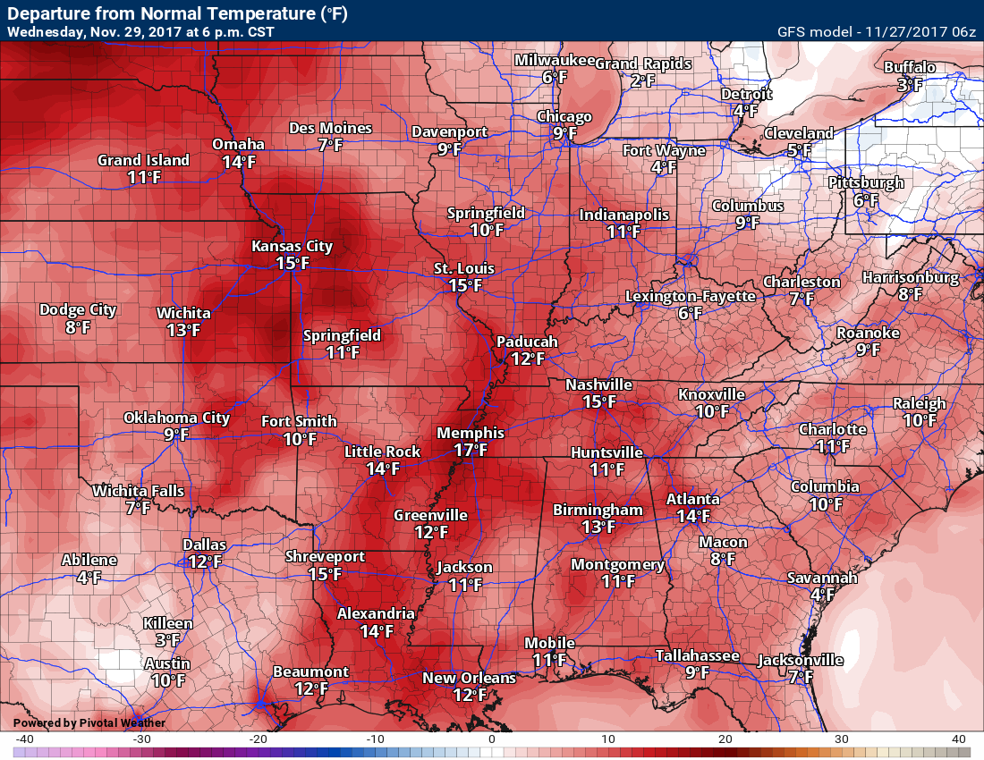
Here are the temperature anomaly maps for Tuesday through Thursday.
These graphics show you how many degrees above normal temperatures will be. Several!
Tuesday
.
.
Wednesday
.
.
Thursday
.
.
Lows Tuesday morning and Wednesday morning will generally be in the lower 40’s. Lows Thursday morning will likely be in the middle to upper 40’s. Lows by Friday, Saturday, and Sunday morning will be in the lower to middle 30’s. Friday will be the coldest morning.
We will remain dry today through Wednesday morning.
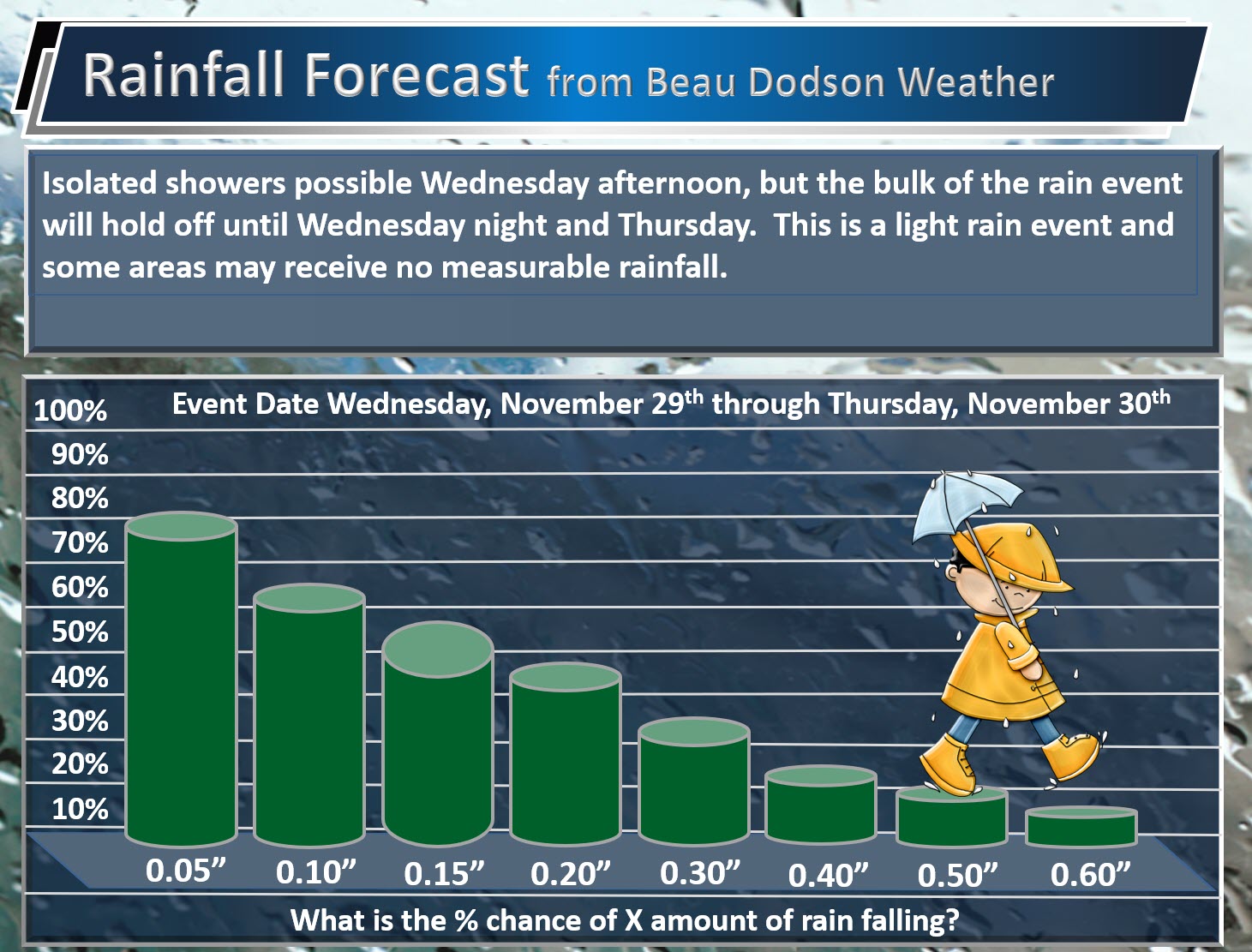
A few isolated showers can’t be ruled out Wednesday afternoon. Scattered showers are possible Wednesday night into Thursday.
Some areas may receive no measurable rainfall.
Wednesday rain chance will be around 20%
Wednesday night rain chances will be around 40%
Thursday rain chances will be from 40% to 50%.
Thursday night rain chances will drop to below 20%
Here is my rainfall forecast.
What is the % chance of X amount of rain falling. Note, some areas may miss out on measurable rainfall.
.
.
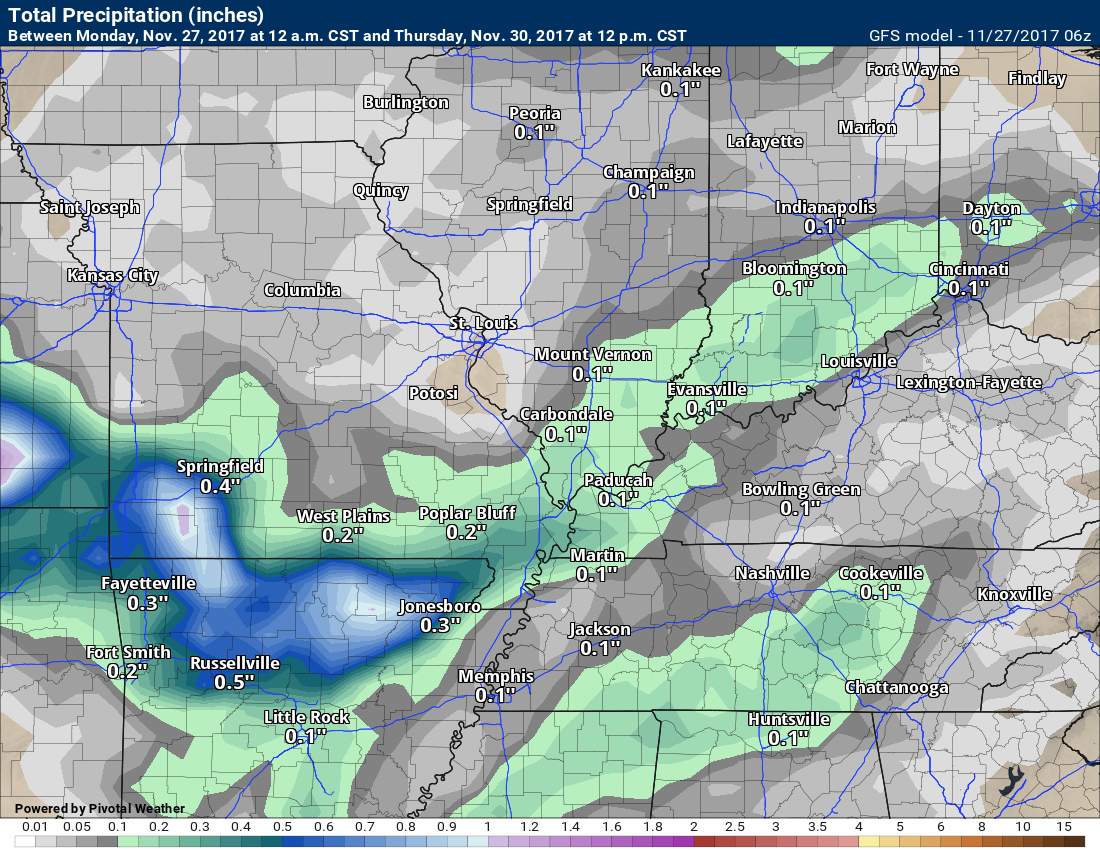
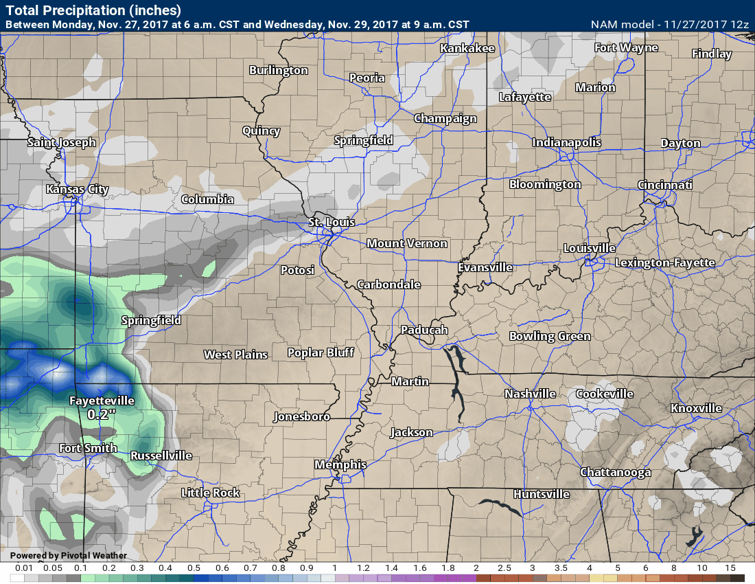
Here are the model guidance forecast packages for rainfall totals.
GFS
.
.
NAM
.
Here is the NAM animation of rainfall totals through 6 pm on Thursday. Not much.
.
Click to enlarge
.
Friday into Sunday will deliver slightly cooler temperatures and dry conditions.
Highs will be in the fifties and lows will be in the thirties.
Long Range
Low confidence
Some interesting weather changes ahead of us.
A sharp cold snap is possible as we move towards the second week of December. How long that cold snap lasts is still a question.
There are many signals pointing towards a thunderstorm event around December 5th or 6th (give or take). I have been monitoring this system for over two weeks.
A deep area of low pressure may develop across the Central United States. This low would move to our northwest. This keeps us on the warm side of the system.
The end result would be a surge in temperatures, dew points, and PWAT values. PWAT’s represent all of the moisture in the atmospheric column above you. The higher the PWAT values the greater the risk for locally heavy rain.
Models are signalling for a possible heavy rain event. This is in the long range, so confidence is low (for now).
There is some chance of another system developing to our south behind this one.
Sharply colder air would follow the system.
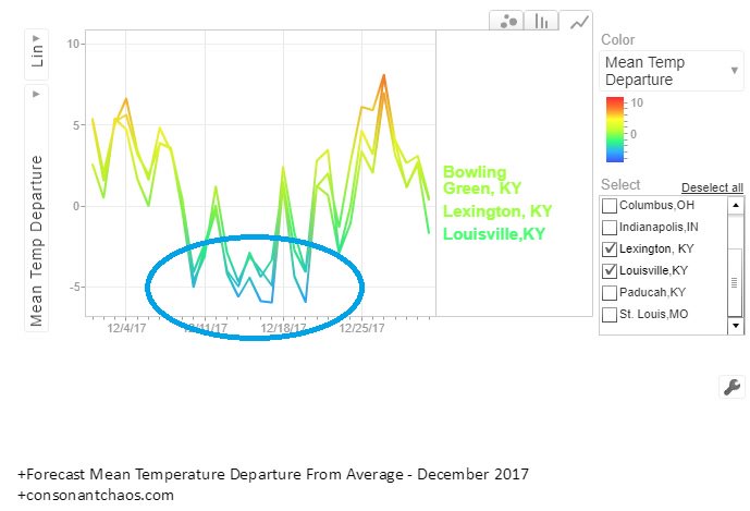
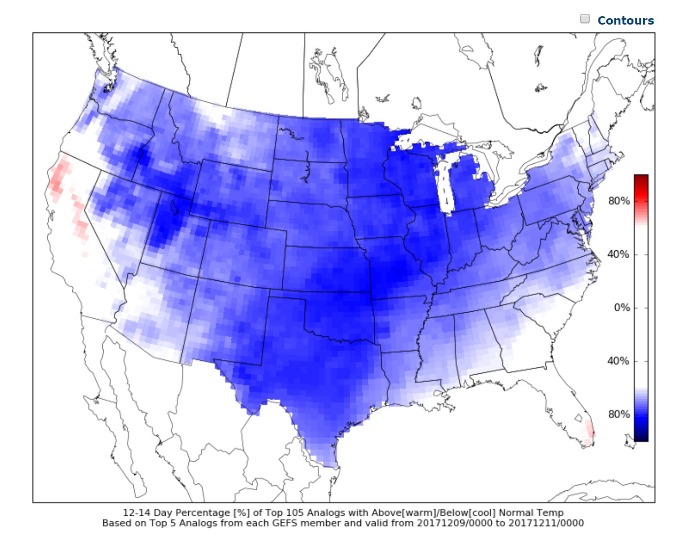
Some of the long range guidance tools have indicated a cold snap during the middle of December.
Here is one of those tools.
The cold snap has been circled. The left side scale represents temperature departures. The bottom scale represents the date.
.
.
The real question will be whether any moisture can interact with this cold snap. It is still too soon to know the answer to that question.
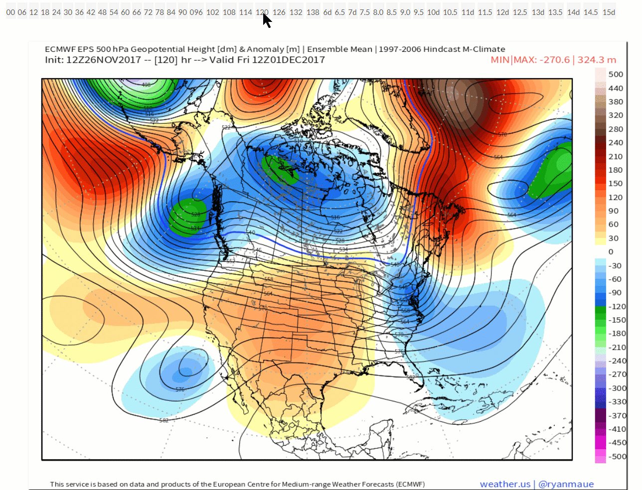
The upper air charts also show this cold snap.
Here is an animation from the EC guidance. Blue represents colder air. You can see it dump into the US behind the storm system.
You may click on the GIF animation for a larger view.
The moving hand represents hours. You can see the date on the graphic as it moves forward in time.
Orange and red represents higher heights and blue and green represents lower heights. Those are what determine our surface temperature.
Notice how the lines dive from northwest to southeast with the blue colors. That would be the colder air from Canada moving into the United States.
Again, click the image for the larger view (I made it small because it takes time to load on some computers/devices).
.
.
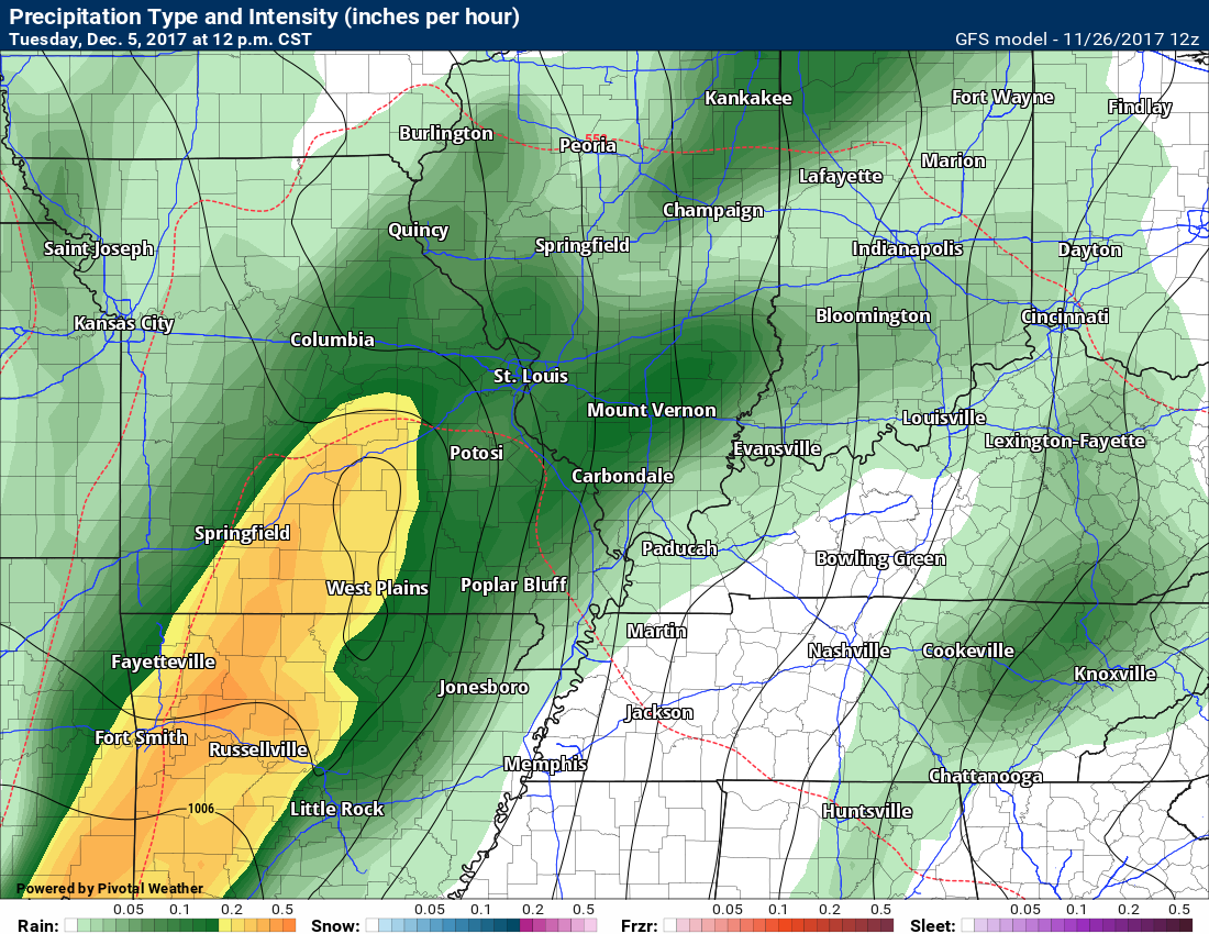
The GFS guidance is picking up on a system around December 5th/6th.
Here is what the GFS is showing for December 5th.
Heavy rain over portions of Missouri (in yellow). This would move east/northeast.
Long way out for details. I am just showing you the general idea that there could be a system to monitor in that time frame.
Specifics are far from certain this far out.
See the black lines? Those are isobars. Equal lines of pressure. When they are tightly packed together we end up with gusty winds. This could be a gusty wind event. Time will tell.
.
.
Here is a zoomed out view
This is for 12 AM on Wednesday, December 6th. This is the GFS model guidance.
The low is centered over northeast Nebraska. A cold front trails through Illinois to the Gulf of Mexico. Rain in our region. Heavy snow/blizzard over the Dakota’s. Blue would be snow. Green would be rain.
.
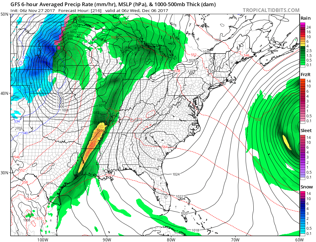
The Monday morning run showed a cold front, but no deep low. Basically, I am watching the 5th or 6th for a storm system of some type. For now, it looks to be a rain event.
There may be a second system around the 9th through 11th.
.
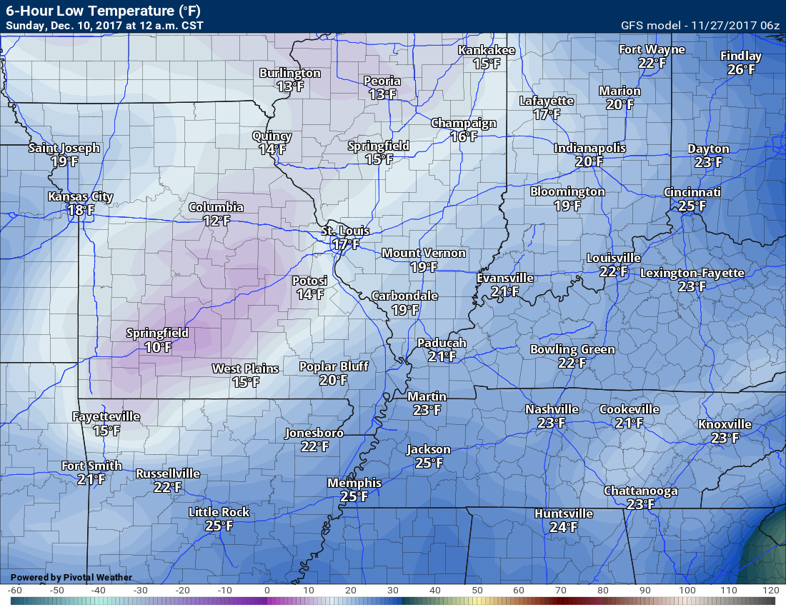
I will be monitoring both that storm system and the cold snap.
The GFS shows the cold air on December 9th and 10th. This is the 12 AM map for December 10th.
.
.
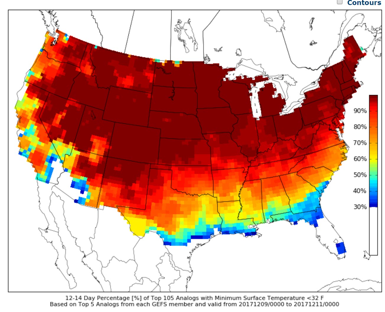
CIPS analog forecast graphics also show the sharp cold snap after the 8th.
Ths map shows you below normal temperatures over most of the USA.
.
.
What is the probability of temperatures being 32 degrees or colder?
.
.
Are you subscribing to Weather Talk app/text messages and videos? This is what helps support all of the data you see each day.
We now offer premium videos for the short and long-range forecasts! These videos are produced by a team of long-range forecast experts. They are brought to you as bonus information. Activate text option four in order to receive these on your app or via text.
Subscribe at www.beaudodsonweather.com
We offer an Apple and Android app (scroll to the bottom of this page for more information).

Were you aware that I hired a team of meteorologists for long range videos?
To learn more, click this link
http://cms.weathertalk.com/meet-the-team/
.


We offer regional radars and local city radars – if a radar does not update then try another one. Occasional browsers need their cache cleared. You may also try restarting your browser. This will usually fix any problems.
During the winter you can track snow and ice by clicking the winterize button on the local city view interactive radars.
You may email me at beaudodson@usawx.com
Interactive Weather Radar Page. Choose the city nearest your location: Click this link
National interactive radar: Click this link.
The Beau Dodson Weather APP is ready for Apple and Android users. The app provides a faster way for you to receive my text messages. ATT and Verizon are not always reliable when it comes to speed.
Some of you have asked if you can receive the texts on your phone and the app. The answer to that is, yes. The Android app will automatically allow that to happen. On the Apple app, however, you will need to open your app and click the settings button. Make sure the green tab is OFF. Off means you will still receive the texts to your phone and the app. If you have any questions, then email me at beaudodson@usawx.com
The app is for text subscribers.
The direct download, for the Apple app, can be viewed here
https://itunes.apple.com/us/app/id1190136514
Here is the download link for the Android version Click Here
If you have not signed up for the texting service then you may do so at www.beaudodsonweather.com


——————————————————–
Your support helps with the following:

and

.

Whom do you trust for your weather information?
I have studied weather, in our region, since the late 1970’s. I have 40 years of experience in observing our regions weather patterns. My degree is in Broadcast Meteorology and a Bachelor’s of Science.
My resume includes:
Member of the American Meteorological Society.
NOAA Weather-Ready Nation Ambassador.
Meteorologist for McCracken County Emergency Management. I served from 2005 through 2015.
Meteorologist for McCracken County Rescue. 2015 through current
I own and operate the Southern Illinois Weather Observatory.
I am the chief meteorologist for Weather Talk LLC.
I am also a business owner in western Kentucky.
Recipient of the Mark Trail Award, WPSD Six Who Make A Difference Award, Kentucky Colonel, and the Caesar J. Fiamma” Award from the American Red Cross.
In 2005, I helped open the largest American Cross shelter in U.S. history. This was in Houston, Texas. I was deployed to help with the aftermath of Hurricane Katrina and Hurricane Rita. I was a shelter manager of one of the Houston, Texas shelter divisions.
In 2009 I was presented with the Kentucky Office of Highway Safety Award.
Recognized by the Kentucky House of Representatives for my service to the State of Kentucky leading up to several winter storms and severe weather outbreaks.
If you click on the image below you can read the Kentucky House of Representatives Resolution.

I am President of the Shadow Angel Foundation which serves portions of western Kentucky and southern Illinois.
There is a lot of noise on the internet. A lot of weather maps are posted without explanation. You need a trusted source for information.
My forecast philosophy is simple and straight forward.
- Communicate in simple terms
- To be as accurate as possible within a reasonable time frame before an event
- Interact with you on Twitter, Facebook, email, texts, and this blog
- Minimize the “hype” that you might see through other weather sources
- Push you towards utilizing wall-to-wall LOCAL TV coverage during severe weather events

Sign up for my AWARE email by clicking here.
I typically send AWARE emails before severe weather, winter storms, or other active weather situations. I do not email watches or warnings. The emails are a basic “heads up” concerning incoming weather conditions