
WeatherTalk monthly operating costs can top $2000.00. Your $5 subscription helps pay for those costs. I work for you.
The $5 will allow you to register up to seven phones!
For $5 a month you can receive the following. You may choose to receive these via your WeatherTalk app or regular text messaging.
Severe weather app/text alerts from my keyboard to your app/cell phone. These are hand typed messages from me to you. During tornado outbreaks, you will receive numerous app/text messages telling you exactly where the tornado is located.
- Daily forecast app/texts from my computer to your app/cell phone.
- Social media links sent directly to your app/cell phone. When I update the blog, videos, or Facebook you will receive the link.
- AWARE emails. These emails keep you well ahead of the storm. They give you several days of lead time before significant weather events.
- Direct access to Beau via text and email. Your very own personal meteorologist. I work for you!
- Missouri and Ohio Valley centered video updates
- Long-range weather videos
- Week one, two, three and four temperature and precipitation outlooks.
Monthly outlooks. - Your subscription also will help support several local charities.
Would you like to subscribe? Subscribe at www.beaudodsonweather.com
Typical progression on a severe weather day for subscribers.


I encourage subscribers to use the app vs regular text messaging. We have found text messaging to be delayed during severe weather. The app typically will receive the messages instantly. I recommend people have three to four methods of receiving their severe weather information.
Remember, my app and text alerts are hand typed and not computer generated. You are being given my personal attention during significant weather events.

WWW.WEATHERTALK.COM subscribers, here is my day to day schedule for your weather products.
These are bonus videos and maps for subscribers. I bring these to you from the BAMwx team. I pay them to help with videos.
The Ohio and Missouri Valley videos cover most of our area. They do not have a specific Tennessee Valley forecast but may add one in the future.
The long-range video is technical. Over time, you can learn a lot about meteorology from the long range video. Just keep in mind, it is a bit more technical.


Subscribe at www.weathertalk.com
![]()

November 27, 2018
Tuesday forecast: Partly sunny. Flurries where clouds prevail. There could be more clouds over parts of southeast Illinois and northwest Kentucky. Clouds should clear as we move into the late morning hours. Chilly. Well below normal temperatures. Perhaps some patchy morning fog.
My confidence in the forecast verifying: High (70% confidence)
Temperature range: MO ~ 33 to 36 IL ~ 33 to 36 KY ~ 33 to 36 TN ~ 35 to 40
Wind chill (feels like) temperature forecast: 30 to 40
What is the chance/probability of precipitation? MO ~ 0% IL ~ 20% KY ~ 20% TN ~ 0%
Coverage of precipitation: None
Is flooding anticipated? No
Is accumulating snow or ice anticipated? No
Is non-accumulating snow or ice anticipated? Flurries possible over SE Illinois and NW Kentucky
Are icy road conditions anticipated? No
Wind direction and speed: West and northwest at 5 to 10 mph
What impacts are anticipated from the weather? Monitor patchy morning fog. Remember, during the cold season we can have fog that causes patchy ice spots on bridges and overpasses.
Is severe weather expected? No
The NWS officially defines severe weather as 58 mph wind or great, 1″ hail or larger, and/or tornadoes
Will lightning be possible? No
Should I cancel my outdoor plans? No
Will the weather impact my outdoor plans? It will be uncomfortable outside because of the cold temperatures.
UV Index: 3 Moderate
Sunrise: 6:47 AM
Tuesday Night Forecast Details:
Forecast: Mostly clear. Colder. Patchy fog possible.
My confidence in the forecast verifying: High (70% confidence)
Temperature range: MO ~ 16 to 24 IL ~ 18 to 24 KY ~ 18 to 24 TN ~ 22 to 24
Wind chill (feels like) temperature forecast: 10 to 20
What is the chance/probability of precipitation? MO ~ 0% IL ~ 0% KY ~ 0% TN ~ 0%
Coverage of precipitation: None
Is flooding anticipated? No
Is accumulating snow or ice anticipated? No
Is non-accumulating snow or ice anticipated? No
Are icy road conditions anticipated? No
Wind direction and speed: West and northwest at 4 to 8 mph
What impacts are anticipated from the weather? None
Is severe weather expected? No
The NWS officially defines severe weather as 58 mph wind or great, 1″ hail or larger, and/or tornadoes
Will lightning be possible? No
Should I cancel my outdoor plans? No
Will the weather impact my outdoor plans? Low temperatures will make it feel uncomfortable.
Sunset: 4:38 PM
Moonrise: 9:25 PM Waning Gibbous
Moonset: 11:02 AM
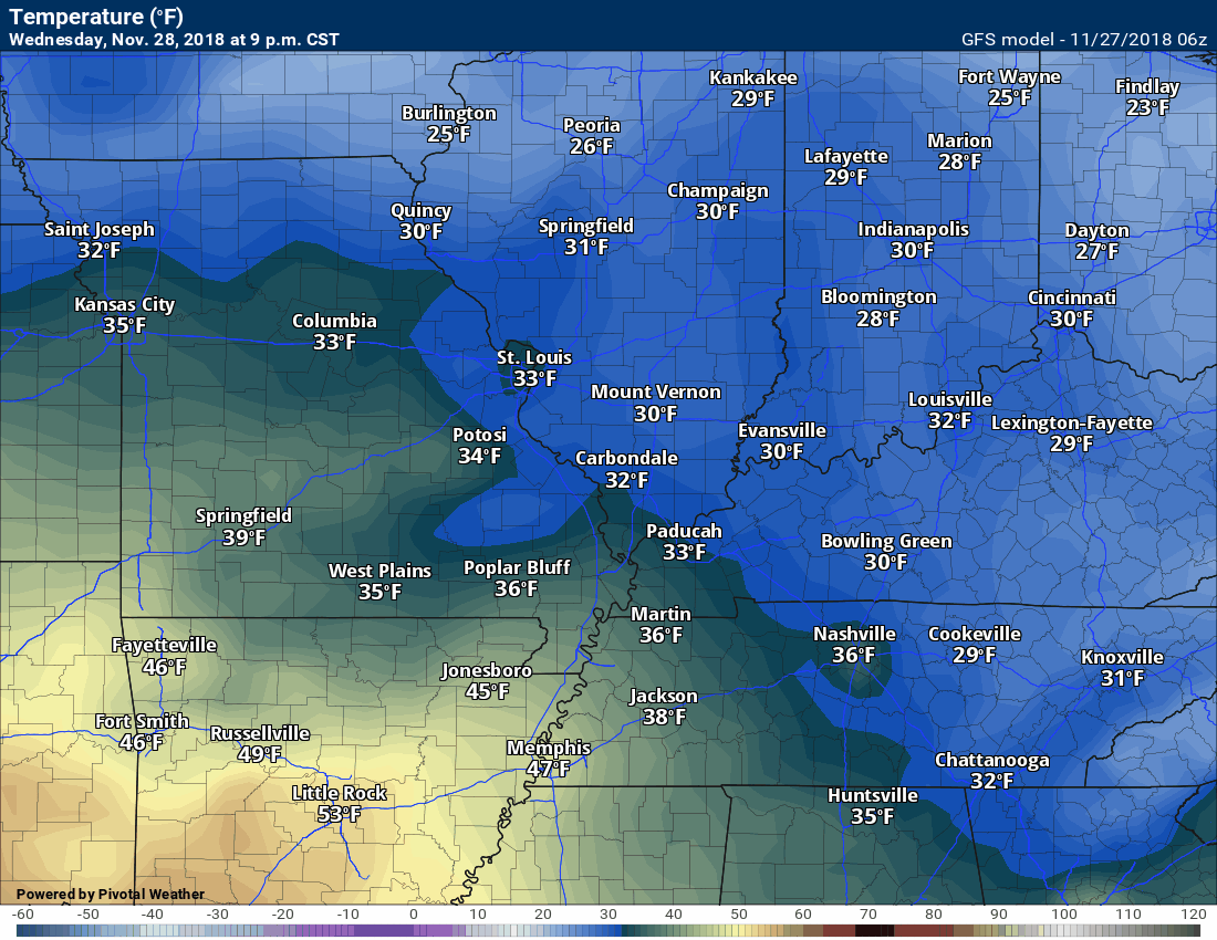
November 28, 2018
Wednesday forecast: Intervals of clouds. Cold. Well below normal temperatures.
My confidence in the forecast verifying: High (70% confidence)
Temperature range: MO ~ 36 to 44 IL ~ 36 to 42 KY ~ 38 to 44 TN ~ 38 to 44
Wind chill (feels like) temperature forecast: 30 to 40
What is the chance/probability of precipitation? MO ~ 0% IL ~ 0% KY ~ 0% TN ~ 0%
Coverage of precipitation: None
Is flooding anticipated? No
Is accumulating snow or ice anticipated? No
Is non-accumulating snow or ice anticipated? No
Are icy road conditions anticipated? No
Wind direction and speed: North at 5 to 10 mph
What impacts are anticipated from the weather? None
Is severe weather expected? No
The NWS officially defines severe weather as 58 mph wind or great, 1″ hail or larger, and/or tornadoes
Will lightning be possible? No
Should I cancel my outdoor plans? No
Will the weather impact my outdoor plans? Once again, cold temperatures will make it uncomfortable.
UV Index: 3 Moderate
Sunrise: 6:48 AM
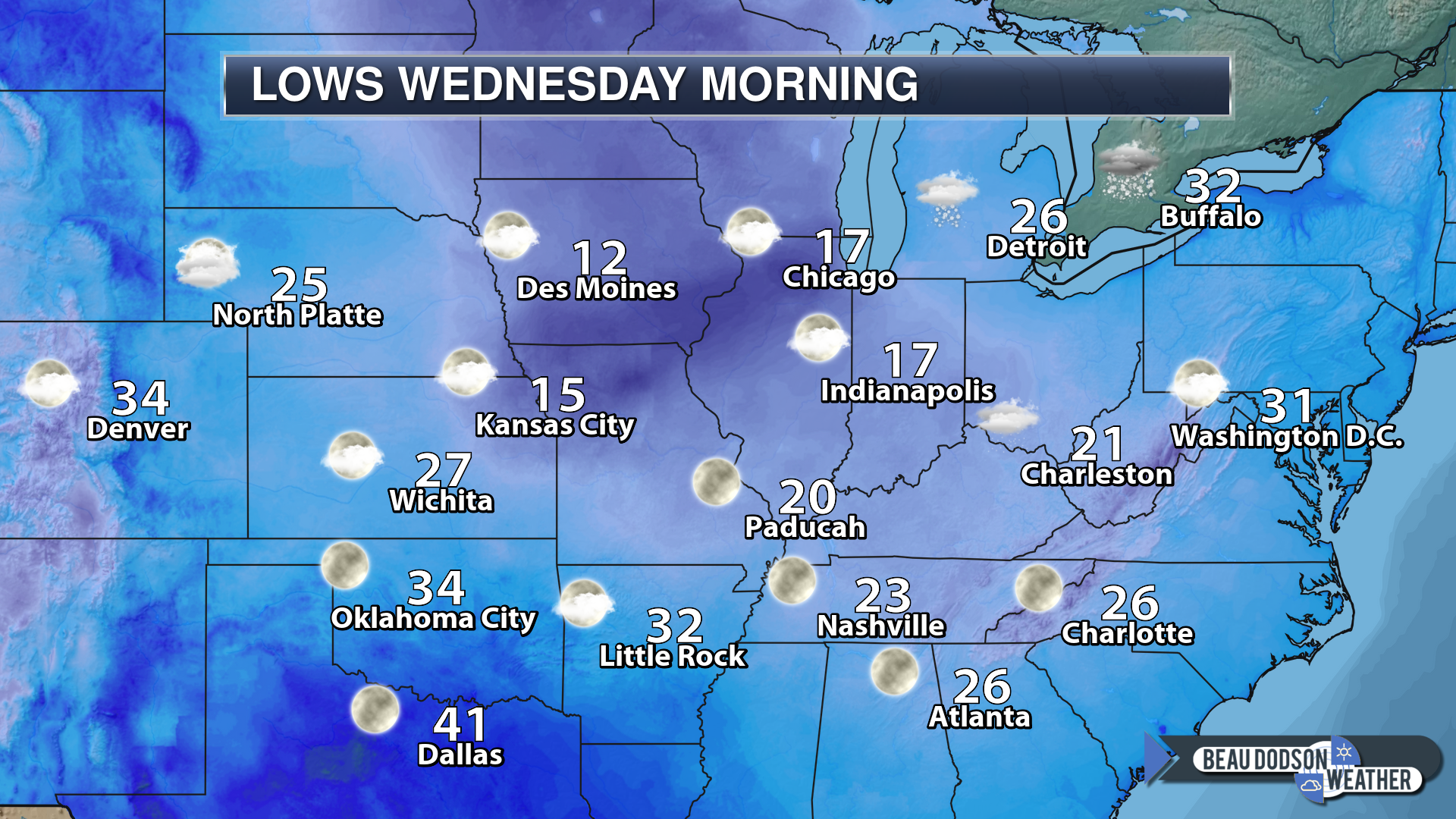
Wednesday Night Forecast Details:
Forecast: Some increasing clouds overnight. Cold.
My confidence in the forecast verifying: High (70% confidence)
Temperature range: MO ~ 26 to 30 IL ~ 26 to 30 KY ~ 26 to 32 TN ~ 28 to 32
Wind chill (feels like) temperature forecast: 20 to 30
What is the chance/probability of precipitation? MO ~ 10% IL ~ 0% KY ~ 0% TN ~ 0%
Coverage of precipitation: Most likely none
Is flooding anticipated? No
Is accumulating snow or ice anticipated? No
Is non-accumulating snow or ice anticipated? No
Are icy road conditions anticipated? No
Wind direction and speed: Becoming east and southeast at 5 to 10 mph
What impacts are anticipated from the weather? None
Is severe weather expected? No
The NWS officially defines severe weather as 58 mph wind or great, 1″ hail or larger, and/or tornadoes
Will lightning be possible? No
Should I cancel my outdoor plans? No
Will the weather impact my outdoor plans? None
Sunset: 4:38 PM
Moonrise: 10:33 PM Waning Gibbous
Moonset: 11:49 AM
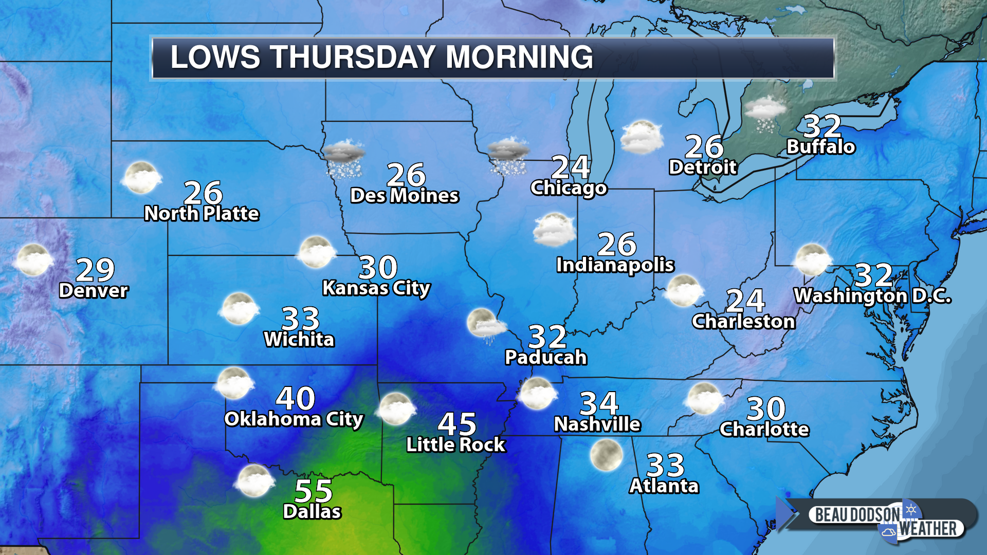
November 29, 2018
Thursday forecast: Intervals of clouds. Not quite as cold. A weak and fast-moving system will push across the area. I can’t rule out a light shower.
My confidence in the forecast verifying: Medium (60% confidence)
Temperature range: MO ~ 52 to 56 IL ~ 52 to 56 KY ~ 52 to 56 TN ~ 52 to 56
Wind chill (feels like) temperature forecast: N/A
What is the chance/probability of precipitation? MO ~ 20% IL ~ 20% KY ~ 20% TN ~ 20%
Coverage of precipitation: None to isolated
Is flooding anticipated? No
Is accumulating snow or ice anticipated? No
Is non-accumulating snow or ice anticipated? No
Are icy road conditions anticipated? No
Wind direction and speed: Southeast and south at 6 to 12 mph
What impacts are anticipated from the weather? Most likely none. Small chance of some wet roadways.
Is severe weather expected? No
The NWS officially defines severe weather as 58 mph wind or great, 1″ hail or larger, and/or tornadoes
Will lightning be possible? No
Should I cancel my outdoor plans? No
Will the weather impact my outdoor plans? Most likely none
UV Index: 1 to 2 Low
Sunrise: 6:49 AM
Thursday Night Forecast Details:
Forecast: Mostly cloudy. A shower possible.
My confidence in the forecast verifying: Medium (40% confidence)
Temperature range: MO ~ 36 to 44 IL ~ 36 to 42 KY ~ 42 to 45 TN ~ 444 to 48
Wind chill (feels like) temperature forecast: 30 to 40
What is the chance/probability of precipitation? MO ~ 40% IL ~ 40% KY ~ 40% TN ~ 40%
Coverage of precipitation: Scattered
Is flooding anticipated? No
Is accumulating snow or ice anticipated? No
Is non-accumulating snow or ice anticipated? No
Are icy road conditions anticipated? No
Wind direction and speed: South to southwest at 5 to 10 mph
What impacts are anticipated from the weather? A few wet roadways.
Is severe weather expected? No
The NWS officially defines severe weather as 58 mph wind or great, 1″ hail or larger, and/or tornadoes
Will lightning be possible? No
Should I cancel my outdoor plans? I would monitor updates and radars.
Will the weather impact my outdoor plans? A few rain showers could cause damp conditions.
Sunset: 4:38 PM
Moonrise: 11:41 PM Waning Gibbous
Moonset: 12:29 PM
November 30, 2018
Friday forecast: A mix of sun and clouds. A shower possible.
My confidence in the forecast verifying: Medium (40% confidence)
Temperature range: MO ~ 60 to 65 IL ~ 54 to 56 KY ~ 56 to 62 TN ~ 58 to 64
Wind chill (feels like) temperature forecast: N/A
What is the chance/probability of precipitation? MO ~ 30% IL ~ 30% KY ~ 50% TN ~ 50%
Coverage of precipitation: Widely scattered
Is flooding anticipated? No
Is accumulating snow or ice anticipated? No
Is non-accumulating snow or ice anticipated? No
Are icy road conditions anticipated? No
Wind direction and speed: South and southwest at 7 to 14 mph
What impacts are anticipated from the weather? Perhaps some wet roadways.
Is severe weather expected? No
The NWS officially defines severe weather as 58 mph wind or great, 1″ hail or larger, and/or tornadoes
Will lightning be possible? No
Should I cancel my outdoor plans? No, but I would monitor updates and radars.
Will the weather impact my outdoor plans? Damp conditions if showers develop. Still some questions on the timing of our next rain system.
UV Index: 1 to 2 Low
Sunrise: 6:50 AM
Friday Night Forecast Details:
Forecast: Cloudy showers likely. A thunderstorm possible. Moderate to heavy rain.
My confidence in the forecast verifying: Medium (60% confidence)
Temperature range: MO ~ 50 to 55 IL ~ 50 to 55 KY ~ 52 to 56 TN ~ 53 to 56
Wind chill (feels like) temperature forecast: N/A
What is the chance/probability of precipitation? MO ~ 70% IL ~ 70% KY ~ 70% TN ~ 70%
Coverage of precipitation: Numerous
Is flooding anticipated? No
Is accumulating snow or ice anticipated? No
Is non-accumulating snow or ice anticipated? No
Are icy road conditions anticipated? No
Wind direction and speed: East and southeast at 7 to 14 mph with gusts to 20 mph
What impacts are anticipated from the weather? Wet roadways. Monitoring the chance of lightning.
Is severe weather expected? Unlikely
The NWS officially defines severe weather as 58 mph wind or great, 1″ hail or larger, and/or tornadoes
Will lightning be possible? Perhaps
Should I cancel my outdoor plans? Have a plan B and monitor updates.
Will the weather impact my outdoor plans? Rain showers will be an issue (esp AM hours).
Sunset: 4:37 PM
Moonrise: 11:59 PM Last Quarter
Moonset: 1:06 PM
December 1, 2018
Saturday forecast: Mostly cloudy. Showers and thunderstorms likely before 1 PM. Diminishing precipitation coverage through the day. Locally heavy downpours possible.
My confidence in the forecast verifying: Medium (60% confidence)
Temperature range: MO ~ 62 to 66 IL ~ 62 to 66 KY ~ 62 to 66 TN ~ 62 to 66
Wind chill (feels like) temperature forecast: N/A
What is the chance/probability of precipitation? MO ~ 70% IL ~ 70% KY ~ 70% TN ~ 70%
Coverage of precipitation: Perhaps numerous.
Is flooding anticipated? Some ditches and low-land flooding possible.
Is accumulating snow or ice anticipated? No
Is non-accumulating snow or ice anticipated? No
Are icy road conditions anticipated? No
Wind direction and speed: Southwest and south at 10 to 20 mph with gusts to 30 mph
What impacts are anticipated from the weather? Wet roadways. Lightning. I can’t rule out some strong thunderstorms. Monitor this part of the forecast.
Is severe weather expected? Low risk. Monitor updates.
The NWS officially defines severe weather as 58 mph wind or great, 1″ hail or larger, and/or tornadoes
Will lightning be possible? Yes.
Should I cancel my outdoor plans? Monitor updates and consider a plan B.
Will the weather impact my outdoor plans? Wet outdoor conditions could be an issue. I am monitoring the risk of lightning, as well.
UV Index: 1 Low
Sunrise: 6:51 AM
Saturday Night Forecast Details:
Forecast: Some clouds. Clearing overnight. Patchy fog possible.
My confidence in the forecast verifying: Medium (60% confidence)
Temperature range: MO ~ 38 to 44 IL ~ 38 to 44 KY ~ 44 to 48 TN ~ 44 to 48
Wind chill (feels like) temperature forecast: 30 to 40
What is the chance/probability of precipitation? MO ~ 0% IL ~ 0% KY ~ 0% TN ~ 0%
Coverage of precipitation: Precipitation should have ended
Is flooding anticipated? Some ditches and low-land flooding possible from the rainfall over the previous 24 hours.
Is accumulating snow or ice anticipated? No
Is non-accumulating snow or ice anticipated? No
Are icy road conditions anticipated? No
Wind direction and speed: South to west at 10 to 20 mph
What impacts are anticipated from the weather? Patchy fog possible if winds die down.
Is severe weather expected? No
The NWS officially defines severe weather as 58 mph wind or great, 1″ hail or larger, and/or tornadoes
Will lightning be possible? No
Should I cancel my outdoor plans? No
Will the weather impact my outdoor plans? Most likely none, unless fog forms.
Sunset: 4:37 PM
Moonrise: 12:47 AM Waning Crescent
Moonset: 1:39 PM
December 2, 2018
Sunday forecast: Partly sunny.
My confidence in the forecast verifying: Medium (50% confidence)
Temperature range: MO ~ 53 to 56 IL ~ 53 to 56 KY ~ 53 to 56 TN ~ 53 to 56
Wind chill (feels like) temperature forecast: N/A
What is the chance/probability of precipitation? MO ~ 0% IL ~ 10% KY ~ 10% TN ~ 0%
Coverage of precipitation: Most likely none
Is flooding anticipated? No
Is accumulating snow or ice anticipated? No
Is non-accumulating snow or ice anticipated? No
Are icy road conditions anticipated? No
Wind direction and speed: West at 6 to 12 mph with gusts to 18 mph
What impacts are anticipated from the weather? None
Is severe weather expected? No
The NWS officially defines severe weather as 58 mph wind or great, 1″ hail or larger, and/or tornadoes
Will lightning be possible? No
Should I cancel my outdoor plans? No
Will the weather impact my outdoor plans? No major impacts.
UV Index: 3 Moderate
Sunrise: 6:52 AM
Sunday Night Forecast Details:
Forecast: Some increase in clouds. I will be monitoring another rain system to the southwest.
My confidence in the forecast verifying: Medium (50% confidence)
Temperature range: MO ~ 35 to 40 IL ~ 35 to 40 KY ~ 35 to 40 TN ~ 35 to 40
Wind chill (feels like) temperature forecast: 30 to 35
What is the chance/probability of precipitation? MO ~ 20% IL ~ 20% KY ~ 20% TN ~ 20%
Coverage of precipitation: Monitor updates
Is flooding anticipated? No
Is accumulating snow or ice anticipated? No
Is non-accumulating snow or ice anticipated? No
Are icy road conditions anticipated? No
Wind direction and speed: South at 6 to 12 mph
What impacts are anticipated from the weather? I will be monitoring rain chances.
Is severe weather expected? No
The NWS officially defines severe weather as 58 mph wind or great, 1″ hail or larger, and/or tornadoes
Will lightning be possible? No
Should I cancel my outdoor plans? No
Will the weather impact my outdoor plans? No major concerns.
Sunset: 4:37 PM
Moonrise: 1:53 AM Waning Gibbous
Moonset: 2:11 PM
December 3, 2018
Monday forecast: Cloudy. Showers possible. I am monitoring another cold front that may arrive Monday. If so, rain would again become widespread. Active pattern underway.
My confidence in the forecast verifying: Medium (50% confidence)
Temperature range: MO ~ 48 to 56 IL ~ 48 to 55 KY ~ 53 to 56 TN ~ 54 to 56
Wind chill (feels like) temperature forecast: N/A
What is the chance/probability of precipitation? MO ~ 30% IL ~ 30% KY ~ 30% TN ~ 30%
Coverage of precipitation: Scattered
Is flooding anticipated? No
Is accumulating snow or ice anticipated? No
Is non-accumulating snow or ice anticipated? No
Are icy road conditions anticipated? No
Wind direction and speed: South at 7 to 14 mph
What impacts are anticipated from the weather? Wet roadways.
Is severe weather expected? No
The NWS officially defines severe weather as 58 mph wind or great, 1″ hail or larger, and/or tornadoes
Will lightning be possible? No
Should I cancel my outdoor plans? No, but monitor updated forecasts. Another rainmaker may approach from the southwest.
Will the weather impact my outdoor plans? Possibly some wet conditions.
UV Index: 2 Low
Sunrise: 6:53 AM
Monday Night Forecast Details:
Forecast: Mostly cloudy with a chance of showers.
My confidence in the forecast verifying: Low (30% confidence)
Temperature range: MO ~ 38 to 44 IL ~ 38 to 44 KY ~ 38 to 44 TN ~ 38 to 44
Wind chill (feels like) temperature forecast: 30 to 35
What is the chance/probability of precipitation? MO ~ 30% IL ~ 30% KY ~ 30% TN ~30%
Coverage of precipitation: Scattered
Is flooding anticipated? No
Is accumulating snow or ice anticipated? Unlikely
Is non-accumulating snow or ice anticipated? Unlikely
Are icy road conditions anticipated? Unlikely
Wind direction and speed: Variable at 5 to 10 mph
What impacts are anticipated from the weather? Wet roadways.
Is severe weather expected? No
The NWS officially defines severe weather as 58 mph wind or great, 1″ hail or larger, and/or tornadoes
Will lightning be possible? No
Should I cancel my outdoor plans? No, but monitor updates.
Will the weather impact my outdoor plans? Rain showers could make for damp conditions for those who have to be outside.
Sunset: 4:37 PM
Moonrise: 2:57 AM Waning Crescent
Moonset: 2:43 PM
December 4, 2018
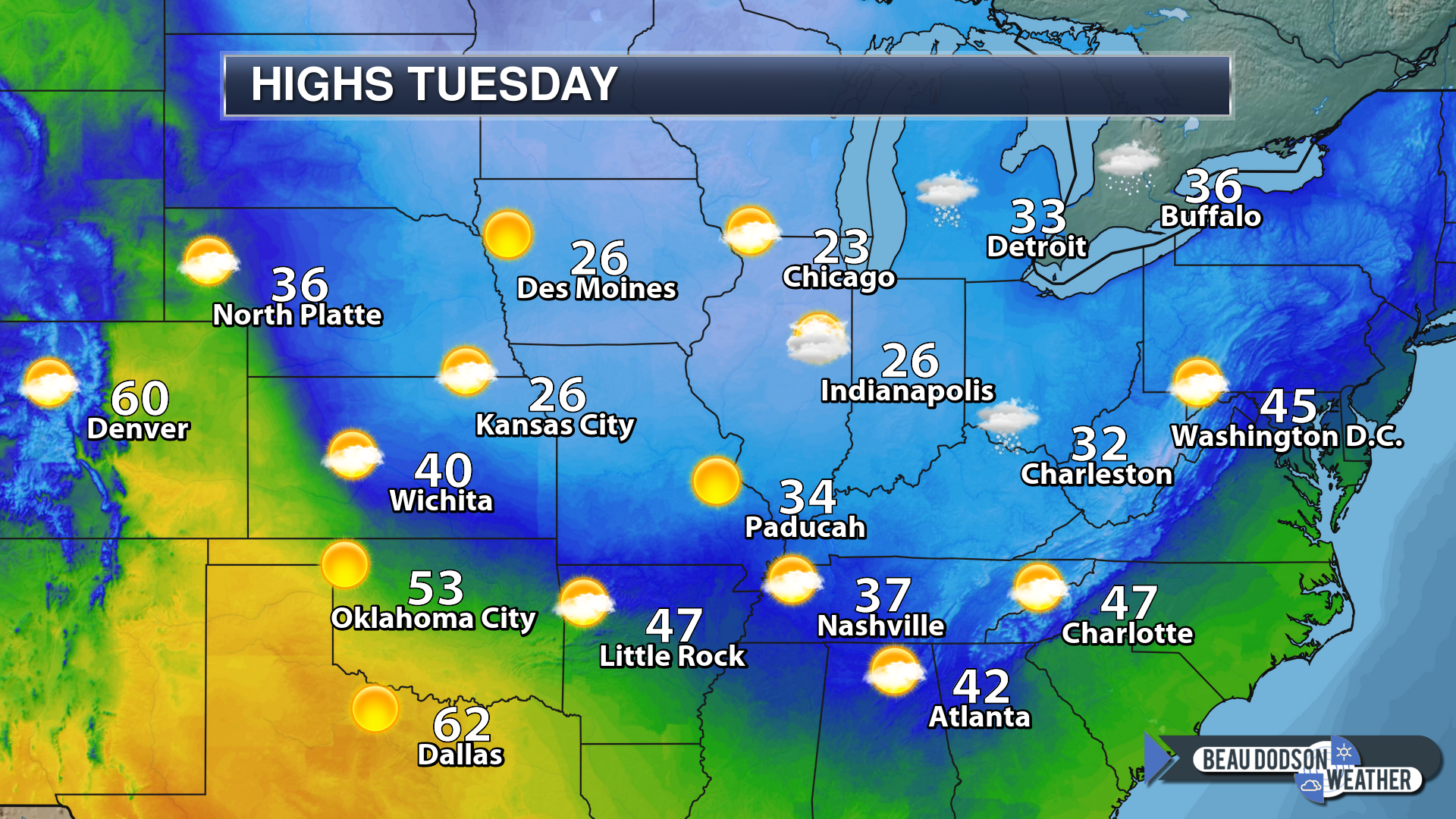
Tuesday forecast: Mostly sunny to partly cloudy.
My confidence in the forecast verifying: Medium (50% confidence)
Temperature range: MO ~ 43 to 46 IL ~43 to 46 KY ~ 44 to 48 TN ~ 44 to 48
Wind chill (feels like) temperature forecast: 38 to 44
What is the chance/probability of precipitation? MO ~ 0% IL ~ 0% KY ~ 0% TN ~ 0%
Coverage of precipitation: None
Is flooding anticipated? No
Is accumulating snow or ice anticipated? No
Is non-accumulating snow or ice anticipated? No
Are icy road conditions anticipated? No
Wind direction and speed:
What impacts are anticipated from the weather? None
Is severe weather expected? No
The NWS officially defines severe weather as 58 mph wind or great, 1″ hail or larger, and/or tornadoes
Will lightning be possible? No
Should I cancel my outdoor plans? No
Will the weather impact my outdoor plans? No
UV Index: 3 Moderate
Sunrise: 6:53 AM
Tuesday Night Forecast Details:
Forecast: Mostly clear and cool.
My confidence in the forecast verifying: Medium (50% confidence)
Temperature range: MO ~ 30 to 35 IL ~ 30 to 35 KY ~ 30 to 35 TN ~ 32 to 36
Wind chill (feels like) temperature forecast: 25 to 30
What is the chance/probability of precipitation? MO ~ 0% IL ~ 0% KY ~ 0% TN ~ 0%
Coverage of precipitation: None
Is flooding anticipated? No
Is accumulating snow or ice anticipated? No
Is non-accumulating snow or ice anticipated? No
Are icy road conditions anticipated? No
Wind direction and speed:
What impacts are anticipated from the weather? None
Is severe weather expected? No
The NWS officially defines severe weather as 58 mph wind or great, 1″ hail or larger, and/or tornadoes
Will lightning be possible? No
Should I cancel my outdoor plans? No
Will the weather impact my outdoor plans? No
Sunset: 4:37 PM
Moonrise: 4:00 AM Waning Crescent
Moonset: 3:17 PM
Learn more about the UV index readings. Click here.
Wind forecast
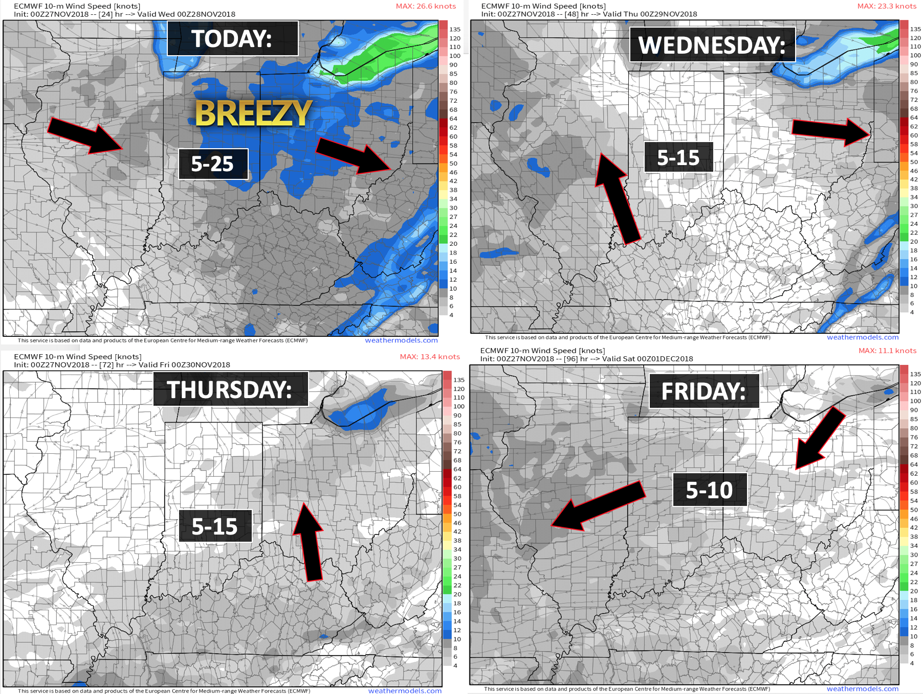

Today through next Saturday: I am not anticipating any accumulating snow through Saturday.
The Weather Observatory will be holding two open houses for adults and children. Weather permitting, the open house will be Saturday, December 1st.
Class of 1988 (Massac County High School). I will be having a special open house for you on Friday, November 30th (the night before the other open house)


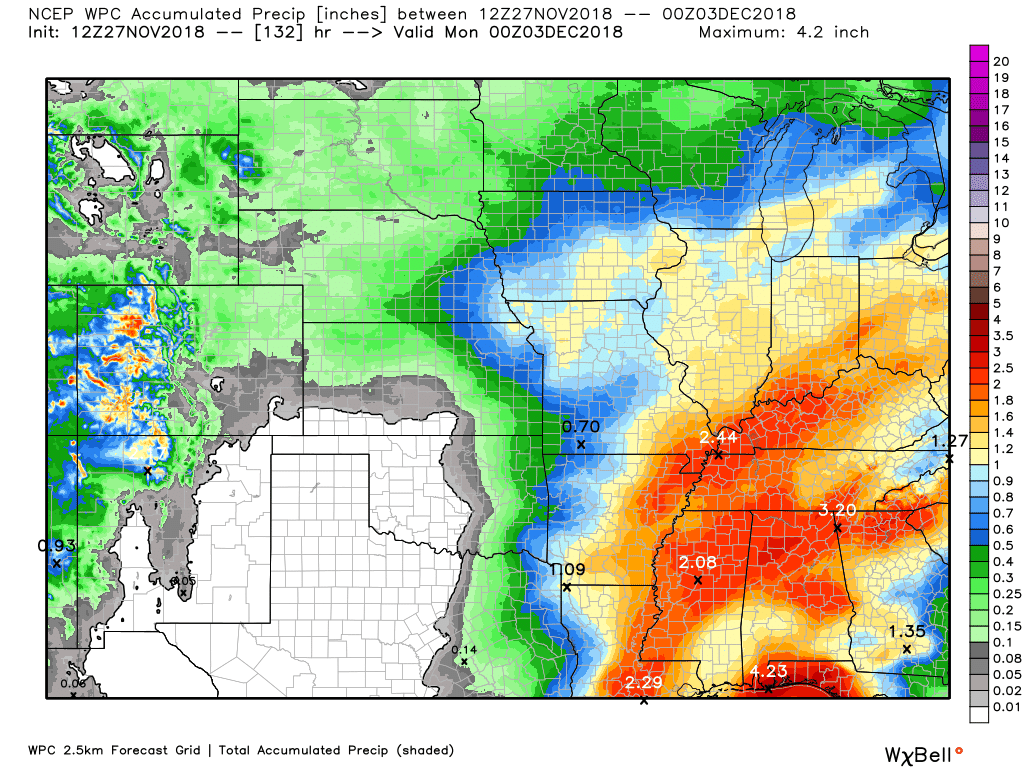
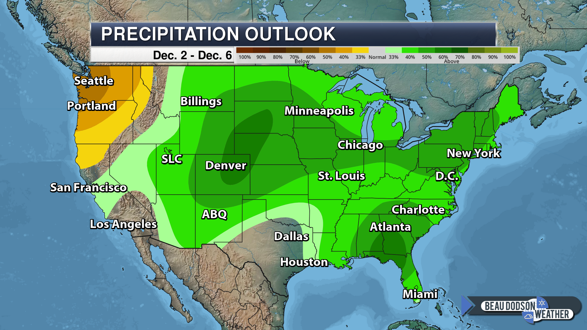
Here is the WPC/NOAA rainfall outlook
A light rain event is possible Thursday into Friday morning. Rain totals will be less than 0.20″.
A stronger system is forecast to arrive Friday night into Saturday. This system could bring some heavy downpours.
Here is the latest WPC rainfall forecast through Sunday afternoon.
A widespread one to two-inch rain event appears possible.
Click image to enlarge.
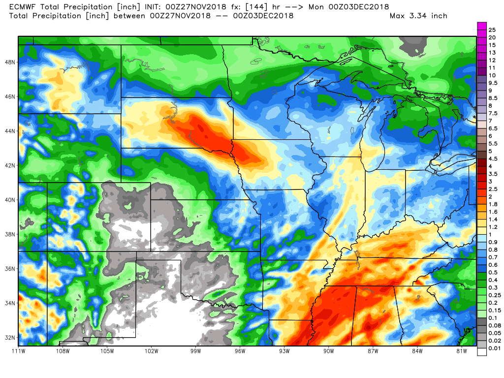
Here is the EC guidance. This shows you what that model is predicting for rain totals.
Did you know that you can find me on Twitter?

Subscribers, do you need a forecast for an outdoor event?


We offer interactive local city live radars and regional radars.
If a radar does not update then try another one. If a radar does not appear to be refreshing then hit Ctrl F5 on your keyboard.
You may also try restarting your browser. The local city view radars also have clickable warnings.
During the winter months, you can track snow and ice by clicking the winterize button on the local city view interactive radars.

Questions? Broken links? Other questions?
You may email me at beaudodson@usawx.com

The National Weather Service defines a severe thunderstorm as one that produces quarter size hail or larger, 58 mph winds or greater, and/or a tornado.
Today through Friday afternoon: No severe thunderstorms.
Friday night through Saturday night: Monitor updates. An incoming storm system could bring thunderstorms to the region. I can’t rule out strong thunderstorms, but it is a bit early for certainties. The greater risk of severe weather may remain to our south.
Interactive live weather radar page. Choose the city nearest your location. If one of the cities does not work then try a nearby one. Click here.
National map of weather watches and warnings. Click here.
Storm Prediction Center. Click here.
Weather Prediction Center. Click here.

Live lightning data: Click here.

Interactive GOES R satellite. Track clouds. Click here.

Here are the latest local river stage forecast numbers Click Here.
Here are the latest lake stage forecast numbers for Kentucky Lake and Lake Barkley Click Here.

- Another cold day on tap for the region with well below normal temperatures.
- A light shower possible Thursday into Friday morning (centered on Thursday night).
- A heavier rain event likely Friday night into Saturday.
The main weather story today will once again be the cold temperatures. What a month this has been. Check out the national temperature anomaly map. This gives you a good idea as to just how cold it has been.
We promised you a colder than normal November. That has been delivered.
Those blues and greens are well below normal temperatures.
Check out Alaska. Normally, when it is warmer than normal in Alaska it is colder than normal here in the Ohio Valley.
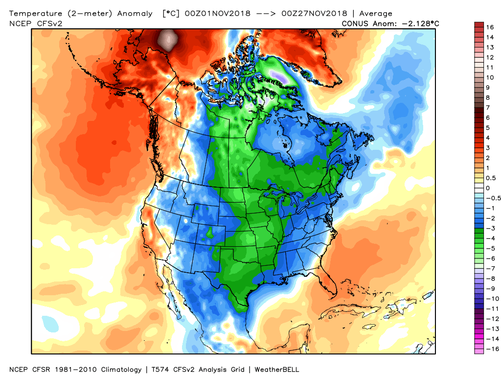
Temperatures today will top out in the 30’s area-wide. Normal highs are in the lower 50’s. Another November day in the books as colder than normal.
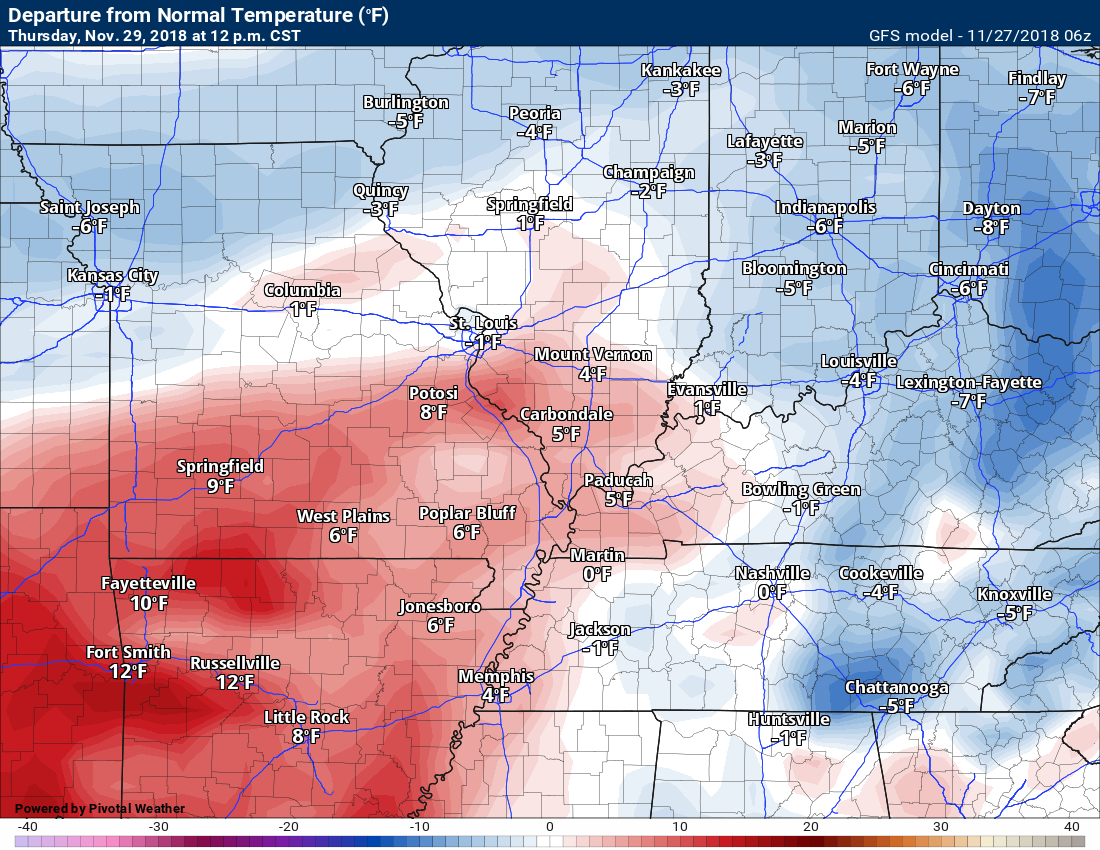
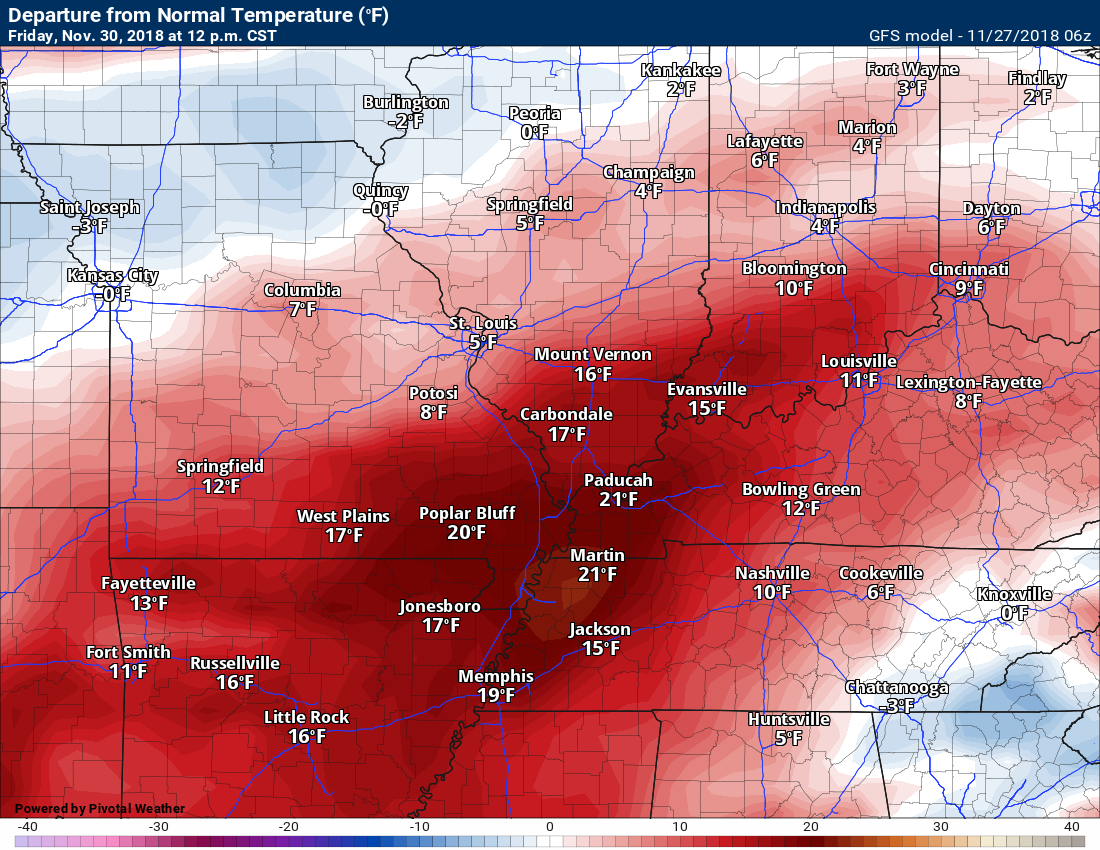
Changes are on the way. We will actually experience above normal temperatures by Thursday and Friday. Collective cheer?
Here are today’s temperature anomalies. These are the anomalies at 12 PM today

Wednesday 12 PM
Thursday 12 PM
Friday 12 PM
Here is the GFS temperature forecast over the coming days.
It shows some warm temperatures Friday and Saturday. Not sure we reach temperatures this high, but certainly 60’s are possible.
Click to enlarge.
Time-stamp upper left part of the animation.
The warm air surges northward ahead of the cold front. That is also one reason we will have widespread showers and thunderstorms Friday into Saturday.

The warm weather will come with a price. Rain chances.
Above normal rainfall is likely over the coming seven days.
Our first chance of rain arrives late Wednesday night into Thursday. A fast moving weak system should bring an increase in clouds and a small chance of rain showers. Many areas may remain dry.
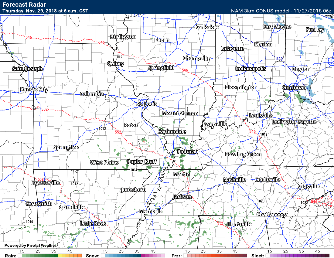
Here is the high-resolution NAM guidance. You can barely see the rain showers showing up Wednesday night and Thursday.
This is showing you 6 AM Thursday future-cast radar. A few light showers.
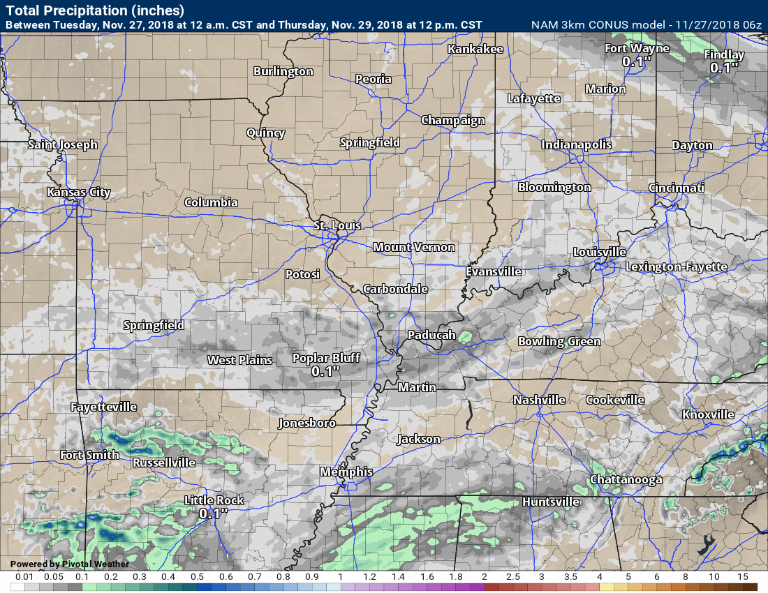
Rain totals through 12 PM Thursday. A scattering of light totals.
Scattered showers are possible Friday, as well.
A larger rain system is forecast to arrive Friday afternoon into Saturday morning. The system has been trending faster. That could mean rain ending Saturday morning. I know many of you have events planned Saturday.
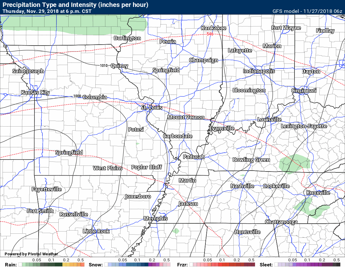
Here is the GFS future-cast radar. Green is rain.
GFS shows widespread rain Friday night into Saturday.
Here is the EC model guidance for Sunday night into Monday morning.
The EC brings the rain into our area earlier than the GFS guidance. I will be monitoring the timing of the precipitation.

Thunderstorms will be possible with this system. Locally moderate to heavy rain, as well.
For now, the greatest risk of severe weather appears to be to our south. The low is taking a favorable track for severe weather in our region. The missing ingredient may be the higher dew points.
Here is the official Storm Prediction Center severe weather outlook.
You can see they have outlined areas to our south for a severe weather risk.
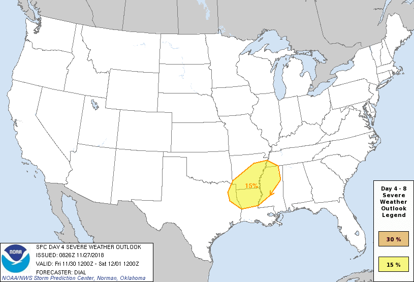
The higher dew points may remain to our south. If so, the threat of severe thunderstorms will be minimal.
Dew points are a measurement of moisture in the lower atmosphere. Higher dew points typically mean an increased risk of severe weather.
It is worth monitoring. It could be that a few severe thunderstorms reach eastern Arkansas and parts of western Tennessee. Let’s keep an eye on it.
Rain totals will likely top an inch across the region. Some areas may reach two inches. This would cause some ditches to fill up and low land flooding. Part of that will depend on if showers and thunderstorms train over the same area. That would enhance rainfall totals.
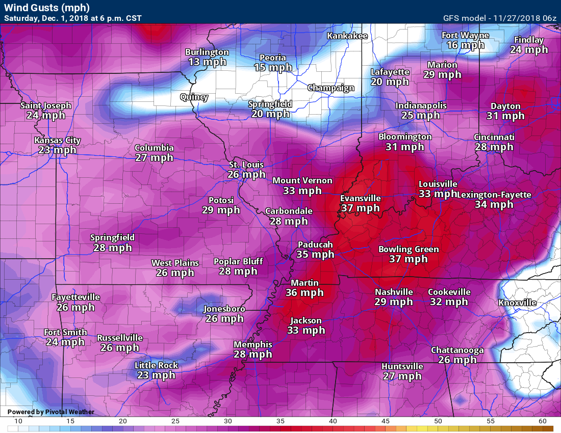
Gusty winds are likely Friday night into Saturday night. Winds will likely top 30 mph.
Wind gust map for Saturday.
The rain should end Saturday afternoon and dry conditions are likely Saturday night into Sunday.
Another system is showing up in the charts by Monday and Monday night.
This is an active pattern.
No major snow events in the cards of our region, yet.
![]()

I bring these to you from the BAMwx team. They are excellent long-range forecasters.
Remember, long-range outlooks are a bit of skill, understanding weather patterns, and luck combined. It is not an exact science.

This product is for subscribers.
Subscribe at www.weathertalk.com
Subscriber graphics can be viewed on this page CLICK HERE

This product is for subscribers.

This product is for subscribers.
Subscribe at www.weathertalk.com
Subscriber graphics can be viewed on this page CLICK HERE
![]()
.
Fall Outlook!
These products are for subscribers.
November temperature and precipitation outlook
November temperature outlook
November precipitation outlook
.These products are for subscribers.
![]()

A new weather podcast is now available! Weather Geeks (which you might remember is on The Weather Channel each Sunday)
To learn more visit their website. Click here.
![]()

WeatherBrains Episode 670
Tonight’s Guest WeatherBrain is the former Meteorologist-in-charge of the National Weather Service in Mount Holly, New Jersey. Gary Szatkowski, welcome to WeatherBrains!
Other discussions in this weekly podcast include topics like:
- The difficulty of precipitation-type winter forecasting
- Snowmageddon-type event in New York similar to Atlanta/Birmingham event of 2014
- Figuring out social media as a meteorologist
- Astronomy Outlook with Tony Rice
- and more!
Link to their website https://weatherbrains.com/
Previous episodes can be viewed by clicking here.

We offer interactive local city live radars and regional radars. If a radar does not update then try another one. If a radar does not appear to be refreshing then hit Ctrl F5. You may also try restarting your browser.
The local city view radars also have clickable warnings.
During the winter months, you can track snow and ice by clicking the winterize button on the local city view interactive radars.
You may email me at beaudodson@usawx.com
Find me on Facebook!

Find me on Twitter!

Did you know that a portion of your monthly subscription helps support local charity projects?
You can learn more about those projects by visiting the Shadow Angel Foundation website and the Beau Dodson News website.

I encourage subscribers to use the app vs regular text messaging. We have found text messaging to be delayed during severe weather. The app typically will receive the messages instantly. I recommend people have three to four methods of receiving their severe weather information.
Remember, my app and text alerts are hand typed and not computer generated. You are being given personal attention during significant weather events.
