We have some great sponsors for the Weather Talk Blog. Please let our sponsors know that you appreciate their support for the Weather Talk Blog.
Milner and Orr Funeral Home and Cremation Services located in Paducah, Kentucky and three other western Kentucky towns – at Milner and Orr they believe in families helping families. You can find Milner and Orr on Facebook, as well.
![]()
.

Wortham Dental Care located in Paducah, Kentucky. The gentle dentist. Mercury free dentistry. They also do safe Mercury removal. You can find Wortham Dental Care on Facebook, as well
.

For all of your families eye care needs. Visit their web-site here. Or, you can also visit their Facebook page.
.

Endrizzi’s Storm Shelters – For more information click here. Endrizzi Contracting and Landscaping can be found on Facebook, as well – click here
.

Best at Enabling Body Shop Profitability since 1996. Located In Paducah Kentucky and Evansville Indiana; serving all customers in between. They provide Customer Service, along with all the tools necessary for body shops to remain educated and competitive. Click the logo above for their main web-site. You can find McClintock Preferred Finishes on Facebook, as well
.

Duck/goose decoys? Game calls? Optics? We have you covered! Click the logo above or visit Final Flight on Facebook, as well.

This forecast update covers far southern Illinois, far southeast Missouri, and far western Kentucky. See the coverage map on the right side of the blog.
Remember that weather evolves. Check back frequently for updates, especially during active weather.
WEATHER RADAR PAGE – Click here —
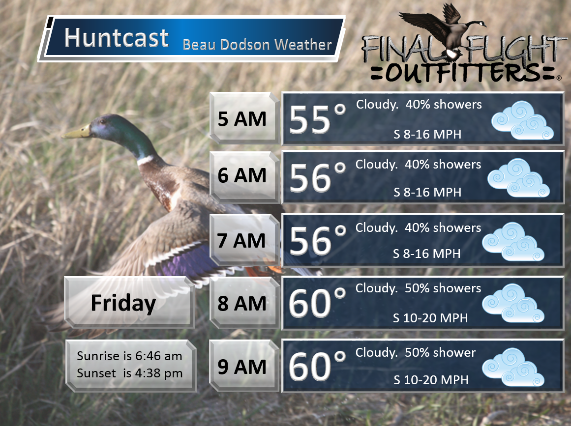
Thursday night – Cloudy with rain developing as the night wears on. Better chances the later into the night you go (eastern counties may have to wait until Friday for their precipitation).
Temperatures: Lows ranging from 50 to 55 degrees.
Winds: South winds at 10 mph
What is the chance for precipitation? 40%
Coverage of precipitation? Scattered
My confidence in this part of the forecast verifying is medium
Should I be concerned about snow or ice? No
Should I cancel my outdoor plans? No, but a shower is possible.
Is severe weather expected? No
What impact is expected? Wet roadways
Friday – Cloudy. Rain developing from northwest to southeast. The rain has slowed a bit from previous forecasts. The rain has slowed by 6-12 hours. It now appears that part of Friday may remain semi-dry. Scattered showers. The main rain shield may wait until late morning into the evening hours for southern Illinois and western Kentucky. Southeast Missouri and southwest Illinois the rain will arrive sooner. Scattered showers are possible at any given time on Friday. The widespread rain, however, may take a bit longer to arrive.
Temperatures: Highs in the upper 50s to lower 60s and then falling into the 40s over parts of southeast Missouri and southwest Illinois towards evening. Lower confidence on the timing of the temperature falling.
Winds: South/southwest winds at 10-20 mph. Winds becoming west/northwest behind the cold front over southeast Missouri and southwest Illinois. Late in the day or towards evening. The wind change will depend on the front passing through. Slow front. Will take awhile.
What is the chance for precipitation? 40%-60%
Coverage of precipitation? Scattered to becoming widespread as the day wears on. Moving in from the northwest to southeast.
My confidence in this part of the forecast verifying is Medium confidence on the rain and low confidence on the temperature
Should I be concerned about snow or ice? No
Should I cancel my outdoor plans? Better monitor updates. Rain appears likely.
Is severe weather expected? No
What impact is expected? Wet roadways
Friday night – Cloudy with rain likely. Colder.
Temperatures: Lows in 40s (upper 30s possible over northern parts of southeast Missouri)
Winds: West/southwest winds at 10 mph
What is the chance for precipitation? 80%
Coverage of precipitation? Widespread rain expected
My confidence in this part of the forecast verifying is High
Should I be concerned about snow or ice? No
Should I cancel my outdoor plans? Have a plan B.
Is severe weather expected? No
What impact is expected? Wet roadways and possible some flooding issues in isolated spots.
Saturday – Cloudy. Colder for much of the region. Rain likely.
Temperatures: Highs in the upper 40s to lower 50s. Temperatures will vary over the region. Colder behind the front. That could mean parts of western Kentucky and northwest Tennessee remain in the 50s during the morning hours. Temperatures falling into the 40s over western Kentucky by late morning into the early afternoon hours. Again, temps will vary.
Winds: South/southeast winds at 6-12 mph. Behind the cold front winds will shift out of the west and northwest.
What is the chance for precipitation? 80%-100%
Coverage of precipitation? Widespread
My confidence in this part of the forecast verifying is Medium
Should I be concerned about snow or ice? No
Should I cancel my outdoor plans? Have a plan B
Is severe weather expected? No
What impact is expected? Wet roadways and possible some flooding issues in isolated spots.
Saturday night – Cloudy with rain likely. Cold rain.
Temperatures: Lows in 40s. Upper 30 possible over parts of southeast Missouri and southwest Illinois. Colder northwest vs southeast in our region.
Winds: Southwest winds at 10 mph Behind the cold front winds will shift out of the west and northwest.
What is the chance for precipitation? 80%-100%
Coverage of precipitation? Widespread rain possible
My confidence in this part of the forecast verifying is Medium
Should I be concerned about snow or ice?
Should I cancel my outdoor plans? Perhaps. Rain is likely in the region.
Is severe weather expected? No
What impact is expected? Wet roadways and possible some flooding issues in isolated spots.
Sunday – Cloudy. Rain possible.
Temperatures: Highs in the middle 40s to lower 50s. Colder northwest counties vs southeast.
Winds: South winds over part of western Kentucky ahead of the cold front. Northwest/west winds behind the cold front. Winds of 8-16 mph.
What is the chance for precipitation? 80%-100%
Coverage of precipitation? Scattered to widespread
My confidence in this part of the forecast verifying is Medium
Should I be concerned about snow or ice? No
Should I cancel my outdoor plans? Perhaps be thinking about a plan B. Monitor updates.
Is severe weather expected? No
What impact is expected? Wet roadways. Some area could have high stream and creek levels.
Sunday night – Cloudy with a chance for showers. Showers should be winding down Sunday night. Some data lingers rain into Monday.
Temperatures: Lows in upper 30s to lower 40s
Winds: Southwest winds at 10 mph
What is the chance for precipitation? 60%
Coverage of precipitation? Showers possible
My confidence in this part of the forecast verifying is Medium
Should I be concerned about snow or ice?
Should I cancel my outdoor plans? No, but monitor updates in case the rain is slow to exit.
Is severe weather expected? No
What impact is expected? Wet roadways.
Monday – Cloudy. Rain possible.
Temperatures: Highs in the lower 50s Lower confidence on temperature on Monday. We could end up mostly in the 40s.
Winds: West at 6-12 mph
What is the chance for precipitation? 60%
Coverage of precipitation? Isolated/scattered early
My confidence in this part of the forecast verifying is Medium
Should I be concerned about snow or ice? No
Should I cancel my outdoor plans? Rain possible.
Is severe weather expected? No
What impact is expected? Wet roadways possible.
Click their ad below to visit their web-site or click here reedelec.com


![]()


Don’t forget to check out the Southern Illinois Weather Observatory web-site for weather maps, tower cams, scanner feeds, radars, and much more! Click here

An explanation of what is happening in the atmosphere over the coming days…
Highlights
1. Widespread rain on Friday into Sunday
2. Rainfall total of 1.5″ to 3.5″ (isolated higher)
3. Small flood risk.
4. Much colder behind the front on Saturday and Sunday (wide temperature range over the region)
I hope everyone is having a wonderful holiday weekend!
Short update today. I hit a deer on my way home last night and I am without some of my computer equipment (my computer equipment is in Illinois and I am in Kentucky).
I have slowed the timing of the widespread rain.
Widespread rain develops from west to east on Thursday night and Friday morning. Rain will reach Poplar Bluff first and Hopkinsville, Kentucky last. I suspect much of the area will be experiencing showers by Friday morning.
The widespread rain will be slow to move in. It could actually take most of the day for the rain to move into southeast Illinois and western Kentucky. Keep that in mind. Earlier forecasts had widespread rain over much of the area by Friday morning. Now it appears it will take longer.
Low confidence on the temperature forecast. Once the front move through the area we will see temperatures fall into the 40. But, what time the front passes each county is questionable. Some of the data bring the colder air into far southern Illinois and western Kentucky by Friday evening. Just not sure that happen.
Radar

WEATHER RADAR PAGE – Click here —
Some moderate to occasionally heavy downpours are possible. Widespread heavy downpours aren’t likely. However, widespread totals of 1.5″-3.5″ can be expected with this system. It will be spread over a 3 day period. Thus, flooding concerns are fairly limited. Some streams and rivers are already high. Obviously these will be the areas of most concern.
Officially there is a flash flood watch for parts of the area. See the watch/warning map below. However, the NWS has stated that they believe the risk is small. Since it is a busy travel weekend they felt it would be best to issue a watch. But, the overall flood risk is limited. If flooding were to occur then Friday night and Saturday would likely be the time-frame.
Click image below for watch or warning information

Thunderstorm risk appears very small with this system. Some rumbles of thunder possible. No severe weather. The lack of thunderstorms i good news. Storms would have greatly enhanced rainfall total (in short periods of time).
Colder air arrives behind the cold front late Friday night into Saturday. Parts of the region will experience temperature in the 50s on Saturday. But, behind the cold front we can expect 40s. I expect part of western Kentucky and Tennessee to remain in the 50s on Saturday. I expect parts of southeast Missouri and southern Illinois will dip into the 40s on Saturday.
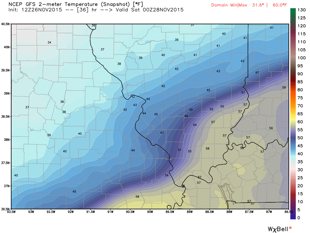
Check out these GFS map for temperatures. Can you find the front?
This first image I will pull out and show you the Central United States
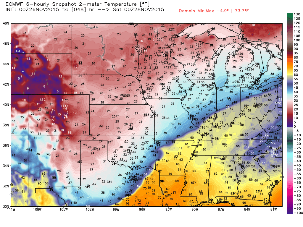
This first map is for Friday morning at 6 am. Temperature in the 30s northwest of St Louis. Temperatures near 60 degrees over southwest Illinois. Sharp front.
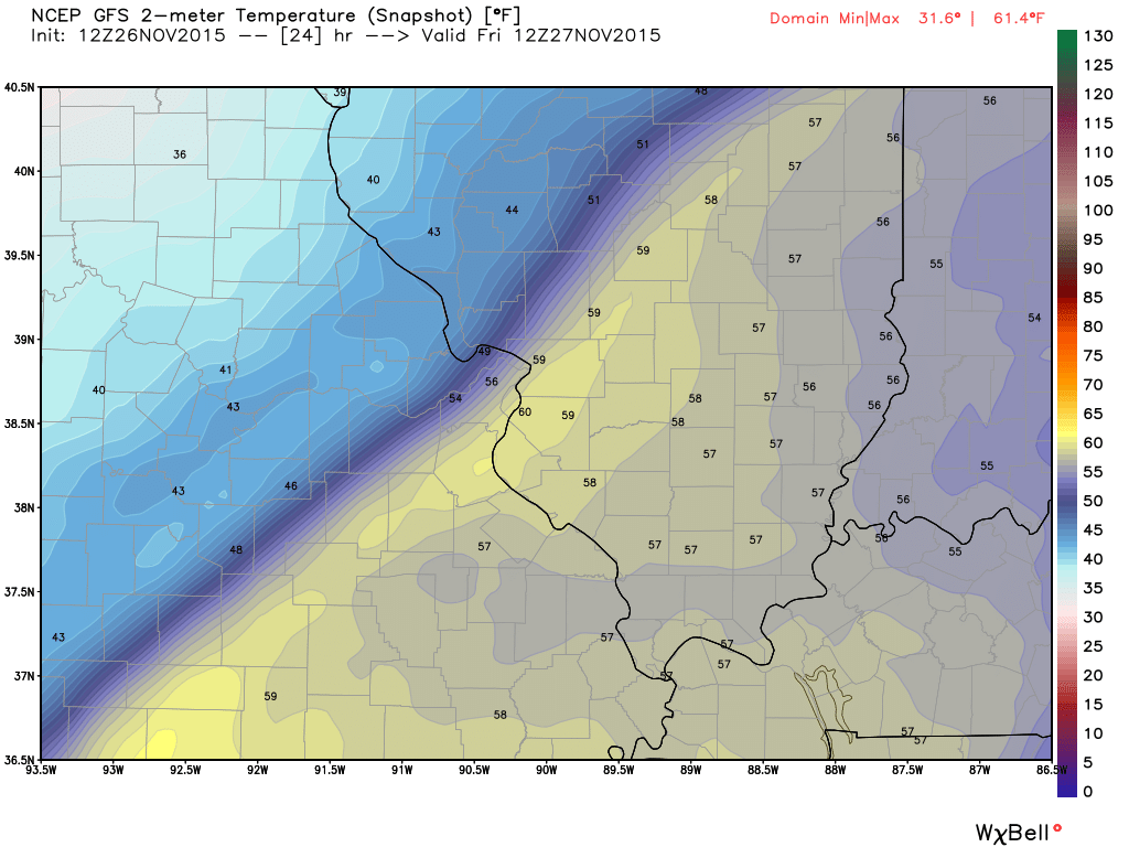
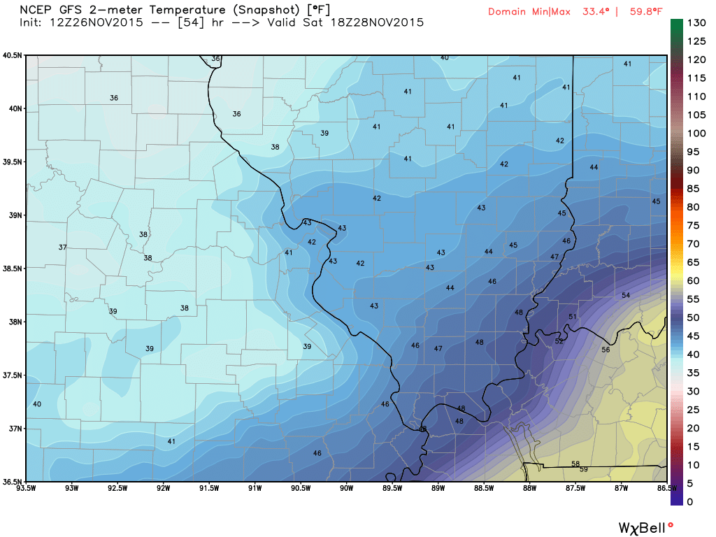
Moving ahead to Friday evening. Forties into southwest Illinois. Near 60 over southeast Illinois.
This next image is for Saturday around 11 am – 1 pm. Brrr. Cold temperature with rain.
I am not expecting snow or ice from this particular system.
Here is where you can expect some ice This is through Friday. Some data pushes it a bit further south and east on Friday and Friday night/Saturday. Not into our local area.
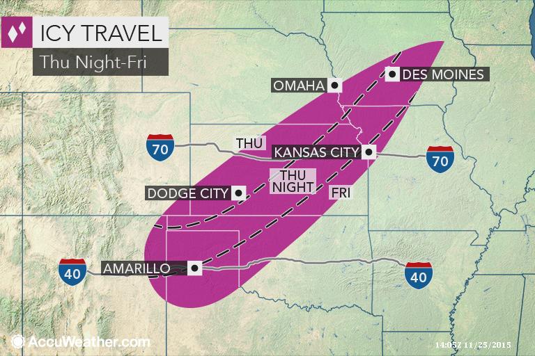

No snow anticipated.

No frozen precipitation through Friday.

Struggling with the timing of the rain arriving. Also a tricky temperature forecast. I did my best to explain all of that above.

Small risk for flooding. Widespread 1.5 to 3.5″ of rain will fall with this system.

Umbrellas! Avoid flooded roadways.

The wild card will be temperatures on Saturday and Sunday. How far south and east will the cold front dip.

No frost in the forecast.

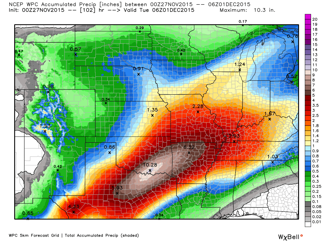
How much precipitation should we expect over the next few days?
A widespread 1.5-3.5″ rainfall event for the region. This will be spread out over a three day period. Click image for a larger view.
Look at those total in Oklahoma and Arkansas. Another very large rain event for that area, as well.

Can we expect severe thunderstorms over the next 24 to 48 hours? Remember that a severe thunderstorm is defined as a thunderstorm that produces 58 mph winds or higher, quarter size hail or larger, and/or a tornado.
The thunderstorm threat level will be ONE for Thursday night into Saturday. Small chance for a rumble of thunder.
.
Thursday: Severe weather is not anticipated. Thunder Thursday night?
Friday: Severe weather is not anticipated. Thunder?
Saturday: Severe weather is not anticipated.
Sunday: Severe weather is not anticipated.
Monday: Severe weather is not anticipated.
Tuesday: Severe weather is not anticipated.

Here is the official 6-10 day and 8-14 day temperature and precipitation outlook. Check the date stamp at the top of each image (so you understand the time frame).
The forecast maps below are issued by the Weather Prediction Center (NOAA).


The latest 8-14 day temperature and precipitation outlook. Note the dates are at the top of the image. These maps DO NOT tell you how high or low temperatures or precipitation will be. They simply give you the probability as to whether temperatures or precipitation will be above or below normal.


Here are the current river stage forecasts. You can click your state and then the dot for your location. It will bring up the full forecast and hydrograph.
Click Here For River Stage Forecasts…

Who do you trust for your weather information and who holds them accountable?
I have studied weather in our region since the late 1970’s. I have 37 years of experience in observing our regions weather patterns. My degree is in Broadcast Meteorology from Mississippi State University and an Associate of Science (AS). I am currently working on my Bachelor’s Degree in Geoscience.
My resume includes:
Member of the American Meteorological Society.
NOAA Weather-Ready Nation Ambassador.
Meteorologist for McCracken County Emergency Management.
I own and operate the Southern Illinois Weather Observatory.
Recipient of the Mark Trail Award, WPSD Six Who Make A Difference Award, Kentucky Colonel, and the Caesar J. Fiamma” Award from the American Red Cross.
In 2009 I was presented with the Kentucky Office of Highway Safety Award.
Recognized by the Kentucky House of Representatives for my service to the State of Kentucky leading up to several winter storms and severe weather outbreaks.
I am also President of the Shadow Angel Foundation which serves portions of western Kentucky and southern Illinois.
There is a lot of noise on the internet. A lot of weather maps are posted without explanation. Over time you should learn who to trust for your weather information.
My forecast philosophy is simple and straight forward.
- Communicate in simple terms
- To be as accurate as possible within a reasonable time frame before an event
- Interact with you on Twitter, Facebook, and the blog
- Minimize the “hype” that you might see on television or through other weather sources
- Push you towards utilizing wall-to-wall LOCAL TV coverage during severe weather events
I am a recipient of the Mark Trail Award, WPSD Six Who Make A Difference Award, Kentucky Colonel, and the Caesar J. Fiamma” Award from the American Red Cross. In 2009 I was presented with the Kentucky Office of Highway Safety Award. I was recognized by the Kentucky House of Representatives for my service to the State of Kentucky leading up to several winter storms and severe weather outbreaks.
If you click on the image below you can read the Kentucky House of Representatives Resolution.

Many of my graphics are from www.weatherbell.com – a great resource for weather data, model data, and more


You can sign up for my AWARE email by clicking here I typically send out AWARE emails before severe weather, winter storms, or other active weather situations. I do not email watches or warnings. The emails are a basic “heads up” concerning incoming weather conditions.