
WeatherTalk monthly operating costs can top $2000.00. Your $5 subscription helps pay for those costs. I work for you.
The $5 will allow you to register up to seven phones!
For $5 a month you can receive the following. You may choose to receive these via your WeatherTalk app or regular text messaging.
Severe weather app/text alerts from my keyboard to your app/cell phone. These are hand typed messages from me to you. During tornado outbreaks, you will receive numerous app/text messages telling you exactly where the tornado is located.
- Daily forecast app/texts from my computer to your app/cell phone.
- Social media links sent directly to your app/cell phone. When I update the blog, videos, or Facebook you will receive the link.
- AWARE emails. These emails keep you well ahead of the storm. They give you several days of lead time before significant weather events.
- Direct access to Beau via text and email. Your very own personal meteorologist. I work for you!
- Missouri and Ohio Valley centered video updates
- Long-range weather videos
- Week one, two, three and four temperature and precipitation outlooks.
Monthly outlooks. - Your subscription also will help support several local charities.
Would you like to subscribe? Subscribe at www.beaudodsonweather.com
Typical progression on a severe weather day for subscribers.


I encourage subscribers to use the app vs regular text messaging. We have found text messaging to be delayed during severe weather. The app typically will receive the messages instantly. I recommend people have three to four methods of receiving their severe weather information.
Remember, my app and text alerts are hand typed and not computer generated. You are being given my personal attention during significant weather events.

WWW.WEATHERTALK.COM subscribers, here is my day to day schedule for your weather products.
These are bonus videos and maps for subscribers. I bring these to you from the BAMwx team. I pay them to help with videos.
The Ohio and Missouri Valley videos cover most of our area. They do not have a specific Tennessee Valley forecast but may add one in the future.
The long-range video is technical. Over time, you can learn a lot about meteorology from the long range video. Just keep in mind, it is a bit more technical.


Subscribe at www.weathertalk.com
![]()

November 23, 2018
Friday forecast: Thickening clouds. Breezy conditions developing. Rain will spread west to east over southeast Missouri during the morning and early afternoon hours. Rain will then continue to spread across the region of the region. Cold/chilly rain.
Temperatures: MO ~ 52 to 56 IL ~ 53 to 56 KY ~ 54 to 58 TN ~ 54 to 58
What is the chance of precipitation? MO ~ 70% IL ~ 60% KY ~ 60% TN ~ 60%
Coverage of precipitation: Becoming widespread as the day wears on
Is snow or ice anticipated? No
Wind: South and southeast at 15 to 30 mph. Gusty.
What impacts are anticipated from the weather? Wet roadways. Strong and gusty winds.
My confidence in the forecast verifying: High (70% confidence)
Is severe weather expected? No
The NWS defines severe weather as 58 mph wind or great, 1″ hail or larger, and/or tornadoes
Should I cancel my outdoor plans? No
UV Index: 1 to 2 Low
Sunrise: 6:41 AM
Friday Night Forecast Details:
Forecast: Cloudy. Rain showers. Rain tapering west to east as we move through the night. Wet earlier vs later. Chilly.
Temperatures: MO ~ 43 to 46 IL ~ 43 to 46 KY ~ 43 to 46 TN ~ 44 to 46
What is the chance of precipitation? MO ~ 70% IL ~ 70% KY ~ 70% TN ~ 70%
Coverage of precipitation: Widespread
Is snow or ice anticipated? No
Wind: Southeast to south at 8 to 16 mph with gusts to 25 mph. Gusty.
What impacts are anticipated from the weather? Wet roadways.
My confidence in the forecast verifying: High (80% confidence)
Is severe weather expected? No
The NWS defines severe weather as 58 mph wind or great, 1″ hail or larger, and/or tornadoes
Should I cancel my outdoor plans? Have a plan B. Rain likely.
Sunset: 4:40 PM
Moonrise: 5:27 PM Waning Gibbous
Moonset: 6:55 AM
November 24, 2018
Saturday forecast: Intervals of clouds. Cool temperatures. Temperatures will be dependent on cloud cover. If clouds are thicker then temperatures will be lower.
Temperatures: MO ~ 58 to 64 IL ~ 58 to 64 KY ~ 58 to 64 TN ~ 60 to 64
What is the chance of precipitation? MO ~ 0% IL ~ 0% KY ~ 0% TN ~ 0%
Coverage of precipitation: None
Is snow or ice anticipated? No
Wind: Becoming southwest at 6 to 12 mph with gusts to 20 mph
What impacts are anticipated from the weather? None
My confidence in the forecast verifying: High (70% confidence)
Is severe weather expected? No
The NWS defines severe weather as 58 mph wind or great, 1″ hail or larger, and/or tornadoes
Should I cancel my outdoor plans? No
UV Index: 3 to 4 Medium
Sunrise: 6:44 AM
Saturday Night Forecast Details:
Forecast: Mostly clear early. Some increase in clouds overnight. Cool temperatures. We should remain dry. There is a small chance of a light shower after 3 AM across our western counties of southeast Missouri.
Temperatures: MO ~ 42 to 46 IL ~ 42 to 46 KY ~ 42 to 46 TN ~ 42 to 46
What is the chance of precipitation? MO ~ 10% late IL ~ 10% KY ~ 0% TN ~ 0%
Coverage of precipitation: Most likely none.
Is snow or ice anticipated? No
Wind: South at 7 to 14 mph with gusts to 20 mph
What impacts are anticipated from the weather? None
My confidence in the forecast verifying: Medium (60% confidence)
Is severe weather expected? No
The NWS defines severe weather as 58 mph wind or great, 1″ hail or larger, and/or tornadoes
Should I cancel my outdoor plans? No
Sunset: 4:39 PM
Moonrise: 6:17 PM Waning Gibbous
Moonset: 8:02 AM
November 25, 2018
Sunday forecast: Intervals of clouds. Becoming windy. We will have showers developing. Some areas may remain completely dry. The system is a bit moisture starved over our region. Rain totals will be on the light side. Less than 0.25″ is anticipated. Warmer ahead of the incoming cold front on southerly winds. Parts of western Kentucky and Tennessee could even approach the 70 degree mark.
Temperatures: MO ~ 55 to 60 IL ~ 58 to 64 KY ~ 64 to 70 TN ~ 65 to 70
What is the chance of precipitation? MO ~ 40% IL ~ 40% KY ~ 30% TN ~ 30%
Coverage of precipitation: Scattered
Is snow or ice anticipated? No
Wind: South and southeast winds becoming southwest and west as the front moves across the region. Strong and gusty winds likely. Wind speeds of 10 to 20 mph with gusts above 40 mph.
What impacts are anticipated from the weather? Wet roadways. Windy conditions.
My confidence in the forecast verifying: Medium (60% confidence)
Is severe weather expected? No
The NWS defines severe weather as 58 mph wind or great, 1″ hail or larger, and/or tornadoes
Should I cancel my outdoor plans? Monitor updates. Some rain will be possible.
UV Index: 1 to 2 Low
Sunrise: 6:45 AM
Sunday Night Forecast Details:
Forecast: Mostly cloudy. A few rain showers early in the night. Windy. Rain may end as non-accumulating snow. Turning colder. The best chance of snow flurries or snow showers will stretch from Cape Girardeau, Missouri, to Harrisburg, Illinois and then northeast of there. At this time it appears snow will not accumulate.
Temperatures: MO ~ 26 to 30 IL ~ 26 to 30 KY ~ 26 to 30 TN ~ 28 to 34
What is the chance of precipitation? MO ~ 40% to 50% IL ~ 50% KY ~ 40% TN ~ 40%
Coverage of precipitation: Ending early in the night.
Is snow or ice anticipated? Flurries or a snow shower possible. No accumulation anticipated.
Wind: West and northwest at 10 to 20 mph with gusts above 35 mph
What impacts are anticipated from the weather? Wet roadways. Falling temperatures behind the area of low pressure could turn the rain to flurries or snow showers.
My confidence in the forecast verifying: Medium (50% confidence)
Is severe weather expected? No
The NWS defines severe weather as 58 mph wind or great, 1″ hail or larger, and/or tornadoes
Should I cancel my outdoor plans? Monitor updates. Some rain will be possible.
Sunset: 4:39 PM
Moonrise: 7:14 PM Waning Gibbous
Moonset: 9:08 AM
November 26, 2018
Monday forecast: Partly sunny. Windy. Colder with well below normal temperatures. January like temperatures. Normal highs in January are in the middle 40’s.
Temperatures: MO ~ 35 to 40 IL ~ 36 to 40 KY ~ 38 to 44 TN ~ 38 to 44
What is the chance of precipitation? MO ~ 0% IL ~ 10% KY ~ 10% TN ~ 0%
Coverage of precipitation: Most likely none
Is snow or ice anticipated? No
Wind: Northwest winds at 10 to 20 mph with higher gusts.
What impacts are anticipated from the weather? None
My confidence in the forecast verifying: High (70% confidence)
Is severe weather expected? No
The NWS defines severe weather as 58 mph wind or great, 1″ hail or larger, and/or tornadoes
Should I cancel my outdoor plans? No
UV Index: 3 to 4 Low to medium
Sunrise: 6:46 AM
Monday Night Forecast Details:
Forecast: Mostly clear. Colder with well below normal temperatures.
Temperatures: MO ~ 23 to 26 IL ~ 23 to 26 KY ~ 24 to 28 TN ~ 24 to 28
What is the chance of precipitation? MO ~ 0% IL ~ 10% KY ~ 10% TN ~ 0%
Coverage of precipitation: None
Is snow or ice anticipated? No
Wind: West and northwest at 5 to 10 mph
What impacts are anticipated from the weather? None
My confidence in the forecast verifying: Medium (60% confidence)
Is severe weather expected? No
The NWS defines severe weather as 58 mph wind or great, 1″ hail or larger, and/or tornadoes
Should I cancel my outdoor plans? No
Sunset: 4:38 PM
Moonrise: 8:17 PM Waning Gibbous
Moonset: 10:08 AM
Dry weather is expected Tuesday and Wednesday, as well.

Today through next Wednesday: No significant winter weather anticipated. A snow flurry or snow shower possible late Sunday night as colder air arrives before the storm system. No accumulation.
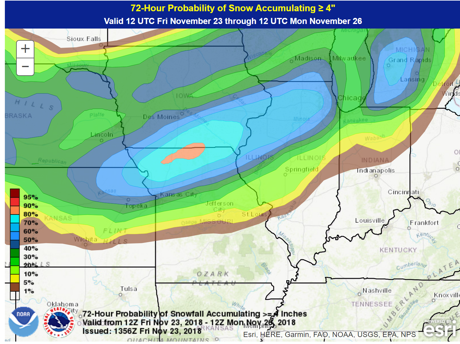
A blizzard is forecast to impact portions of Iowa, northern Missouri, Wisconsin, and northern Illinois. If you have travel plans in those areas then monitor winter storm warnings and road conditions.
What is the chance of four or more inches of snow Saturday into Sunday night?
If you have travel plans in these areas then monitor road conditions.
The Weather Observatory will be holding two open houses for adults and children. Weather permitting, the open house will be Saturday, December 1st.
Class of 1988 (Massac County High School). I will be having a special open house for you on Friday, November 30th (the night before the other open house)

Learn more about the UV index readings. Click here.

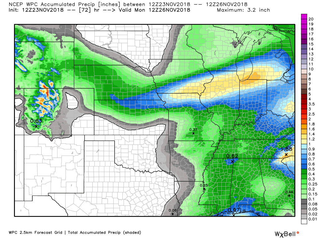
Here is the WPC/NOAA rainfall outlook
Two rain events. One today and tonight and another Sunday/Sunday night.
These are light rain events. Some areas may receive no rain during the Sunday event.
Most areas will receive 0.25″ to 0.50″.
Did you know that you can find me on Twitter?

Subscribers, do you need a forecast for an outdoor event?


We offer interactive local city live radars and regional radars.
If a radar does not update then try another one. If a radar does not appear to be refreshing then hit Ctrl F5 on your keyboard.
You may also try restarting your browser. The local city view radars also have clickable warnings.
During the winter months, you can track snow and ice by clicking the winterize button on the local city view interactive radars.

Questions? Broken links? Other questions?
You may email me at beaudodson@usawx.com

The National Weather Service defines a severe thunderstorm as one that produces quarter size hail or larger, 58 mph winds or greater, and/or a tornado.
Today through Wednesday: No severe thunderstorms.
Interactive live weather radar page. Choose the city nearest your location. If one of the cities does not work then try a nearby one. Click here.
National map of weather watches and warnings. Click here.
Storm Prediction Center. Click here.
Weather Prediction Center. Click here.

Live lightning data: Click here.

Interactive GOES R satellite. Track clouds. Click here.

Here are the latest local river stage forecast numbers Click Here.
Here are the latest lake stage forecast numbers for Kentucky Lake and Lake Barkley Click Here.

- I hope everyone is having a nice holiday weekend
- Rain chances ramp up today
- Windy weekend ahead
- Additional rain chances Sunday/Sunday night
- Much colder Sunday night into early next week
- A few snow showers Sunday night
Good day, everyone!
I hope you and your family are well and having a great weekend. It has been a cool one. Not as cold as some of the days over recent weeks, but still cooler than normal.
We have two systems to track over the next 72 hours.
The first one is already arriving in the region. Radar shows a few showers forming over southeast Missouri. This will spread east through the day. Rain won’t be heavy and no severe weather anticipated.
See the local-city view interactive weather radars to track the rain.
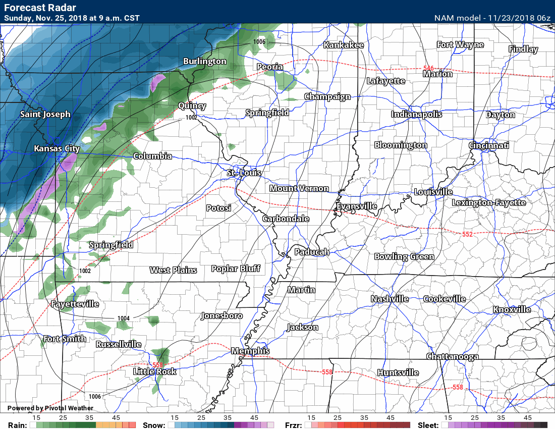
Here is the future-cast radar from the Hrrr guidance. This is a model. It won’t be exact but you do get a general idea.
Rain chances peak this afternoon and tonight.
Time-stamp upper left. Click images on this page to enlarge them.

No snow or ice with this event, either.
Rain totals will range from 0.10″ to 0.30″. The bulk of the rain will arrive this afternoon and tonight.
Windy conditions will also develop today with winds in the 15 to 30 mph range developing this afternoon and tonight. Winds will generally be from the south and southwest.
Rain will end tonight and Saturday should be dry.
The dry spell won’t last long.
The next chance of rain arrives Sunday and Sunday night. At one time, this appeared to be a larger rain event. Over time, however, it has become clear that this will be a scattered rain event. Some areas will remain dry. Keep that in mind.
A powerful winter storm will strike to our north.
The heaviest snow will likely fall across parts of Iowa, northern Missouri, Wisconsin, and northern Illinois. Snow totals in excess of 6 inches are going to occur. High winds will create blizzard conditions.
Thankfully, this will remain out of our region.
Blue is snow. Heavy snow in the case. See those tight black lines? Those are isobars. An isobar is an equal line of pressure.
Tightly packed isobars represent high winds.
I can’t rule out the rain ending as a few snowflakes Sunday night. This would most likely be across northern parts of southeast Missouri and northern parts of southern Illinois. No accumulation anticipated.
Temperatures will fall into the 20’s Sunday night. High winds will likely quickly dry the moisture off of roadways. Thus, at this time, it appears we won’t have any icy road conditions.
Winds Sunday and Sunday night could gust above 40 mph. These are gradient winds. Gradient winds are caused by tight barometric pressure readings. Rapidly rising or falling pressure.
Monday should be dry.
An active storm pattern over the coming weeks with multiple chances of precipitation.
![]()

I bring these to you from the BAMwx team. They are excellent long-range forecasters.
Remember, long-range outlooks are a bit of skill, understanding weather patterns, and luck combined. It is not an exact science.

This product is for subscribers.
Subscribe at www.weathertalk.com
Subscriber graphics can be viewed on this page CLICK HERE

This product is for subscribers.

This product is for subscribers.
Subscribe at www.weathertalk.com
Subscriber graphics can be viewed on this page CLICK HERE
![]()
.
Fall Outlook!
These products are for subscribers.
November temperature and precipitation outlook
November temperature outlook
November precipitation outlook
.These products are for subscribers.
![]()

A new weather podcast is now available! Weather Geeks (which you might remember is on The Weather Channel each Sunday)
To learn more visit their website. Click here.
![]()

WeatherBrains Episode 670
Tonight’s Guest WeatherBrain is the former Meteorologist-in-charge of the National Weather Service in Mount Holly, New Jersey. Gary Szatkowski, welcome to WeatherBrains!
Other discussions in this weekly podcast include topics like:
- The difficulty of precipitation-type winter forecasting
- Snowmageddon-type event in New York similar to Atlanta/Birmingham event of 2014
- Figuring out social media as a meteorologist
- Astronomy Outlook with Tony Rice
- and more!
Link to their website https://weatherbrains.com/
Previous episodes can be viewed by clicking here.

We offer interactive local city live radars and regional radars. If a radar does not update then try another one. If a radar does not appear to be refreshing then hit Ctrl F5. You may also try restarting your browser.
The local city view radars also have clickable warnings.
During the winter months, you can track snow and ice by clicking the winterize button on the local city view interactive radars.
You may email me at beaudodson@usawx.com
Find me on Facebook!

Find me on Twitter!

Did you know that a portion of your monthly subscription helps support local charity projects?
You can learn more about those projects by visiting the Shadow Angel Foundation website and the Beau Dodson News website.

I encourage subscribers to use the app vs regular text messaging. We have found text messaging to be delayed during severe weather. The app typically will receive the messages instantly. I recommend people have three to four methods of receiving their severe weather information.
Remember, my app and text alerts are hand typed and not computer generated. You are being given personal attention during significant weather events.
