
WeatherTalk monthly operating costs can top $2000.00. Your $5 subscription helps pay for those costs. I work for you.
The $5 will allow you to register up to seven phones!
For $5 a month you can receive the following. You may choose to receive these via your WeatherTalk app or regular text messaging.
Severe weather app/text alerts from my keyboard to your app/cell phone. These are hand typed messages from me to you. During tornado outbreaks, you will receive numerous app/text messages telling you exactly where the tornado is located.
- Daily forecast app/texts from my computer to your app/cell phone.
- Social media links sent directly to your app/cell phone. When I update the blog, videos, or Facebook you will receive the link.
- AWARE emails. These emails keep you well ahead of the storm. They give you several days of lead time before significant weather events.
- Direct access to Beau via text and email. Your very own personal meteorologist. I work for you!
- Missouri and Ohio Valley centered video updates
- Long-range weather videos
- Week one, two, three and four temperature and precipitation outlooks.
Monthly outlooks. - Your subscription also will help support several local charities.
Would you like to subscribe? Subscribe at www.beaudodsonweather.com
Typical progression on a severe weather day for subscribers.


I encourage subscribers to use the app vs regular text messaging. We have found text messaging to be delayed during severe weather. The app typically will receive the messages instantly. I recommend people have three to four methods of receiving their severe weather information.
Remember, my app and text alerts are hand typed and not computer generated. You are being given my personal attention during significant weather events.

WWW.WEATHERTALK.COM subscribers, here is my day to day schedule for your weather products.
These are bonus videos and maps for subscribers. I bring these to you from the BAMwx team. I pay them to help with videos.
The Ohio and Missouri Valley videos cover most of our area. They do not have a specific Tennessee Valley forecast but may add one in the future.
The long-range video is technical. Over time, you can learn a lot about meteorology from the long range video. Just keep in mind, it is a bit more technical.


.
![]()

November 20, 2018
Tuesday forecast: Patchy morning fog. A mix of sun and clouds. Clouds are redeveloping to our north and will slide south. Sun may then develop behind those clouds. Well below normal temperatures. Cold.
Temperatures: MO ~ 36 to 44 IL ~ 38 to 44 KY ~ 40 to 45 TN ~ 43 to 46
What is the chance of precipitation? MO ~ 0% IL ~ 0% KY ~ 0% TN ~ 0%
Coverage of precipitation: None
Is snow or ice anticipated? No. Some patchy freezing fog possible across NW TN at sunrise.
Wind: North and northwest at 4 to 8 mph
What impacts are anticipated from the weather? Perhaps some slick spots on bridges where temperatures are colder (NW TN).
My confidence in the forecast verifying: High (70%)
Is severe weather expected? No
The NWS defines severe weather as 58 mph wind or great, 1″ hail or larger, and/or tornadoes
Should I cancel my outdoor plans? No
UV Index: 4 to 5 Moderate
Sunrise: 6:40 AM
Tuesday Night Forecast Details:
Forecast: Mostly clear. Cold. Below normal temperatures to continue. Patchy fog possible.
Temperatures: MO ~ 26 to 28 IL ~ 24 to 28 KY ~ 26 to 30 TN ~ 28 to 34
What is the chance of precipitation? MO ~ 0% IL ~ 0% KY ~ 0% TN ~ 0%
Coverage of precipitation: None
Is snow or ice anticipated? No
Wind: Light wind
What impacts are anticipated from the weather? Lower visibility where fog forms
My confidence in the forecast verifying: High (80%)
Is severe weather expected? No
The NWS defines severe weather as 58 mph wind or great, 1″ hail or larger, and/or tornadoes
Should I cancel my outdoor plans? No
Sunset: 4:41 PM
Moonrise: 3:31 PM Waxing Gibbous
Moonset: 3:39 AM
WINTER UPDATE IN TODAY’S LONG RANGE VIDEO.
November 21, 2018
Wednesday forecast: Patchy morning fog. Mostly sunny. Cool. Below normal temperatures.
Temperatures: MO ~ 52 to 55 IL ~ 50 to 54 KY ~ 52 to 55 TN ~ 52 to 55
What is the chance of precipitation? MO ~ 0% IL ~ 0% KY ~ 0% TN ~ 0%
Coverage of precipitation: None
Is snow or ice anticipated? No
Wind: Light winds less than 10 mph. Becoming southwest at 5 mph
What impacts are anticipated from the weather? None
My confidence in the forecast verifying: High (80%)
Is severe weather expected? No
The NWS defines severe weather as 58 mph wind or great, 1″ hail or larger, and/or tornadoes
Should I cancel my outdoor plans? No
UV Index: 4 to 5 Moderate
Sunrise: 6:41 AM
Wednesday Night Forecast Details:
Forecast: Mostly clear. Cold. Patchy fog.
Temperatures: MO ~ 28 to 34 IL ~ 28 to 34 KY ~ 30 to 35 TN ~ 30 to 35
What is the chance of precipitation? MO ~ 0% IL ~ 0% KY ~ 0% TN ~ 0%
Coverage of precipitation: None
Is snow or ice anticipated? No
Wind: South and southeast at 4 to 8 mph
What impacts are anticipated from the weather? Lower visibility where fog forms
My confidence in the forecast verifying: High (80%)
Is severe weather expected? No
The NWS defines severe weather as 58 mph wind or great, 1″ hail or larger, and/or tornadoes
Should I cancel my outdoor plans? No
Sunset: 4:41 PM
Moonrise: 4:04 PM Waxing Gibbous
Moonset: 4:42 AM
November 22, 2018
Thanksgiving
Thursday forecast: Mostly sunny. A bit milder. Near normal temperatures.
Temperatures: MO ~ 54 to 58 IL ~ 52 to 56 KY ~ 54 to 58 TN ~ 54 to 58
What is the chance of precipitation? MO ~ 0% IL ~ 0% KY ~ 0% TN ~ 0%
Coverage of precipitation: None
Is snow or ice anticipated? No
Wind: East and southeast at 5 to 10 mph
What impacts are anticipated from the weather? None
My confidence in the forecast verifying: High (90%)
Is severe weather expected? No
The NWS defines severe weather as 58 mph wind or great, 1″ hail or larger, and/or tornadoes
Should I cancel my outdoor plans? No
UV Index: 4 to 5 Moderate
Sunrise: 6:42 AM
Thursday Night Forecast Details:
Forecast: Mostly clear. Some late night clouds possible.
Temperatures: MO ~ 36 to 40 IL ~ 36 to 40 KY ~ 36 to 40 TN ~ 36 to 40
What is the chance of precipitation? MO ~ 0% IL ~ 0% KY ~ 0% TN ~ 0%
Coverage of precipitation: None
Is snow or ice anticipated? No
Wind: Southeast at 4 to 8 mph
What impacts are anticipated from the weather? None
My confidence in the forecast verifying: High (70%)
Is severe weather expected? No
The NWS defines severe weather as 58 mph wind or great, 1″ hail or larger, and/or tornadoes
Should I cancel my outdoor plans? No
Sunset: 4:40 PM
Moonrise: 4:43 PM Full
Moonset: 5:48 AM
November 23, 2018
Friday forecast: Becoming cloudy. A chance of showers, especially during the late morning and afternoon. Breezy.
Temperatures: MO ~ 52 to 56 IL ~ 52 to 56 KY ~ 52 to 56 TN ~ 52 to 56
What is the chance of precipitation? MO ~ 40% to 50% IL ~ 40% to 50% KY ~ 40% to 50% TN ~ 40% to 50%
Coverage of precipitation: Scattered to perhaps widespread. The timing of the rain will need to be monitored.
Is snow or ice anticipated? No
Wind: Southeast at 10 to 20 mph
What impacts are anticipated from the weather? Wet roadways
My confidence in the forecast verifying: Medium (60%)
Is severe weather expected? No
The NWS defines severe weather as 58 mph wind or great, 1″ hail or larger, and/or tornadoes
Should I cancel my outdoor plans? Monitor updates. Some rain will be possible.
UV Index: 2 to 3 Low
Sunrise: 6:43 AM
Friday Night Forecast Details:
Forecast: Cloudy. Rain.
Temperatures: MO ~ 43 to 46 IL ~ 43 to 46 KY ~ 43 to 46 TN ~ 44 to 46
What is the chance of precipitation? MO ~ 70% IL ~ 70% KY ~ 70% TN ~ 70%
Coverage of precipitation: Widespread
Is snow or ice anticipated? No
Wind: Southeast to south at 8 to 16 mph
What impacts are anticipated from the weather? Wet roadways.
My confidence in the forecast verifying: High (70%)
Is severe weather expected? No
The NWS defines severe weather as 58 mph wind or great, 1″ hail or larger, and/or tornadoes
Should I cancel my outdoor plans? Have a plan B. Rain likely.
Sunset: 4:40 PM
Moonrise: 5:27 PM Waning Gibbous
Moonset: 6:55 AM
November 24, 2018
Saturday forecast: AM clouds. Showers ending before 10 AM. Most of the day may end up dry (after sunrise).
Temperatures: MO ~ 52 to 56 IL ~ 52 to 56 KY ~ 52 to 56 TN ~ 52 to 56
What is the chance of precipitation? MO ~ 10% IL ~ 20% KY ~ 30% TN ~ 20%
Coverage of precipitation: Ending
Is snow or ice anticipated? No
Wind: Becoming southwest at 6 to 12 mph
What impacts are anticipated from the weather? Wet roadways
My confidence in the forecast verifying: Medium (60%)
Is severe weather expected? No
The NWS defines severe weather as 58 mph wind or great, 1″ hail or larger, and/or tornadoes
Should I cancel my outdoor plans? No
UV Index: 1 to 2 Low
Sunrise: 6:44 AM
Saturday Night Forecast Details:
Forecast: Partly cloudy. Intervals of clouds.
Temperatures: MO ~ 38 to 42 IL ~ 38 to 42 KY ~ 38 to 42 TN ~ 38 to 42
What is the chance of precipitation? MO ~ 10% IL ~ 10% KY ~ 0% TN ~ 0%
Coverage of precipitation: Most likely none, but monitor updates
Is snow or ice anticipated? No
Wind: Becoming southwest and eventually west at 5 to 10 mph
What impacts are anticipated from the weather? None
My confidence in the forecast verifying: Medium (40%)
Is severe weather expected? No
The NWS defines severe weather as 58 mph wind or great, 1″ hail or larger, and/or tornadoes
Should I cancel my outdoor plans? No
Sunset: 4:39 PM
Moonrise: 6:17 PM Waning Gibbous
Moonset: 8:02 AM
November 25, 2018
Sunday forecast: Cloudy. Rain possible. Breezy.
Temperatures: MO ~ 52 to 56 IL ~ 52 to 56 KY ~ 52 to 56 TN ~ 52 to 56
What is the chance of precipitation? MO ~ 40% IL ~ 40% KY ~ 40% TN ~ 40%
Coverage of precipitation: Scattered to perhaps numerous
Is snow or ice anticipated? No
Wind: West and southwest at 10 to 20 mph and gusty
What impacts are anticipated from the weather? Wet roadways.
My confidence in the forecast verifying: Medium (40%)
Is severe weather expected? Monitor updates.
The NWS defines severe weather as 58 mph wind or great, 1″ hail or larger, and/or tornadoes
Should I cancel my outdoor plans? Monitor updates. Some rain will be possible.
UV Index: 1 to 2 Low
Sunrise: 6:45 AM
Sunday Night Forecast Details:
Forecast: Mostly cloudy. Showers likely. Rain may end as a wintry mix. Turning colder. Breezy.
Temperatures: MO ~ 35 to 40 IL ~ 34 to 38 KY ~ 38 to 44 TN ~ 38 to 44
What is the chance of precipitation? MO ~ 40% IL ~ 40% KY ~ 40% TN ~ 40%
Coverage of precipitation: Scattered to perhaps numerous
Is snow or ice anticipated? Monitor updates
Wind: West and northwest at 10 to 20 mph
What impacts are anticipated from the weather? Wet roadways. Monitor temperatures as precipitation continues. Falling temperatures behind the area of low pressure could turn the rain to snow.
My confidence in the forecast verifying: LOW (30%)
Is severe weather expected? Monitor updates.
The NWS defines severe weather as 58 mph wind or great, 1″ hail or larger, and/or tornadoes
Should I cancel my outdoor plans? Monitor updates. Some rain will be possible. Monitor the snow forecast.
Sunset: 4:39 PM
Moonrise: 7:14 PM Waning Gibbous
Moonset: 9:08 AM
Wind forecast
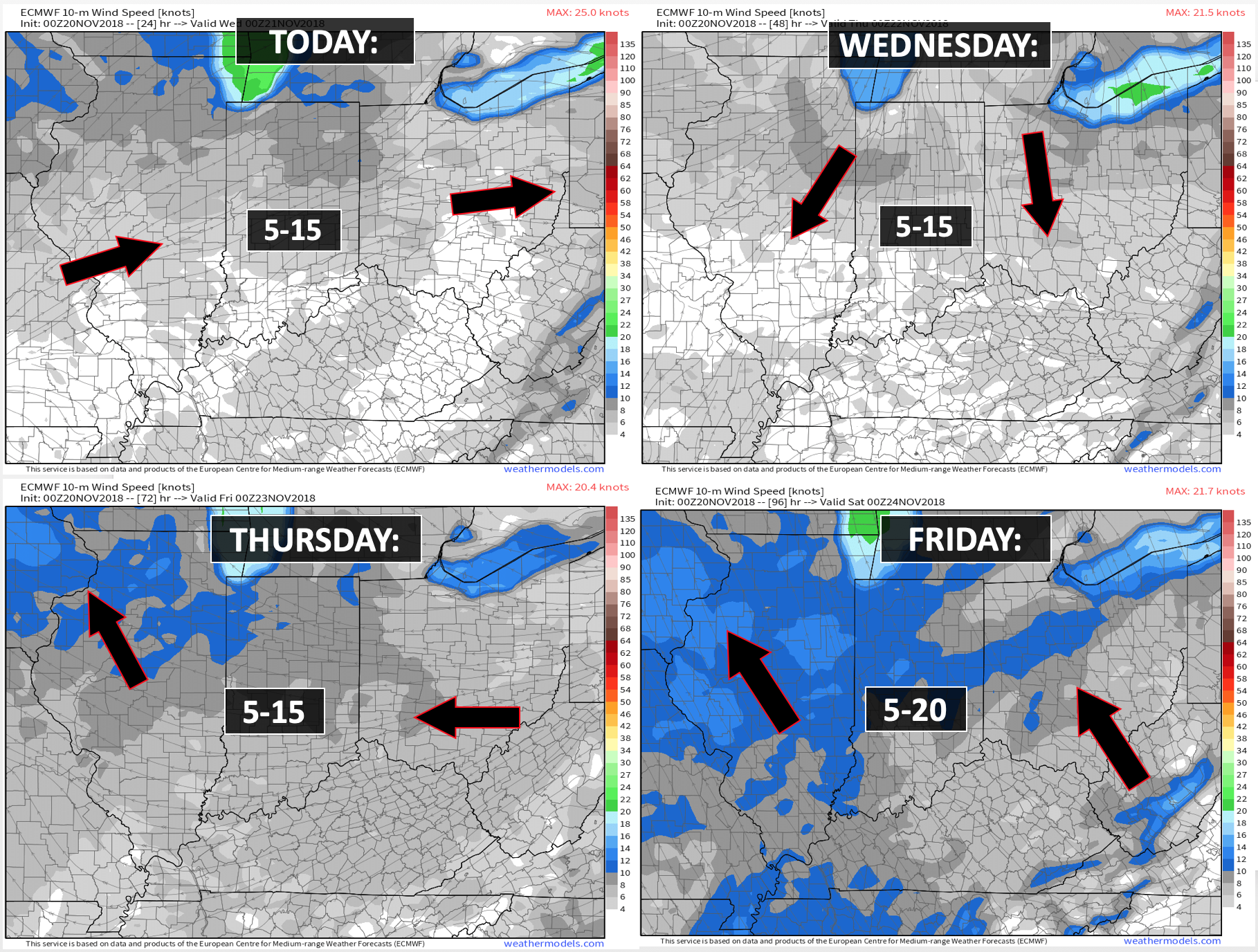

Today through next Sunday morning: Freezing fog possible this morning over NW TN. This could make slick spots on bridges. No significant winter weather anticipated. At this time it appears that we should remain wintry precipitation free over the coming six days.
Sunday afternoon into Monday: Falling temperatures could turn the rain to snow or a wintry mix. Monitor updates.
The Weather Observatory will be holding two open houses for adults and children. Weather permitting, the open house will be Saturday, December 1st.
Class of 1988 (Massac County High School). I will be having a special open house for you on Friday, November 30th (the night before the other open house)

Learn more about the UV index readings. Click here.

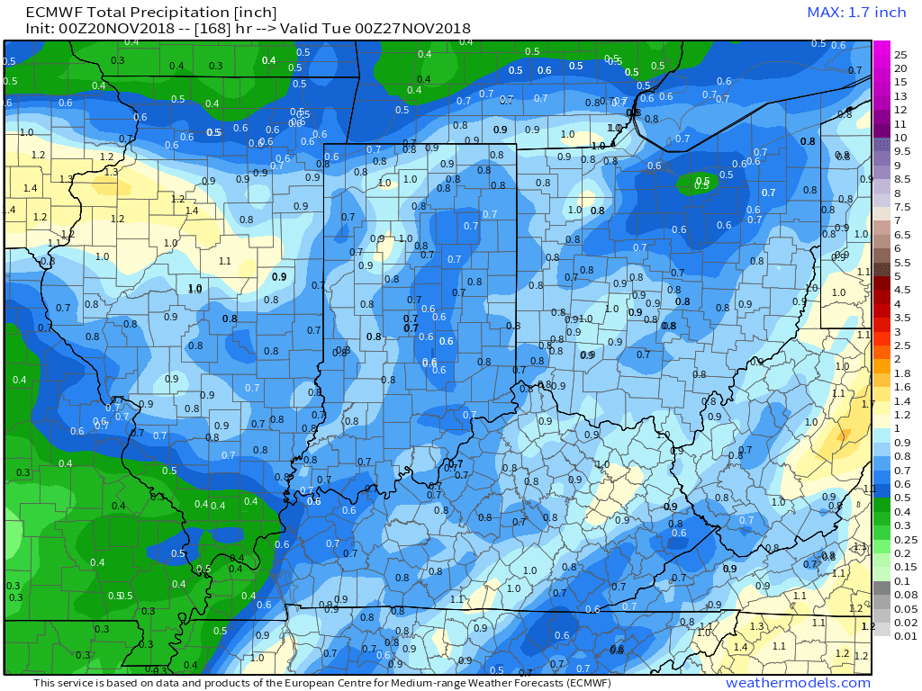
Here is the WPC/NOAA rainfall outlook
Rain will move back into the region Friday and Friday night. Additional rain possible Sunday and Sunday night.
These totals may need updating. Less confident on Sunday’s totals.
Did you know that you can find me on Twitter?

Subscribers, do you need a forecast for an outdoor event?


We offer interactive local city live radars and regional radars.
If a radar does not update then try another one. If a radar does not appear to be refreshing then hit Ctrl F5 on your keyboard.
You may also try restarting your browser. The local city view radars also have clickable warnings.
During the winter months, you can track snow and ice by clicking the winterize button on the local city view interactive radars.

Questions? Broken links? Other questions?
You may email me at beaudodson@usawx.com

The National Weather Service defines a severe thunderstorm as one that produces quarter size hail or larger, 58 mph winds or greater, and/or a tornado.
Today through Saturday: No severe thunderstorms.
Sunday and Monday of next week: I can’t completely rule out a thunderstorm Sunday afternoon. The risk of severe weather appears low. I am monitoring a system. Check back for future updates.
Interactive live weather radar page. Choose the city nearest your location. If one of the cities does not work then try a nearby one. Click here.
National map of weather watches and warnings. Click here.
Storm Prediction Center. Click here.
Weather Prediction Center. Click here.

Live lightning data: Click here.

Interactive GOES R satellite. Track clouds. Click here.

Here are the latest local river stage forecast numbers Click Here.
Here are the latest lake stage forecast numbers for Kentucky Lake and Lake Barkley Click Here.

- More cold weather.
- A bit milder Wednesday and Thursday.
- Widespread rain forms Friday/Friday night.
- Additional event possible Sunday and Sunday night/Monday.
- Snow?
If I told you the cold temperatures were going to continue would you be shocked? I didn’t think so.
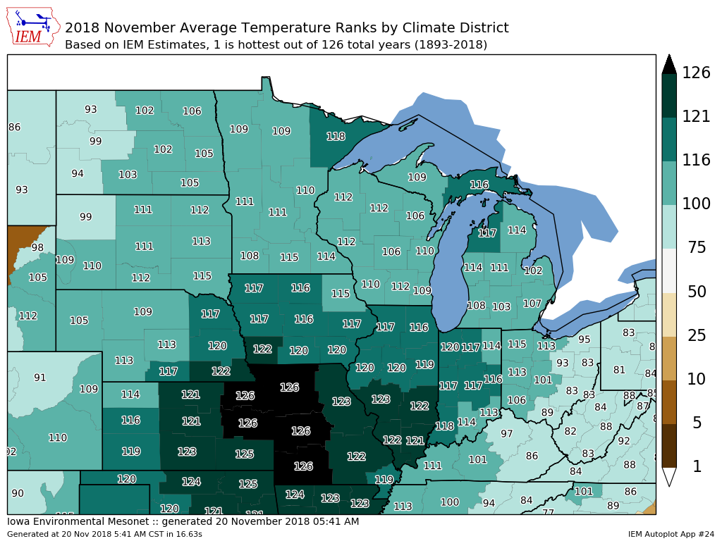
This has been a top five coldest November locally.
Here is the current rank map. 126 means it was the coldest November, thus far.
Click to enlarge.
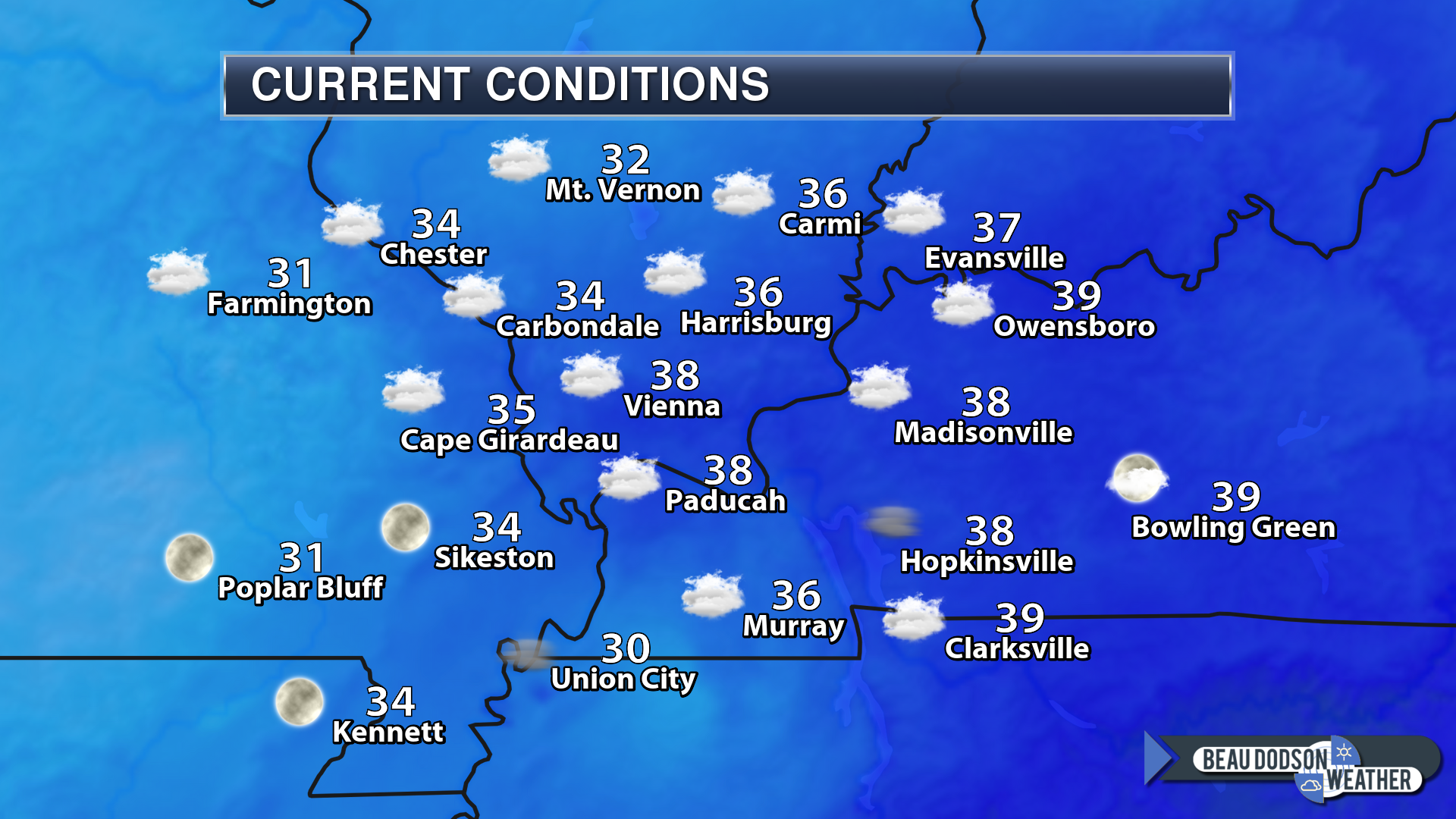
Here were the 6 AM temperatures
Notice the cold spot in NW TN? Monitor that area for icy spots on bridges. There was some freezing fog reported.
Chilly
Dry weather today through Thursday night!
Highs today will only be in the upper 30’s to middle 40’s. That is colder than the normal highs in January. What a strange month this has been. The consistency of the cold is amazing.
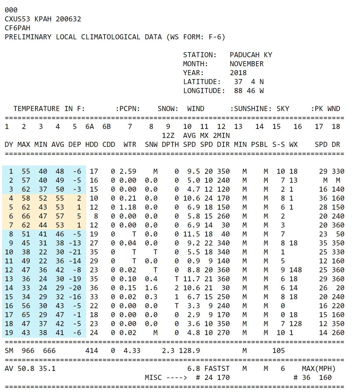
This is the Paducah, KY high and low temperatures for the month, thus far.
Blue is a day with below normal temperatures. Orange is a day with above normal temperatures.
Click to enlarge.
Thanksgiving weather will be superb. No issues locally or regionally.
Rain by Friday:
Clouds increase late Thursday night with rain developing by Friday and Friday night.
The greatest rain coverage may end up being Friday afternoon and evening. This will need to be monitored. Some of the guidance brings it in faster and some a tad slower.
For now, I have the greatest rain chances from Friday afternoon into Friday night.
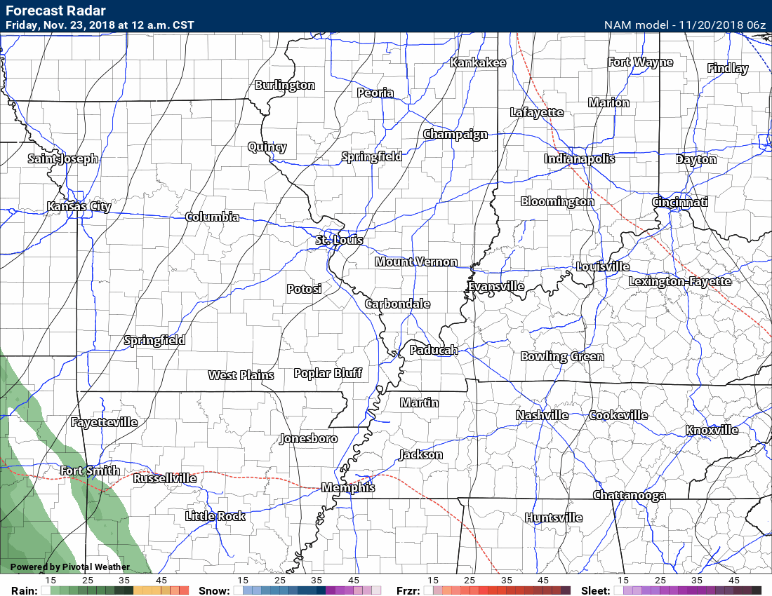
Let’s look at some future-cast radars. This is what the radar might look like Friday/Friday night.
This first animation is from the NAM guidance. Time-stamp upper left.
There are not major differences in the timing between the NAM and GFS model. Small differences.
Plan on rain moving in from the west/southwest during the late morning or afternoon hours.
No severe thunderstorms or flooding. No snow or ice with this one, either.
Green is rain. Darker green is moderate rain.
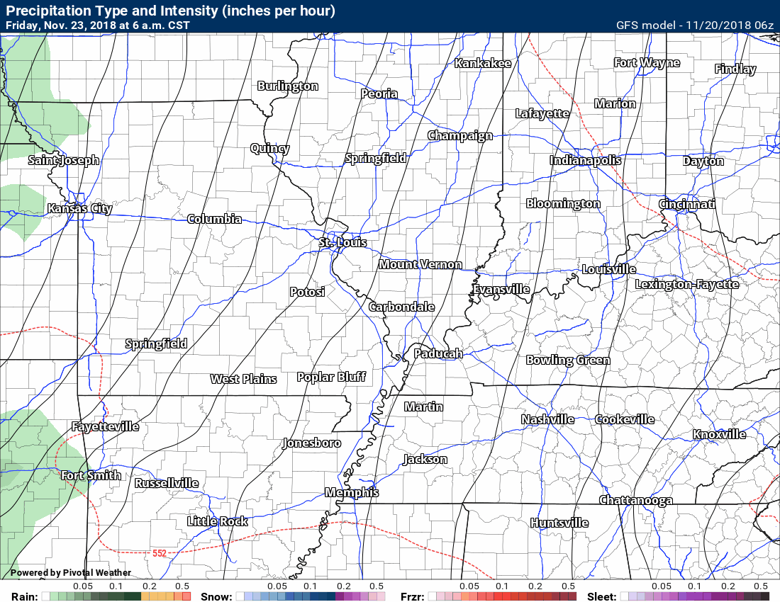
This second animation is from the GFS guidance. Time-stamp upper left.
Green is rain. Darker green is moderate rain.
We dry out briefly on Saturday. Any remaining showers will exit off to the east early in the day (perhaps before sunrise).
Some clouds may linger.
Sunday and Sunday night:
If you have travel plans Sunday/Sunday night then monitor updates. I can’t rule out frozen precipitation across parts of Kansas, Iowa, Missouri, and Illinois. Perhaps to our north and northwest. The track of the system is key to precipitation type.
Another system quickly moves into the region by Sunday and Sunday night. The model depiction of this system is a bit odd.
A rapidly deepening low develops in Missouri and then moves east/northeast into Illinois.
This would bring widespread rain and windy conditions to our region.
Colder air arrives behind the system. This could change the rain to snow. It is too early to know if accumulating snow is in the cards.
Monitor updates.
Here is the GFS depiction of that system. Again, this is the future-cast radar. What radar might look like Sunday and Sunday night.
Green is rain. Blue is snow.
The time stamp is located in the upper left portion of the graphic.
Notice the closely packed black lines? Those are isobars. Equal lines of pressure. That would equal strong and gusty winds Sunday/Sunday night and perhaps a portion of Monday.
Raw wind behind the system with falling temperatures.
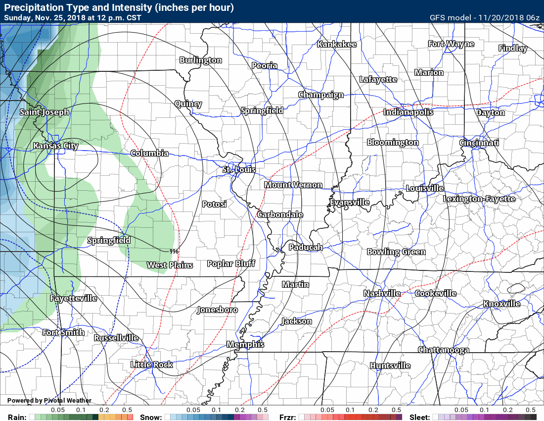
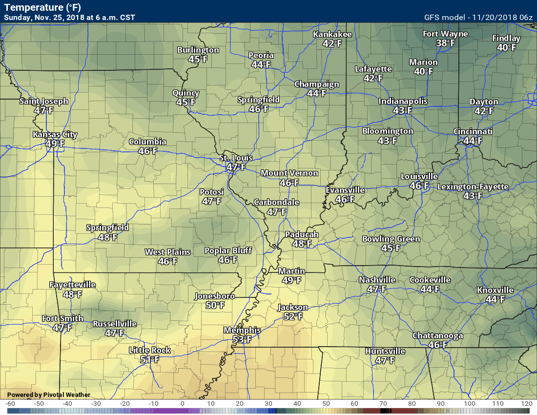
Check out the temperatures.
Notice how warm air surges north ahead of the area of low pressure.
Notice the cold air coming in behind the low.
Typically, the snow is located on the northwest side of the low.
The track of this low is still in question. If it tracks too far north then we won’t have any snow chances locally. For now, I am monitoring trends.
Updated November outlook for subscribers!
![]()

I bring these to you from the BAMwx team. They are excellent long-range forecasters.
Remember, long-range outlooks are a bit of skill, understanding weather patterns, and luck combined. It is not an exact science.

This product is for subscribers.
Subscribe at www.weathertalk.com
Subscriber graphics can be viewed on this page CLICK HERE

This product is for subscribers.

This product is for subscribers.
Subscribe at www.weathertalk.com
Subscriber graphics can be viewed on this page CLICK HERE
![]()
.
Fall Outlook!
These products are for subscribers.
November temperature and precipitation outlook
November temperature outlook
November precipitation outlook
.These products are for subscribers.
![]()

A new weather podcast is now available! Weather Geeks (which you might remember is on The Weather Channel each Sunday)
To learn more visit their website. Click here.
![]()

WeatherBrains Episode 669
Tonight’s Guest WeatherBrain is a CFM who started working for the City of Austin, TX’s Watershed Protection Department as an intern in 1998, and joined the Flood Early Warning System (FEWS) team in 2006. He serves as the Senior Systems Administrator, which is responsible for maintaining all IT hardware and software associated with FEWS. He is also an on-call responder for flood events in Austin. Working with Code for America, Matthew created AtxFloods.com in 2012. Matthew Porcher, welcome to WeatherBrains!
Other discussions in this weekly podcast include topics like:
- Trace of snowfall at Wichita Falls, Texas
- 9.5 inches of snow in parts of Texas Panhandle
- Continued discussion on social media
- Over 5 inches of rainfall in parts of East Alabama
- Astronomy Outlook with Tony Rice
- and more!
Link to their website https://weatherbrains.com/
Previous episodes can be viewed by clicking here.

We offer interactive local city live radars and regional radars. If a radar does not update then try another one. If a radar does not appear to be refreshing then hit Ctrl F5. You may also try restarting your browser.
The local city view radars also have clickable warnings.
During the winter months, you can track snow and ice by clicking the winterize button on the local city view interactive radars.
You may email me at beaudodson@usawx.com
Find me on Facebook!

Find me on Twitter!

Did you know that a portion of your monthly subscription helps support local charity projects?
You can learn more about those projects by visiting the Shadow Angel Foundation website and the Beau Dodson News website.

I encourage subscribers to use the app vs regular text messaging. We have found text messaging to be delayed during severe weather. The app typically will receive the messages instantly. I recommend people have three to four methods of receiving their severe weather information.
Remember, my app and text alerts are hand typed and not computer generated. You are being given personal attention during significant weather events.
