We have some great sponsors for the Weather Talk Blog. Please let our sponsors know that you appreciate their support for the Weather Talk Blog.
Milner and Orr Funeral Home and Cremation Services located in Paducah, Kentucky and three other western Kentucky towns – at Milner and Orr they believe in families helping families. You can find Milner and Orr on Facebook, as well.
![]()
.

Are you in need of new eye glasses? New contacts? Perhaps you need an eye exam. Then be sure and visit the Eye Care Associates of western Kentucky (the Paducah location).
For all of your families eye care needs. Visit their web-site here. Or, you can also visit their Facebook page.
.

Best at Enabling Body Shop Profitability since 1996. Located In Paducah Kentucky and Evansville Indiana; serving all customers in between. They provide Customer Service, along with all the tools necessary for body shops to remain educated and competitive. Click the logo above for their main web-site. You can find McClintock Preferred Finishes on Facebook, as well

Expressway Carwash and Express Lube are a locally owned and operated full service Carwash and Lube established in 1987. They have been proudly serving the community for 29 years now at their Park Avenue location and 20 years at their Southside location. They have been lucky enough to partner with Sidecar Deli in 2015, which allows them to provide their customers with not only quality service, but quality food as well. . If you haven’t already, be sure to make Expressway your one stop shop, with their carwash, lube and deli. For hours of operation and pricing visit www.expresswashlube.com or Expressway Carwash on Facebook.
.
.

.
I have launched the new weather texting service! I could use your help. Be sure and sign up and fully support all of the weather data you see each day.
This is a monthly subscription service. Supporting this helps support everything else. The cost is $3 a month for one phone, $5 a month for three phones, and $10 a month for seven phones.
For more information visit BeauDodsonWeather.com
Or directly sign up at Weathertalk.com


This forecast update covers far southern Illinois, far southeast Missouri, and far western Kentucky. See the coverage map on the right side of the blog..
New! Video page on the main Weather Talk web-site.
I am posting videos on the WeatherTalk website.
The videos can be found under the BeauCast tab. Click here..
..
November 1, 2016
Tuesday Night: Mostly clear.
What impact is expected? None.
My confidence in this part of the forecast verifying: High. This forecast should verify.
Temperatures: Lows in the 58-64 degree range.
Wind Chill: N/A
Winds: South and southwest winds at 5-10 mph
What is the chance for precipitation? MO ~10%. IL ~ 10%. KY ~ 0% . TN ~ 0%
Coverage of precipitation: None
Is severe weather expected? No
Should I cancel my outdoor plans? No
Sunset will be at 5:56 p.m.
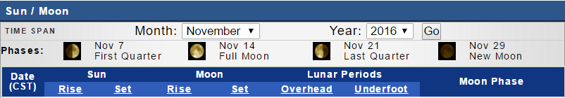
Moonrise will be at 8:51 a.m. and moonset will be at 7:32 p.m. Waxing Crescent.
.
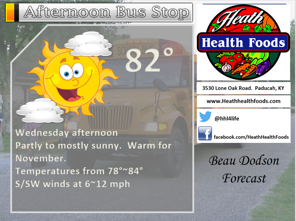
November 2, 2016
Wednesday: Warm. Some increase in clouds through the day. Isolated showers. Breezy, at times. Near record or record high temperatures.
What impact is expected? Wet roadways.
My confidence in this part of the forecast verifying: High. This forecast should verify.
Temperatures: High temperatures in the 78-84 degree range.
Wind Chill: N/A
Winds: East winds becoming south/southwest at 7-14 mph. Perhaps higher gusts.
What is the chance for precipitation? MO ~ 30%. IL ~ 30%. KY ~ 30% . TN ~ 30%
Coverage of precipitation? Isolated to perhaps scattered.
Is severe weather expected? No
Should I cancel my outdoor plans? No, but monitor radars.
Sunrise will be at 7:21 a.m. and sunset will be at 5:55 p.m.
UV Index: 6-9
Moonrise will be at 9:45 a.m. and moonset will be at 8:12 p.m. Waxing Crescent.
.
Wednesday Night: Increasing clouds. A chance for a few showers and thunderstorms (late at night).
What impact is expected? Wet roadways. Lightning.
My confidence in this part of the forecast verifying: Medium. Some adjustments are possible.
Temperatures: Lows in the 58-64 degree range.
Wind Chill: N/A
Winds: South and southwest winds at 3-6 mph
What is the chance for precipitation? MO ~ 50%. IL ~ 50%. KY ~ 40% . TN ~ 30%
Coverage of precipitation: Perhaps scattered.
Is severe weather expected? No
Should I cancel my outdoor plans? No
.
November 3, 2016
Thursday: Mostly cloudy. A good chance for a few morning showers. Thunder possible. Cooler.
What impact is expected? Wet roadways. Perhaps lightning.
My confidence in this part of the forecast verifying: Medium. Some adjustments are possible.
Temperatures: High temperatures in the 66-72 degree range.
Wind Chill: N/A
Winds: Southwest winds becoming north at 6-12 mph. Gusty, at times.
What is the chance for precipitation? MO ~ 60%. IL ~ 60%. KY ~ 60% . TN ~ 50%
Coverage of precipitation? Scattered
Is severe weather expected? No
Should I cancel my outdoor plans? Some showers are a good bet on Thursday. Not an all day rain. Scattered.
Sunrise will be at 7:22 a.m. and sunset will be at 5:54 p.m.
UV Index: 1-3 (cloud cover should keep the UV index lower)
Moonrise will be at 10:36 a.m. and moonset will be at 8:57 p.m. Waxing Crescent.
.
Thursday Night: Clear. Cool temperatures. Perhaps some patchy fog.
What impact is expected? Wet roadways.
My confidence in this part of the forecast verifying: Medium. Some adjustments are possible.
Temperatures: Lows in the 46-52 degree range.
Wind Chill: N/A
Winds: North and northwest winds at 3-6 mph
What is the chance for precipitation? MO ~ 0%. IL ~ 0%. KY ~ 10% . TN ~ 0%
Coverage of precipitation: Mostly likely none.
Is severe weather expected? No
Should I cancel my outdoor plans? No
.
November 4, 2016
Friday: Mostly sunny. Above normal temperatures, but cooler than earlier in the week.
What impact is expected? Most likely none.
My confidence in this part of the forecast verifying: High. This forecast should verify.
Temperatures: High temperatures in the 64-68 degree range.
Wind Chill: N/A
Winds: North and northwest winds 5-10 mph.
What is the chance for precipitation? MO ~ 0%. IL ~ 0%. KY ~ 0% . TN ~ 0%
Coverage of precipitation? None
Is severe weather expected? No
Should I cancel my outdoor plans? No
Sunrise will be at 7:21 a.m. and sunset will be at 5:53 p.m.
UV Index: 6-9
Moonrise will be at 11:26 a.m. and moonset will be at 9:46 p.m. Waxing Crescent.
.
Friday Night: Mostly clear. Patchy fog possible.
What impact is expected?
My confidence in this part of the forecast verifying: High. This forecast should verify.
Temperatures: Lows in the 39 to 44 degree range.
Wind Chill: N/A
Winds: Variable winds at 4-8 mph.
What is the chance for precipitation? MO ~ 0%. IL ~ 0%. KY ~ 0% . TN ~ 0%
Coverage of precipitation: None
Is severe weather expected? No
Should I cancel my outdoor plans? No
.
.
November 5, 2016
Saturday: Mostly sunny. Above normal temperatures will continue.
What impact is expected? None
My confidence in this part of the forecast verifying: High. This forecast should verify.
Temperatures: High temperatures in the 68-74 degree range.
Wind Chill: N/A
Winds: West and northwest winds at 4-8 mph.
What is the chance for precipitation? MO ~ 0%. IL ~ 0%. KY ~ 0% . TN ~ 0%
Coverage of precipitation? None
Is severe weather expected? No
Should I cancel my outdoor plans? No
Sunrise will be at 7:24 a.m. and sunset will be at 5:52 p.m.
UV Index: 6-8
Moonrise will be at 12:12 a.m. and moonset will be at 10:39 p.m. Waxing Crescent.
.
Saturday Night: Mostly clear. Patchy fog possible.
What impact is expected?
My confidence in this part of the forecast verifying: High. This forecast should verify.
Temperatures: Lows in the 44-48 degree range.
Wind Chill: N/A
Winds: North winds at 3-6 mph.
What is the chance for precipitation? MO ~ 0%. IL ~ 0%. KY ~ 0% . TN ~ 0%
Coverage of precipitation: None
Is severe weather expected? No
Should I cancel my outdoor plans? No
.
.
November 6, 2016
Sunday: Mostly sunny. Above normal temperatures continue. Mild.
What impact is expected? None
My confidence in this part of the forecast verifying: High. This forecast should verify.
Temperatures: High temperatures in the 68-74 degree range.
Wind Chill: N/A
Winds: Northeast and east at 5-10 mph
What is the chance for precipitation? MO ~ 0%. IL ~ 0%. KY ~ 0% . TN ~ 0%
Coverage of precipitation? None
Is severe weather expected? No
Should I cancel my outdoor plans? No
Sunrise will be at 6:25 a.m. and sunset will be at 4:51 p.m.
UV Index: 5-7
Moonrise will be at 11:56 a.m. and moonset will be at 10:35 p.m. Waxing Crescent.
.
Sunday Night: Mostly clear.
What impact is expected? None
My confidence in this part of the forecast verifying: Medium. Some adjustments are possible.
Temperatures: Lows in the 43-46 degree range.
Wind Chill: N/A
Winds: Northeast and east at 5-10 mph
What is the chance for precipitation? MO ~ 0%. IL ~ 0%. KY ~ 0% . TN ~ 0%
Coverage of precipitation: None
Is severe weather expected? No
Should I cancel my outdoor plans? No
.
.
November 7, 2016
Monday: Partly sunny. Above normal temperatures will continue.
What impact is expected? None
My confidence in this part of the forecast verifying: Low. Some adjustments are possible.
Temperatures: High temperatures in the 68-74 degree range.
Wind Chill: N/A
Winds: East and southeast at 5-10 mph
What is the chance for precipitation? MO ~ 0%. IL ~ 0%. KY ~ 0% . TN ~ 0%
Coverage of precipitation? None
Is severe weather expected? No
Should I cancel my outdoor plans? No
Sunrise will be at 6:26 a.m. and sunset will be at 4:50 p.m.
UV Index: 5-7
Moonrise will be at 12:37 p.m. and moonset will be at 11:35 p.m. First Quarter.
.
Monday Night: Some increase in clouds.
What impact is expected? None
My confidence in this part of the forecast verifying: Low. Significant adjustments possible.
Temperatures: Lows in the 43-46 degree range.
Wind Chill: N/A
Winds: South and southeast at 5-10 mph
What is the chance for precipitation? MO ~ 0%. IL ~ 0%. KY ~ 0% . TN ~ 0%
Coverage of precipitation: None
Is severe weather expected? No
Should I cancel my outdoor plans? No
.
November 8, 2016
Tuesday: Partly cloudy. Showers possible.
What impact is expected? Wet roadways
My confidence in this part of the forecast verifying: Low. Some adjustments are possible.
Temperatures: High temperatures in the 68-74 degree range.
Wind Chill: N/A
Winds: East and southeast at 5-10 mph
What is the chance for precipitation? MO ~ 30%. IL ~ 30%. KY ~ 30% . TN ~ 30%
Coverage of precipitation?
Is severe weather expected?
Should I cancel my outdoor plans?
Sunrise will be at 6:27 a.m. and sunset will be at 4:49 p.m.
UV Index: 5-7
Moonrise will be at 1:17 p.m. and moonset will be at –:– a.m. Waxing Gibbous
.
Tuesday Night: Partly cloudy. Showers possible.
What impact is expected?
My confidence in this part of the forecast verifying: Low. Significant adjustments possible.
Temperatures: Lows in the 45-50 degree range.
Wind Chill: N/A
Winds: South and southeast at 5-10 mph
What is the chance for precipitation? MO ~ 0%. IL ~ 0%. KY ~ 0% . TN ~ 0%
Coverage of precipitation:
Is severe weather expected?
Should I cancel my outdoor plans?
.
More information on the UV index. Click here
.
The School Bus Stop Forecast is sponsored by Heath Health and Wellness. Located next to Crowell Pools in Lone Oak, Kentucky.
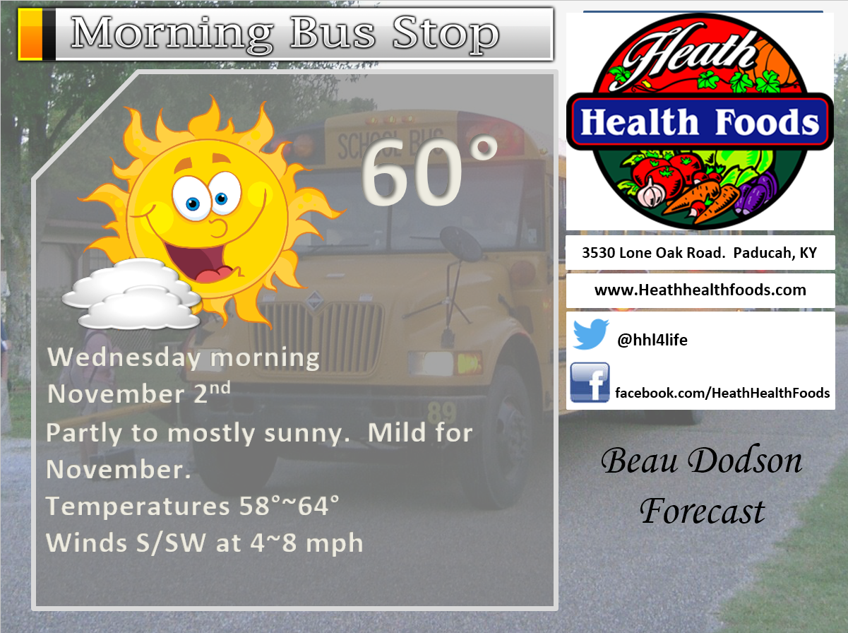
Visit their web-site here. And. visit Heath Health Foods on Facebook!

Heath Health Foods is a locally owned and operated retail health and wellness store. Since opening in February 2006; the store has continued to grow as a ministry with an expanding inventory which also offers wellness appointments and services along with educational opportunities. Visit their web-site here. And. visit Heath Health Foods on Facebook!
The weekend forecast is sponsored by Farmer and Company Real Estate. Click here to visit their site.
.
Farmer & Company Real Estate is proud to represent buyers and sellers in both Southern Illinois and Western Kentucky. With 13 licensed brokers, we can provide years of experience to buyers & sellers of homes, land & farms and commercial & investment properties. We look forward to representing YOU! Follow us on Facebook, as well


Don’t forget to check out the Southern Illinois Weather Observatory web-site for weather maps, tower cams, scanner feeds, radars, and much more! Click here

An explanation of what is happening in the atmosphere over the coming days
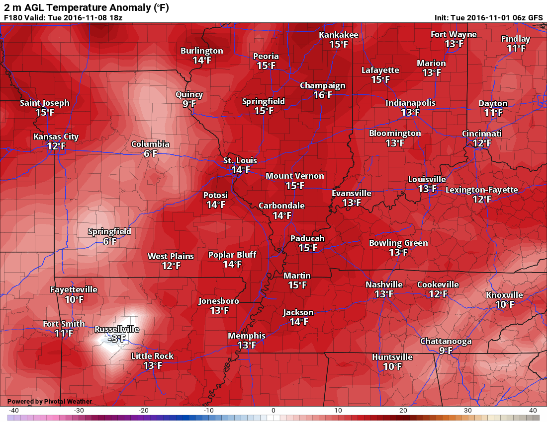
- Record temperatures possible on Wednesday
- Somewhat cooler on Thursday into the weekend
- Rain chances late Wednesday night and Thursday
- Long range
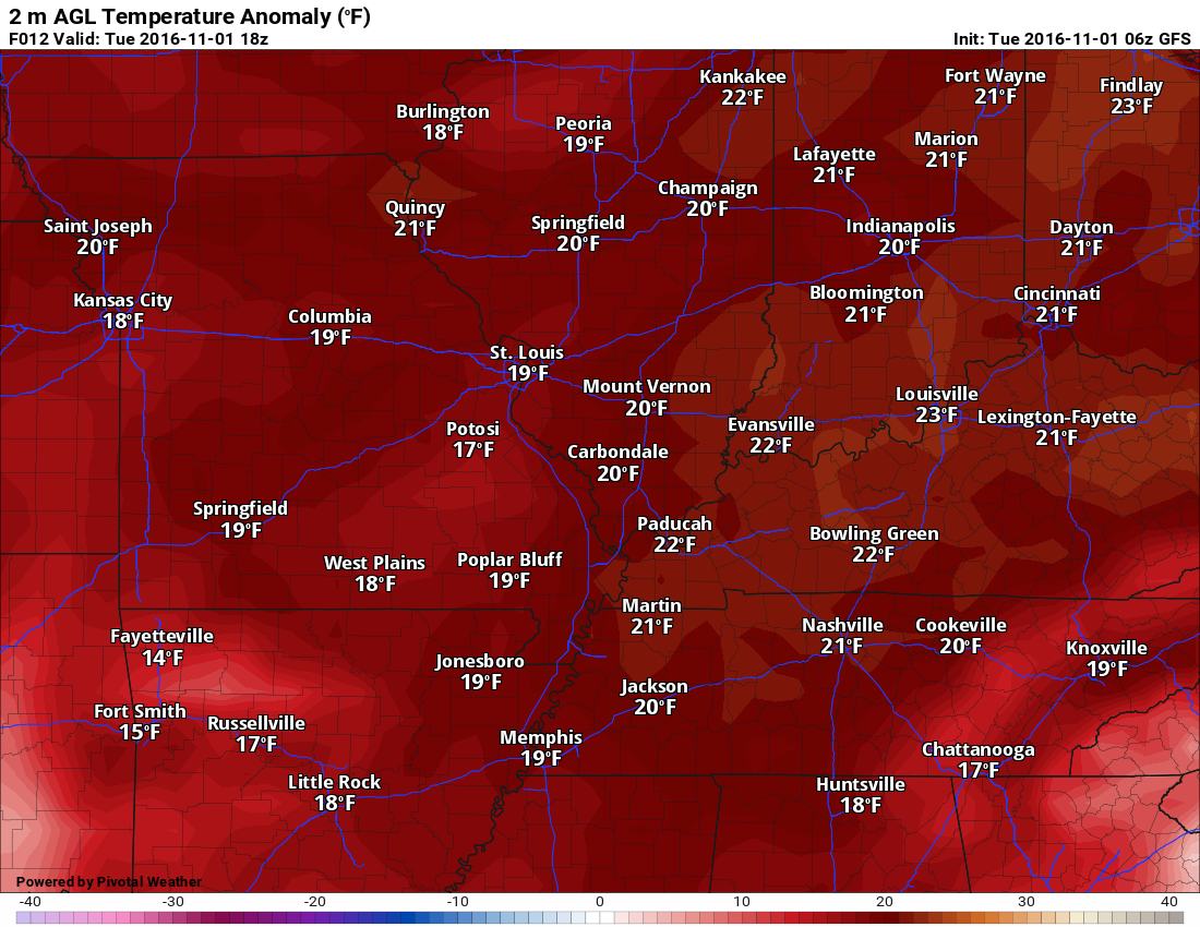
It appears that record warm temperatures will continue to be in the news through Wednesday. Record high temperatures are anticipated for both Tuesday and Wednesday. Highs will range from 82 to 86 degrees. Some reporting stations will experience temperatures twenty degrees above normal. Normal high temperatures are from 60-65 degrees. Normal lows temperatures are from 38 to 42 degrees.
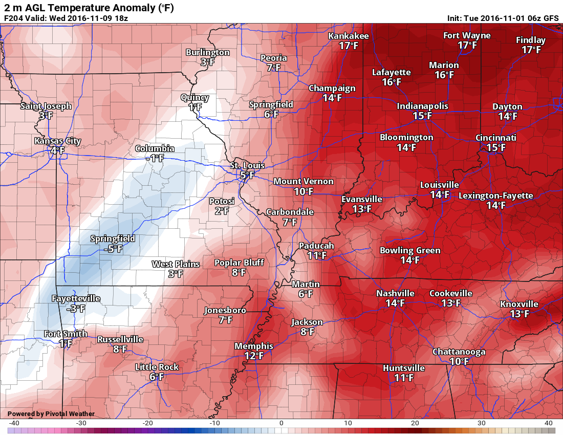
Check out the Tuesday temperature anomaly map. Large departures. Click image to enlarge the map.
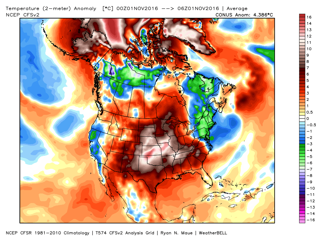
Normal temperatures are not in the forecast through at least next Monday or Tuesday. Par for the course.
October was the third warmest on record for Paducah, Kentucky. It was the warmest October since the 1880’s for Memphis (and many other cities). NCDC will release the final monthly regional numbers in a few days. I suspect some areas had their warmest October on record. I will post those maps (once I receive them).
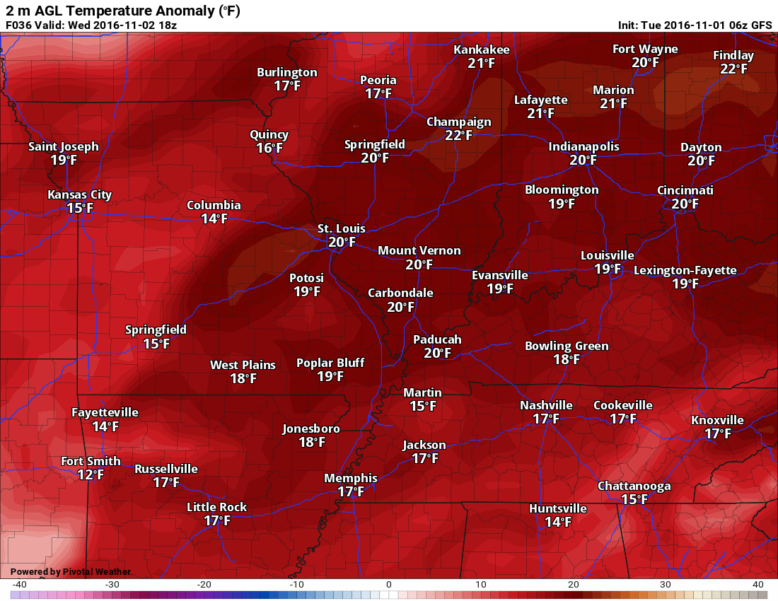
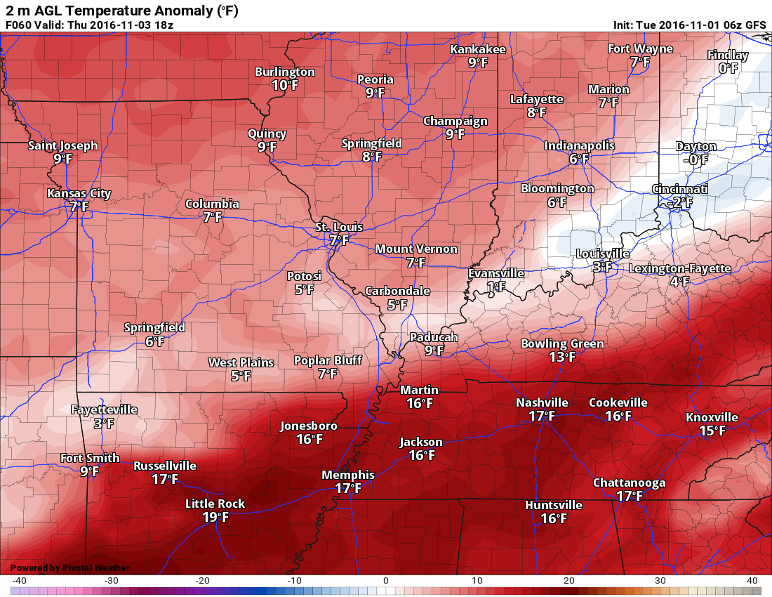
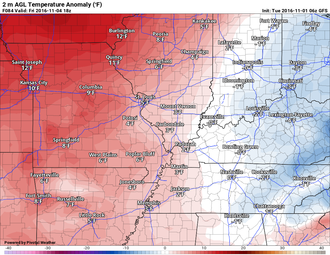
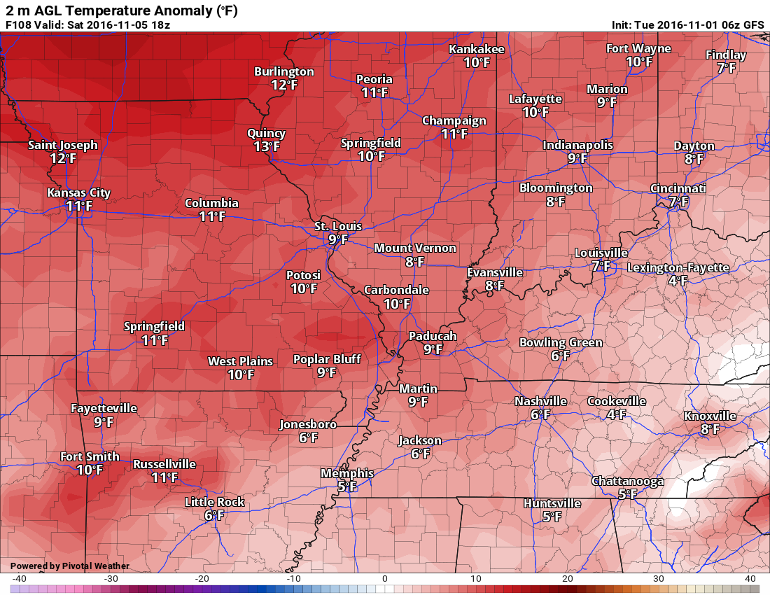
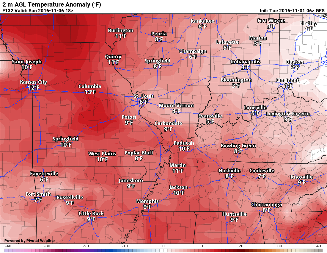
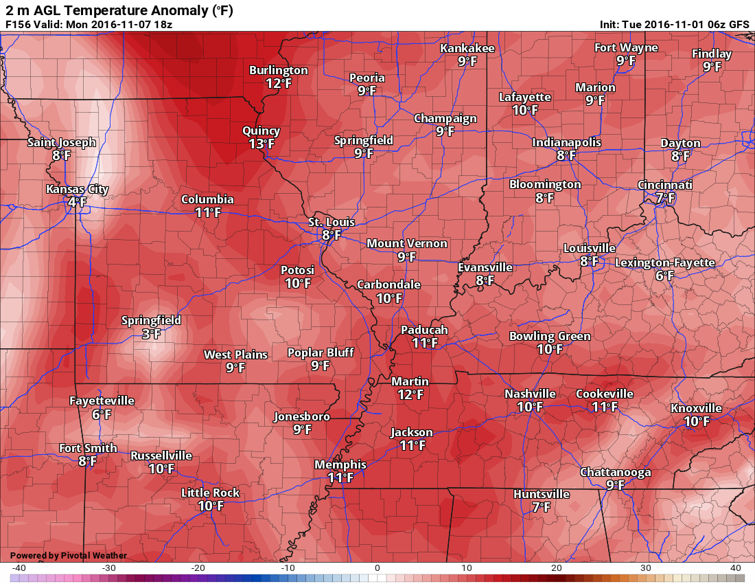
Let’s look at the long range numbers for anomalies. Red equals above normal temperatures. Blue equals below normal temperatures.
Let’s walk through the numbers. Notice what happens as we push into next week. The numbers are not as high. We will likely remain above normal, however, it won’t be as warm as recent weeks.
We stair step down into somewhat cooler air.
Remember, these are the anomalies. Normal highs are in the lower 60’s. If we are 20 degrees above normal then that would equal high temperatures of 80-84.
Tuesday, November 1st
Wednesday, November 2nd
Thursday, November 3rd
Friday, November 4th
Saturday, November 5th
Sunday, November 6th
Monday, November 7th
Tuesday, November 8th
Wednesday, November 9th
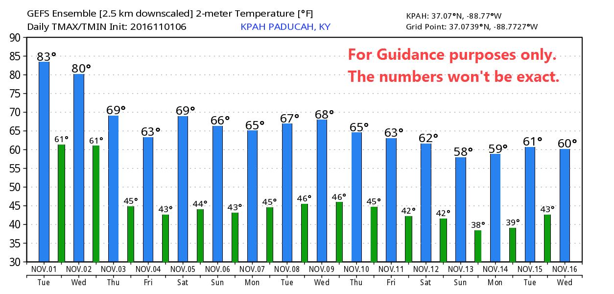
Let me show you the high and low temperatures via the GFS model guidance. This won’t be exact. Use it for guidance. It gives you the general idea. We will stair step down into cooler weather.
Click to enlarge.
Temperature is on the left side of the graphic. Dates are along the bottom of the graphic.
Drought conditions continue to develop. No relief in sight for those in need of significant rain. A cold front will push through the region on Thursday. Some showers and perhaps a thunderstorm will accompany the front. Rainfall totals will range from 0.00″ to 0.30″. Not much and not nearly enough.
The best chance of rain will be after midnight on Wednesday night and then during the morning hours of Thursday. Rain should come to an end from west to east on Thursday afternoon. We might experience clearing sky conditions during Thursday afternoon.
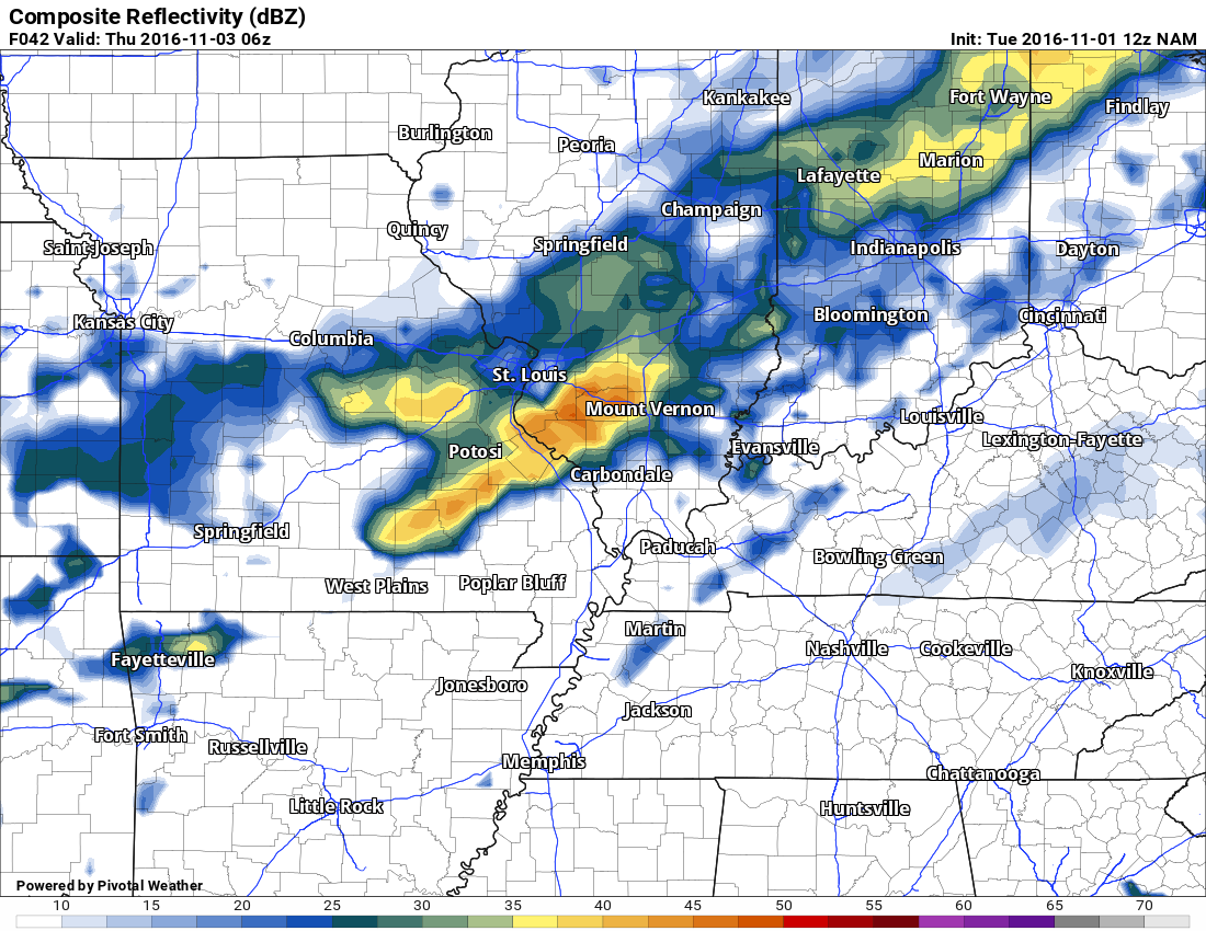
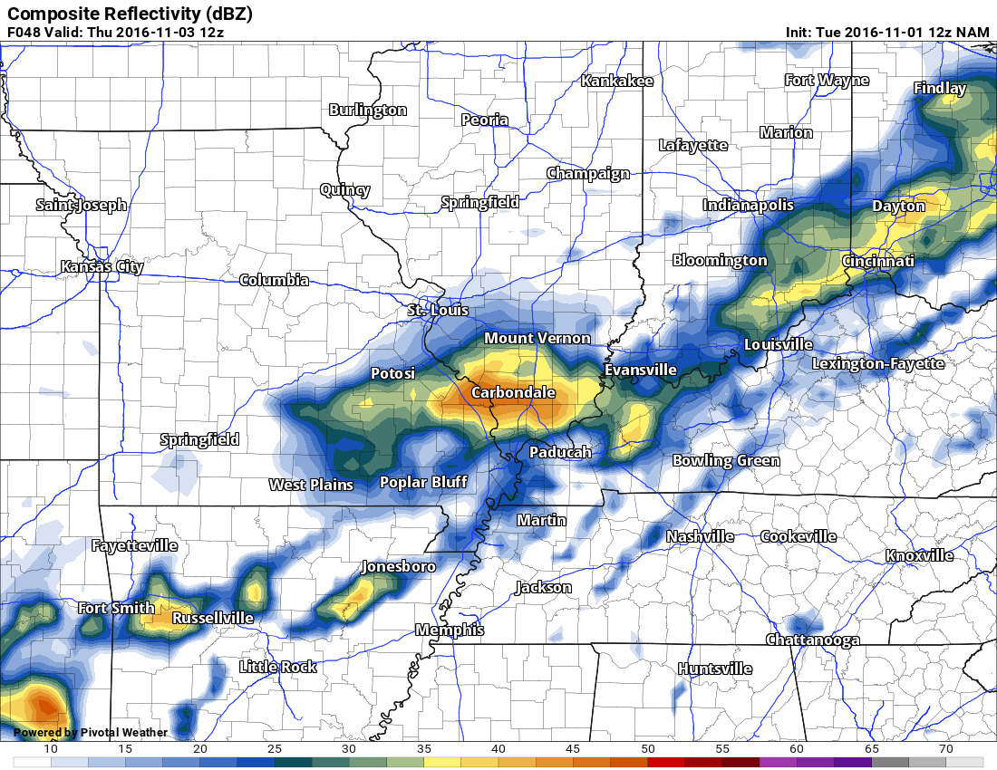
Here is the NAM future-cast radar. What radar might look like as the cold front sweeps through the region on Wednesday night and Thursday.
Use this for guidance. It won’t be exact. It is one models opinion.
This first image is for 1 am on Thursday morning. Click images to enlarge.
You can see some showers and perhaps thunderstorms pushing through our region. No severe weather anticipated.
.
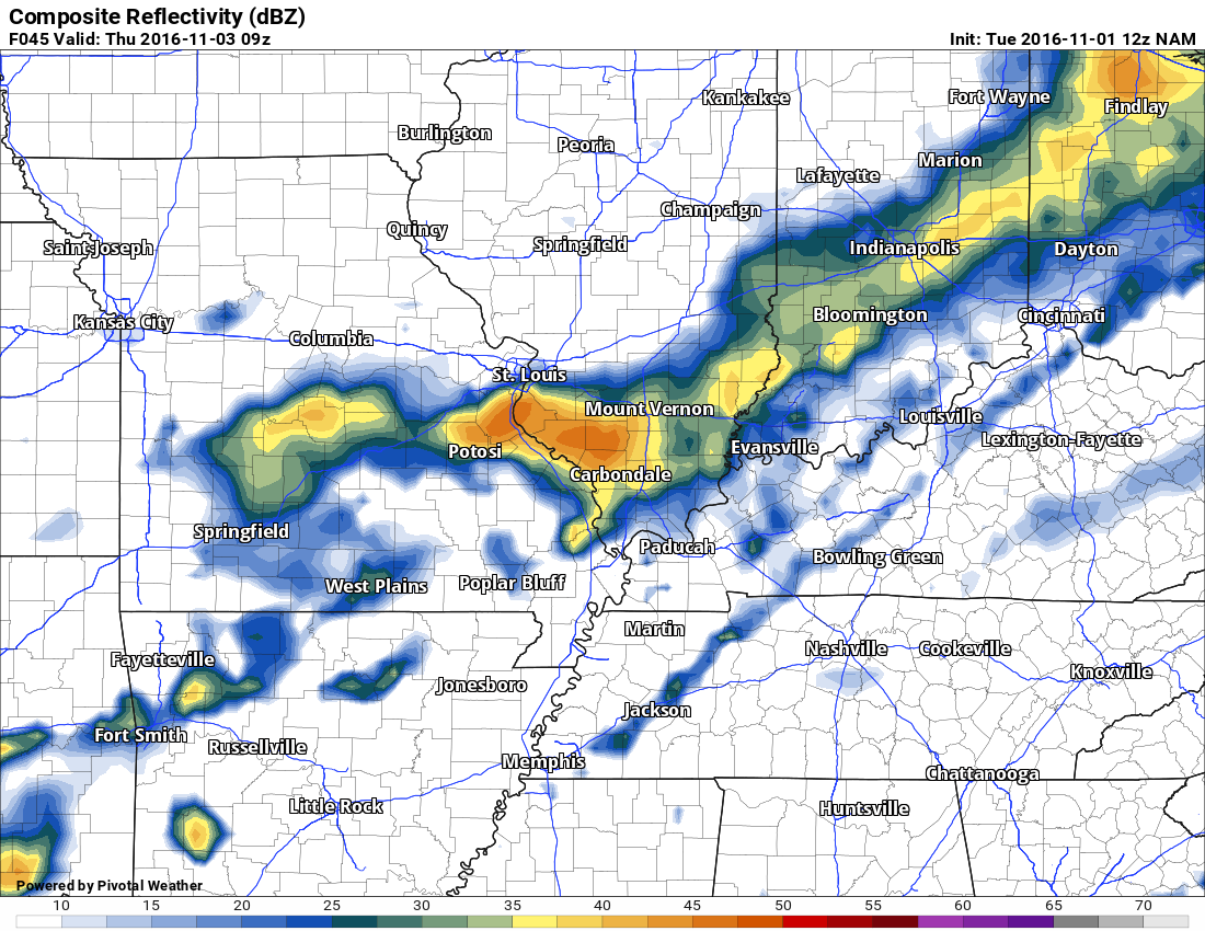
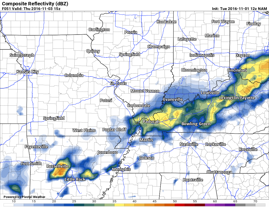
This next image is for 4 am on Thursday morning
.
Here is the 7 am Thursday morning future-cast radar
.
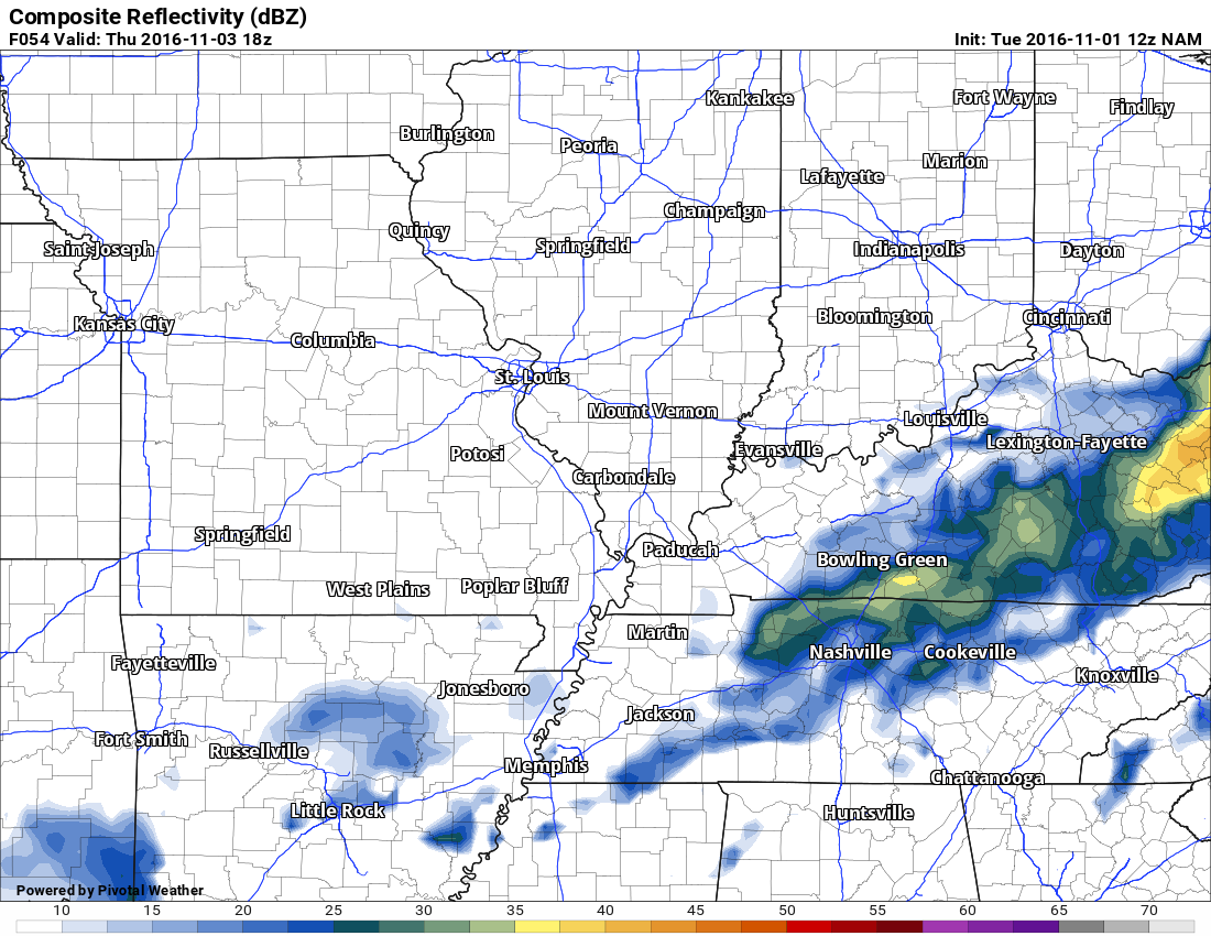
Here is the 10 am Thursday morning radar
.
Here is the 1 pm Thursday afternoon
You can see that rain is on the way out of our region by Thursday afternoon. Perhaps some clearing of the clouds?
.
Once the Thursday system moves away from our region, you can expect dry weather through early next week. Perhaps another rain system next Wednesday or Thursday. I will need to work on the timing of that event.
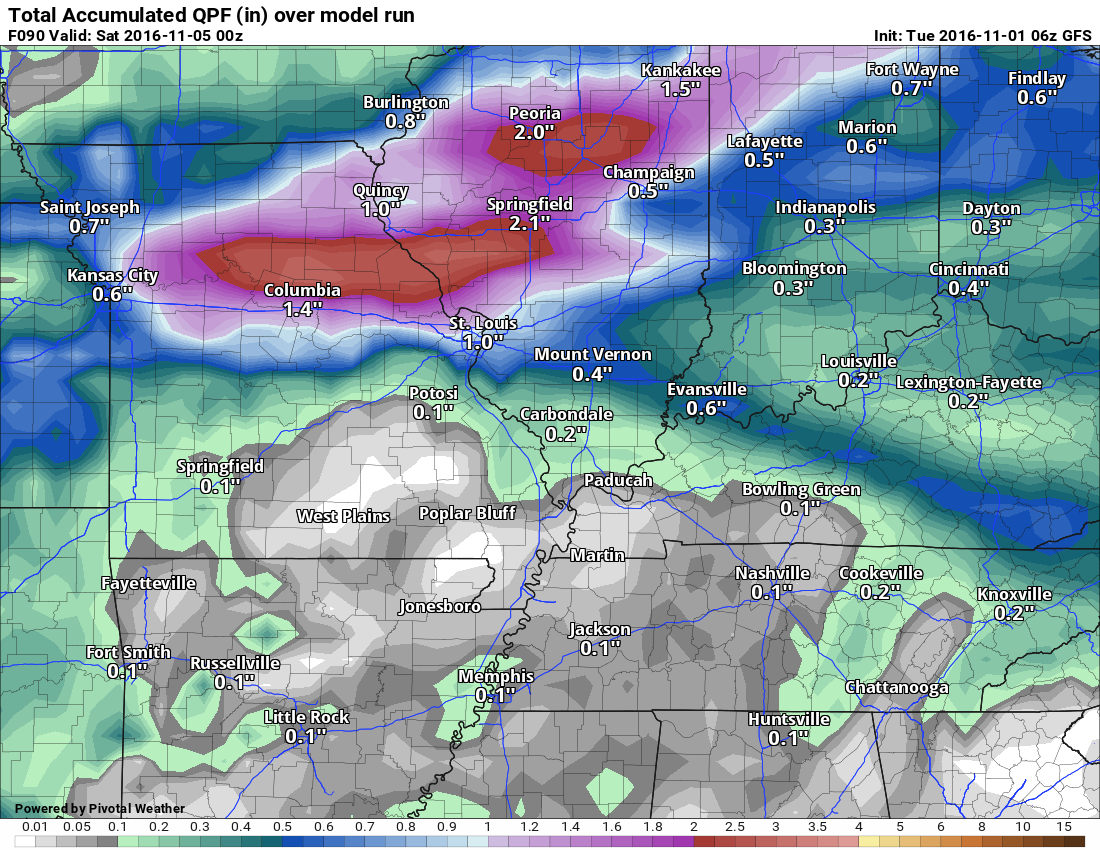
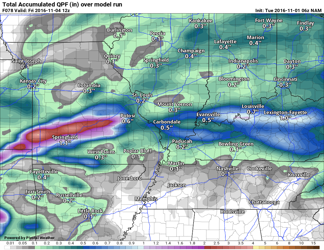
Let’s take a look at the rainfall totals from the different model guidance packages. This is for the Thursday event.
The NAM guidance is painting a band of heavier precipitation over portions of southeast Missouri and southern Illinois. This is an outlier solution. I will monitor trends. See graphic below.
Here are three different models showing you potential rainfall totals for the Thursday cold front.
GFS
GEM
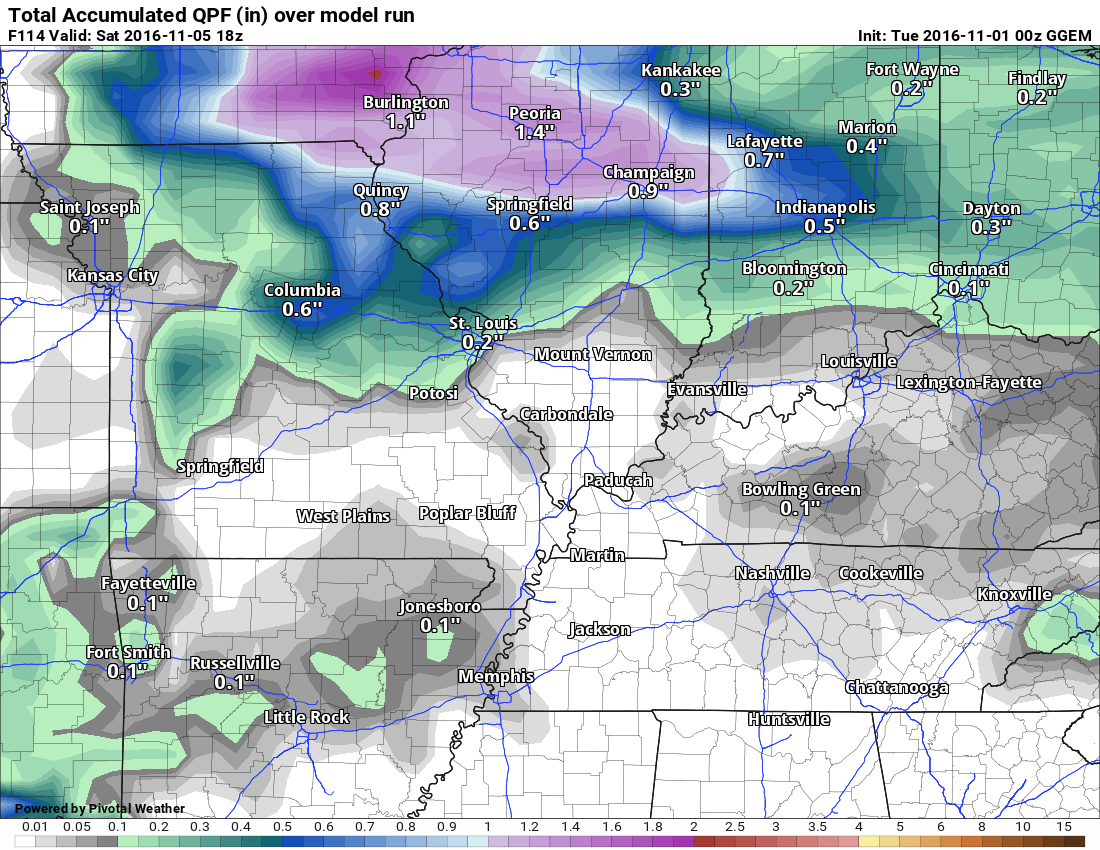
NAM
Notice the NAM has a heavier band of precipitation across southern Missouri into parts of Illinois.
Many of you are asking about the winter forecast. It is still a bit early for certainty. Long range forecasting is like going to Vegas. A little bit of skill and a lot of luck. There are many meteorologists calling for a colder than normal winter. That would include December through February. The average of those three months would equal below normal temperatures.
Keep in mind, cold weather does not always equal snow. Time will tell. I am not a big fan of long range forecasting. There is not a scientific way of forecasting what is really important. The specifics. Yes, I could tell you cooler or warmer than normal, but I can’t tell you whether there will be 20 inches of snow or no snow at all. There is no way of forecasting specific events. Period.
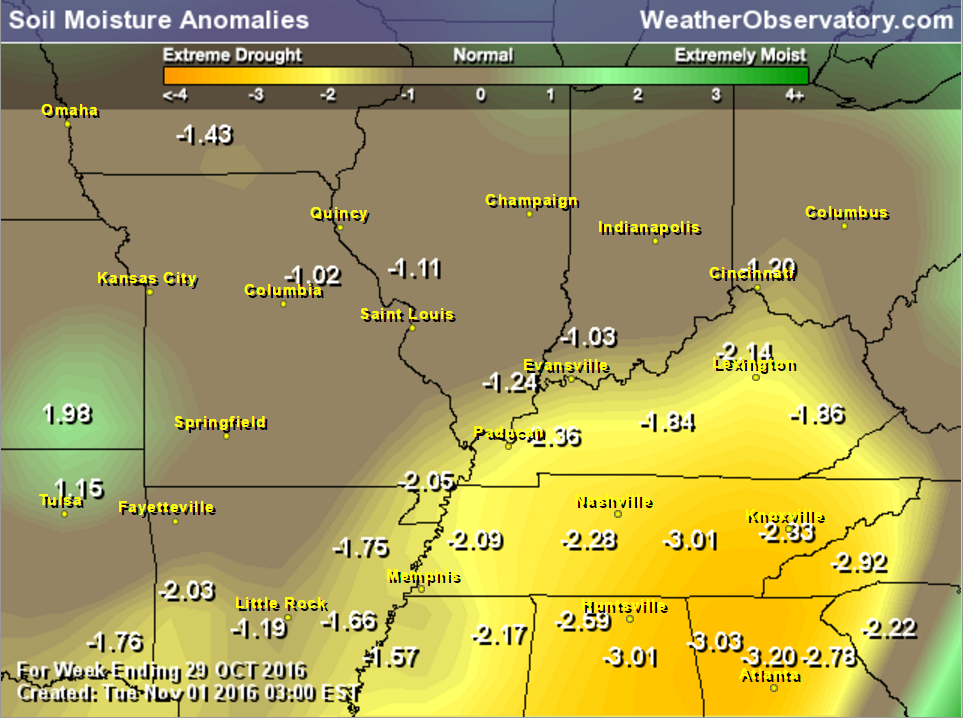
Our region needs rain. It is dry. No secret there. Let’s look at a few maps.
Here is the soil moisture anomaly map. Dry. Drought conditions are developing in our local area.
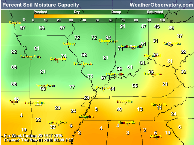
Here is the percent of soil moisture capacity. Again, dry.
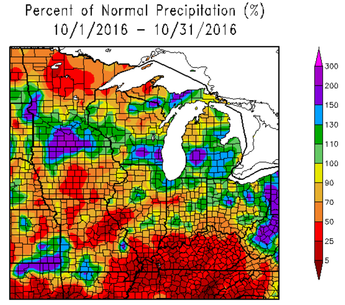
Here is the percent of normal rainfall for the Month of October. Portions of our region experienced little in the way of measurable rainfall.
How much rain is NOAA/WPC forecasting over the coming days?
WPC/NOAA rainfall forecast
No rain in our forecast through Wednesday afternoon.
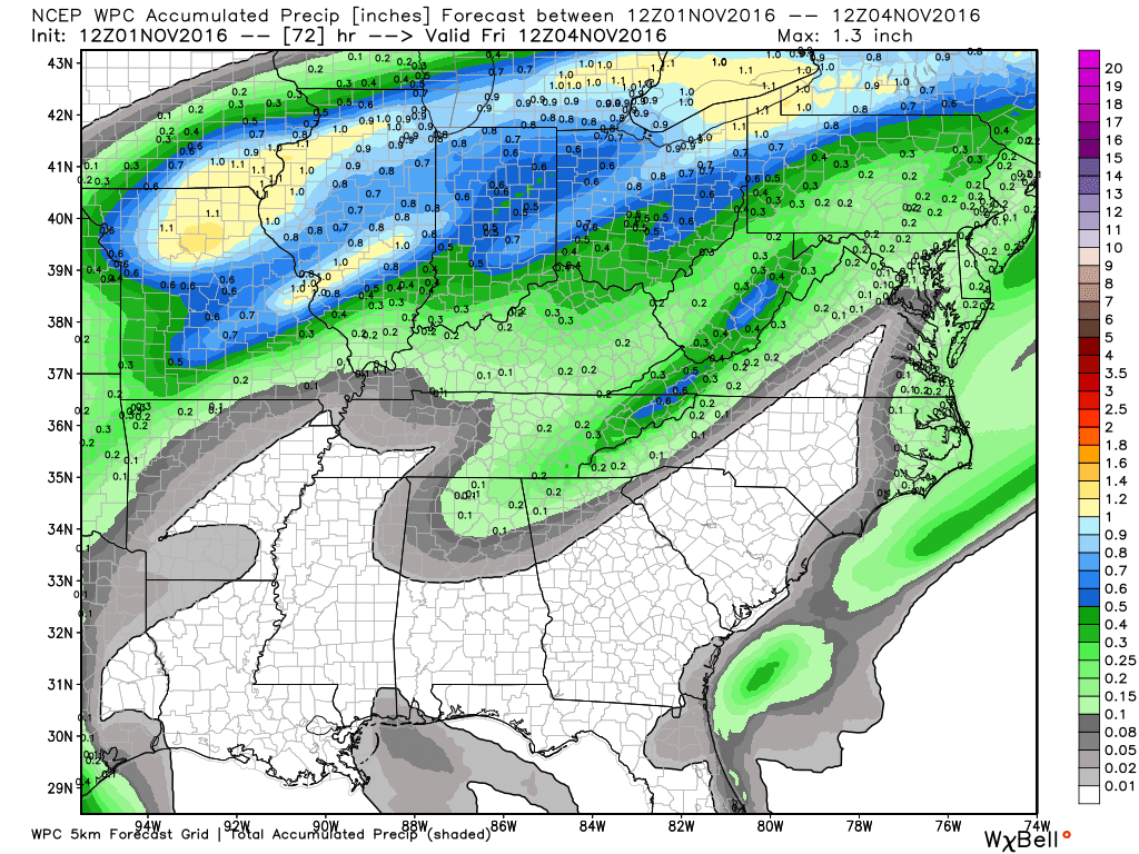
Here is the rainfall forecast for the Thursday rain event.
Click image to enlarge
.
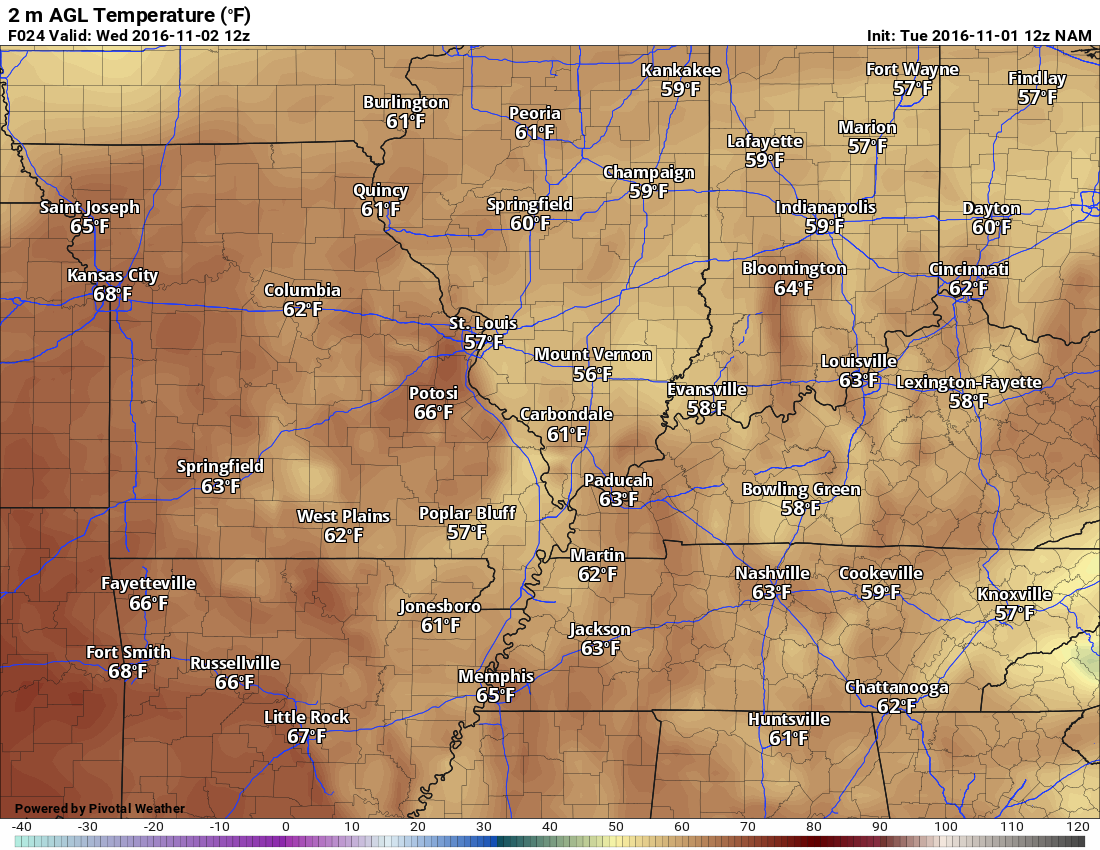
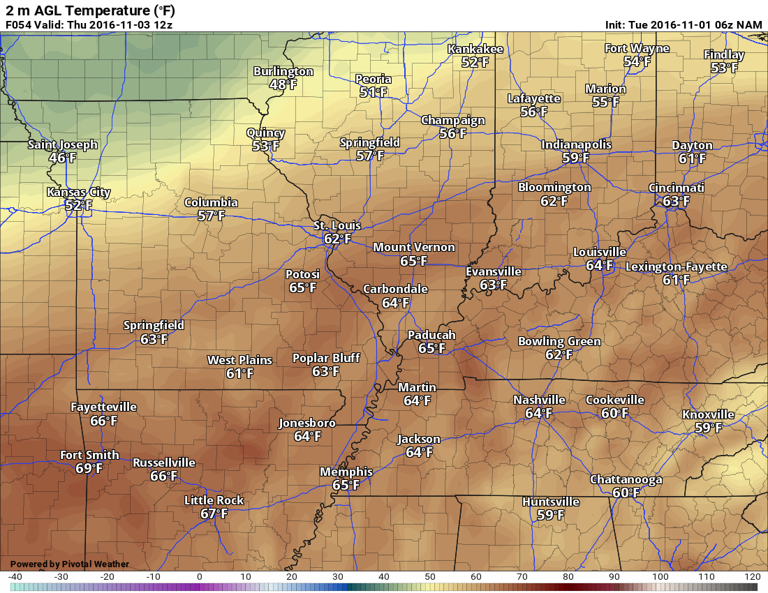
Wednesday morning low temperatures
.
.
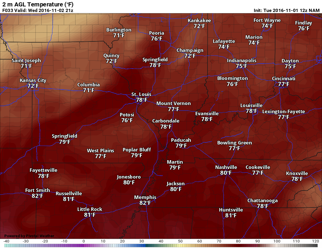
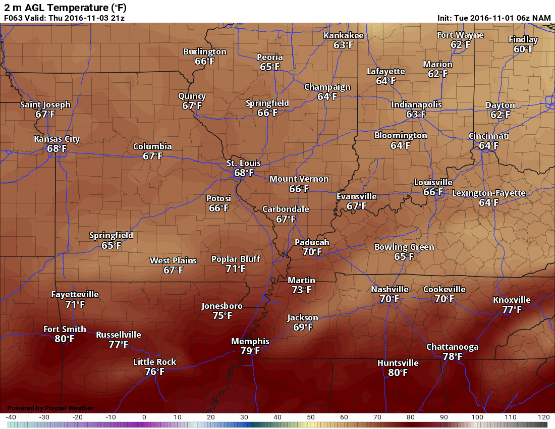
Wednesday afternoon 4 pm temperatures
Expect many areas to rise into the lower 80’s on Wednesday afternoon.
.
.
.
.
.
..


We have regional radars and local city radars – if a radar does not seem to be updating then try another one. Occasional browsers need their cache cleared. You may also try restarting your browser. That usually fixes the problem. Occasionally we do have a radar go down. That is why I have duplicates. Thus, if one fails then try another one.
If you have any problems then please send me an email beaudodson@usawx.com
WEATHER RADAR PAGE – Click here —
We also have a new national interactive radar – you can view that radar by clicking here.
Local interactive city radars include St Louis, Mt Vernon, Evansville, Poplar Bluff, Cape Girardeau, Marion, Paducah, Hopkinsville, Memphis, Nashville, Dyersburg, and all of eastern Kentucky – these are interactive radars. Local city radars – click here

Live Lightning Data – zoom and pan: Click here
Live Lightning Data with sound (click the sound button on the left side of the page): Click here

Can we expect severe thunderstorms over the next 24 to 48 hours? Remember that a severe thunderstorm is defined as a thunderstorm that produces 58 mph winds or higher, quarter size hail or larger, and/or a tornado.
.
Tuesday night through Monday: Severe weather is not anticipated.
.

.No major changes in this update.
.

.
No major concerns, at this time.
.
..

 The latest 8-14 day temperature and precipitation outlook. Note the dates are at the top of the image. These maps DO NOT tell you how high or low temperatures or precipitation will be. They simply give you the probability as to whether temperatures or precipitation will be above or below normal.


Here are the current river stage forecasts. You can click your state and then the dot for your location. It will bring up the full forecast and hydrograph.

Who do you trust for your weather information and who holds them accountable?
I have studied weather in our region since the late 1970’s. I have 37 years of experience in observing our regions weather patterns. I hold a Bachelor’s of Science in Geo-sciences with a concentration in Broadcast Meteorology. I graduated from Mississippi State University.
My resume includes:
Member of the American Meteorological Society.
NOAA Weather-Ready Nation Ambassador.
Meteorologist for McCracken County Emergency Management. I served from 2005 through 2015
Meteorologist for the McCracken County Rescue Squad 2015-current
I own and operate the Southern Illinois Weather Observatory.
Recipient of the Mark Trail Award, WPSD Six Who Make A Difference Award, Kentucky Colonel, and the Caesar J. Fiamma” Award from the American Red Cross.
In 2009 I was presented with the Kentucky Office of Highway Safety Award.
Recognized by the Kentucky House of Representatives for my service to the State of Kentucky leading up to several winter storms and severe weather outbreaks.
I am also President of the Shadow Angel Foundation which serves portions of western Kentucky and southern Illinois.
There is a lot of noise on the internet. A lot of weather maps are posted without explanation. Over time you should learn who to trust for your weather information.
My forecast philosophy is simple and straight forward.
- Communicate in simple terms
- To be as accurate as possible within a reasonable time frame before an event
- Interact with you on Twitter, Facebook, and the blog
- Minimize the “hype” that you might see on television or through other weather sources
- Push you towards utilizing wall-to-wall LOCAL TV coverage during severe weather events
I am a recipient of the Mark Trail Award, WPSD Six Who Make A Difference Award, Kentucky Colonel, and the Caesar J. Fiamma” Award from the American Red Cross. In 2009 I was presented with the Kentucky Office of Highway Safety Award. I was recognized by the Kentucky House of Representatives for my service to the State of Kentucky leading up to several winter storms and severe weather outbreaks.
If you click on the image below you can read the Kentucky House of Representatives Resolution.

Many of my graphics are from www.weatherbell.com – a great resource for weather data, model data, and more


You can sign up for my AWARE email by clicking here I typically send out AWARE emails before severe weather, winter storms, or other active weather situations. I do not email watches or warnings. The emails are a basic “heads up” concerning incoming weather conditions.