We have some great sponsors for the Weather Talk Blog. Please let our sponsors know that you appreciate their support for the Weather Talk Blog.
Milner and Orr Funeral Home and Cremation Services located in Paducah, Kentucky and three other western Kentucky towns – at Milner and Orr they believe in families helping families. You can find Milner and Orr on Facebook, as well.
![]()
.

Wortham Dental Care located in Paducah, Kentucky. The gentle dentist. Mercury free dentistry. They also do safe Mercury removal. You can find Wortham Dental Care on Facebook, as well
.

For all of your families eye care needs. Visit their web-site here. Or, you can also visit their Facebook page.
.

Endrizzi’s Storm Shelters – For more information click here. Endrizzi Contracting and Landscaping can be found on Facebook, as well – click here
.

Best at Enabling Body Shop Profitability since 1996. Located In Paducah Kentucky and Evansville Indiana; serving all customers in between. They provide Customer Service, along with all the tools necessary for body shops to remain educated and competitive. Click the logo above for their main web-site. You can find McClintock Preferred Finishes on Facebook, as well
.

This forecast update covers far southern Illinois, far southeast Missouri, and far western Kentucky. See the coverage map on the right side of the blog.
Remember that weather evolves. Check back frequently for updates, especially during active weather.
The forecast numbers below may vary a bit across the region. These are the averages.—
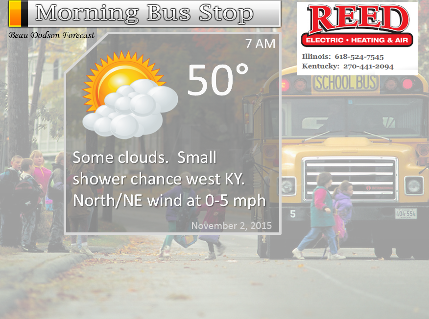
Sunday night – Cloudy. Patchy fog. A shower possible (mainly over our southern and southeastern counties in the Missouri Bootheel into western Kentucky and Tennessee)
Temperatures: Lows ranging from 48 to 54 degrees
Winds: Calm winds.
What is the chance for precipitation? 20% for southern counties in western Kentucky
Coverage of precipitation? Isolated if anything at all
My confidence in this part of the forecast verifying is High
Should I cancel my outdoor plans? No
Is severe weather expected? No
N What impact is expected? Wet roadways if a shower forms
WEATHER RADAR PAGE – Click Here
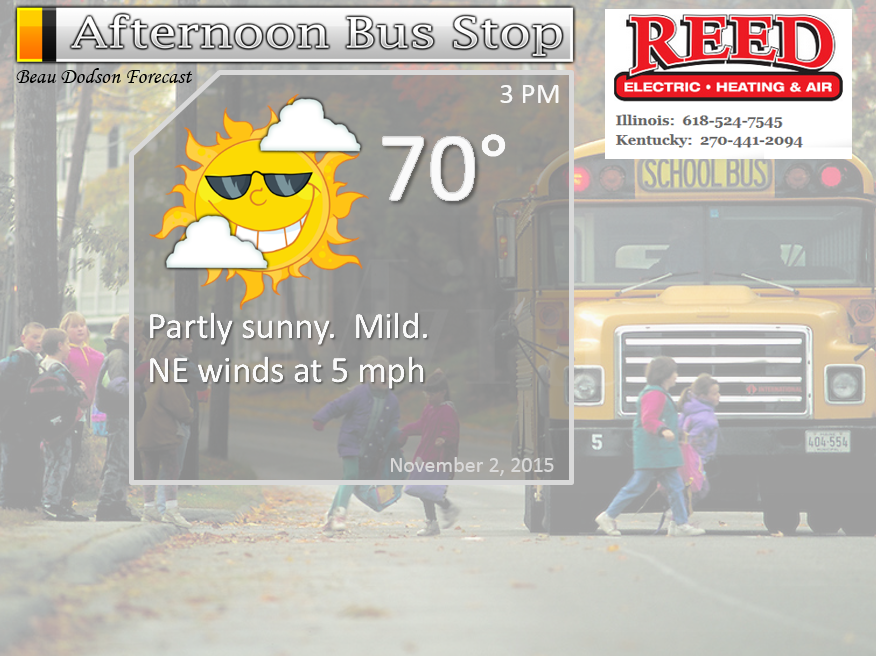
Monday – Mix of sun and clouds. Morning fog. Small chance for a shower over our southeastern counties (near KY/TN border).
Temperatures: Highs in the lower 70s
Winds: Variable winds at 5 mph.
What is the chance for precipitation? 20% (but monitor updates)
Coverage of precipitation? None to isolated over southeastern counties
My confidence in this part of the forecast verifying is High
Should I cancel my outdoor plans? No
Is severe weather expected? No
What impact is expected? None
Monday night – Partly cloudy. Maybe some patchy fog.
Temperatures: Lows ranging from 50 to 54 degrees
Winds: Southwest at 0-5 mph
What is the chance for precipitation? 0%
Coverage of precipitation? None
My confidence in this part of the forecast verifying is High
Should I cancel my outdoor plans? No
Is severe weather expected? No
What impact is expected? None
Tuesday – A mix of sun and clouds. Very mild for October.
Temperatures: Highs in the lower 70’s
Winds: East/southeast winds at 5-10 mph.
What is the chance for precipitation? 0%
Coverage of precipitation? None
My confidence in this part of the forecast verifying is High
Should I cancel my outdoor plans? No
Is severe weather expected? No
What impact is expected? None
Tuesday night – A few clouds.
Temperatures: Lows ranging from 52 to 56 degrees
Winds: South/southeast at 5 mph
What is the chance for precipitation? 0%
Coverage of precipitation? None
My confidence in this part of the forecast verifying is High
Should I cancel my outdoor plans? No
Is severe weather expected? No
What impact is expected? None
Wednesday – A mix of sun and clouds. Mild for October.
Temperatures: Highs in the lower to middle 70’s
Winds: South winds at 5-10 mph.
What is the chance for precipitation? 0%
Coverage of precipitation? None
My confidence in this part of the forecast verifying is High
Should I cancel my outdoor plans? No
Is severe weather expected? No
What impact is expected? None
Wednesday night – An increase in clouds.
Temperatures: Lows in the middle to upper 50s
Winds: South at 5-10 mph
What is the chance for precipitation? 0%
Coverage of precipitation? None
My confidence in this part of the forecast verifying is High
Should I cancel my outdoor plans? No
Is severe weather expected? No
What impact is expected? None
Thursday – Quite a few clouds.
Temperatures: Highs in the lower to middle 70’s
Winds: South/southeast winds at 5-10 mph.
What is the chance for precipitation? 10%
Coverage of precipitation? None
My confidence in this part of the forecast verifying is Medium
Should I cancel my outdoor plans? No
Is severe weather expected? No
What impact is expected? None
Thursday night – Cloudy. A shower or thunderstorm possible. Again, watching the timing of the next cold front.
Temperatures: Lows in the upper 50s
Winds: South at 5-10 mph
What is the chance for precipitation? 30%
Coverage of precipitation? Scattered
My confidence in this part of the forecast verifying is Medium
Should I cancel my outdoor plans? Monitor updates
Is severe weather expected? No
What impact is expected? Some wet roads and perhaps lightning
Friday – A chance for showers and thunderstorms as a cold front moves through the area.
Temperatures: Highs in the upper 60s to around 70 degrees.
Winds: South/southeast winds at 5-10 mph.
What is the chance for precipitation? 40% (could be higher)
Coverage of precipitation? Scattered
My confidence in this part of the forecast verifying is Medium
Should I cancel my outdoor plans? No, but let’s monitor trends
Is severe weather expected? No
What impact is expected? Maybe wet roadways and lightning
The School Bus Stop Forecast is sponsored by Reed Electric, Heating & Air in Metropolis, IL offers full electrical, heating, and air conditioning services, as well as automatic transfer generators. Our licensed and insured service technicians serve Southern Illinois and Western KY with 24 hour service. Free estimates available for all new installations!
Click their ad below to visit their web-site or click here reedelec.com


![]()


Don’t forget to check out the Southern Illinois Weather Observatory web-site for weather maps, tower cams, scanner feeds, radars, and much more! Click here

An explanation of what is happening in the atmosphere over the coming days…
Highlights
1. Weak system passing to our south on Sunday night and Monday
2. An incredible week of weather ahead of us. November? Tell nature that
3. Rain by Thursday night or Friday. New cold front. Showers/storms.
4. Colder by the weekend.
Some patchy dense fog tonight and Monday morning. Same for Monday night.
A weak storm system will pass to our south on Sunday night and early Monday morning. There could be a couple of showers over our southern counties. Those would mainly be the Missouri Bootheel (low chance) and then along the Kentucky and Tennessee border.
Here is the WRF model guidance for late Sunday night and Monday morning. The patchy green represents rain showers. Image is from weatherbell.com
You can see the bulk of this system passes to our south and east. Will this be our winter theme? Southern storm systems? Possibly. The southern branch of the jet stream is forecast to be stronger this year. We could have an active southern storm track.
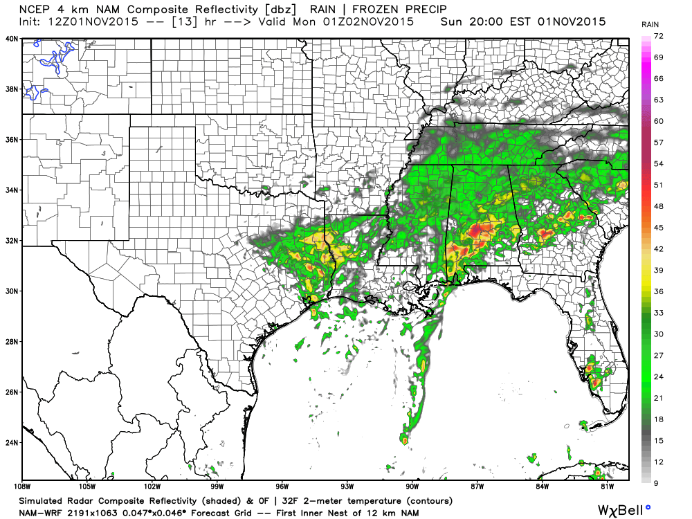
Any showers that form should end by Monday morning. Light rainfall totals, if this occurs at all. The track of the low will be key to the showers spreading this far north and west. Any shift in the low would shift the rain area. Similar to many of our winter type storms.
The amazing news for this week is that we should hit 70+ degrees Monday through Friday. Some question on Friday. We might have more clouds and precipitation on Friday, thus not quite as warm. Stunning November weather. Very unusual to have a pattern like this. Even more unusual not to have it accompanied by thunderstorms. But, the forecast is dry until Thursday night and Friday.
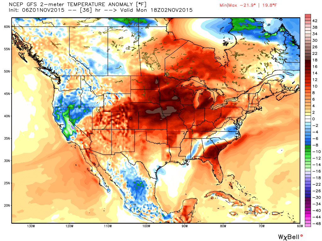
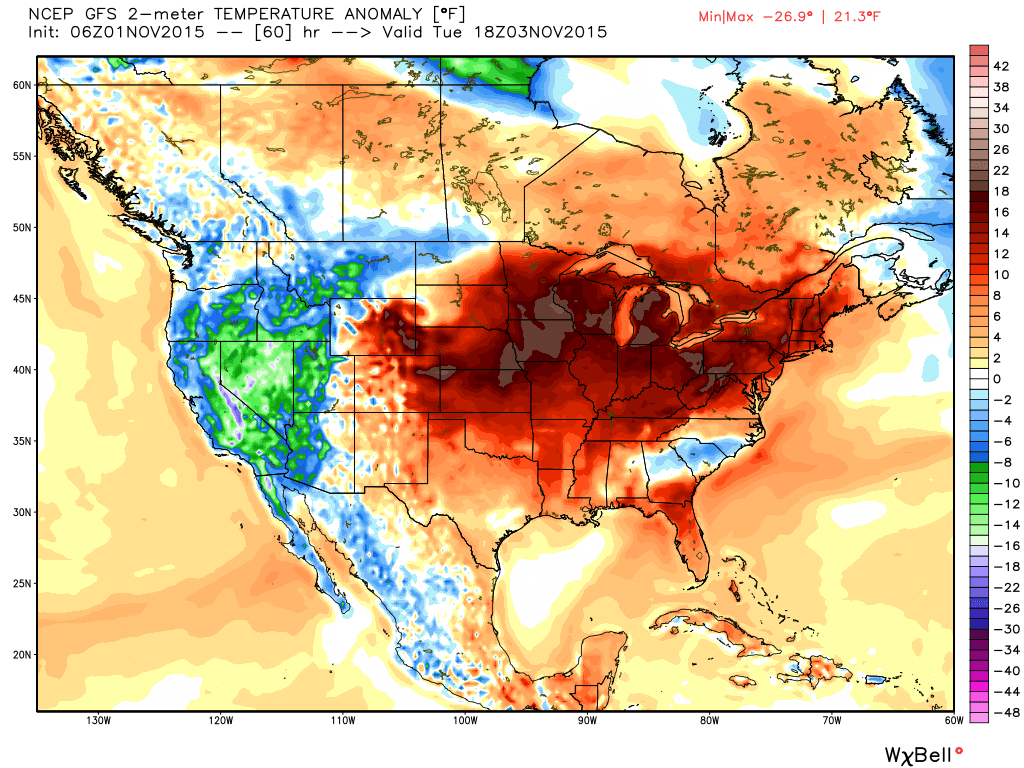
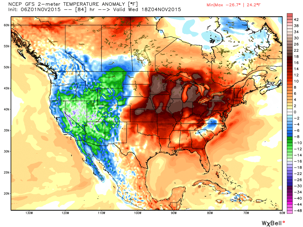
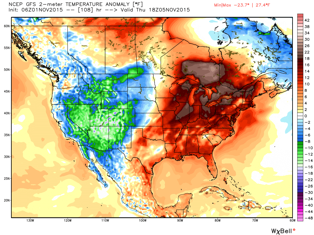
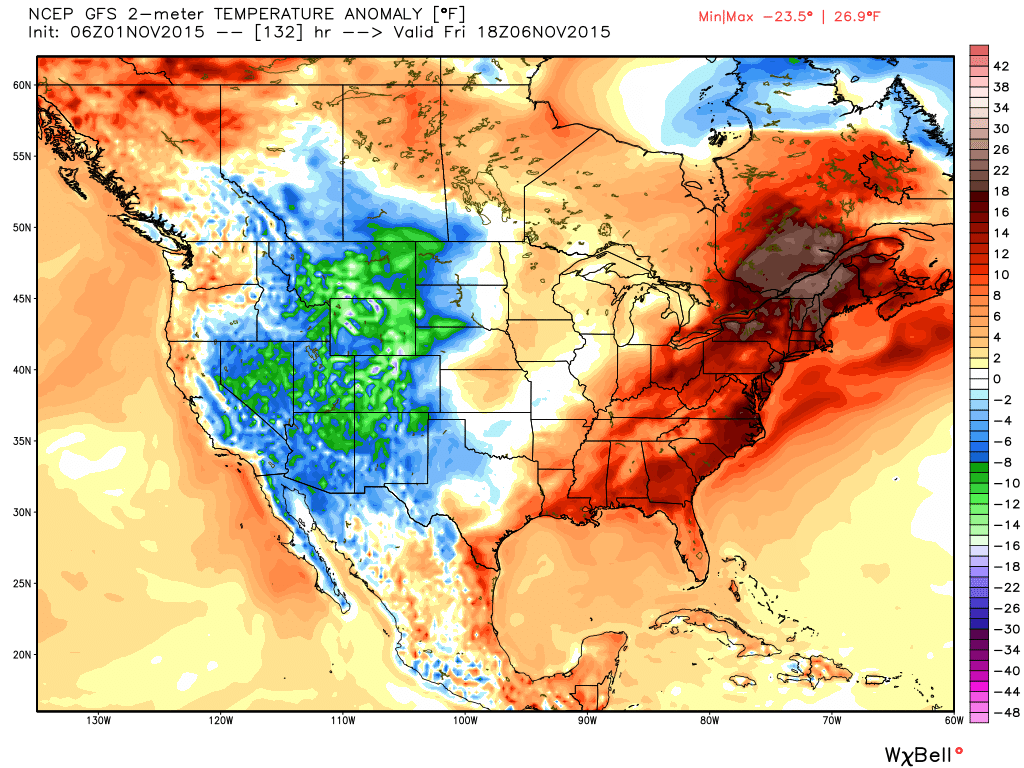
Check out these temperature anomaly maps from weatherbell.com These maps show you how much above or below normal temperatures should be. These are some amazing numbers for November. Well above normal. The red and dark red indicates that.
This first map is for Monday (scale is on the right). Click image for a larger view.
Tuesday
Wednesday
Thursday
Friday
On Thursday night a cold front approaches from the west. This system should spread showers and thunderstorms into our region. A bit early to know if some of the storms would be on the heavy side. I will monitor that part of the forecast.
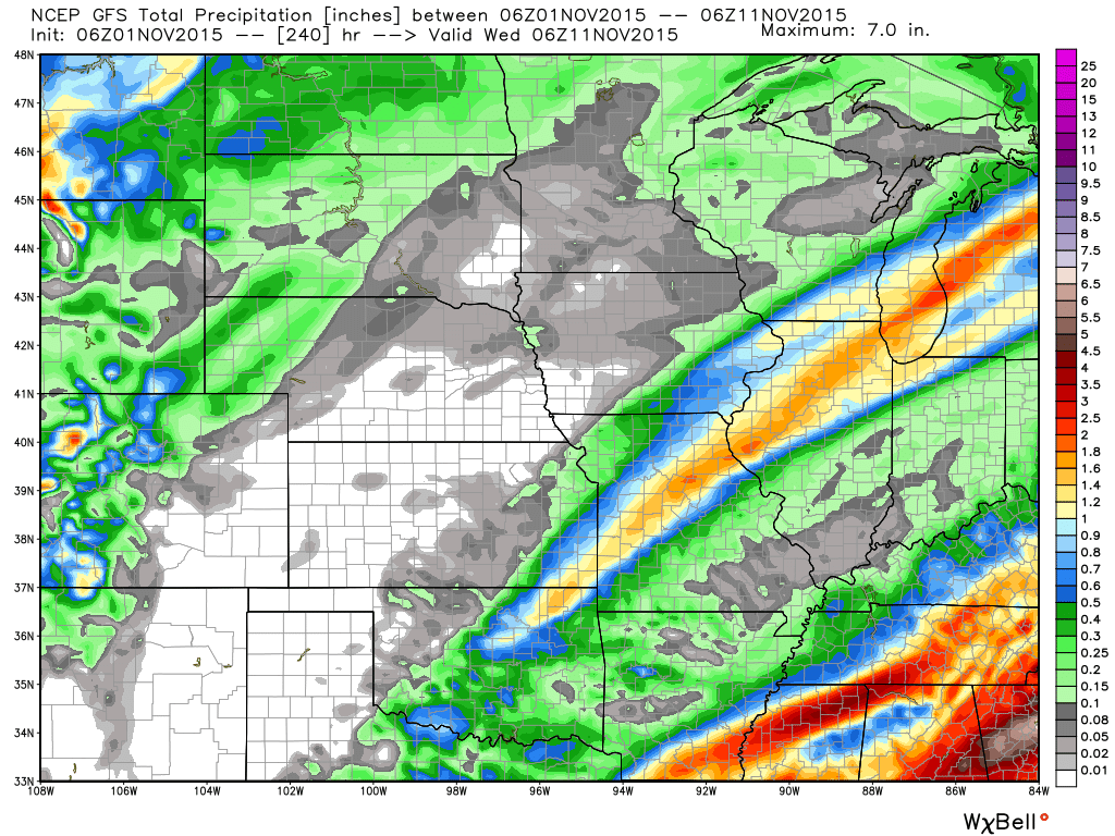
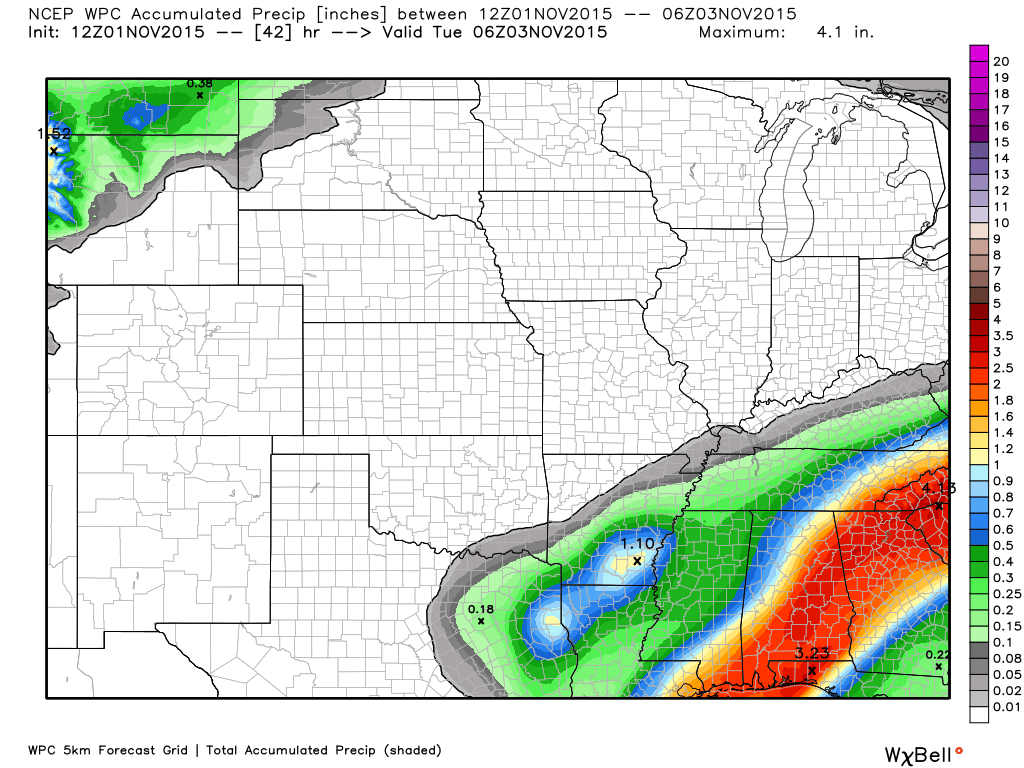
Drought concerns continue. We need a lot more rain. Look at the GFS rainfall totals for the next 10 days. This is bad news, if true.
Then we will cool down over the week. Back to more seasonable temperatures.
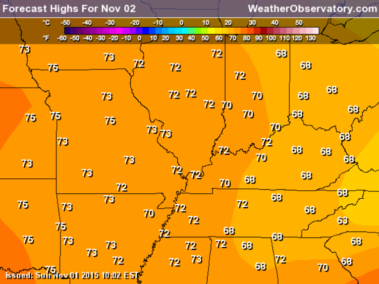
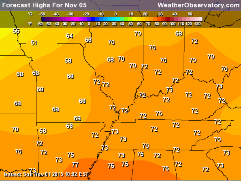
Monday high temperatures
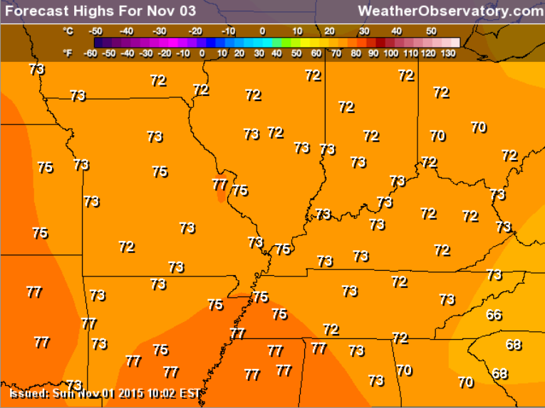
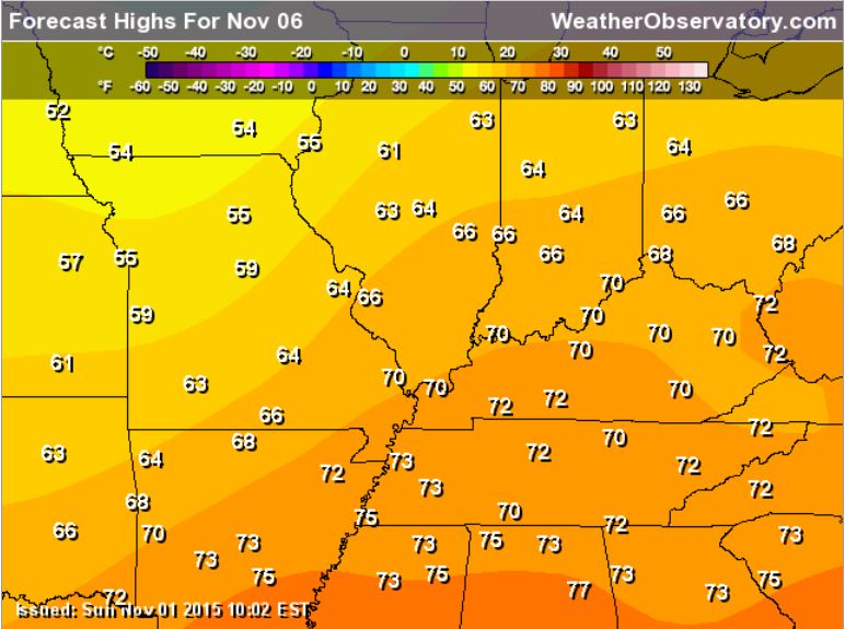
Tuesday high temperatures
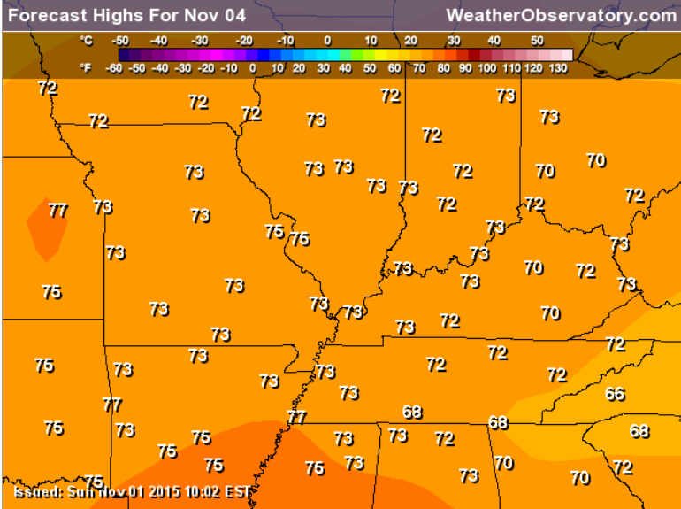
Wednesday high temperatures
Thursday high temperatures
Friday high temperatures
Don’t forget we have interactive city view radars
WEATHER RADAR PAGE – Click here —
First map is the radar animation. You can watch the showers moving through the area.


No significant changes to this outlook.

No concerns through at least Wednesday. Warm weather.

No action for most of us. Maybe a couple of showers late tonight into Monday morning over our far south and southeastern counties.

The wild card for the week ahead will be just how warm will it be. I can’t rule out middle 70s. Believe the chances for upper 70s are fairly small, but not impossible. A very warm week ahead. November? Is that you.

Perhaps around Sunday, November 8th or Monday the 9th. Most of this new week will feel like spring.

How much precipitation should we expect over the next few days?
We have a system approach from the south on Sunday night and Monday morning. This should spread a few showers into our southern and southeastern counties. The further south and east you travel the better chance of rain. That would include perhaps the Kentucky/Tennessee border counties and then south and east from there. Land Between the Lakes perhaps a few showers.
I will monitor the track of the low. It it were to shift 30-40 miles northwest then rain would spread a bit further into western Kentucky.
Showers would be on the light side.
Officially this is the rainfall forecast from the WPC
You can see they brush light amounts into our region. Image is from weatherbell.com

Can we expect severe thunderstorms over the next 24 to 48 hours? Remember that a severe thunderstorm is defined as a thunderstorm that produces 58 mph winds or higher, quarter size hail or larger, and/or a tornado.
Thunderstorm threat level will be ZERO for Monday-Wednesday.
.
Monday: Severe weather is not anticipated.
Tuesday: Severe weather is not anticipated.
Wednesday: Severe weather is not anticipated.
Thursday: Monitor updates.
Friday: Monitor updates
Saturday: Severe weather is not anticipated
Sunday: Severe weather is not anticipated.


I also set up a storm tracking page with additional links (use during active weather for quick reference)
Storm Tracking Tool Page
Let’s take a look at some winter data. I will keep adding to this over the coming weeks.
UPDATE: October 20, 2015: Starting to see a more active pattern the last part of October into the first part of November. A couple of storm systems to monitor. I am noting the southern systems coming through the southwest United States. The thinking is that this winter might end up a southern winter. Meaning, a lot of storm systems will track through the gulf states and then off the southeast coast. If there is blocking then the systems would push up the East Coast. Typically this would be a great track for our region when it comes to winter storms.
The question will be how far south do these systems track. Normally for heavy snow in our region we would look for a system pulling out of Texas and Oklahoma and then tracking into Arkansas, Tennessee, Mississippi, Alabama. That would place our region on the cold side of the area of low pressure.
I do believe this is shaping up to be a fairly unique winter. The warm waters off both coasts are not typical for an El Nino event. Widespread above normal water temperatures in the Pacific and the Atlantic. I will be monitoring Gulf of Mexico water temperatures. Above normal waters in the Gulf of Mexico typically means increased severe thunderstorm activity along the Gulf Coast. It could also mean more moisture for our winter storms to work with.
Drought continues to be the lead story. Our dry pattern has been underway since September and October (for much of the region). The long range cycle typically sets up during October and early November. The longer our calm and dry weather persists the more I am concerned about drought during the winter months.
Precious discussions below.
One of my big concerns is how dry September and October have been over our local counties. This is a concern. I do believe in repeating patterns. Typically October and November set the stage for the winter. Let’s hope we start picking up more precipitation than we have been.
Let me show you some NOAA data. They basically make their winter forecast 100% based on El Nino. Personally I don’t like that approach, but every forecaster has their own method. I believe that every El Nino is unique and is certainly not the only factor in a winter forecast.
With that said here are some typical El Nino graphics
Strong southern jet stream. I agree with that. Potentially dry in our region. I am unsure about that.
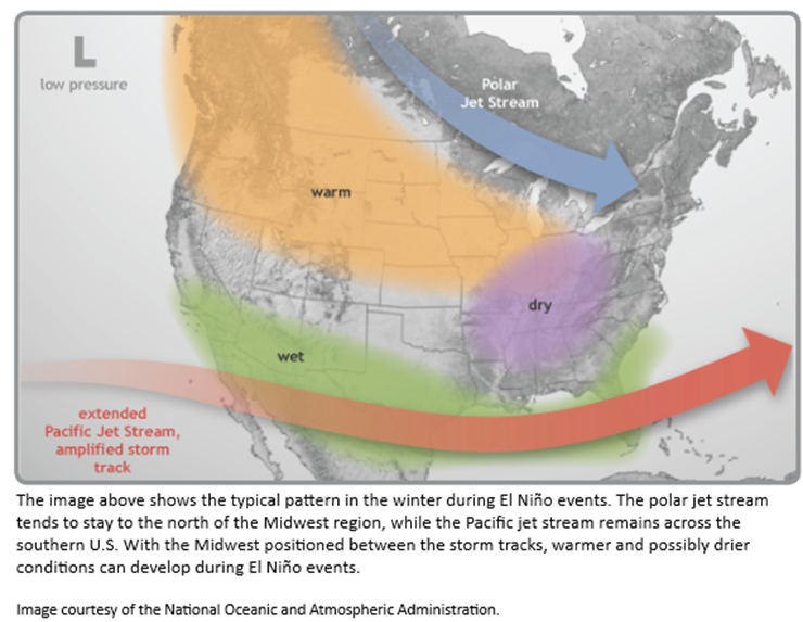
Then there is this map
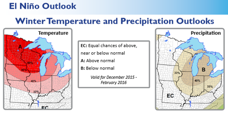
What would a typical El Nino winter look like? Above normal temperatures over the northern United States. Below normal precipitation in and near our region. Again, this is what NOAA puts out.
My thoughts below:
Keep in mind that seasonal forecasts are more for fun than anything else. No meteorologist can forecast details for the winter. Will we have one big snowstorm? Will we have a couple of big snow events? It is the details that you care about. The details can’t be forecast.
However, with that said…meteorologists can forecast some general ideas for an upcoming season.
As you may have read, I am leaning towards a colder than normal winter. But, I am struggling with precipitation. A powerful southern jet stream is forecast for the winter months. We typically have two branches of the jet. A northern branch and a southern brand. That southern branch can produce some nasty weather conditions…including heavy snow, ice, and severe weather.
But, the real question will be the placement of the southern branch in relation to the northern branch. When the two combine you can experience some of your bigger snowstorms.
The models are showing a drier than normal winter for our region. Below normal precipitation. Hopefully this won’t be the case. I don’t like to enter spring in drought. We have already experienced drier than normal conditions over Kentucky and Tennessee over the past month or so. October has been dry, thus far. And, that looks to continue.
Normally we start thinking about severe weather around the third and fourth week of October. Also, we typically have one or two severe weather episodes in November. Too soon to know if that will occur this year.
I am watching a storm system around the 14th-20th.
Back to the winter discussion…
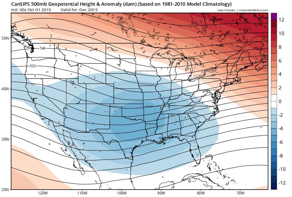
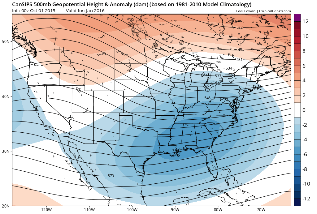
A lot of models are showing below normal temperatures for our region. Let me show you a few charts.
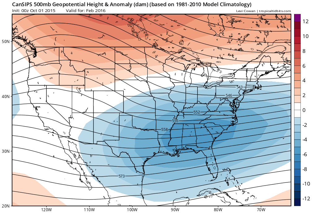
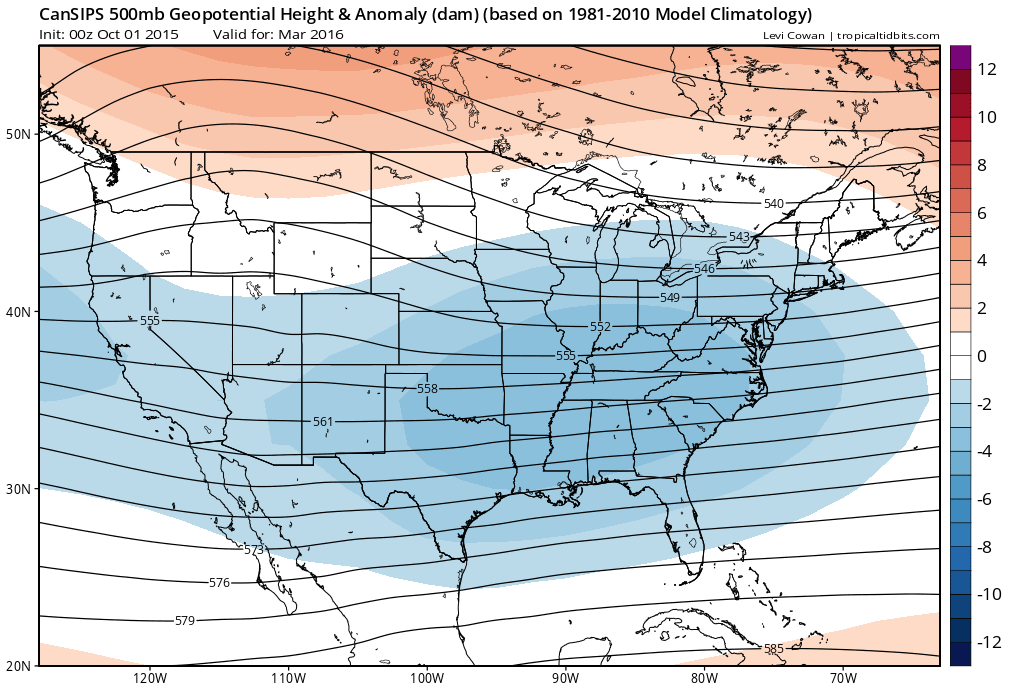
These particular forecast maps are from a Canadian model. Images are from Tropical Tidbits.
This first map is for December. The blue indicates lower than normal 500 mb heights. The red indicates above normal heights. Lot of blue across the southern United States. That could be an indication of stormy weather.
This next map is for January
This next map is for February
This next map is for March
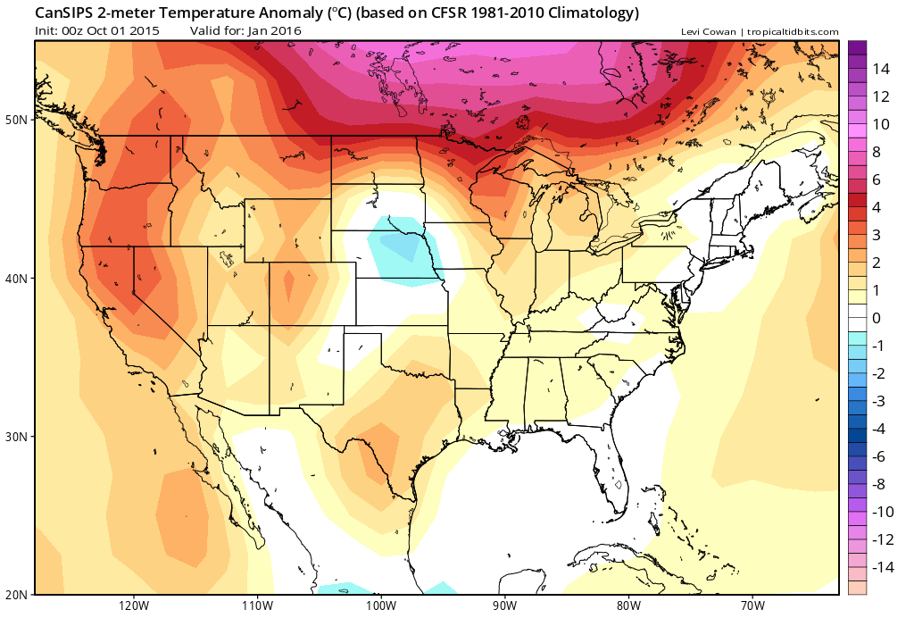
Let’s take a look at temperature anomaly maps
This first map is for December. Blue colors represent below normal temperatures. I am thinking this could be another back loaded winter. Perhaps the harshest winter conditions will be in February and March. Same as last year.

Here is the January temperature anomaly map from this particular model guidance.
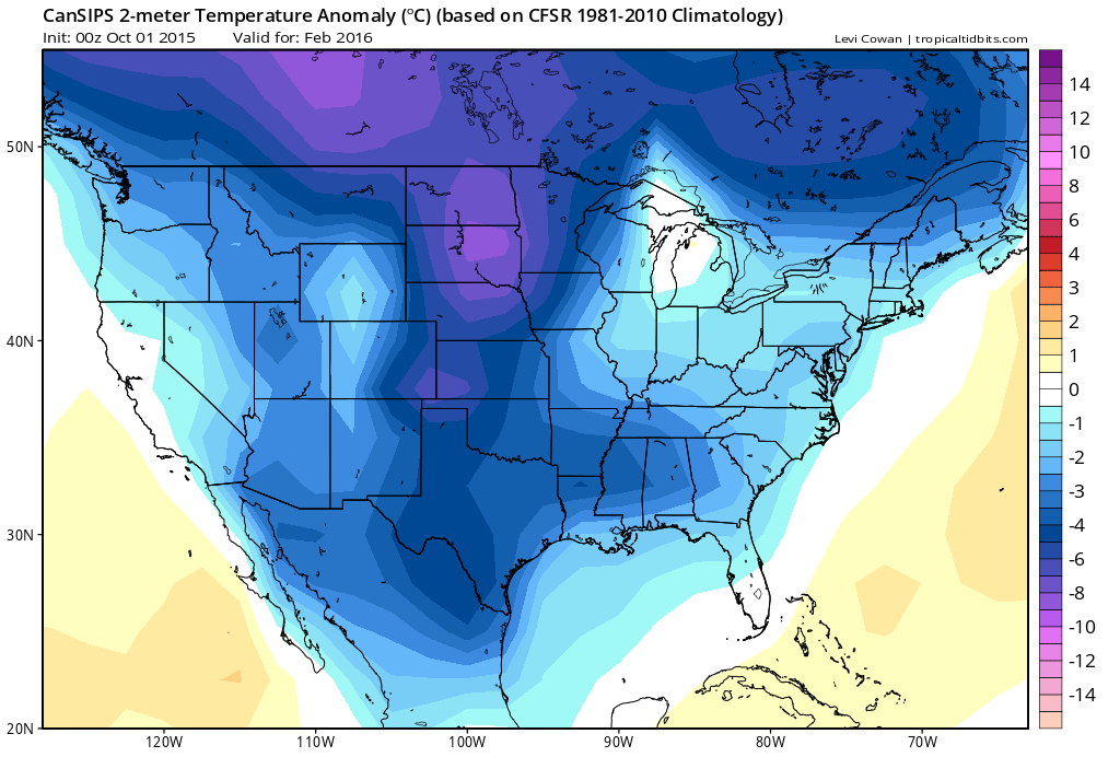
This next map is for February. That is a very cold look for February.
And, let’s take at look at March.

So, what does this mean?
Again, long range forecasting is more for fun than anything else. But, the charts do point towards a cold winter for our region. Perhaps the coldest part of the winter will be February into March. Or, the worst winter conditions will be during that time.
Again, this is just one set of data. There are a lot of other data sets to look over.
I like to move through the Month of October before banking on a winter forecast.
Let’s keep monitoring.
NOAA HAS RELEASED THEIR WINTER FORECAST
NOAA has released their winter forecast. I have been forecasting below normal temperatures for our region. But, I have not banked on precipitation, just yet. The long range cycle is still in the developing stages. The long range cycle typically develops during October and November. It is a repeating pattern that will last through the winter. Until we know what that cycle looks like then making a long range forecast for December into March is difficult, at best.
I am concerned about our dry weather. October has been dry, thus far. Not the best way to start out the next cycle. However, we still have 4-6 more weeks to go. Will the weather become more active during that time period? Frequent cold fronts and frequent precipitation would be a strong clue as to what will happen in December-March.
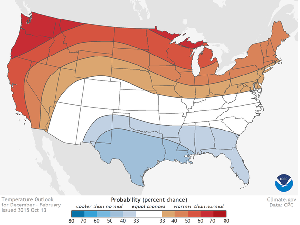
Here is what NOAA said today.
This first map is their temperature outlook. They are forecasting above normal temperatures across the northern United States. In other words, the odds favor above normal temperatures. The blue area, to our south, represents below normal temperatures.
I would have brought the blue further north into our region. It is my forecast opinion that we will have a colder than normal winter. That is when December into early March is averaged out. That does not mean every month will be colder than normal. It simply means the odds favor it averaging out to below normal. We will see how it goes.
I base those ideas off the warm waters off the West Coast of the United States. The last few winters have provided us with a lot of cold air. If the high pressure in Canada shifts into western Canada then we will have plenty of cold air.
Our region is in white. What is NOAA saying about our region? They are saying there is a 50/50 chance for above or below normal temperatures.
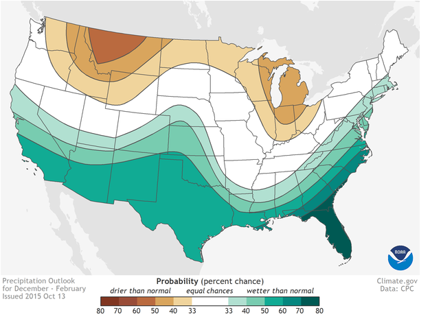
Let’s look at NOAA’s precipitation forecast. They are forecasting the southern United States to have a wetter than normal winter. Drier than normal for much of the northern United States into the Great Lakes. As I have said before, I am not ready to bank on a precipitation outlook.
Our region is in white. What is NOAA forecasting for our region? They are saying a 50/50 chance for above or below normal precipitation.
Remember, forecasters can’t actually tell you what you really want to know. How much snow will fall at my location. Will we have an ice storm. How many winter storms will impact our region. If someone tells you that it is going to snow 8″ on January 15th then take it with a grain of salt. Trust me, no forecaster can accurately forecast specific weather events months in advance. Key word being specific.
We can have a drier than normal winter and a colder than normal winter and still be slammed by one or two big winter storms.
For the most part, our region experiences a couple of winter storms each year. Last year the winter was boring, until it wasn’t. The two big winter storms occurred on February 16th and March 5th. And, many will never forget those two events. November into January was fairly calm.
No matter what winter forecast you read, there isn’t a method of forecasting the big events. The events that matter. Not months in advance, at least. We do well to forecast them a few days in advance, let alone months in advance.
Forecasters do fairly well with general over/under forecasts. Warmer than normal/colder than normal. Wetter than normal/drier than normal. But, that really does not tell the story of winter. That does not tell you what you really are wondering. Thus, is the nature of long range forecasting. Maybe one day it will improve

We have regional radars and local city radars – if a radar does not seem to be updating then try another one. Occasional browsers need their cache cleared. You may also try restarting your browser. That usually fixes the problem. Occasionally we do have a radar go down. That is why I have duplicates. Thus, if one fails then try another one.
If you have any problems then please send me an email beaudodson@usawx.com
WEATHER RADAR PAGE – Click here —
We also have a new national interactive radar – you can view that radar by clicking here.
Local interactive city radars include St Louis, Mt Vernon, Evansville, Poplar Bluff, Cape Girardeau, Marion, Paducah, Hopkinsville, Memphis, Nashville, Dyersburg, and all of eastern Kentucky – these are interactive radars. Local city radars – click here
NOTE: Occasionally you will see ground clutter on the radar (these are false echoes). Normally they show up close to the radar sites – including Paducah.

Regional Radar – Click on radar to take you our full radar page.


Live Lightning Data – zoom and pan: Click here
Live Lightning Data with sound (click the sound button on the left side of the page): Click here
I also set up a storm tracking page with additional links (use during active weather for quick reference)
Storm Tracking Tool Page
![]()
Current WARNINGS (a warning means take action now). Click on your county to drill down to the latest warning information. Keep in mind that there can be a 2-3 minute delay in the updated warning information.
I strongly encourage you to use a NOAA Weather Radio or warning cell phone app for the most up to date warning information. Nothing is faster than a NOAA weather radio.


Color shaded counties are under some type of watch, warning, advisory, or special weather statement. Click your county to view the latest information.

Missouri Warnings

Illinois Warnings

Kentucky Warnings

Here is the official 6-10 day and 8-14 day temperature and precipitation outlook. Check the date stamp at the top of each image (so you understand the time frame).
The forecast maps below are issued by the Weather Prediction Center (NOAA).


The latest 8-14 day temperature and precipitation outlook. Note the dates are at the top of the image. These maps DO NOT tell you how high or low temperatures or precipitation will be. They simply give you the probability as to whether temperatures or precipitation will be above or below normal.


Here are the current river stage forecasts. You can click your state and then the dot for your location. It will bring up the full forecast and hydrograph.
Click Here For River Stage Forecasts…
Here are some current forecast hydrographs. These will be updated each day with new information.


Smithland Lock and Dam

Paducah, Kentucky Forecast Stage

Cairo, Illinois

Cape Girardeau, Missouri

Who do you trust for your weather information and who holds them accountable?
I have studied weather in our region since the late 1970’s. I have 37 years of experience in observing our regions weather patterns. My degree is in Broadcast Meteorology from Mississippi State University and an Associate of Science (AS). I am currently working on my Bachelor’s Degree in Geoscience.
My resume includes:
Member of the American Meteorological Society.
NOAA Weather-Ready Nation Ambassador.
Meteorologist for McCracken County Emergency Management.
I own and operate the Southern Illinois Weather Observatory.
Recipient of the Mark Trail Award, WPSD Six Who Make A Difference Award, Kentucky Colonel, and the Caesar J. Fiamma” Award from the American Red Cross.
In 2009 I was presented with the Kentucky Office of Highway Safety Award.
Recognized by the Kentucky House of Representatives for my service to the State of Kentucky leading up to several winter storms and severe weather outbreaks.
I am also President of the Shadow Angel Foundation which serves portions of western Kentucky and southern Illinois.
There is a lot of noise on the internet. A lot of weather maps are posted without explanation. Over time you should learn who to trust for your weather information.
My forecast philosophy is simple and straight forward.
- Communicate in simple terms
- To be as accurate as possible within a reasonable time frame before an event
- Interact with you on Twitter, Facebook, and the blog
- Minimize the “hype” that you might see on television or through other weather sources
- Push you towards utilizing wall-to-wall LOCAL TV coverage during severe weather events
I am a recipient of the Mark Trail Award, WPSD Six Who Make A Difference Award, Kentucky Colonel, and the Caesar J. Fiamma” Award from the American Red Cross. In 2009 I was presented with the Kentucky Office of Highway Safety Award. I was recognized by the Kentucky House of Representatives for my service to the State of Kentucky leading up to several winter storms and severe weather outbreaks.
If you click on the image below you can read the Kentucky House of Representatives Resolution.

Many of my graphics are from www.weatherbell.com – a great resource for weather data, model data, and more


You can sign up for my AWARE email by clicking here I typically send out AWARE emails before severe weather, winter storms, or other active weather situations. I do not email watches or warnings. The emails are a basic “heads up” concerning incoming weather conditions.