Looking for a holiday present for your loved ones?
How about a WeatherTalk subscription! Help keep them aware of changing weather conditions.

![]()

November 17, 2018
Saturday forecast: Mostly sunny. Somewhat milder.
Temperatures: MO ~ 50 to 60 IL ~ 48 to 58 KY ~ 54 to 58 TN ~ 56 to 58
What is the chance of precipitation? MO ~ 0% IL ~ 0% KY ~ 0% TN ~ 0%
Coverage of precipitation: None
Is snow or ice anticipated? No
Wind: West and southwest at 5 to 10 mph
What impacts are anticipated from the weather? None
My confidence in the forecast verifying: High
Is severe weather expected? No
The NWS defines severe weather as 58 mph wind or great, 1″ hail or larger, and/or tornadoes
Should I cancel my outdoor plans? No
UV Index: 3 to 5 Moderate
Sunrise: 6:35 AM
Saturday Night Forecast Details:
Forecast: Clouds. Breezy and colder. Isolated light rain showers possible.
Temperatures: MO ~ 34 to 36 IL ~ 34 to 36 KY ~ 36 to 38 TN ~ 36 to 40
What is the chance of precipitation? MO ~ 30% IL ~ 30% KY ~ 20% TN ~ 10%
Coverage of precipitation: Spotty
Is snow or ice anticipated? No
Wind: North and northeast at 5 to 10 mph
What impacts are anticipated from the weather? Isolated wet roadways
My confidence in the forecast verifying: High
Is severe weather expected? No
The NWS defines severe weather as 58 mph wind or great, 1″ hail or larger, and/or tornadoes
Should I cancel my outdoor plans? No
Sunset: 4:44 PM
Moonrise: 1:30 PM Waxing Gibbous
Moonset: 12:01 AM
November 18, 2018
Sunday forecast: Cloudy. A light shower possible. Below normal temperatures. Shower chances increasing PM hours vs AM.
Temperatures: MO ~ 40 to 48 IL ~ 42 to 48 KY ~46 to 52 TN ~ 48 to 54
What is the chance of precipitation? MO ~ 40% IL ~ 40% KY ~ 30% to 40% PM TN ~ 30% to 40% PM
Coverage of precipitation: Scattered
Is snow or ice anticipated? No
Wind: North at 4 to 8 mph
What impacts are anticipated from the weather? Wet roadways.
My confidence in the forecast verifying: High
Is severe weather expected? No
The NWS defines severe weather as 58 mph wind or great, 1″ hail or larger, and/or tornadoes
Should I cancel my outdoor plans? No
UV Index: 2 to 3 Low
Sunrise: 6:38 AM
Sunday Night Forecast Details:
Forecast: Cloudy. Cold. Rain showers likely.
Temperatures: MO ~ 34 to 38 IL ~ 34 to 38 KY ~ 35 to 40 TN ~ 35 to 40
What is the chance of precipitation? MO ~ 60% IL ~ 60% KY ~ 60% TN ~ 60%
Coverage of precipitation: Scattered
Is snow or ice anticipated? Unlikely
Wind: North wind 5 to 10 mph
What impacts are anticipated from the weather? Wet roadways.
My confidence in the forecast verifying: Medium
Is severe weather expected? No
The NWS defines severe weather as 58 mph wind or great, 1″ hail or larger, and/or tornadoes
Should I cancel my outdoor plans? Monitor radars
Sunset: 4:42 PM
Moonrise: 2:30 PM Waxing Gibbous
Moonset: 1:39 AM
November 19, 2018
Monday forecast: Decreasing clouds. An early morning shower possible over our eastern counties (Pennyrile area of western Kentucky). Cold.
Temperatures: MO ~ 44 to 48 IL ~ 44 to 48 KY ~ 44 to 48 TN ~ 44 to 48
What is the chance of precipitation? MO ~ 0% IL ~ 0% KY ~ 20% TN ~ 20%
Coverage of precipitation: Spotty early in the day.
Is snow or ice anticipated? No
Wind: North 5 to 10 mph becoming west at 5 to 10
What impacts are anticipated from the weather? A few morning wet roadways
My confidence in the forecast verifying: Medium
Is severe weather expected? No
The NWS defines severe weather as 58 mph wind or great, 1″ hail or larger, and/or tornadoes
Should I cancel my outdoor plans? No
UV Index: 4 to 5 Moderate
Sunrise: 6:39 AM
Monday Night Forecast Details:
Forecast: Mostly clear. Cold.
Temperatures: MO ~ 26 to 28 IL ~ 26 to 30 KY ~ 30 to 34 TN ~ 32 to 34
What is the chance of precipitation? MO ~ 0% IL ~ 0% KY ~ 0% TN ~ 0%
Coverage of precipitation: None
Is snow or ice anticipated? No
Wind: West and northwest at 5 to 10 mph
What impacts are anticipated from the weather? None
My confidence in the forecast verifying: High
Is severe weather expected? No
The NWS defines severe weather as 58 mph wind or great, 1″ hail or larger, and/or tornadoes
Should I cancel my outdoor plans? No
Sunset: 4:42 PM
Moonrise: 3:00 PM Waxing Gibbous
Moonset: 2:39 AM
November 20, 2018
Tuesday forecast: Mostly sunny. Cool. Below normal temperatures.
Temperatures: MO ~ 44 to 48 IL ~ 44 to 48 KY ~ 46 to 48 TN ~ 48 to 52
What is the chance of precipitation? MO ~ 0% IL ~ 0% KY ~ 0% TN ~ 0%
Coverage of precipitation: None
Is snow or ice anticipated? No
Wind: North and northwest at 4 to 8 mph
What impacts are anticipated from the weather? None
My confidence in the forecast verifying: High
Is severe weather expected? No
The NWS defines severe weather as 58 mph wind or great, 1″ hail or larger, and/or tornadoes
Should I cancel my outdoor plans? No
UV Index: 4 to 5 Moderate
Sunrise: 6:40 AM
Tuesday Night Forecast Details:
Forecast: Mostly clear. Cold.
Temperatures: MO ~ 26 to 28 IL ~ 26 to 28 KY ~ 30 to 35 TN ~ 32 to 36
What is the chance of precipitation? MO ~ 0% IL ~ 0% KY ~ 0% TN ~ 0%
Coverage of precipitation: None
Is snow or ice anticipated? No
Wind: Variable at 5 mph
What impacts are anticipated from the weather? None
My confidence in the forecast verifying: High
Is severe weather expected? No
The NWS defines severe weather as 58 mph wind or great, 1″ hail or larger, and/or tornadoes
Should I cancel my outdoor plans? No
Sunset: 4:41 PM
Moonrise: 3:31 PM Waxing Gibbous
Moonset: 3:39 AM
November 21, 2018
Wednesday forecast: Mostly sunny. Cool. Below normal temperatures.
Temperatures: MO ~ 50 to 54 IL ~ 48 to 54 KY ~ 50 to 55 TN ~ 50 to 55
What is the chance of precipitation? MO ~ 0% IL ~ 0% KY ~ 0% TN ~ 0%
Coverage of precipitation: None
Is snow or ice anticipated? No
Wind: Variable at 4 to 8 mph
What impacts are anticipated from the weather? None
My confidence in the forecast verifying: High
Is severe weather expected? No
The NWS defines severe weather as 58 mph wind or great, 1″ hail or larger, and/or tornadoes
Should I cancel my outdoor plans? No
UV Index: 4 to 5 Moderate
Sunrise: 6:41 AM
Wednesday Night Forecast Details:
Forecast: Mostly clear. Cold.
Temperatures: MO ~ 28 to 34 IL ~ 28 to 34 KY ~ 30 to 35 TN ~ 30 to 35
What is the chance of precipitation? MO ~ 0% IL ~ 0% KY ~ 0% TN ~ 0%
Coverage of precipitation: None
Is snow or ice anticipated? No
Wind: South and southeast at 4 to 8 mph
What impacts are anticipated from the weather? None
My confidence in the forecast verifying: High
Is severe weather expected? No
The NWS defines severe weather as 58 mph wind or great, 1″ hail or larger, and/or tornadoes
Should I cancel my outdoor plans? No
Sunset: 4:41 PM
Moonrise: 4:04 PM Waxing Gibbous
Moonset: 4:42 AM
November 22, 2018
Thanksgiving
Thursday forecast: Mostly sunny. A bit milder.
Temperatures: MO ~ 52 to 56 IL ~ 52 to 56 KY ~ 52 to 56 TN ~ 52 to 56
What is the chance of precipitation? MO ~ 0% IL ~ 0% KY ~ 0% TN ~ 0%
Coverage of precipitation: None
Is snow or ice anticipated? No
Wind: Southeast at 5 to 10 mph
What impacts are anticipated from the weather? None
My confidence in the forecast verifying: High
Is severe weather expected? No
The NWS defines severe weather as 58 mph wind or great, 1″ hail or larger, and/or tornadoes
Should I cancel my outdoor plans? No
UV Index: 4 to 5 Moderate
Sunrise: 6:42 AM
Thursday Night Forecast Details:
Forecast: Partly cloudy. Chilly.
Temperatures: MO ~ 36 to 40 IL ~ 36 to 40 KY ~ 36 to 40 TN ~ 36 to 40
What is the chance of precipitation? MO ~ 0% IL ~ 0% KY ~ 0% TN ~ 0%
Coverage of precipitation: None
Is snow or ice anticipated? No
Wind:
What impacts are anticipated from the weather? None
My confidence in the forecast verifying: Medium
Is severe weather expected? No
The NWS defines severe weather as 58 mph wind or great, 1″ hail or larger, and/or tornadoes
Should I cancel my outdoor plans? No
Sunset: 4:40 PM
Moonrise: 4:43 PM Full
Moonset: 5:48 AM
November 23, 2018
Friday forecast: Becoming cloudy. A chance of showers.
Temperatures: MO ~ 52 to 56 IL ~ 52 to 56 KY ~ 52 to 56 TN ~ 52 to 56
What is the chance of precipitation? MO ~ 30% IL ~ 30% KY ~ 30% TN ~ 30%
Coverage of precipitation: Scattered
Is snow or ice anticipated? No
Wind: Southeast at 5 to 10 mph
What impacts are anticipated from the weather? Wet roadways
My confidence in the forecast verifying: Medium
Is severe weather expected? No
The NWS defines severe weather as 58 mph wind or great, 1″ hail or larger, and/or tornadoes
Should I cancel my outdoor plans? Monitor updates. Some rain will be possible.
UV Index: 2 to 3 Low
Sunrise: 6:43 AM
Friday Night Forecast Details:
Forecast: Cloudy with a chance of showers.
Temperatures: MO ~ 44 to 48 IL ~ 44 to 48 KY ~ 44 to 48 TN ~ 44 to 48
What is the chance of precipitation? MO ~ 30% IL ~ 30% KY ~ 30% TN ~ 30%
Coverage of precipitation: Scattered
Is snow or ice anticipated? No
Wind: South at 5 to 10 mph
What impacts are anticipated from the weather? Wet roadways
My confidence in the forecast verifying: LOW
Is severe weather expected? No
The NWS defines severe weather as 58 mph wind or great, 1″ hail or larger, and/or tornadoes
Should I cancel my outdoor plans? Monitor updates. Some rain will be possible.
Sunset: 4:40 PM
Moonrise: 5:27 PM Waning Gibbous
Moonset: 6:55 AM
November 24, 2018
Saturday forecast: Cloudy. A chance of showers.
Temperatures: MO ~ 52 to 56 IL ~ 52 to 56 KY ~ 52 to 56 TN ~ 52 to 56
What is the chance of precipitation? MO ~ 30% IL ~ 30% KY ~ 30% TN ~ 30%
Coverage of precipitation: Scattered
Is snow or ice anticipated? No
Wind: Southeast at 5 to 10 mph
What impacts are anticipated from the weather? Wet roadways
My confidence in the forecast verifying: LOW
Is severe weather expected? No
The NWS defines severe weather as 58 mph wind or great, 1″ hail or larger, and/or tornadoes
Should I cancel my outdoor plans? Monitor updates. Some rain will be possible.
UV Index: 1 to 2 Low
Sunrise: 6:44 AM
Saturday Night Forecast Details:
Forecast: Cloudy with a chance of showers.
Temperatures: MO ~ 44 to 48 IL ~ 44 to 48 KY ~ 44 to 48 TN ~ 44 to 48
What is the chance of precipitation? MO ~ 30% IL ~ 30% KY ~ 30% TN ~ 30%
Coverage of precipitation: Scattered
Is snow or ice anticipated? No
Wind: South at 5 to 10 mph
What impacts are anticipated from the weather? Wet roadways
My confidence in the forecast verifying: LOW
Is severe weather expected? No
The NWS defines severe weather as 58 mph wind or great, 1″ hail or larger, and/or tornadoes
Should I cancel my outdoor plans? Monitor updates. Some rain will be possible.
Sunset: 4:39 PM
Moonrise: 6:17 PM Waning Gibbous
Moonset: 8:02 AM
November 25, 2018
Sunday forecast: Cloudy. A chance of showers.
Temperatures: MO ~ 52 to 56 IL ~ 52 to 56 KY ~ 52 to 56 TN ~ 52 to 56
What is the chance of precipitation? MO ~ 30% IL ~ 30% KY ~ 30% TN ~ 30%
Coverage of precipitation: Scattered
Is snow or ice anticipated? No
Wind: Southeast at 5 to 10 mph
What impacts are anticipated from the weather? Wet roadways
My confidence in the forecast verifying: LOW
Is severe weather expected? No
The NWS defines severe weather as 58 mph wind or great, 1″ hail or larger, and/or tornadoes
Should I cancel my outdoor plans? Monitor updates. Some rain will be possible.
UV Index: 1 to 2 Low
Sunrise: 6:45 AM
Sunday Night Forecast Details:
Forecast: Partly cloudy. Cool.
Temperatures: MO ~ 35 to 40 IL ~ 35 to 40 KY ~ 35 to 40 TN ~ 35 to 40
What is the chance of precipitation? MO ~ 30% IL ~ 30% KY ~ 30% TN ~ 30%
Coverage of precipitation: None
Is snow or ice anticipated? No
Wind: Northwest at 5 mph
What impacts are anticipated from the weather? None
My confidence in the forecast verifying: LOW
Is severe weather expected? No
The NWS defines severe weather as 58 mph wind or great, 1″ hail or larger, and/or tornadoes
Should I cancel my outdoor plans? No
Sunset: 4:39 PM
Moonrise: 7:14 PM Waning Gibbous
Moonset: 9:08 AM

Today through Monday: No significant winter weather.
The Weather Observatory will be holding two open houses for adults and children. Weather permitting, the open house will be Saturday, December 1st.
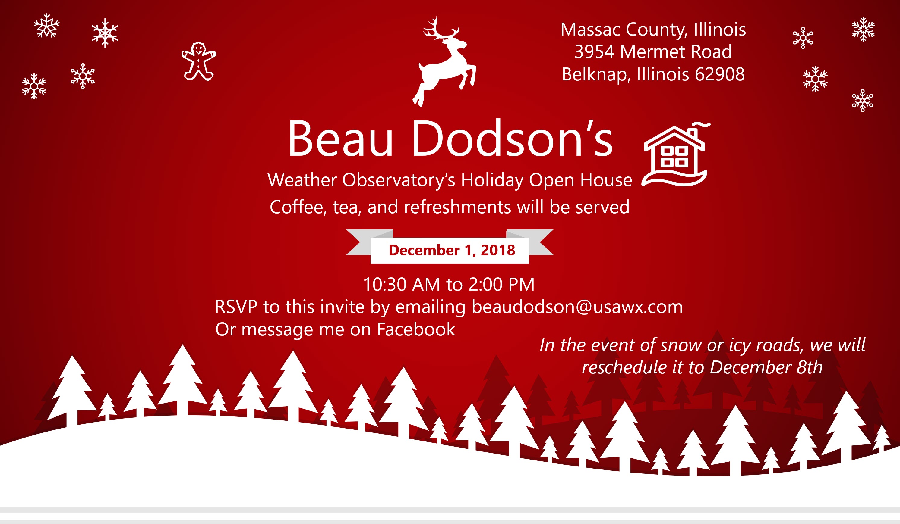
Class of 1988 (Massac County High School). I will be having a special open house for you on Friday, November 30th (the night before the other open house)

Learn more about the UV index readings. Click here.

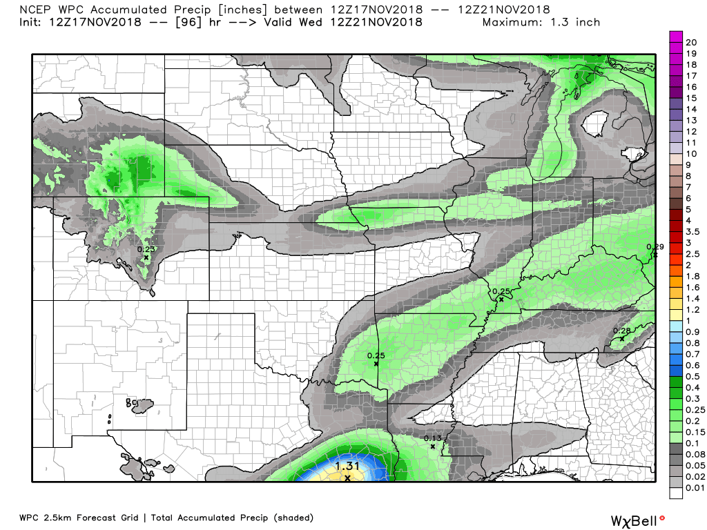
Here is the WPC/NOAA rainfall outlook
No significant precipitation over the next seven days.
Some shower chances Sunday/Sunday night. Rain should end by Monday morning.
Light totals.

Subscribers, do you need a forecast for an outdoor event?


We offer interactive local city live radars and regional radars.
If a radar does not update then try another one. If a radar does not appear to be refreshing then hit Ctrl F5 on your keyboard.
You may also try restarting your browser. The local city view radars also have clickable warnings.
During the winter months, you can track snow and ice by clicking the winterize button on the local city view interactive radars.

Questions? Broken links? Other questions?
You may email me at beaudodson@usawx.com

The National Weather Service defines a severe thunderstorm as one that produces quarter size hail or larger, 58 mph winds or greater, and/or a tornado.
Today through next Saturday: No severe storms.
Interactive live weather radar page. Choose the city nearest your location. If one of the cities does not work then try a nearby one. Click here.
National map of weather watches and warnings. Click here.
Storm Prediction Center. Click here.
Weather Prediction Center. Click here.

Live lightning data: Click here.

Interactive GOES R satellite. Track clouds. Click here.

Here are the latest local river stage forecast numbers Click Here.
Here are the latest lake stage forecast numbers for Kentucky Lake and Lake Barkley Click Here.

- Just a quick weekend update
- Milder today. Enjoy.
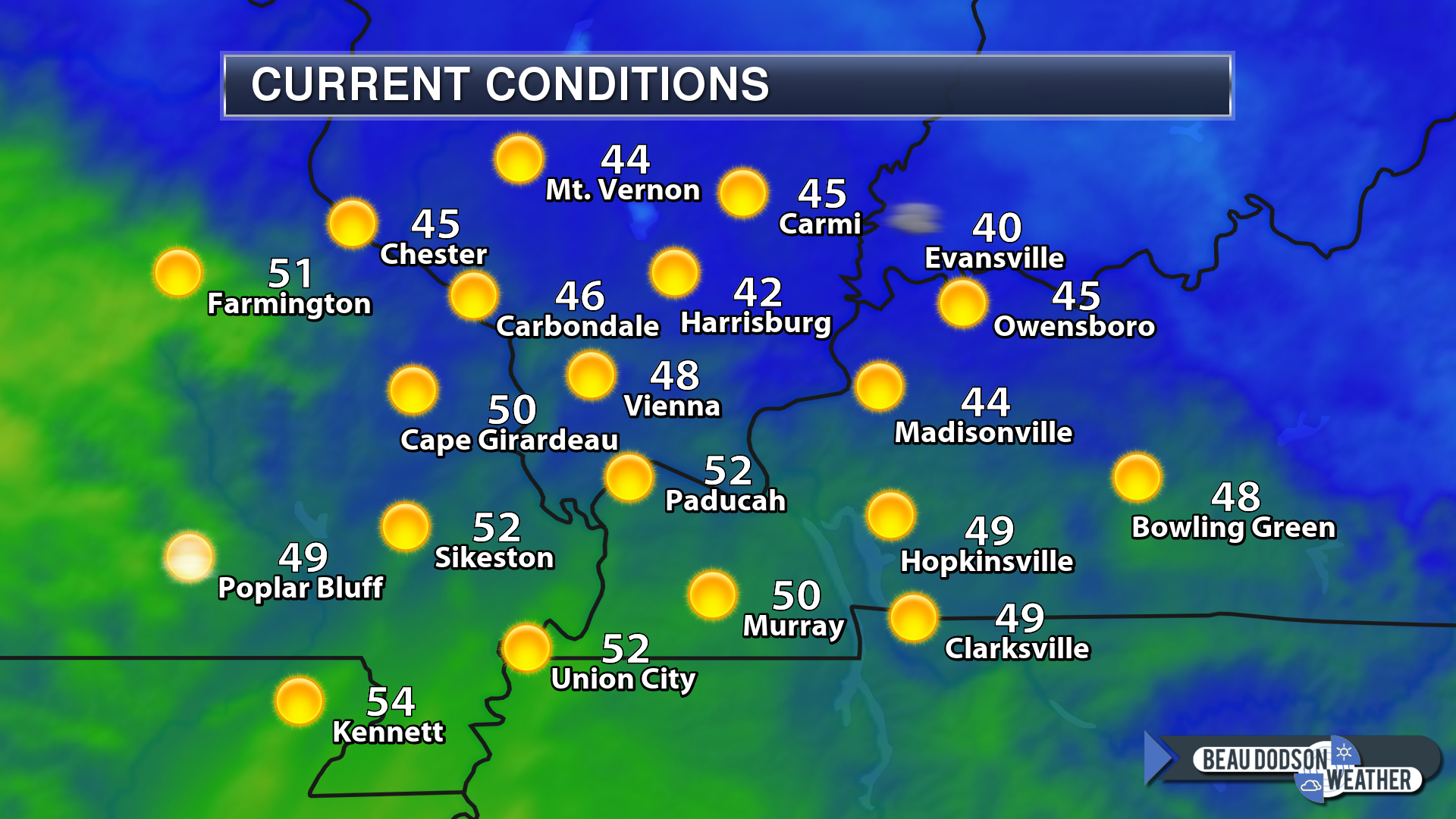
Temperatures this morning aren’t all that bad. Cool, but not as cold as some of our recent nights.
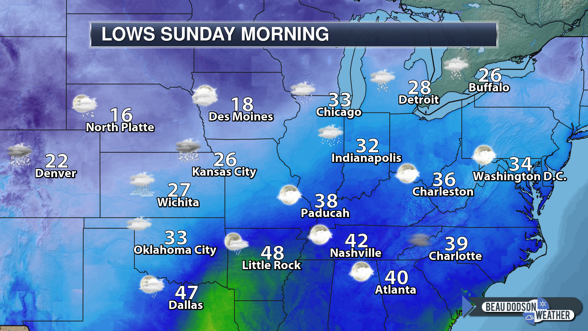
Here were the 10 AM temperatures
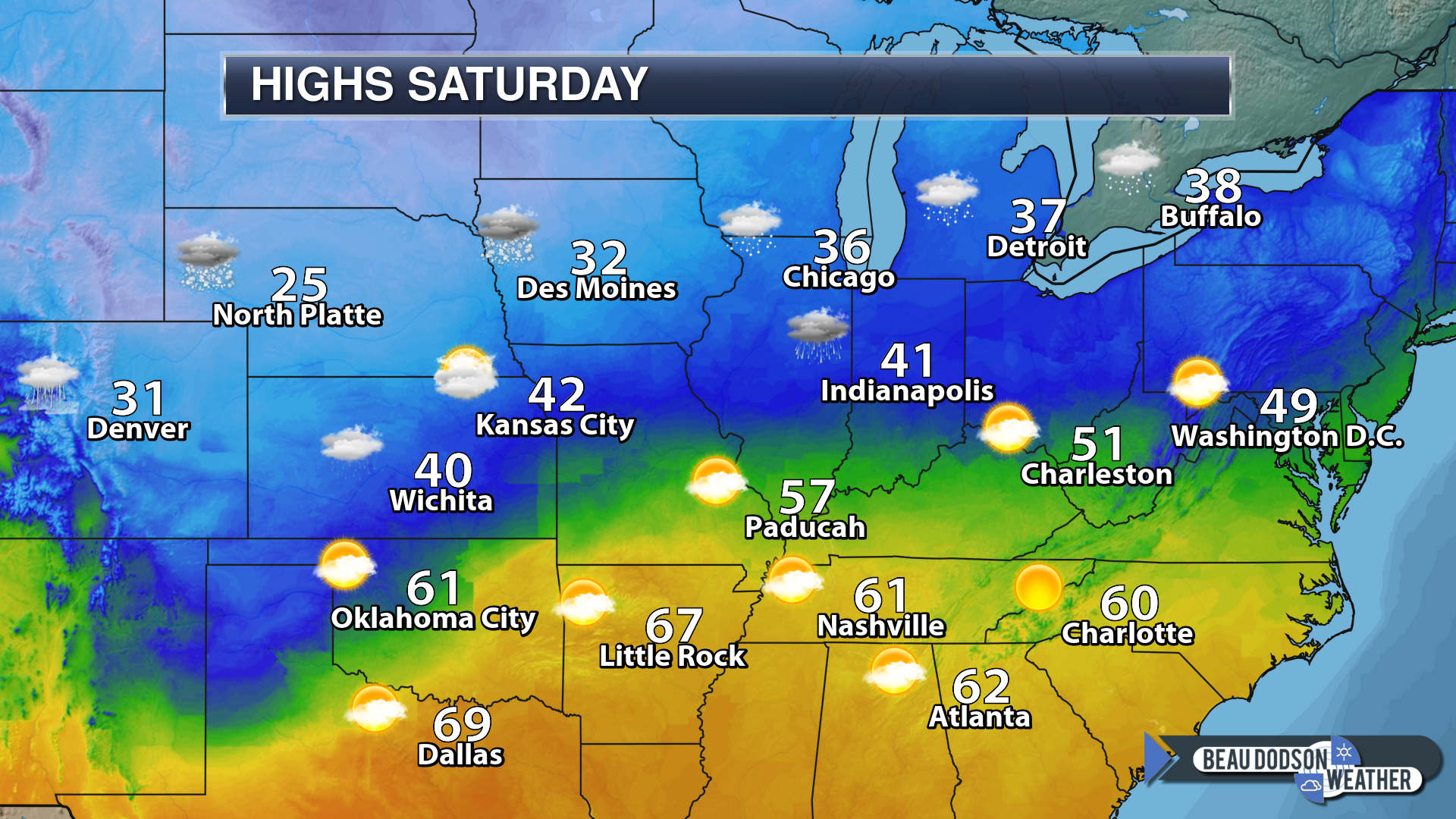
Today’s highs
Tonight’s lows
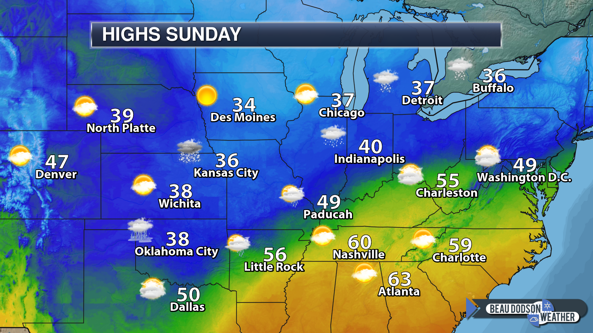
Sunday’s highs
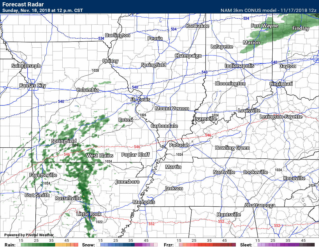
Future-cast radar. The time-stamp is in the upper left portion of the animation. This takes us from Sunday morning into Monday morning.
Green represents rain showers.
Thanksgiving
At this time, no significant weather is anticipated Wednesday, Thursday, or Friday.
I am monitoring rain chances Friday or Saturday. This does not look to be a big deal.
A second system may impact the region on Sunday. At this time, it appears this would be a rain event. Perhaps some thunderstorms. Confidence this far out is low.
![]()

A new weather podcast is now available! Weather Geeks (which you might remember is on The Weather Channel each Sunday)
To learn more visit their website. Click here.
![]()

WeatherBrains Episode 669
Tonight’s Guest WeatherBrain is a CFM who started working for the City of Austin, TX’s Watershed Protection Department as an intern in 1998, and joined the Flood Early Warning System (FEWS) team in 2006. He serves as the Senior Systems Administrator, which is responsible for maintaining all IT hardware and software associated with FEWS. He is also an on-call responder for flood events in Austin. Working with Code for America, Matthew created AtxFloods.com in 2012. Matthew Porcher, welcome to WeatherBrains!
Other discussions in this weekly podcast include topics like:
- Trace of snowfall at Wichita Falls, Texas
- 9.5 inches of snow in parts of Texas Panhandle
- Continued discussion on social media
- Over 5 inches of rainfall in parts of East Alabama
- Astronomy Outlook with Tony Rice
- and more!
Link to their website https://weatherbrains.com/
Previous episodes can be viewed by clicking here.

We offer interactive local city live radars and regional radars. If a radar does not update then try another one. If a radar does not appear to be refreshing then hit Ctrl F5. You may also try restarting your browser.
The local city view radars also have clickable warnings.
During the winter months, you can track snow and ice by clicking the winterize button on the local city view interactive radars.
You may email me at beaudodson@usawx.com
Find me on Facebook!

Find me on Twitter!

Did you know that a portion of your monthly subscription helps support local charity projects?
You can learn more about those projects by visiting the Shadow Angel Foundation website and the Beau Dodson News website.

I encourage subscribers to use the app vs regular text messaging. We have found text messaging to be delayed during severe weather. The app typically will receive the messages instantly. I recommend people have three to four methods of receiving their severe weather information.
Remember, my app and text alerts are hand typed and not computer generated. You are being given personal attention during significant weather events.
