WeatherTalk monthly operating costs can top $2000.00. Your $5 subscription helps pay for those costs. I work for you.
The $5 will allow you to register up to seven phones!
For $5 a month you can receive the following. You may choose to receive these via your WeatherTalk app or regular text messaging.
Severe weather app/text alerts from my keyboard to your app/cell phone. These are hand typed messages from me to you. During tornado outbreaks, you will receive numerous app/text messages telling you exactly where the tornado is located.
- Daily forecast app/texts from my computer to your app/cell phone.
- Social media links sent directly to your app/cell phone. When I update the blog, videos, or Facebook you will receive the link.
- AWARE emails. These emails keep you well ahead of the storm. They give you several days of lead time before significant weather events.
- Direct access to Beau via text and email. Your very own personal meteorologist. I work for you!
- Missouri and Ohio Valley centered video updates
- Long-range weather videos
- Week one, two, three and four temperature and precipitation outlooks.
Monthly outlooks. - Your subscription also will help support several local charities.
Would you like to subscribe? Subscribe at www.beaudodsonweather.com
Typical progression on a severe weather day for subscribers.


I encourage subscribers to use the app vs regular text messaging. We have found text messaging to be delayed during severe weather. The app typically will receive the messages instantly. I recommend people have three to four methods of receiving their severe weather information.
Remember, my app and text alerts are hand typed and not computer generated. You are being given my personal attention during significant weather events.

WWW.WEATHERTALK.COM subscribers, here is my day to day schedule for your weather products.
These are bonus videos and maps for subscribers. I bring these to you from the BAMwx team. I pay them to help with videos.
The Ohio and Missouri Valley videos cover most of our area. They do not have a specific Tennessee Valley forecast but may add one in the future.
The long-range video is technical. Over time, you can learn a lot about meteorology from the long range video. Just keep in mind, it is a bit more technical.


.
![]()

November 1, 2018
Avoid flooded roadways.
Thursday forecast: Cloudy. Patchy dense fog. Rain showers likely. Windy and cooler. Locally moderate to heavy rain possible, especially during the AM hours. Rain coverage and intensity should diminish as we move through the day. Temperatures will fall as northerly winds continue to spread across the region. Some areas will drop into the 40’s by late afternoon.
Temperatures: MO ~ 45 to 50 steady or slowly falling temperatures IL ~ 45 to 50 KY ~ 54 to 56 early with falling temperatures through the day TN ~ 54 to 56 early and then falling temperatures
What is the chance of precipitation? MO ~ 60% IL ~ 60% KY ~ 80% TN ~ 80%
Coverage of precipitation: Numerous with decreasing coverage as we push through the day
Wind: North at 10 to 20 mph with gusts above 35 mph (winds ahead of the front will be from the south at 15 to 30 mph and gusty)
What impacts are anticipated from the weather? Dense fog. Wet roadways. Some low land flooding possible. Monitor river crest forecasts over the coming days, as well.
My confidence in the forecast verifying: High
Is severe weather expected? No
The NWS defines severe weather as 58 mph wind or great, 1″ hail or larger, and/or tornadoes
Should I cancel my outdoor plans? Have a plan B
UV Index: 1 to 3 Low
Sunrise: 7:20 AM
Thursday Night Forecast Details:
Forecast: Cloudy. Evening showers coming to an end.
Temperatures: MO ~ 38 to 44 IL ~ 38 to 44 KY ~ 38 to 44 TN ~ 40 to 44
What is the chance of precipitation? MO ~ 40% IL ~ 40% KY ~ 50% TN ~ 50%
Coverage of precipitation: Scattered
Frost Risk: Most likely no
Wind: North and northwest at 7 to 14 mph
What impacts are anticipated from the weather? Wet roadways
My confidence in the forecast verifying: Medium to high
Is severe weather expected? No
The NWS defines severe weather as 58 mph wind or great, 1″ hail or larger, and/or tornadoes
Should I cancel my outdoor plans? Have a plan B
Sunset: 5:57 PM
Moonrise: 12:33 AM Last Quarter
Moonset: 2:47 PM
November 2, 2018
Friday forecast: Partly cloudy. An isolated shower possible.
Temperatures: MO ~ 54 to 58 IL ~ 54 to 58 KY ~ 56 to 60 TN ~ 58 to 62
What is the chance of precipitation? MO ~ 20% IL ~ 20% KY ~ 20% TN ~ 20%
Coverage of precipitation: Isolated
Wind: Northwest at 5 to 10 mph
What impacts are anticipated from the weather? Wet roadways
My confidence in the forecast verifying: Low
Is severe weather expected? No
The NWS defines severe weather as 58 mph wind or great, 1″ hail or larger, and/or tornadoes
Should I cancel my outdoor plans? No, but check radars
UV Index: 4 to 5 Moderate
Sunrise: 7:21 AM
Friday Night Forecast Details:
Forecast: Mostly cloudy. Chilly. An isolated shower possible.
Temperatures: MO ~ 35 to 40 IL ~ 35 to 40 KY ~ 36 to 42 TN ~ 40 to 44
What is the chance of precipitation? MO ~ 20% IL ~ 20% KY ~ 20% TN ~ 20%
Coverage of precipitation: Isolated
Frost Risk: No
Wind: Winds becoming west and northwest at 5 to 10 mph with gusts to 14 mph
What impacts are anticipated from the weather? A few wet roadways
My confidence in the forecast verifying: Medium
Is severe weather expected? No
The NWS defines severe weather as 58 mph wind or great, 1″ hail or larger, and/or tornadoes
Should I cancel my outdoor plans? No, but check radars
Sunset: 5:56 PM
Moonrise: 1:41 AM Waning Crescent
Moonset: 3:26 PM
November 3, 2018
Saturday forecast: Partly to mostly. Cool temperatures.
Temperatures: MO ~ 60 to 64 IL ~60 to 64 KY ~ 60 to 64 TN ~60 to 64
What is the chance of precipitation? MO ~ 0% IL ~ 0% KY ~ 0% TN ~ 0%
Coverage of precipitation: None
Wind: West at 6 to 12 mph
What impacts are anticipated from the weather? Monitor river crest forecasts over the coming days.
My confidence in the forecast verifying: High
Is severe weather expected? No
The NWS defines severe weather as 58 mph wind or great, 1″ hail or larger, and/or tornadoes
Should I cancel my outdoor plans? No
UV Index: 4 to5 Moderate
Sunrise: 7:22 AM
Saturday Night Forecast Details:
Forecast: Partly cloudy.
Temperatures: MO ~ 44 to 48 IL ~ 44 to 48 KY ~ 46 to 48 TN ~ 46 to 50
What is the chance of precipitation? MO ~ 0% IL ~ 0% KY ~ 0% TN ~ 0%
Coverage of precipitation: None
Frost Risk: No
Wind: Becoming east and southeast at 5 to 10 mph with gusts to 14 mph
What impacts are anticipated from the weather? None
My confidence in the forecast verifying: Medium
Is severe weather expected? No
The NWS defines severe weather as 58 mph wind or great, 1″ hail or larger, and/or tornadoes
Should I cancel my outdoor plans? No
Sunset: 5:55 PM
Moonrise: 2:49 AM Waning Crescent
Moonset: 4:03 PM
November 4, 2018
Sunday forecast: Increasing clouds. A chance of mainly afternoon rain showers. Cool.
Temperatures: MO ~ 62 to 66 IL ~ 62 to 66 KY ~ 63 to 66 TN ~ 63 to 66
What is the chance of precipitation? MO ~ 50% IL ~ 50% KY ~ 50% TN ~ 50%
Coverage of precipitation: Scattered
Wind: South at 8 to 16 mph
What impacts are anticipated from the weather? Wet roadways
My confidence in the forecast verifying: Medium
Is severe weather expected? No
The NWS defines severe weather as 58 mph wind or great, 1″ hail or larger, and/or tornadoes
Should I cancel my outdoor plans? No, but check radars
UV Index: 3 to 5 Moderate
Sunrise: 6:23 AM
Sunday Night Forecast Details:
Forecast: Mostly cloudy. A shower again possible.
Temperatures: MO ~ 45 to 50 IL ~ 45 to 50 KY ~ 45 to 50 TN ~ 46 to 52
What is the chance of precipitation? MO ~ 40% IL ~ 40% KY ~ 40% TN ~ 40%
Coverage of precipitation: Scattered
Frost Risk: None
Wind: South 5 to 10 mph
What impacts are anticipated from the weather? Wet roadways.
My confidence in the forecast verifying: Medium
Is severe weather expected? No
The NWS defines severe weather as 58 mph wind or great, 1″ hail or larger, and/or tornadoes
Should I cancel my outdoor plans? Monitor updates
Sunset: 4:54 PM
Moonrise: 2:56 AM Waning Gibbous
Moonset: 3:37 PM
November 5, 2018
Monday forecast: Partly cloudy. A shower possible.
Temperatures: MO ~ 62 to 64 IL ~ 62 to 64 KY ~ 62 to 64 TN ~ 62 to 66
What is the chance of precipitation? MO ~ 20% IL ~ 20% KY ~ 20% TN ~ 20%
Coverage of precipitation: Scattered
Wind: South at 5 to 10 mph
What impacts are anticipated from the weather? Wet roadways. Monitor river crest forecasts over the coming days.
My confidence in the forecast verifying: Medium
Is severe weather expected? No
The NWS defines severe weather as 58 mph wind or great, 1″ hail or larger, and/or tornadoes
Should I cancel my outdoor plans? No, but check updates
UV Index: 3 to 5 Moderate
Sunrise: 6:24 AM
Monday Night Forecast Details:
Forecast: Partly cloudy. Rain showers again possible.
Temperatures: MO ~ 46 to 52 IL ~ 46 to 52 KY ~ 50 to 54 TN ~ 50 to 54
What is the chance of precipitation? MO ~ 30% IL ~ 30% KY ~ 30% TN ~ 30%
Coverage of precipitation: Scattered
Frost Risk: No
Wind: South at 4 to 8 mph
What impacts are anticipated from the weather? Wet roadways
My confidence in the forecast verifying: Medium
Is severe weather expected? No
The NWS defines severe weather as 58 mph wind or great, 1″ hail or larger, and/or tornadoes
Should I cancel my outdoor plans? No, but monitor updated forecasts
Sunset: 4:53 PM
Moonrise: 4:02 AM Waning Gibbous
Moonset: 4:09 PM
November 6, 2018
Tuesday forecast: Partly cloudy. A shower possible.
Temperatures: MO ~ 60 to 65 IL ~ 60 to 65 KY ~ 60 to 65 TN ~ 60 to 65
What is the chance of precipitation? MO ~ 30% IL ~ 30% KY ~ 30% TN ~ 30%
Coverage of precipitation:
Wind:
What impacts are anticipated from the weather? Wet roadways
My confidence in the forecast verifying: Low
Is severe weather expected? No
The NWS defines severe weather as 58 mph wind or great, 1″ hail or larger, and/or tornadoes
Should I cancel my outdoor plans? No, but check updates
UV Index: 3 to 5 Moderate
Sunrise: 6:23 AM
Tuesday Night Forecast Details:
Forecast: Partly cloudy. Cool. A shower possible.
Temperatures: MO ~ 44 to 48 IL ~ 44 to 48 KY ~ 44 to 48 TN ~ 44 to 48
What is the chance of precipitation? MO ~ 20% IL ~ 20% KY ~ 20% TN ~ 20%
Coverage of precipitation:
Frost Risk: No
Wind:
What impacts are anticipated from the weather? Wet roadways.
My confidence in the forecast verifying: Low
Is severe weather expected? No
The NWS defines severe weather as 58 mph wind or great, 1″ hail or larger, and/or tornadoes
Should I cancel my outdoor plans? No, but check updates
Sunset: 4:51 PM
Moonrise: 5:06 AM Waning Gibbous
Moonset: 4:42 PM
Learn more about the UV index readings. Click here.

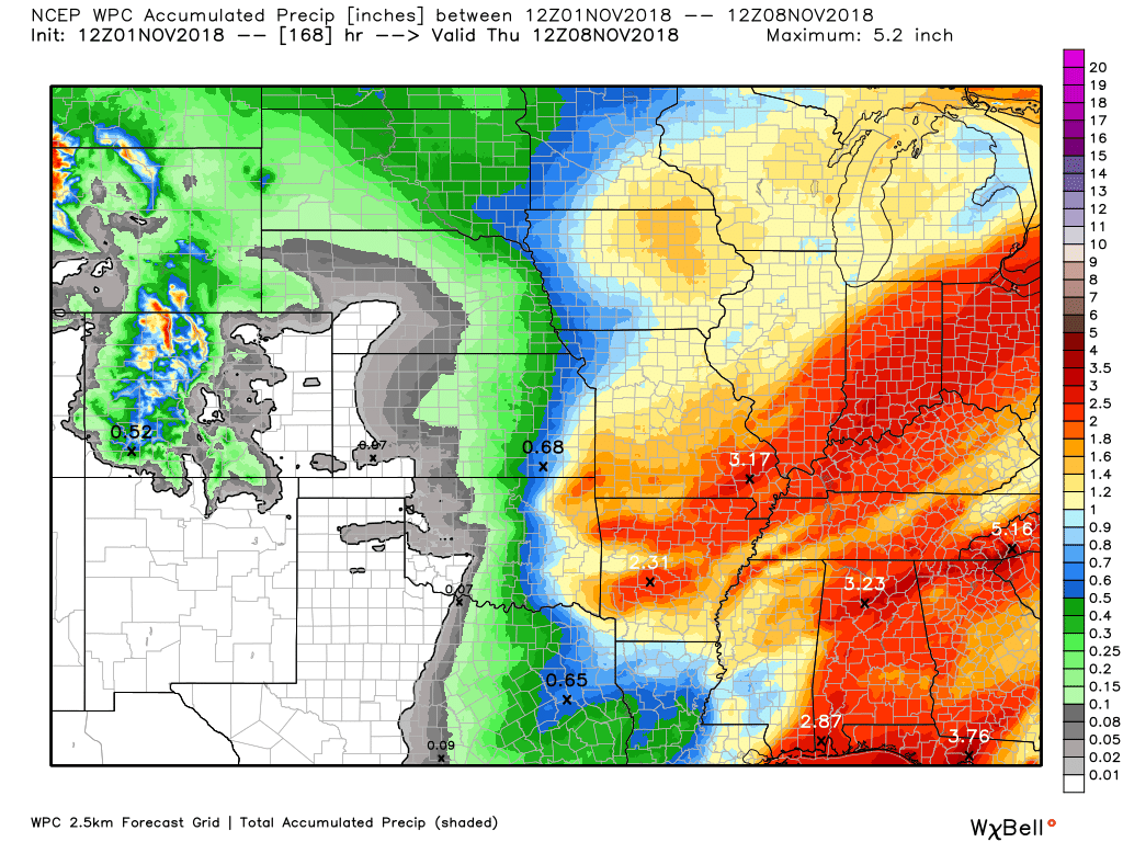
Here is the WPC/NOAA rainfall outlook
This does include some of today’s rain.
Generally, our next rain event will arrive Sunday into Tuesday. We could pick up another 0.75: to 1.25″. Locally higher.
There is a lower than normal confidence in the rainfall forecast during this time period.
Monitor updates.

Subscribers, do you need a forecast for an outdoor event?


We offer interactive local city live radars and regional radars.
If a radar does not update then try another one. If a radar does not appear to be refreshing then hit Ctrl F5 on your keyboard.
You may also try restarting your browser. The local city view radars also have clickable warnings.
During the winter months, you can track snow and ice by clicking the winterize button on the local city view interactive radars.

Questions? Broken links? Other questions?
You may email me at beaudodson@usawx.com

The National Weather Service defines a severe thunderstorm as one that produces quarter size hail or larger, 58 mph winds or greater, and/or a tornado.
Today through next Sunday: Severe weather is not anticipated.
Sunday night into Monday night: I am monitoring another system that could bring some thunderstorms to the area.
Interactive live weather radar page. Choose the city nearest your location. If one of the cities does not work then try a nearby one. Click here.
National map of weather watches and warnings. Click here.
Storm Prediction Center. Click here.
Weather Prediction Center. Click here.

Live lightning data: Click here.

Interactive GOES R satellite. Track clouds. Click here.

Here are the latest local river stage forecast numbers Click Here.
Here are the latest lake stage forecast numbers for Kentucky Lake and Lake Barkley Click Here.

- Big rain totals across the region
- A widespread one to three inches fell. There were pockets of three to five inches.
- River flooding is a concern over the coming weeks.
- I am monitoring another significant rain event Sunday into Monday night. The timing needs to be ironed out
The main weather story today will be the wind, the rain, and falling temperatures.
Most of the region picked up one to three inches of rain overnight. I recorded 5.46″ here at the Weather Observatory in Massac County, Illinois. That is a lot of rain.
Most of it fell during a 20 hour time period.
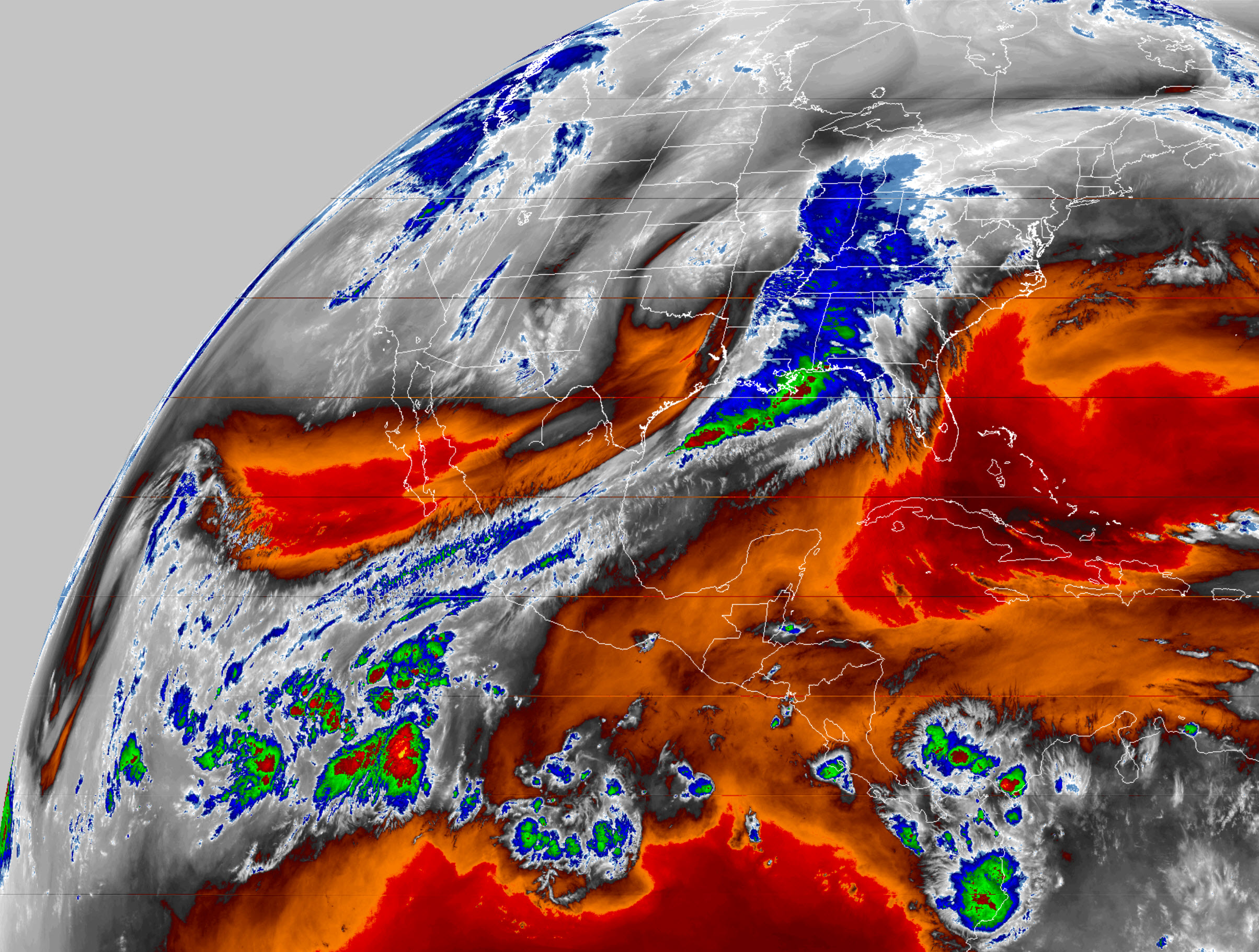
Check out the water vapor imagery this morning. The feed of moisture extends from the Pacific Ocean into our area and then north and east of here.
Click to view a larger image.
Dense fog was also an issue across some of our counties. Use care.
Winds today will be gusty. You can expect them to be northerly behind the cold front at 15 to 30 mph. Higher gusts are likely.
Winds ahead of the front will be from the south at 10 to 20 mph and gusty.
This system will depart our region by tonight. A few light showers are possible this evening.
Friday should be mostly dry. There is an outside chance of isolated showers. Most of the region will not receive measurable rainfall.
Saturday will be dry, as well.
Out next system takes shape Sunday into Tuesday.
Models are not in agreement on the exact timing of an area of low pressure that should move northeast out of Arkansas.
There is the potential of locally heavy rain, but confidence is not great enough to include it in the forecast. Not yet, at least.
Generally, rain totals should be in the 0.50″ to 1.25″ range between Sunday and Tuesday.
The peak of the rain event may end up being Sunday afternoon into Monday. Again, confidence is rather low in the timing of the event.
Here is the GFS model guidance future-cast radar. This is showing you the next rain event.
The EC model is faster with this event. GFS slower.
EC is currently the favored model, but confidence isn’t all that great on the exact timing.
Confidence is high that we will pick up additional rain.
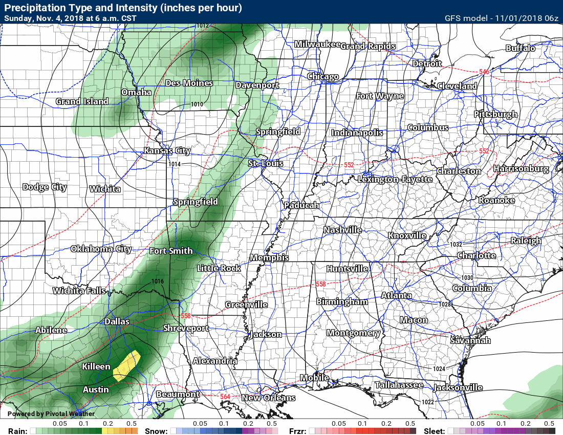
I will keep an eye on the timing. I will update accordingly. For now, plan on rain in the forecast at least Sunday and Monday.
No bitterly cold air in the charts.
Updated November outlook for subscribers!
![]()

I bring these to you from the BAMwx team. They are excellent long-range forecasters.
Remember, long-range outlooks are a bit of skill, understanding weather patterns, and luck combined. It is not an exact science.

This product is for subscribers.
Subscribe at www.weathertalk.com
Subscriber graphics can be viewed on this page CLICK HERE

This product is for subscribers.

This product is for subscribers.
Subscribe at www.weathertalk.com
Subscriber graphics can be viewed on this page CLICK HERE
![]()
.
Fall Outlook!
Preliminary October precipitation outlook
.
Here is the preliminary November temperature and precipitation outlook
.
Preliminary November temperature outlook
Preliminary November precipitation outlook
.These products are for subscribers.
![]()

A new weather podcast is now available! Weather Geeks (which you might remember is on The Weather Channel each Sunday)
To learn more visit their website. Click here.
![]()

WeatherBrains Episode 666
This week’s Guest WeatherBrain is a world-renowned meteorologist, prognosticator, and extended outlook specialist. A 1978 graduate of Penn State University with a Bachelor of Science in Meteorology and former Nittany Lion Wrestler, he worked at AccuWeather soon after graduation. He currently works for WeatherBELL Analytics as co-Chief Forecaster. Joe Bastardi, welcome to WeatherBrains!
Other discussions in this weekly podcast include topics like:
Other discussions in this weekly podcast include topics like:
Hurricane Willa approaches the Mexican coast
Winter weather outlook from the panel
Astronomy Outlook with Tony Rice
and more!
Link to their website https://weatherbrains.com/
Previous episodes can be viewed by clicking here.

We offer interactive local city live radars and regional radars. If a radar does not update then try another one. If a radar does not appear to be refreshing then hit Ctrl F5. You may also try restarting your browser.
The local city view radars also have clickable warnings.
During the winter months, you can track snow and ice by clicking the winterize button on the local city view interactive radars.
You may email me at beaudodson@usawx.com
Find me on Facebook!

Find me on Twitter!

Did you know that a portion of your monthly subscription helps support local charity projects?
You can learn more about those projects by visiting the Shadow Angel Foundation website and the Beau Dodson News website.

I encourage subscribers to use the app vs regular text messaging. We have found text messaging to be delayed during severe weather. The app typically will receive the messages instantly. I recommend people have three to four methods of receiving their severe weather information.
Remember, my app and text alerts are hand typed and not computer generated. You are being given personal attention during significant weather events.
