
.

This forecast update covers far southern Illinois, far southeast Missouri, and far western Kentucky. See the coverage map on the right side of the blog
Forecast: Partly cloudy.
Temperatures: MO ~ 60 to 65 IL ~ 60 to 65 KY ~ 60 to 65 TN ~ 62 to 66
Winds: West and southwest winds at 5 to 10 mph with gusts to 20 mph.
My confidence in the forecast verifying: High. This forecast should verify.
What impacts are anticipated from the weather? Most likely none
Is severe weather expected? No
The NWS defines severe weather as 58 mph winds or great, 1″ hail or larger, and/or tornadoes
What is the chance of precipitation? MO ~ 10% IL ~ 10% KY ~ 0% TN ~ 0%
Coverage of precipitation: Most likely none
Should I cancel my outdoor plans? No.
View the latest lake and river stage forecasts ~ here.
.
May 10, 2017
Wednesday Forecast Details
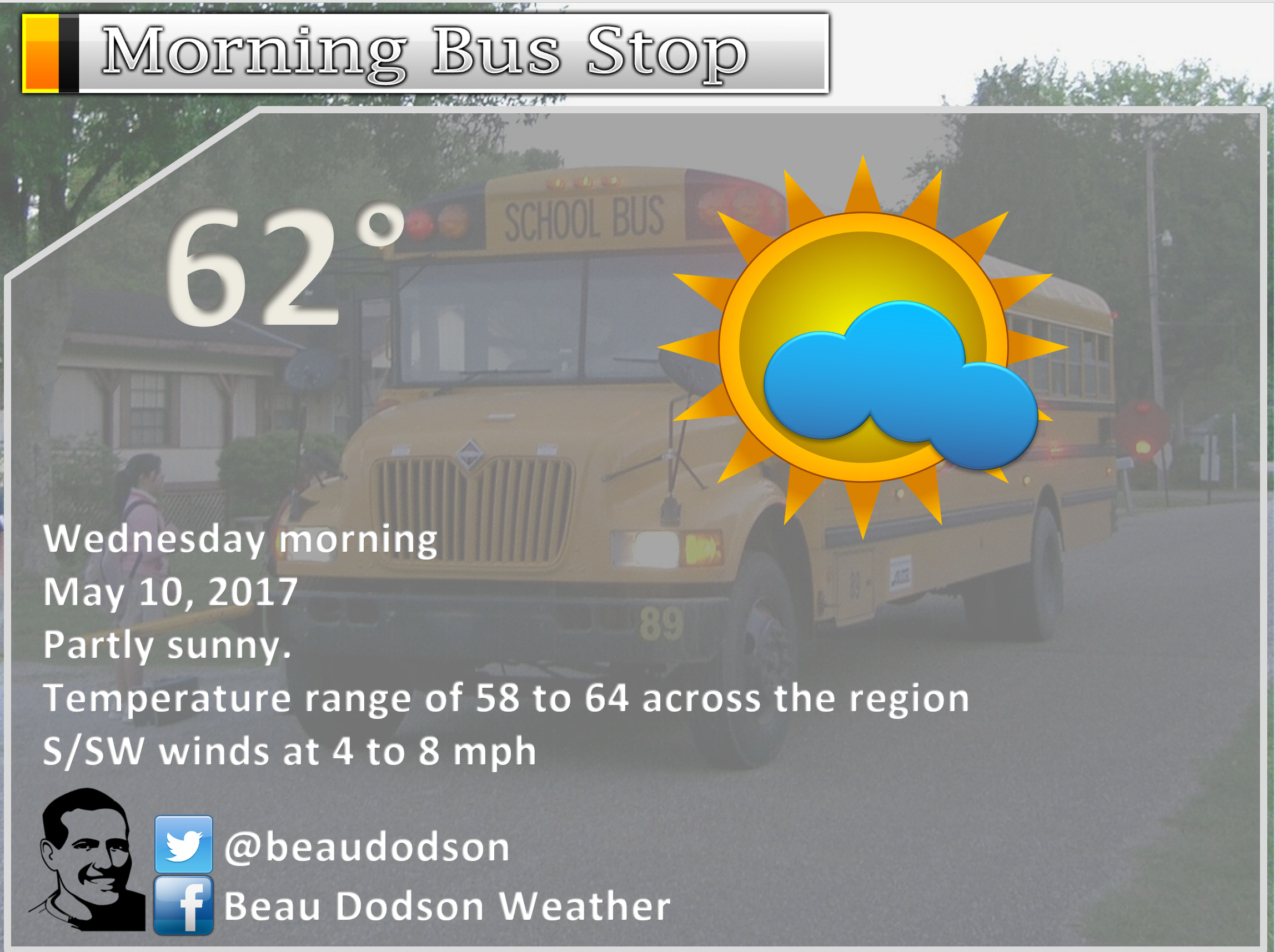
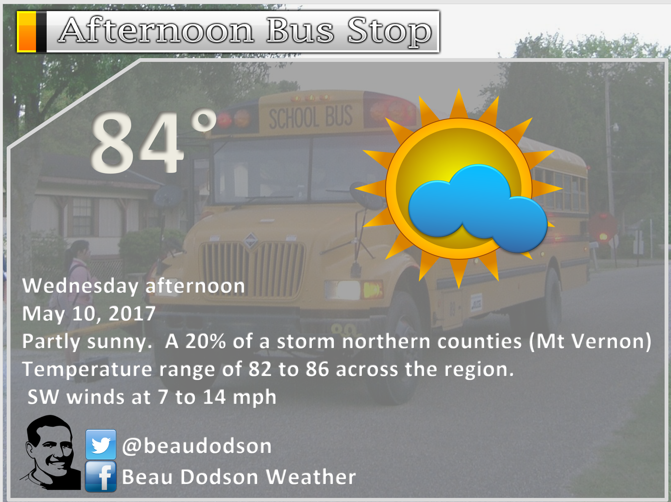
Forecast: A mix of sun and clouds. A 30% for a shower or thunderstorm over our northern counties. That would include Farmington, MO towards Mt Vernon, IL. Most of the area will remain dry on Wednesday. Warm. Well above normal temperatures.
Temperatures: MO ~ 82 to 86 IL 80 to 86 KY 82 to 87 TN 82 to 87
Winds: South and southwest at 8 to 16 mph with gusts to 22 mph
What impacts are anticipated from the weather? Far northern counties perhaps some wet roadways. Lightning. Most of the area will remain rain and lightning free.
My confidence in the forecast verifying: Medium. Some adjustments are possible.
Is severe weather expected? Low end risk for severe storms from Farmington, MO towards Mt Vernon, IL. Perhaps a better chance for storms on Wednesday night.
The NWS defines severe weather as 58 mph winds or great, 1″ hail or larger, and/or tornadoes
What is the chance of precipitation? MO ~ 30% IL ~ 30% KY ~ 10% TN ~ 0%
Coverage of precipitation: Perhaps isolated northern counties.
Should I cancel my outdoor plans? No
.
Wednesday Night Forecast Details:
Forecast: Partly to mostly cloudy. A chance for scattered showers and thunderstorms. The best chance the first half of the night will be north vs south. That would mean Perry County, MO towards Marion, IL and then towards Evansville, IN. From there northward is the best chance for spotty showers/storms. A few strong storms possible. Late at night, perhaps a few more showers south of the line mentioned above.
Temperatures: MO ~ 62 to 66 IL ~ 62 to 66 KY ~ 62 to 66 TN ~ 62 to 66
Winds: South and southwest winds at 7 to 14 mph with gusts to 25 mph
My confidence in the forecast verifying: Medium. Some adjustments are possible.
What impacts are anticipated from the weather? Wet roadways. Lightning.
Is severe weather expected? Low end risk for severe storms.
The NWS defines severe weather as 58 mph winds or great, 1″ hail or larger, and/or tornadoes
What is the chance of precipitation? MO ~ 50% IL ~ 50% KY ~ 40% TN ~ 30%
Coverage of precipitation: Scattered
Should I cancel my outdoor plans? No, but perhaps check the radars
.
May 11, 2017
Thursday Forecast Details
Forecast: Partly to mostly cloudy. A chance for showers and thunderstorms. The severe weather risk is low, but not zero. A couple of storms could be strong. Temperatures will be highly dependent on sunshine. If we have more clouds then shave several degrees off of these numbers. More sun and these numbers will verify.
Temperatures: MO ~ 76 to 84 IL 76 to 84 KY 78 to 84 TN 78 to 84
Winds: West and southwest at 5 to 10 mph with gusts to 15 mph
What impacts are anticipated from the weather? Wet roadways. Lightning. I can’t completely rule out a few storms producing gusty winds and hail.
My confidence in the forecast verifying: High. This forecast should verify.
Is severe weather expected? Low end risk for severe storms. Isolated severe weather risk.
The NWS defines severe weather as 58 mph winds or great, 1″ hail or larger, and/or tornadoes
What is the chance of precipitation? MO ~ 60% IL ~ 60% KY ~ 50% TN ~ 50%
Coverage of precipitation: Scattered to perhaps numerous
Should I cancel my outdoor plans? Have a plan B (in case it rains)
.
Thursday Night Forecast Details:
Forecast: Cloudy. A chance for showers and thunderstorms. Greatest rain chances should slide southward with time. That means decreasing chances from Farmington, MO to Mt Vernon, IL and increasing chances further south. A line of storms is possible moving northwest to southeast. A few strong storms possible.
Temperatures: MO ~ 55 to 60 IL ~ 52 to 60 KY ~ 55 to 60 TN ~ 55 to 60
Winds: South and southwest winds becoming west and northwest and then becoming north at 7 to 14 mph with gusts to 20 mph
My confidence in the forecast verifying: High. This forecast should verify.
What impacts are anticipated from the weather? Wet roadways. Lightning. I can’t rule out a few reports of strong wind and even hail.
Is severe weather expected? Monitor updates. A few strong storms are possible. Isolated severe risk.
The NWS defines severe weather as 58 mph winds or great, 1″ hail or larger, and/or tornadoes
What is the chance of precipitation? MO ~ 70% IL ~ 70% KY ~ 70% TN ~ 70%
Coverage of precipitation: Scattered to perhaps widespread.
Should I cancel my outdoor plans? Monitor updates. Have a plan B. It might rain.
.
May 12, 2017
Friday Forecast Details
Forecast: Mostly cloudy. A chance for some morning and early afternoon showers. A thunderstorm possible. Cooler. I am hoping most of the rain ends before evening. I know some of you have sporting events. See Friday rain maps further down in the blog.
Temperatures: MO ~ 66 to 74 IL 66 to 74 KY 68 to 74 TN 70 to 75
Winds: North and northeast winds at 6 to 12 mph with gusts to 20 mph.
What impacts are anticipated from the weather? Wet roadways. Perhaps lightning.
My confidence in the forecast verifying: Medium. Some adjustments are possible.
Is severe weather expected? No
The NWS defines severe weather as 58 mph winds or great, 1″ hail or larger, and/or tornadoes
What is the chance of precipitation? MO ~ 40% IL ~ 40% KY ~ 40% TN ~ 40%
Coverage of precipitation: Scattered, but ending as the day wears on.
Should I cancel my outdoor plans? Monitor updated forecasts. Some showers possible.
.
Friday Night Forecast Details:
Forecast: Partly cloudy. Cooler. Clearing overnight.
Temperatures: MO ~ 46 to 52 IL ~ 46 to 52 KY ~ 48 to 54 TN ~ 48 to 54
Winds: North at 5 to 10 mph with gusts to 15 mph
My confidence in the forecast verifying: Medium. Some adjustments are possible.
What impacts are anticipated from the weather? Most likely none. Small chance for an evening shower over our eastern counties (Pennyrile area of western Kentucky)
Is severe weather expected? No
The NWS defines severe weather as 58 mph winds or great, 1″ hail or larger, and/or tornadoes
What is the chance of precipitation? MO ~ 10% IL ~ 10% KY ~ 10% TN ~ 10%
Coverage of precipitation: None anticipated.
Should I cancel my outdoor plans? No
.
May 13, 2017
Saturday Forecast Details
Forecast: Mostly sunny. Mild.
Temperatures: MO ~ 70 to 76 IL 70 to 76 KY 70 to 76 TN 72 to 76
Winds: North winds at 5 to 10 mph.
What impacts are anticipated from the weather? None.
My confidence in the forecast verifying: High. This forecast should verify.
Is severe weather expected? No
The NWS defines severe weather as 58 mph winds or great, 1″ hail or larger, and/or tornadoes
What is the chance of precipitation? MO ~ 0% IL ~ 0% KY ~ 0% TN ~ 0%
Coverage of precipitation: None
Should I cancel my outdoor plans? No
.
Saturday Night Forecast Details:
Forecast: Mostly clear. Cool.
Temperatures: MO ~ 48 to 54 IL ~ 48 to 54 KY ~ 52 to 56 TN ~ 52 to 56
Winds: North at 5 to 10 mph. Winds becoming variable in direction.
My confidence in the forecast verifying: High. This forecast should verify.
What impacts are anticipated from the weather? None
Is severe weather expected? No
The NWS defines severe weather as 58 mph winds or great, 1″ hail or larger, and/or tornadoes
What is the chance of precipitation? MO ~ 0% IL ~ 0% KY ~ 0% TN ~ 0%
Coverage of precipitation: None
Should I cancel my outdoor plans? No
.
May 14, 2017
Sunday Forecast Details
Forecast: Partly to mostly sunny. Mild.
Temperatures: MO ~ 74 to 78 IL 74 to 78 KY 75 to 78 TN 75 to 78
Winds: South and southwest winds at 5 to 10 mph.
What impacts are anticipated from the weather?
My confidence in the forecast verifying: High. This forecast should verify.
Is severe weather expected? No
The NWS defines severe weather as 58 mph winds or great, 1″ hail or larger, and/or tornadoes
What is the chance of precipitation? MO ~ 0% IL ~ 0% KY ~ 0% TN ~ 0%
Coverage of precipitation: None
Should I cancel my outdoor plans? No
.
Sunday Night Forecast Details:
Forecast: Partly cloudy. Cooler.
Temperatures: MO ~ 50 to 55 IL ~ 50 to 55 KY ~ 50 to 55 TN ~ 50 to 55
Winds: North and northeast winds at 4 to 8 mph
My confidence in the forecast verifying: High. This forecast should verify.
What impacts are anticipated from the weather? None
Is severe weather expected? No
The NWS defines severe weather as 58 mph winds or great, 1″ hail or larger, and/or tornadoes
What is the chance of precipitation? MO ~ 0% IL ~ 0% KY ~ 0% TN ~ 0%
Coverage of precipitation: None
Should I cancel my outdoor plans? No
.
May 15, 2017
Monday Forecast Details
Forecast: Mostly sunny. Mild.
Temperatures: MO ~ 75 to 80 IL 75 to 80 KY 75 to 80 TN 75 to 80
Winds: South and southwest at 6 to 12 mph
What impacts are anticipated from the weather? None
My confidence in the forecast verifying: High. This forecast should verify.
Is severe weather expected? No
The NWS defines severe weather as 58 mph winds or great, 1″ hail or larger, and/or tornadoes
What is the chance of precipitation? MO ~ 0% IL ~ 0% KY ~ 0% TN ~ 0%
Coverage of precipitation: None
Should I cancel my outdoor plans? No
.
Monday Night Forecast Details:
Forecast: Mostly clear.
Temperatures: MO ~ 58 to 64 IL ~ 58 to 64 KY ~ 58 to 64 TN ~ 58 to 64
Winds: South and southwest at 5 mph
My confidence in the forecast verifying: Medium. Some adjustments are possible.
What impacts are anticipated from the weather? None
Is severe weather expected? No
The NWS defines severe weather as 58 mph winds or great, 1″ hail or larger, and/or tornadoes
What is the chance of precipitation? MO ~ 0% IL ~ 0% KY ~ 0% TN ~ 0%
Coverage of precipitation: None
Should I cancel my outdoor plans? No
.
.
and
.

Don’t forget to check out the Southern Illinois Weather Observatory web-site for weather maps, tower cams, scanner feeds, radars, and much more! Click here

An explanation of what is happening in the atmosphere over the coming day

A severe thunderstorm is defined as a storm that produces quarter size hail or larger, 58 mph winds or greater, and/or a tornado. That is the official National Weather Service definition of a severe thunderstorm.
Tuesday night: Severe weather is not anticipated.
Wednesday and Wednesday night: Most of Wednesday will remain dry. There is a risk for a thunderstorm from near Farmington, MO towards Mt Vernon, IL. If a storm were to form it could be strong. On Wednesday night there will be a few more storms in the region. A couple of storms could produce gusty winds and hail. The severe weather risk appears minimal.
Thursday and Thursday night: A few storms on Thursday and Thursday night could be intense. The overall severe weather risk is small, but not zero. Gusty winds and perhaps some hail reports would be the main concern. Monitor updates, as always. Perhaps greatest risk arrives late Thursday afternoon and night.
Friday into Tuesday: Severe weather is not anticipated.
Weather Analysis for the coming week:
Many rivers are flooding.
View the latest lake and river stage forecasts ~ here
What an amazing Tuesday! Temperatures soared into the 80’s. Who could ask for better weather! Plenty of sunshine, as well.
Speaking on sunshine. Have you been viewing the new GOES 16 satellite images? They are amazing. You can view some of them here ~ link
Tuesday afternoon:
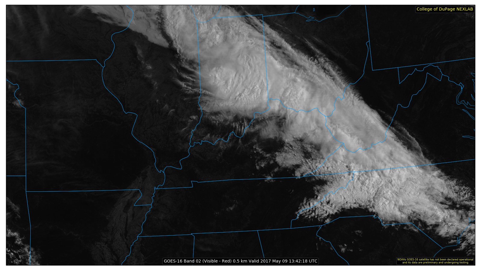
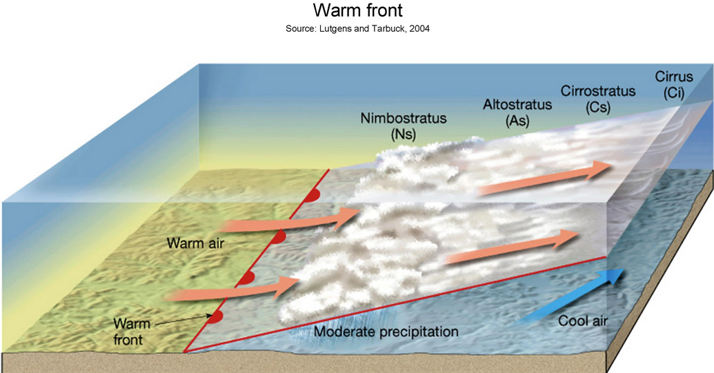
A warm front was stationed to our north. The warm air overrunning the cooler air produced clouds and showers will to our north and northeast. You can see the warm front on this satellite view. The second image is a radar view. The third image is a diagram of a warm front. You can picture it in your mind. The warmer air moving up and over the front. This helps to produce clouds and precipitation.
Satellite view. Click to enlarge.
Satellite from Tuesday morning. You can clearly see the clouds.
Radar view from Tuesday morning
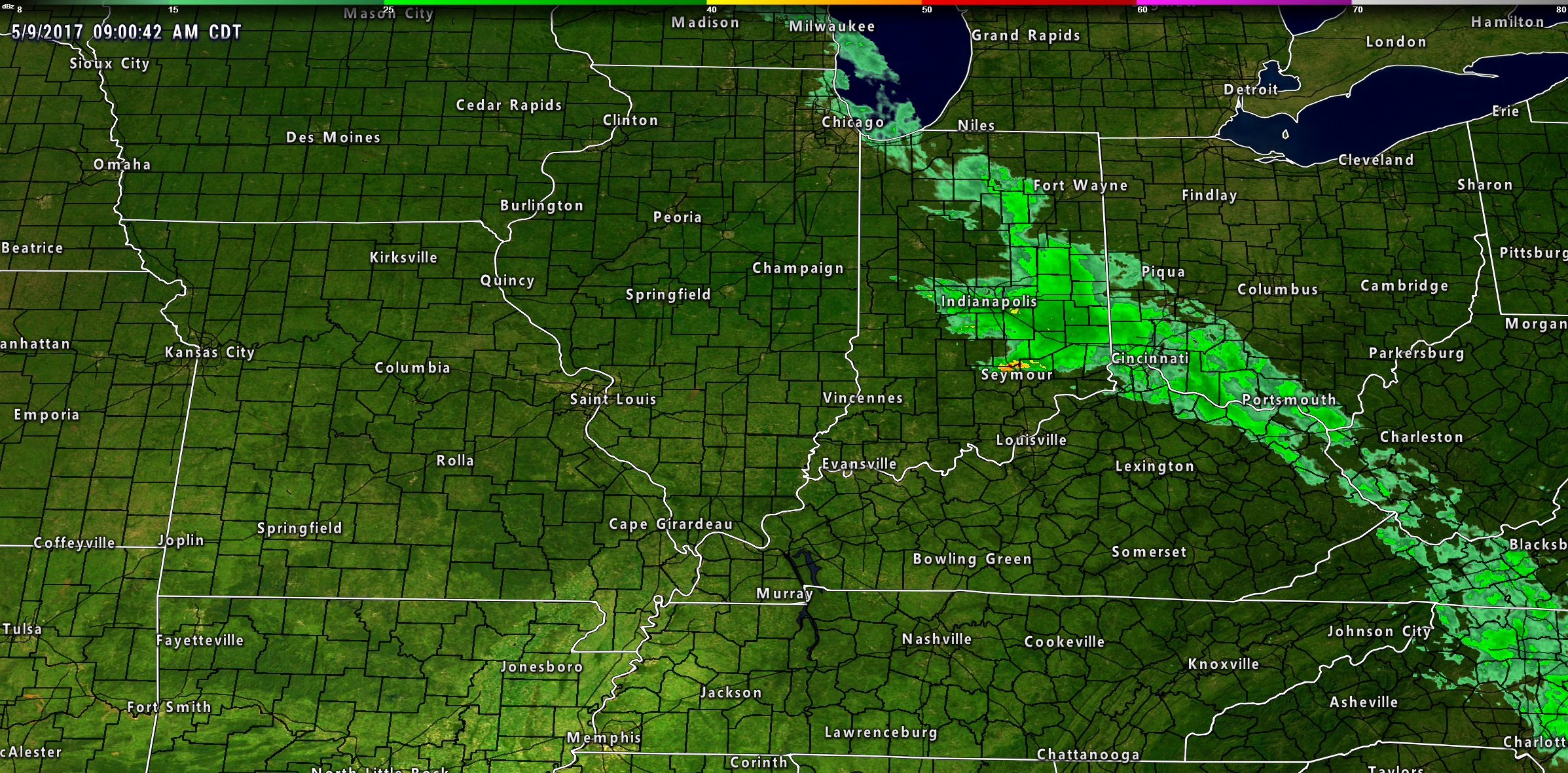
Diagram of a warm front
Wednesday and Wednesday night:
Our weather will remain nice through most of Wednesday. The front to our north will slow move southward on Wednesday afternoon and Wednesday night. This will be the beginning of increasing shower and thunderstorm chances into our local area.
On Wednesday afternoon the bulk of the rain chances will remain to our north. I can not rule out a storm moving into our far northern counties. That would include areas from Farmington, Missouri towards Mt Vernon and Carmi, Illinois. I believe rain chances will be capped at around 20% for those areas. Most of the area will remain dry and warm on Wednesday.
Rain chances increase area-wide on Wednesday night into Thursday night. The front will drape itself across our region. Some impulses will move along the front and this will help trigger showers and thunderstorms.
The peak chance for rain will likely be on Thursday and Thursday night. Keep that in mind.
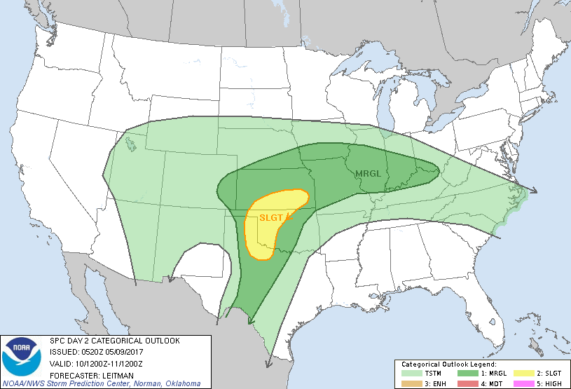
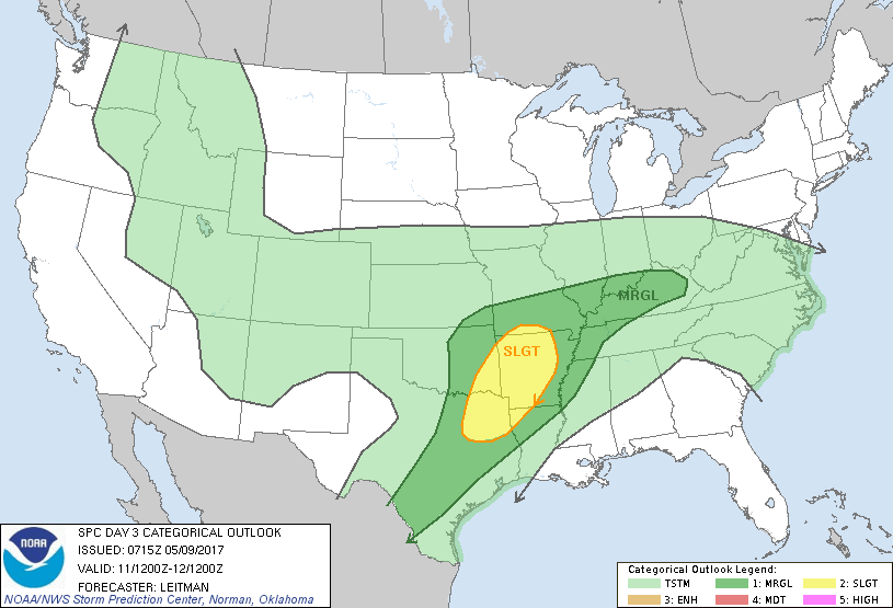
The severe weather risk from Wednesday into Thursday night is low. Perhaps a marginal risk. The Storm Prediction Center has outlined our area in dark green. That is a marginal risk for severe weather. That is a level one out of five risk. Low end of the range.
Here is the Storm Prediction Center severe weather outlook.
Light green represents thunderstorms, but below severe levels.
Dark green represents a marginal risk. That would be a level one out of five risk.
Yellow represents a slight risk for severe storms. That would be a level two our five risk.
Wednesday outlook.
Thursday outlook
Keep in mind, the SPC may shift these colors around a bit. They typically adjust them as we draw closer to the time frame in question.
For the latest SPC update you can click here ~ link
Gusty winds and hail would be the primary concern. Lightning, of course. I will keep an eye on it. The overall risk for severe weather, at your location, is small.
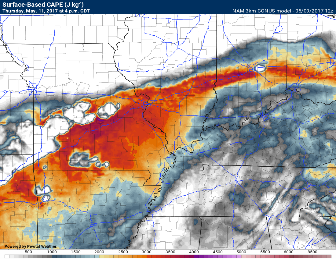
We do have some CAPE to work with. CAPE is a measure of instability. It is one ingredient when we start to think about strong storms.
Here is the CAPE map for Thursday afternoon.
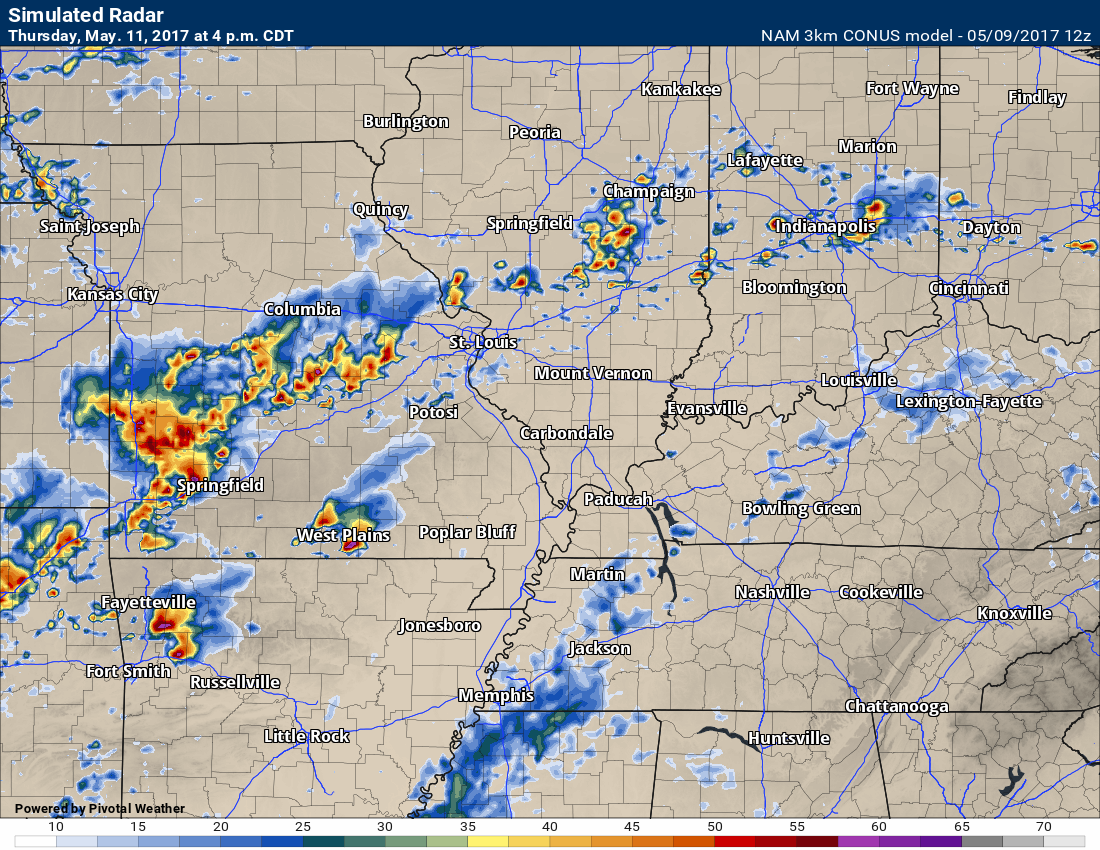
Here is the future-cast radar for Thursday afternoon and 1 pm and 7 pm.
This one is for 1 pm. You can see a band of showers and storms along the front.
This one is for 7 pm
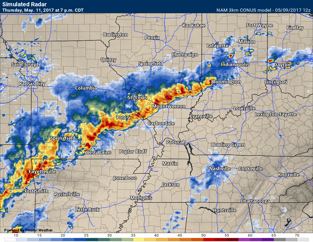
This line would move south and east with time.
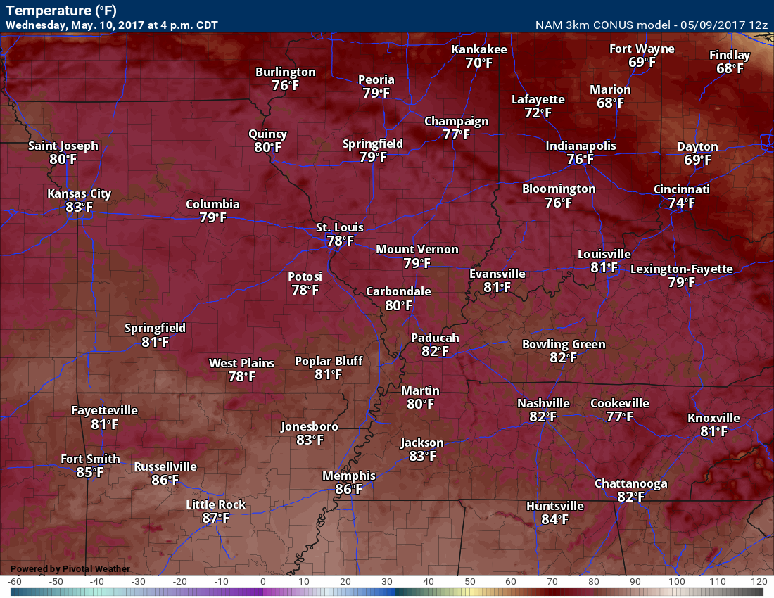
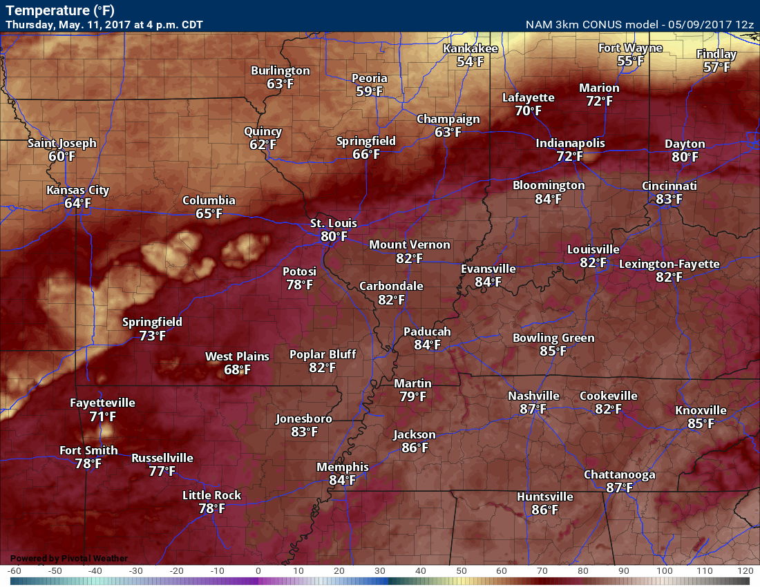
It will be warm on Wednesday and Thursday. Highs on Wednesday will once again top out in the 80’s. A summer feel to the air with higher dew points.
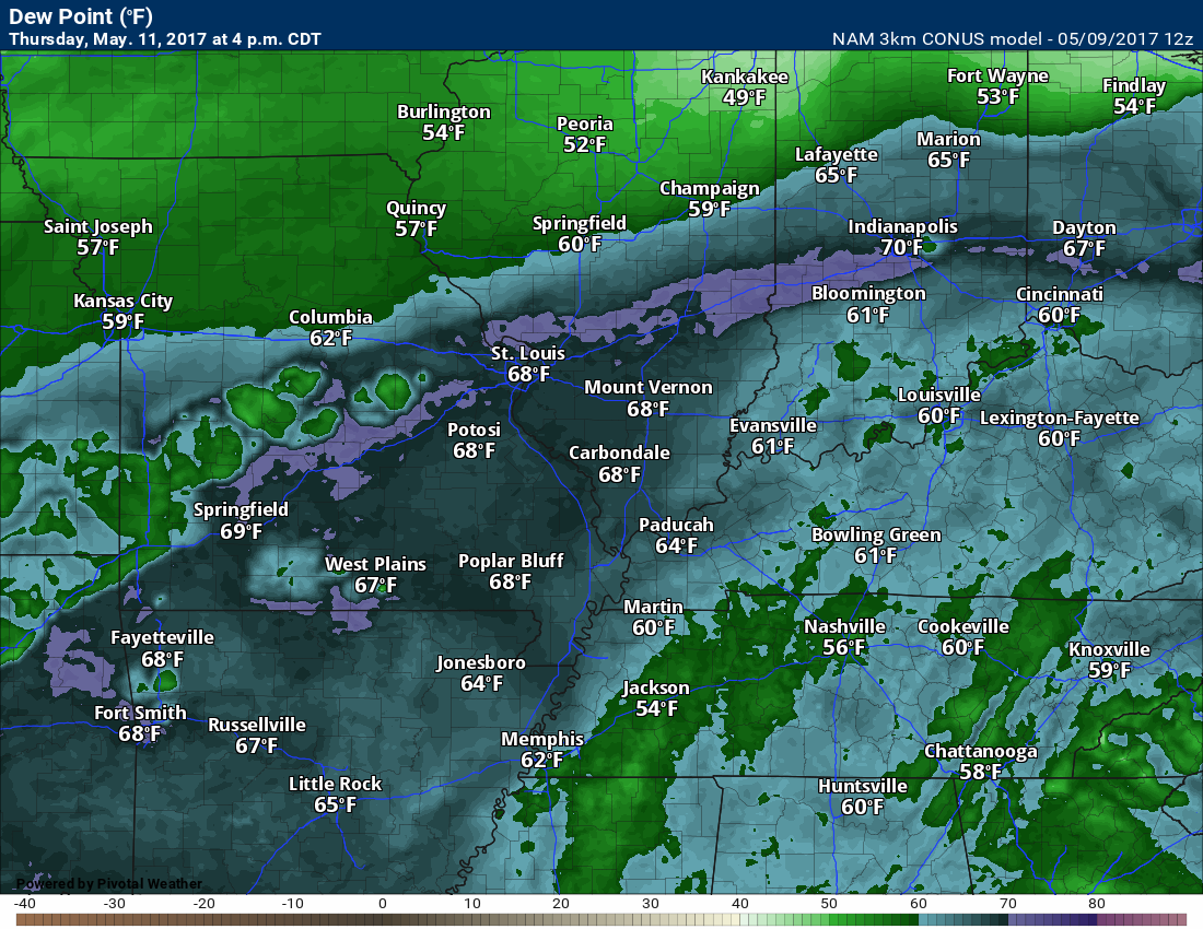
What are dew points? Dew points are a measure of moisture in the lower atmosphere.
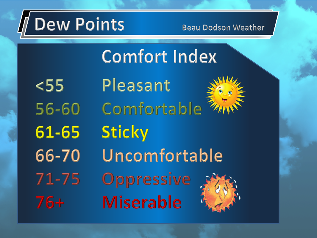
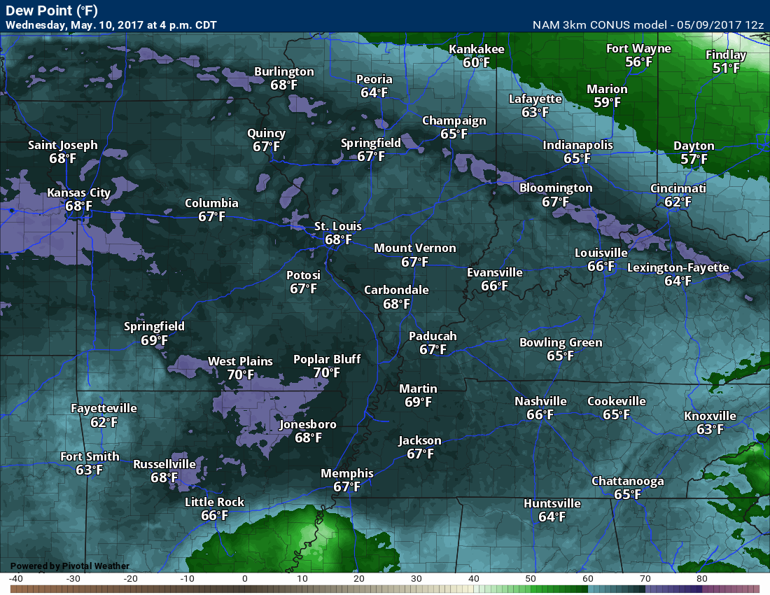
Here is the dew point forecast for Wednesday and Thursday.
Wednesday
and Thursday
The front will be near us on Thursday. With clouds and precipitation the temperatures could be a bit lower. NAM model is still forecasting widespread 80’s. We will see. Plan on upper 70’s to lower 80’s. If the clouds are thicker then shave several degrees off those highs. If we have more sun then the widespread 80’s will verify.
Here is the Wednesday and Thursday temp map from the NAM model. Notice how warm it is on Thursday. We will see. This might need adjusting.
Wednesday
And Thursday
We will cool off a bit on Friday and Saturday. Overnight lows on Friday night might dip back down into the 40’s and lower 50’s. Cooler air with less humidity. Dew points will be lower once that front exits the region. Lower dew points will mean a nicer feel to the air.
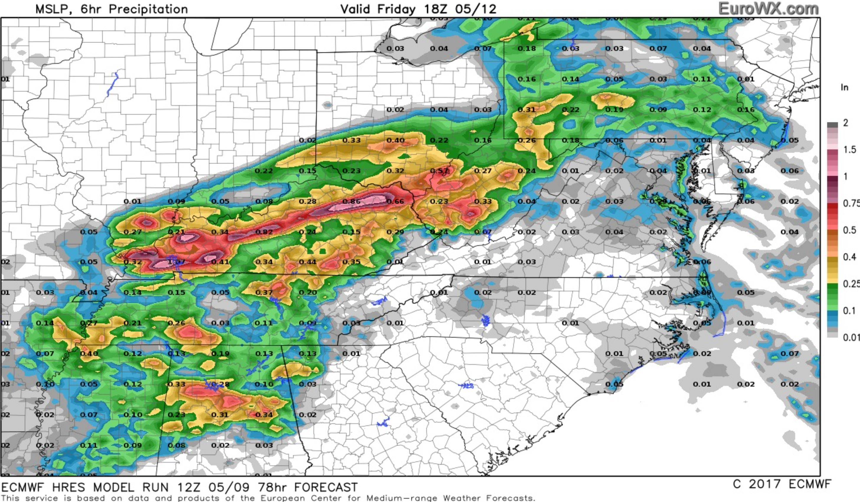
I do expect some showers on Friday. I think the best chance will be during the morning hours. Ending from west to east.
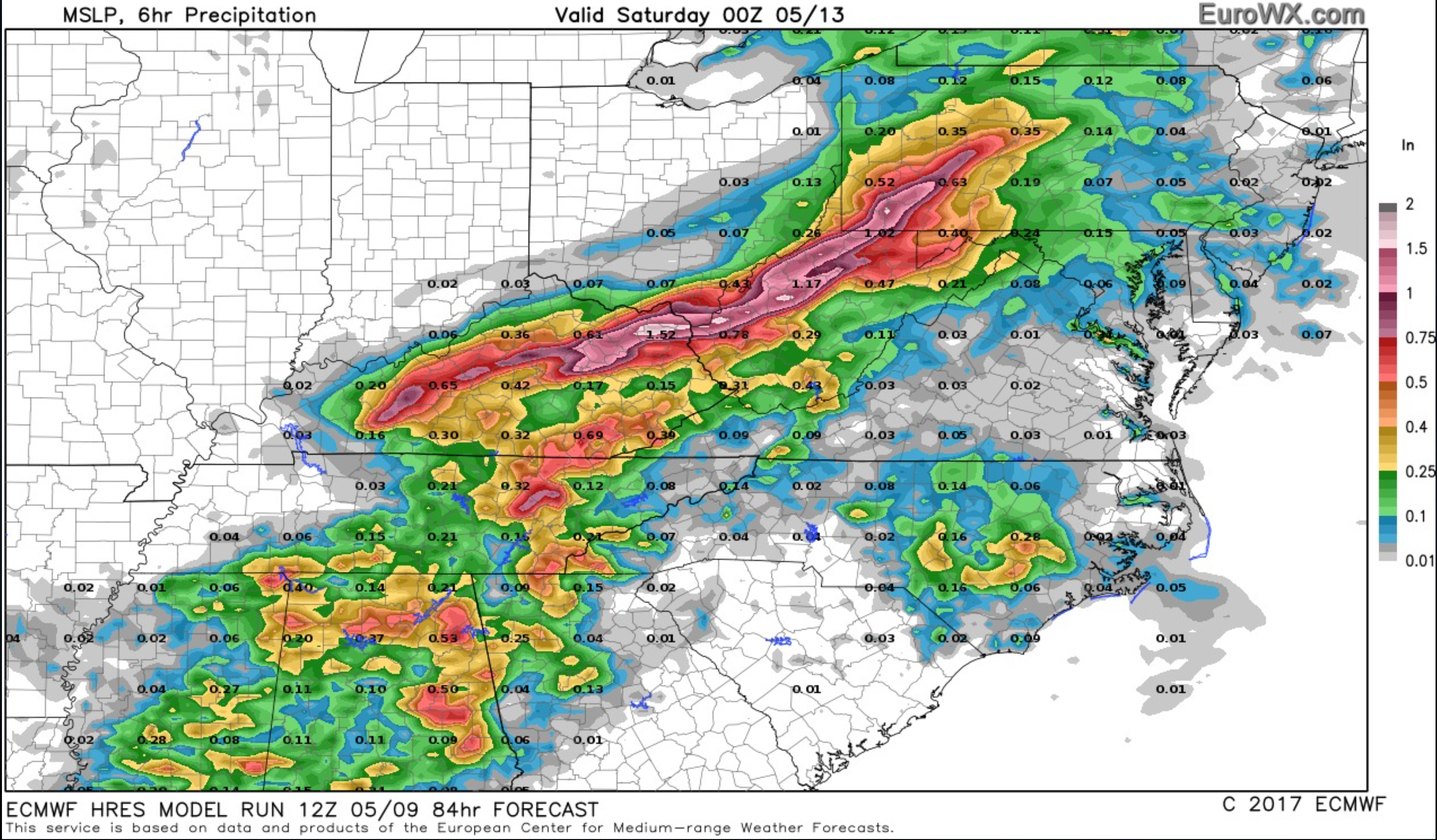
Here is the EC forecast for 7 am to 1 pm rainfall totals (Friday). The second map is 1 pm to 7 pm Friday. Notice the shift eastward.
and
Let’s move on to some other maps.
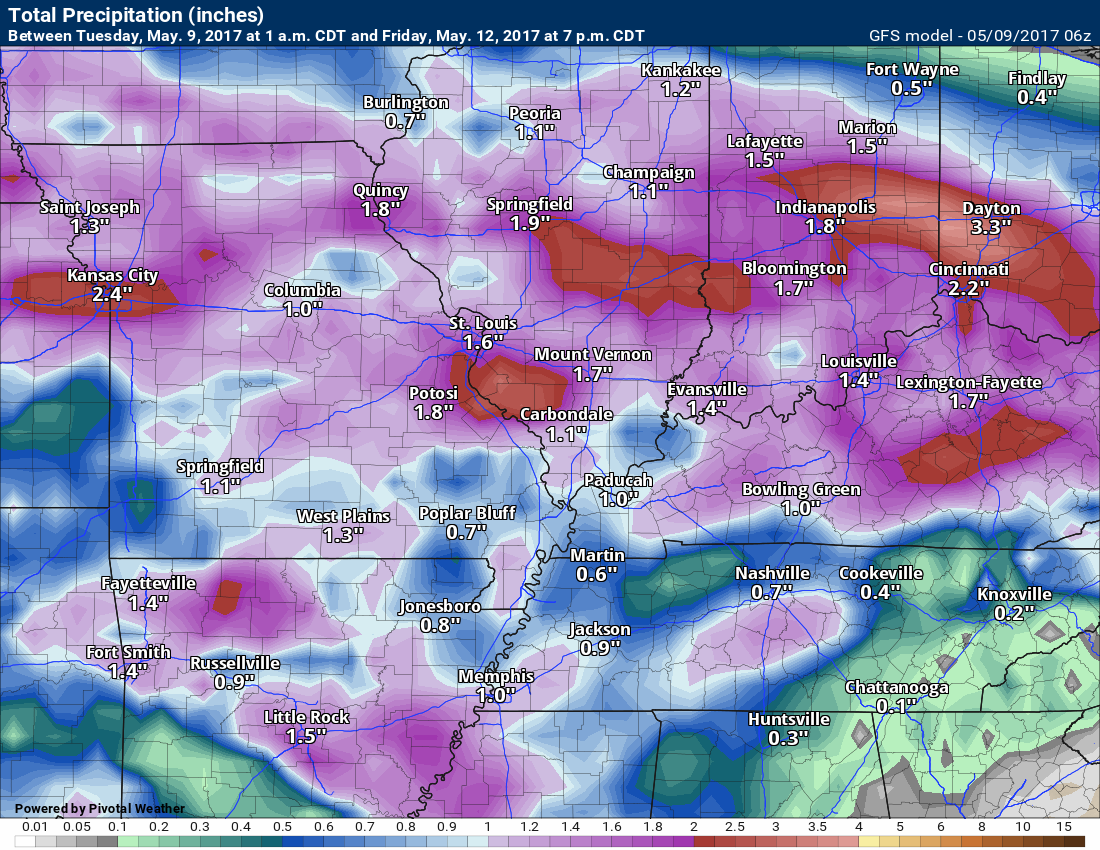
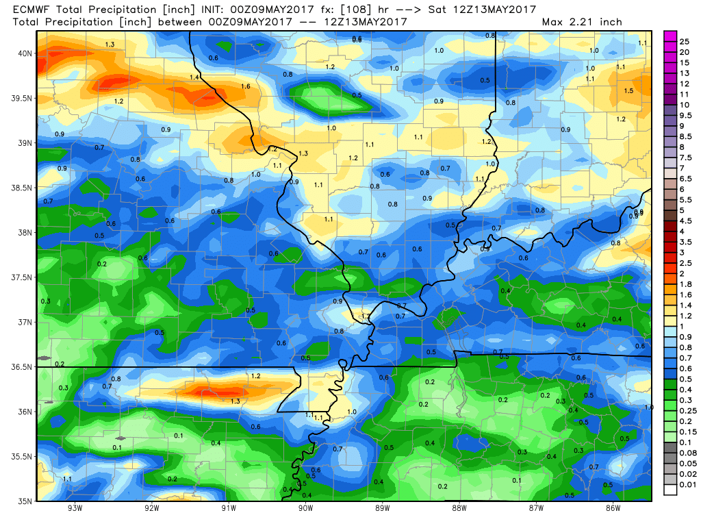
Let’s look at the guidance packages when it comes to rainfall estimates. As always, these graphics will not be exact. Take the general idea from them.
GFS
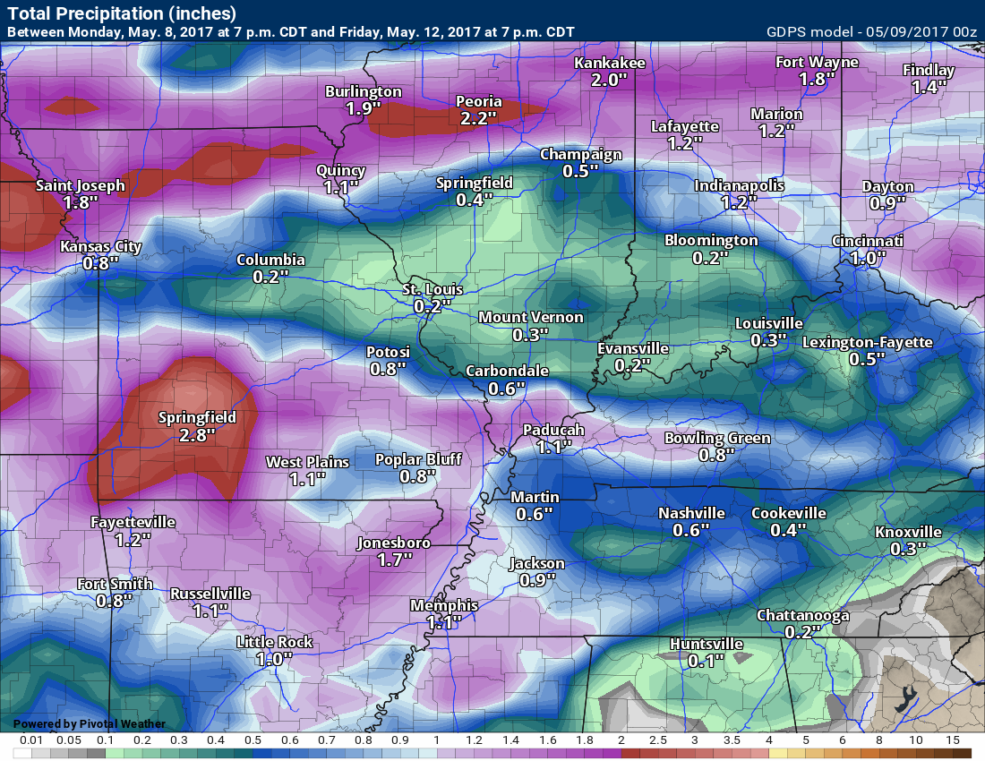
GEM model
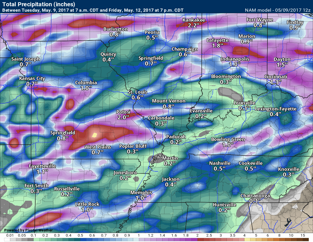
NAM model
EC model
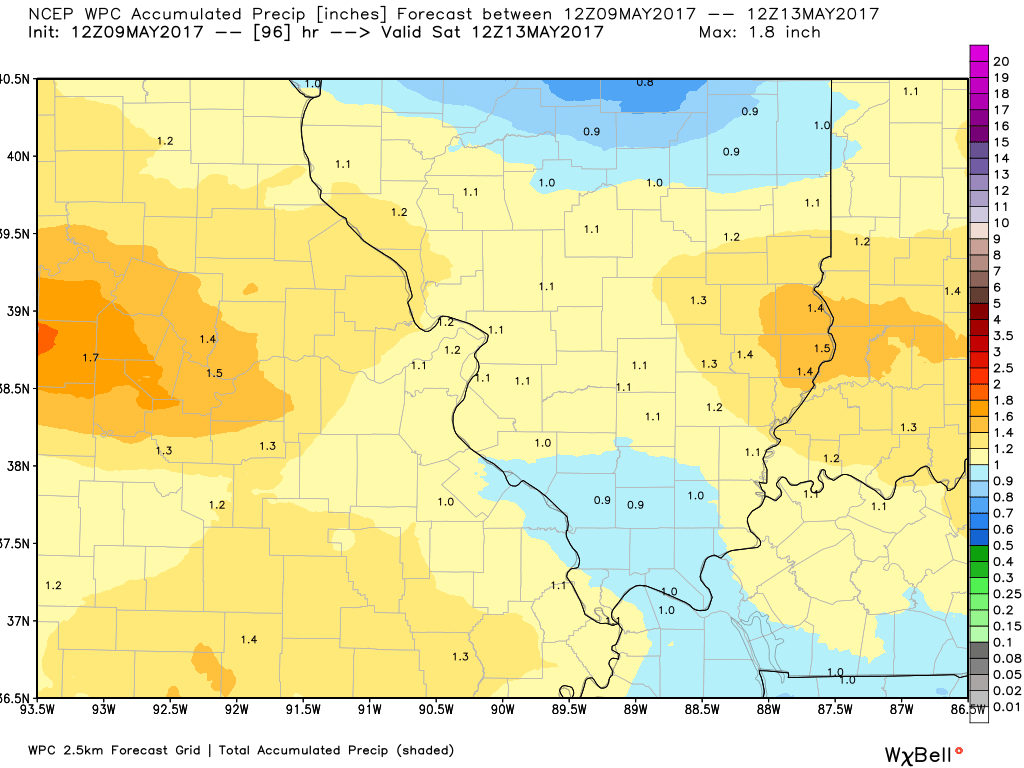
Here is what NOAA/WPC is forecasting for rainfall totals. These are through Friday evening.
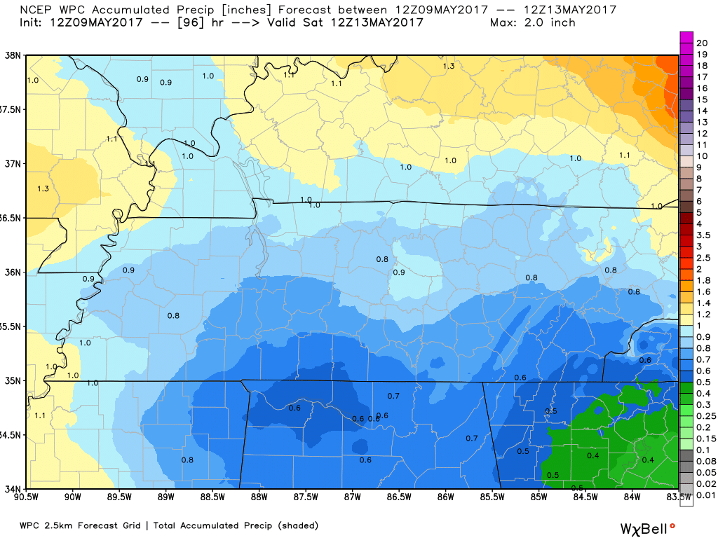
and
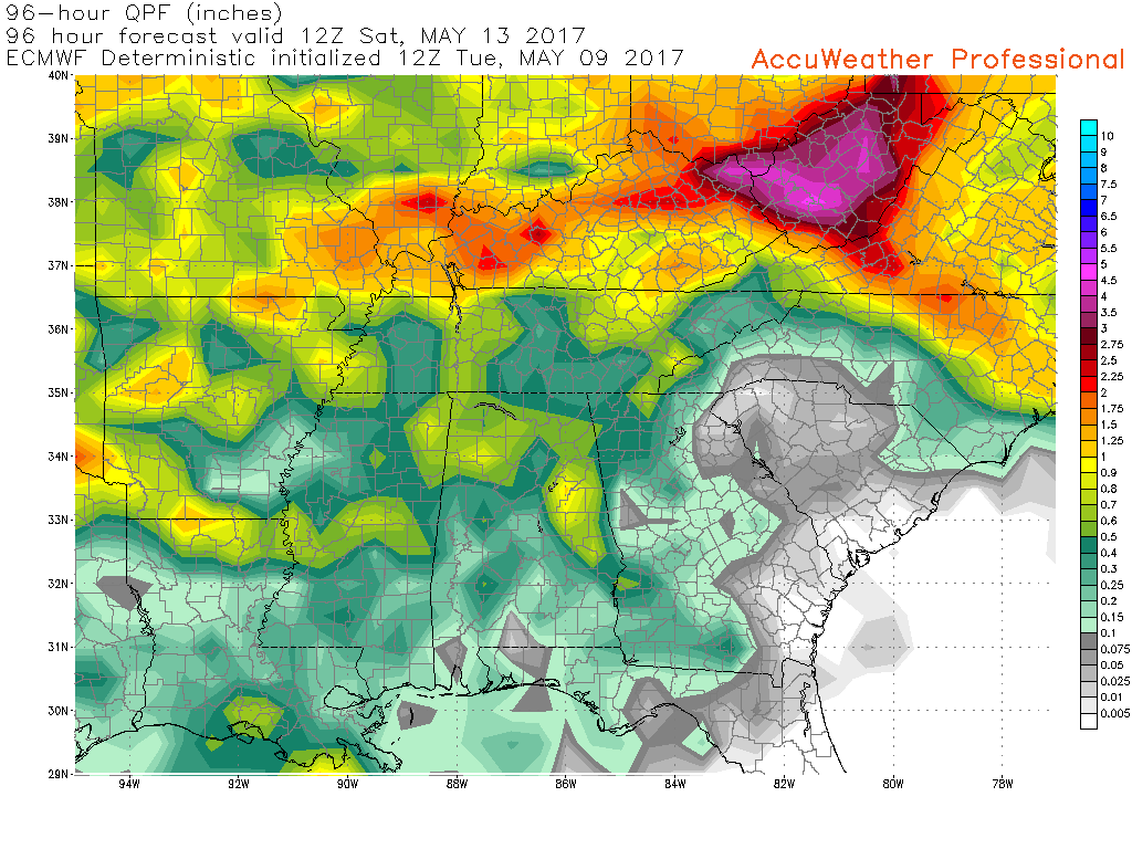
For good measure I will throw in the EC model.
One item I noted is there are portions of the region, on most of these maps, that do receive quite a bit less than other areas. This will be highly dependent on thunderstorms. Thunderstorms can always produces much higher totals. It is that time of the year.

Find me on Twitter

We have regional radars and local city radars – if a radar does not update then try another one. Occasional browsers need their cache cleared. You may also try restarting your browser. That usually fixes the problem. Occasionally we do have a radar go down. That is why I have duplicates. Thus, if one fails then try another one.
During the winter you can track snow and ice by clicking the winterize button on the local city view interactive radars.
If you have any problems then please send me an email beaudodson@usawx.com
Interactive Weather Radar Page. Choose the city nearest your location: Click this link—
National interactive radar: Click this link.
Local interactive city radars include St Louis, Mt Vernon, Evansville, Poplar Bluff, Cape Girardeau, Marion, Paducah, Hopkinsville, Memphis, Nashville, Dyersburg, and all of eastern Kentucky. These are interactive radars. Local city radars – click here
Regional Radar

The official 6-10 day and 8-14 day temperature and precipitation outlook. Check the date stamp at the top of each image (so you understand the time frame).
The forecast maps below are issued by the Weather Prediction Center (NOAA)


The latest 8-14 day temperature and precipitation outlook. Note the dates are at the top of the image. These maps DO NOT tell you how high or low temperatures or precipitation will be. They simply give you the probability as to whether temperatures or precipitation will be above or below normal.


The Beau Dodson Weather APP is ready for Apple and Android users. The purpose of this app is for me to deliver your text messages instantly. ATT and Verizon have not always been reliable when it comes to speed. The app allows instant delivery.
Some of you have asked if you can keep receiving the texts on your phone and the app. The answer to that is, yes. The Android app will automatically allow that to happen. On the Apple app, however, you will need to go into your app and click settings. Make sure the green tab is OFF. Off means you will still receive the texts to your phone and the app. If you have any questions, then email me at beaudodson@usawx.com
The app is for text subscribers.
The direct download, for the Apple app, can be viewed here
https://itunes.apple.com/us/app/id1190136514
If you have not signed up for the texting service then you may do so at www.beaudodsonweather.com

The Android app is also ready.
Remember, the app’s are for www.weathertalk.com subscribers. The app allows your to receive the text messages faster than ATT and Verizon.
Here is the download link for the Android version Click Here

——————————————————–
If you have not signed up for the texts messages, then please do. Link www.beaudodsonweather.com
Your support helps with the following:

and


Who do you trust for your weather information and who holds them accountable?
I have studied weather in our region since the late 1970’s. I have 39 years of experience in observing our regions weather patterns. My degree is in Broadcast Meteorology and a Bachelor’s of Science.
My resume includes:
Member of the American Meteorological Society.
NOAA Weather-Ready Nation Ambassador.
Meteorologist for McCracken County Emergency Management. I served from 2005 through 2015.
Meteorologist for McCracken County Rescue. 2015 through current
I own and operate the Southern Illinois Weather Observatory.
I am the chief meteorologist for Weather Talk LLC. I am the owner of Weather Talk LLC.
I am also a business owner in western Kentucky.
Recipient of the Mark Trail Award, WPSD Six Who Make A Difference Award, Kentucky Colonel, and the Caesar J. Fiamma” Award from the American Red Cross.
In 2005 I helped open the largest American Cross shelter in U.S. history in Houston, Texas. I was deployed to help after Hurricane Katrina and Hurricane Rita. I was a shelter manager of one of the Houston, Texas shelter divisions.
In 2009 I was presented with the Kentucky Office of Highway Safety Award.
Recognized by the Kentucky House of Representatives for my service to the State of Kentucky leading up to several winter storms and severe weather outbreaks.
If you click on the image below you can read the Kentucky House of Representatives Resolution.

I am also President of the Shadow Angel Foundation which serves portions of western Kentucky and southern Illinois.
There is a lot of noise on the internet. A lot of weather maps are posted without explanation. Over time you should learn who to trust for your weather information.
My forecast philosophy is simple and straight forward.
- Communicate in simple terms
- To be as accurate as possible within a reasonable time frame before an event
- Interact with you on Twitter, Facebook, email, texts, and this blog
- Minimize the “hype” that you might see on some television stations or through other weather sources
- Push you towards utilizing wall-to-wall LOCAL TV coverage during severe weather events
Many of the graphics on this page are from www.weatherbell.com
WeatherBell is a great resource for weather model guidance.


You can sign up for my AWARE email by clicking here I typically send out AWARE emails before severe weather, winter storms, or other active weather situations. I do not email watches or warnings. The emails are a basic “heads up” concerning incoming weather conditions