We have some great sponsors for the Weather Talk Blog. Please let our sponsors know that you appreciate their support for the Weather Talk Blog.
Milner and Orr Funeral Home and Cremation Services located in Paducah, Kentucky and three other western Kentucky towns – at Milner and Orr they believe in families helping families. You can find Milner and Orr on Facebook, as well.
![]()
.

For all of your families eye care needs. Visit their web-site here. Or, you can also visit their Facebook page.
.

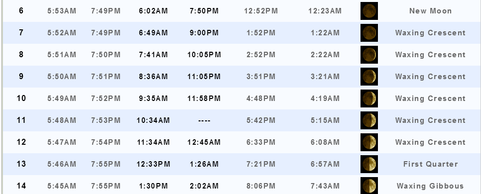
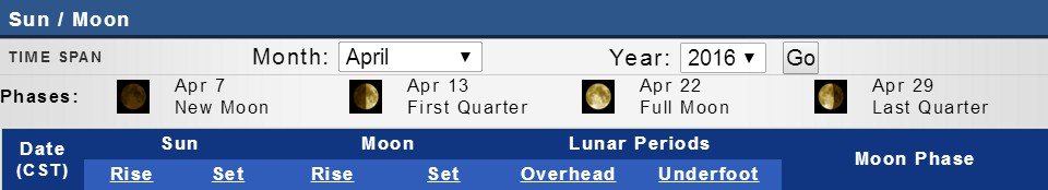
Best at Enabling Body Shop Profitability since 1996. Located In Paducah Kentucky and Evansville Indiana; serving all customers in between. They provide Customer Service, along with all the tools necessary for body shops to remain educated and competitive. Click the logo above for their main web-site. You can find McClintock Preferred Finishes on Facebook, as well

Expressway Carwash and Express Lube are a locally owned and operated full service Carwash and Lube established in 1987. We have been proudly serving the community for 29 years now at our Park Avenue location and 20 years at our Southside location. We have been lucky enough to partner with Sidecar Deli in 2015, which allows us to provide our customers with not only quality service, but quality food as well. . If you haven’t already, be sure to make Expressway your one stop shop, with our carwash, lube and deli. For hours of operation and pricing visit www.expresswashlube.com or Expressway Carwash on Facebook.

TORNADO SHELTERS! Endrizzi’s Storm Shelters – For more information click here. Endrizzi Contracting and Landscaping can be found on Facebook, as well – click here
I have launched the new weather texting service! I could use your help. Be sure and sign up and fully support all of the weather data you see each day.
This is a monthly subscription service. Supporting this helps support everything else. The cost is $3 a month for one phone, $5 a month for three phones, and $10 a month for seven phones.
For more information visit BeauDodsonWeather.com
Or directly sign up at Weathertalk.com


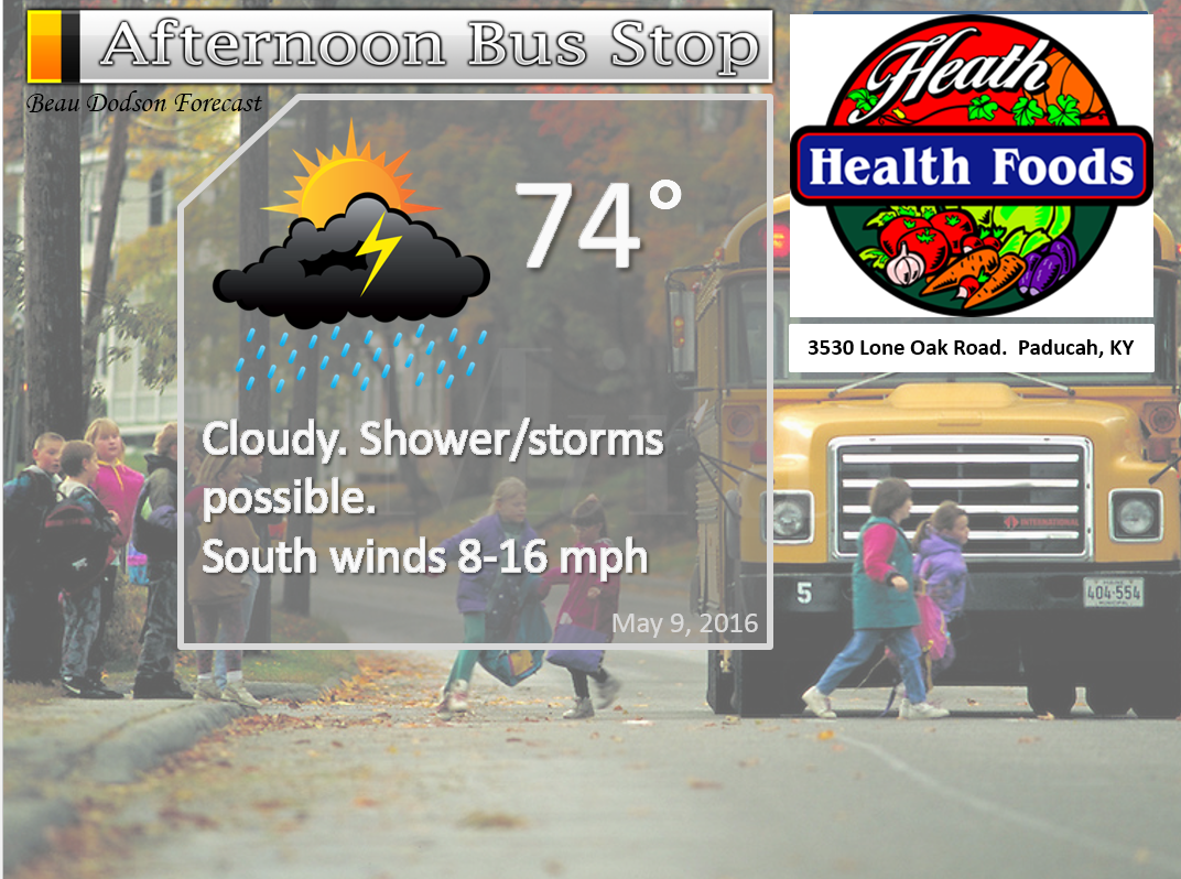
This forecast update covers far southern Illinois, far southeast Missouri, and far western Kentucky. See the coverage map on the right side of the blog.
Remember that weather evolves. Check back frequently for updates, especially during active weather.

Your Interactive City View Radars: Track the rain
Need a lightning tracker website? Here you go
Active week of weather ahead of us. Monitor updated forecasts.
Sunday Night – Partly cloudy. Some light rain before midnight. Mainly over southeast Missouri. Scattered showers and thunderstorms possible after midnight.
Temperatures: Lows in the middle 60s
Winds: Winds south and southwest winds at 6-12 mph.
What is the chance for precipitation? 30% before 12 am. Increasing to 60% by morning.
Coverage of precipitation: Scattered to perhaps numerous.
My confidence in this part of the forecast verifying is High
Should I be concerned about snow or ice? No
Should I cancel my outdoor plans? No
Is severe weather expected? No.
What impact is expected? Wet roadways. Lightning.
Quite a few on/off chances for rain and storms this week. Won’t rain all of the time. But, certainly periods of showers and thunderstorms.
Monday – Quite a few clouds. A chance for showers and thunderstorms.
Temperatures: High temperatures in the middle 70s
Winds: South and southwest winds at 7-14 mph with gusts to 20 mph
What is the chance for precipitation? 50%
Coverage of precipitation? Scattered to numerous
My confidence in this part of the forecast verifying is High
Should I be concerned about snow or ice? No
Should I cancel my outdoor plans? Some rain is possible. Monitor radars.
Is severe weather expected? A few storms could be intense Monday afternoon. More likely Monday night.
What impact is expected? Wet roadways. Lightning.
Monday Night – Cloudy. Thunderstorms possible. Some storms could be heavy.
Temperatures: Lows in the lower 60s
Winds: Winds south at 6-12 mph with gusts to 20 mph
What is the chance for precipitation? 60%-70%
Coverage of precipitation: Numerous to widespread
My confidence in this part of the forecast verifying is High
Should I be concerned about snow or ice? No
Should I cancel my outdoor plans? Have a plan B.
Is severe weather expected? A few storms could produce damaging winds and hail.
What impact is expected? Wet roadways. Lightning. Locally heavy rain. Locally severe thunderstorms are possible. Main concern would be damaging winds and hail. Isolated tornado risk.
Tuesday – Quite a few clouds. Showers and thunderstorms possible.
Temperatures: High temperatures in the 75-80 degree range
Winds: South winds at 8-16 mph. Gusts to 20-25 mph.
What is the chance for precipitation? 50%-60%
Coverage of precipitation? Scattered to numerous
My confidence in this part of the forecast verifying is Medium
Should I be concerned about snow or ice? No
Should I cancel my outdoor plans? Have a plan B
Is severe weather expected? Some storms could be intense. Monitor updates
What impact is expected? Wet roadways. Lightning. Some strong storms are possible.
Tuesday Night – Partly cloudy. A chance for thunderstorms.
Temperatures: Lows in the lower to middle 60s
Winds: Winds south and southwest at 6-12 mph.
What is the chance for precipitation? 40%-50% (mainly early in the night)
Coverage of precipitation: Scattered to perhaps numerous early in the night.
My confidence in this part of the forecast verifying is Medium
Should I be concerned about snow or ice? No
Should I cancel my outdoor plans? Have a plan B
Is severe weather expected? Monitor updates
What impact is expected? Wet roadways. Lightning.
Wednesday – Partly sunny and very warm. A thunderstorm possible.
Temperatures: High temperatures in the lower to middle 80s.
Winds: South and southwest winds at 10-20 mph
What is the chance for precipitation? 40%
Coverage of precipitation? Isolated to scattered.
My confidence in this part of the forecast verifying is Medium
Should I be concerned about snow or ice? No
Should I cancel my outdoor plans? No, but monitor updates
Is severe weather expected? Severe storms are possible in the afternoon. Perhaps more likely Wednesday night. Monitor updates.
What impact is expected? Scattered storms could produce lightning, strong winds, hail, and heavy rain. Perhaps a better chance Wednesday night.
Wednesday Night – Thunderstorms possible. Some storms could be heavy. Monitor updates.
Temperatures: Lows in the lower to middle 60s
Winds: Winds south and southwest at 10-15 mph. Gusts to 20 mph.
What is the chance for precipitation? 50%-60%
Coverage of precipitation: Scattered to perhaps numerous
My confidence in this part of the forecast verifying is Medium
Should I be concerned about snow or ice? No
Should I cancel my outdoor plans? Have a plan B
Is severe weather expected? Severe weather is possible. Closely monitor updated forecasts.
What impact is expected? Heavy rain. Lightning. Severe storms possible.
Thursday – Partly sunny. Any morning storms ending.
Temperatures: High temperatures in the 74-78 degree range
Winds: Northwest winds at 6-12 mph.
What is the chance for precipitation? 40% before 8 am.
Coverage of precipitation? Scattered
My confidence in this part of the forecast verifying is Medium
Should I be concerned about snow or ice? No
Should I cancel my outdoor plans? No
Is severe weather expected? Any overnight storms should be winding down. Monitor updates concerning Wednesday night.
What impact is expected? Wet roadways. Lightning.
Thursday Night – Clearing.
Temperatures: Lows in the lower to middle 50s
Winds: Winds west at 5 mph.
What is the chance for precipitation? 0%
Coverage of precipitation: None
My confidence in this part of the forecast verifying is Medium
Should I be concerned about snow or ice? No
Should I cancel my outdoor plans? No
Is severe weather expected? No
What impact is expected? None
Friday – Partly sunny.
Temperatures: High temperatures in the 74-78 degree range
Winds: West winds at 6-12 mph
What is the chance for precipitation? 10%
Coverage of precipitation? Most likely none.
My confidence in this part of the forecast verifying is Medium
Should I be concerned about snow or ice? No
Should I cancel my outdoor plans? No
Is severe weather expected? No
What impact is expected? None
Friday Night – Partly cloudy. A thunderstorm possible.
Temperatures: Lows in the lower to middle 50s
Winds: Winds west at 5-10 mph with gusts to 15 mph
What is the chance for precipitation? 20%-30%
Coverage of precipitation: Scattered
My confidence in this part of the forecast verifying is Low
Should I be concerned about snow or ice? No
Should I cancel my outdoor plans? No
Is severe weather expected? No
What impact is expected? Wet roadways. Lightning.
Saturday – Mostly sunny. Cooler.
Temperatures: High temperatures in the 62-66 degree range.
Winds: West/northwest winds at 4-8 mph
What is the chance for precipitation? 0%
Coverage of precipitation? None
My confidence in this part of the forecast verifying is Medium
Should I be concerned about snow or ice? No
Should I cancel my outdoor plans? No
Is severe weather expected? No
What impact is expected? None
Saturday Night – Partly cloudy. Cool.
Temperatures: Lows in the 44-48 degree range
Winds: North/northwest at 5-10 with gusts to 20-25 mph.
What is the chance for precipitation? 0%
Coverage of precipitation: None
My confidence in this part of the forecast verifying is Low
Should I be concerned about snow or ice? No
Should I cancel my outdoor plans? No
Is severe weather expected? No
What impact is expected? None
Sunday – Partly sunny.
Temperatures: High temperatures in the 65-70 degree range.
Winds: West/northwest winds at 4-8 mph
What is the chance for precipitation? 10%
Coverage of precipitation? Scattered to none
My confidence in this part of the forecast verifying is Low
Should I be concerned about snow or ice? No
Should I cancel my outdoor plans? No
Is severe weather expected? No
What impact is expected? None
Sunday Night – Partly cloudy. A shower possible. Cool.
Temperatures: Lows in the 48-52 degree range
Winds: Winds northwest at 5-10 mph.
What is the chance for precipitation? 10%
Coverage of precipitation: None to scattered
My confidence in this part of the forecast verifying is Low
Should I be concerned about snow or ice? No
Should I cancel my outdoor plans? No
Is severe weather expected?
What impact is expected?
Monday – Partly sunny. Cool.
Temperatures: High temperatures in the 64-68 degree range.
Winds: West winds at 4-8 mph
What is the chance for precipitation? 10%
Coverage of precipitation? Scattered to none
My confidence in this part of the forecast verifying is Low
Should I be concerned about snow or ice? No
Should I cancel my outdoor plans? No
Is severe weather expected?
What impact is expected?
The School Bus Stop Forecast is sponsored by Heath Health and Wellness. Located next to Crowell Pools in Lone Oak, Kentucky.
Visit their web-site here. And. visit Heath Health Foods on Facebook!


The School Bus Stop Forecast is sponsored by Heath Health and Wellness. Located next to Crowell Pools in Lone Oak, Kentucky.
Visit their web-site here. And. visit Heath Health Foods on Facebook!
Heath Health Foods is a locally owned and operated retail health and wellness store. Since opening in February 2006; the store has continued to grow as a ministry with an expanding inventory which also offers wellness appointments and services along with educational opportunities. Visit their web-site here. And. visit Heath Health Foods on Facebook!

Don’t forget to check out the Southern Illinois Weather Observatory web-site for weather maps, tower cams, scanner feeds, radars, and much more! Click here

An explanation of what is happening in the atmosphere over the coming days…
- On and off showers and storms this week
- Unsettled. Locally heavy rain and severe weather possible.
- Monitor updates
- Cool shot this coming weekend, again
We have an unsettled weather pattern developing for the region. I would encourage you to monitor updates. I will be sending out AWARE emails, text messages, and updated Twitter and Facebook.
The hardest part of the forecast, for the upcoming week, will be timing precipitation. There will certainly be plenty of time where it won’t be raining. But, there will also be plenty of precipitation chances.
A few periods of time stand out for the best chance for widespread precipitation. Monday into Monday night is one of those time frames. Tuesday, as well. Then again on Wednesday night.
Locally heavy rain is likely this week for some counties. Expect a widespread one to two inch rain event. Locally higher amounts. I would not be a bit surprised if someone tops three inches of rain over the coming week. Remember, thunderstorms can produce locally very heavy rain. Especially true if storms train over the same area. And, if an MCC develops then heavy rain is likely. What is an MCC/MCS? You can read more about MCC’s/MCS’s here. Basically they are large complexes of thunderstorms. On satellite they can be huge. Covering a huge chunk of real estate. They can produce heavy rain and severe weather.
We do have at least a chance for some severe weather on Monday and Monday night. Again on Tuesday and Tuesday evening. Then again on Wednesday afternoon/night. How widespread the severe weather threat ends up being will need to be monitored. Typically that is not known until 12-24 hours before the event. But, suffice to say, there is at least a chance for some damaging winds and hail in our region over the coming days. The tornado threat won’t be zero. I would encourage you to monitor updates.
The best chance for intense storms on Monday will probably be over southeast Missouri. And, most likely Monday night vs the day.
On Tuesday there are some questions about whether there will be much of a severe weather threat. But, at least some potential for high winds with storms. Maybe hail.
Wednesday afternoon and night will be the most unstable. If storms form during that time frame then they could produce severe weather. Monitor updates concerning Wednesday.
Another cold front arrives this coming Friday. This weekend might end up cool.
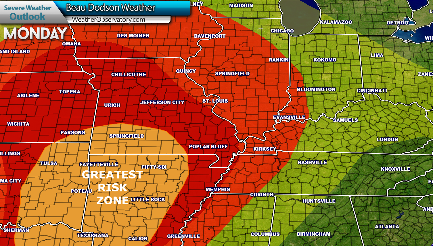
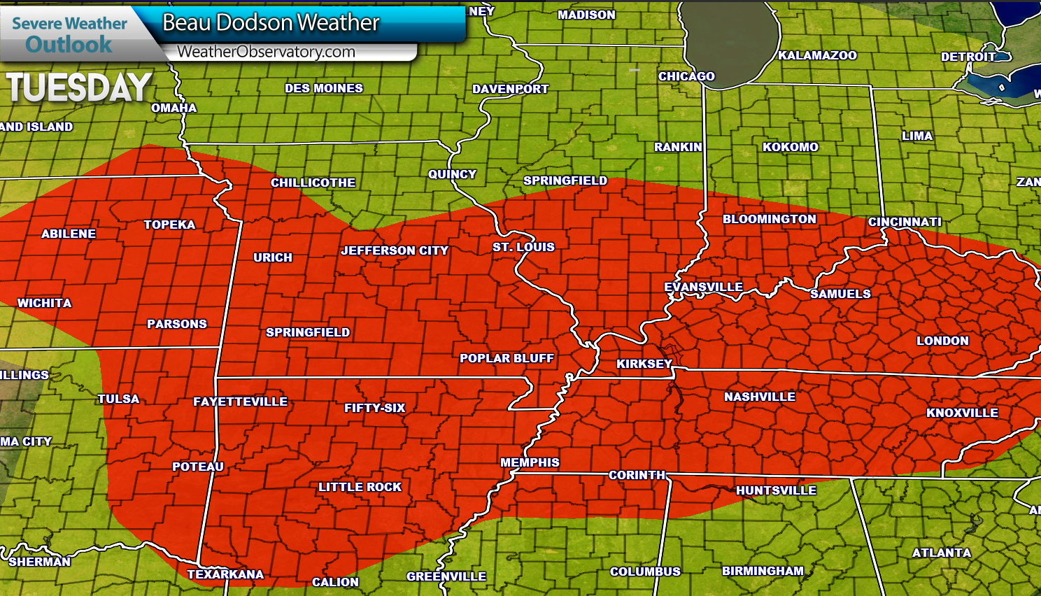
Here is the severe weather outlook for Monday and Tuesday. Red zone is where some storms could be severe. Yellow zone represents general thunderstorms, but likely not severe. Orange zone is the greatest risk.
Again, if severe weather were to occur on Monday then it would most likely be Monday night. And, perhaps the greatest risk would be over southeast Missouri.
and Tuesday
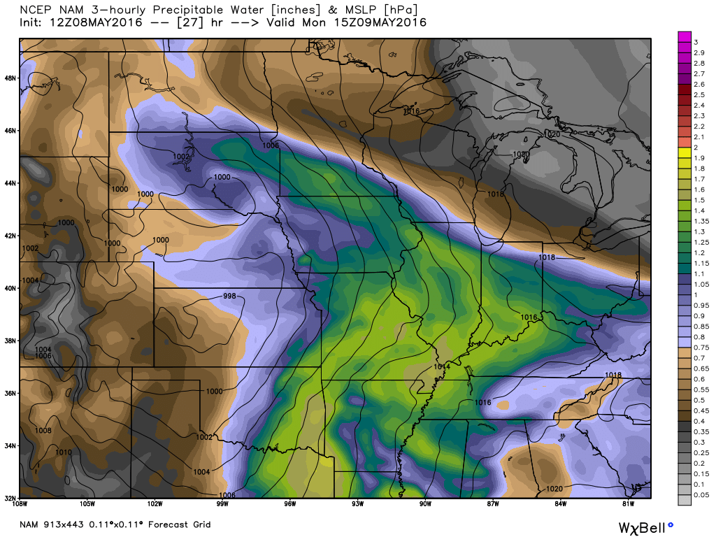
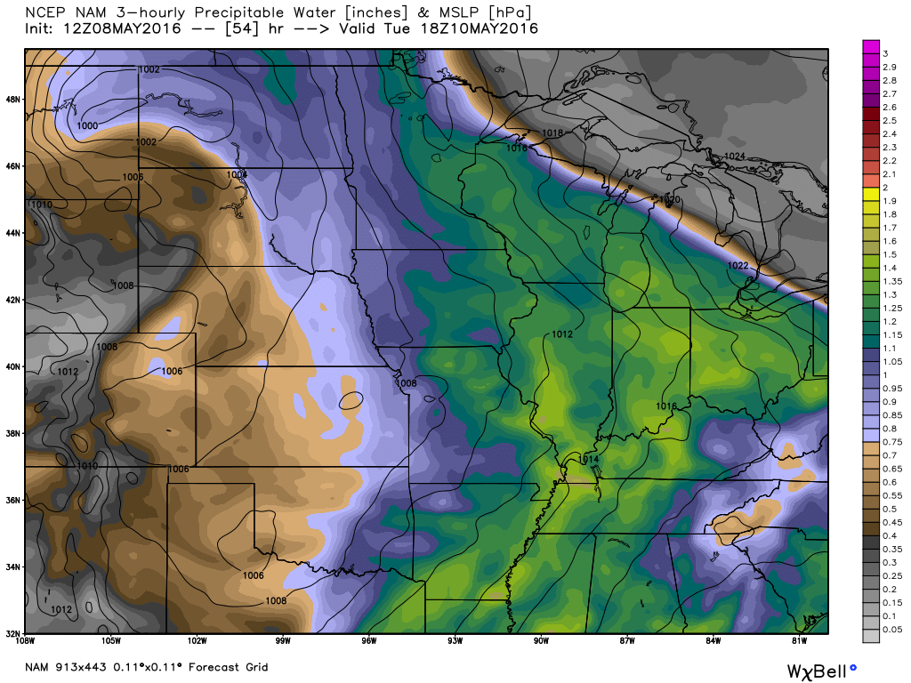
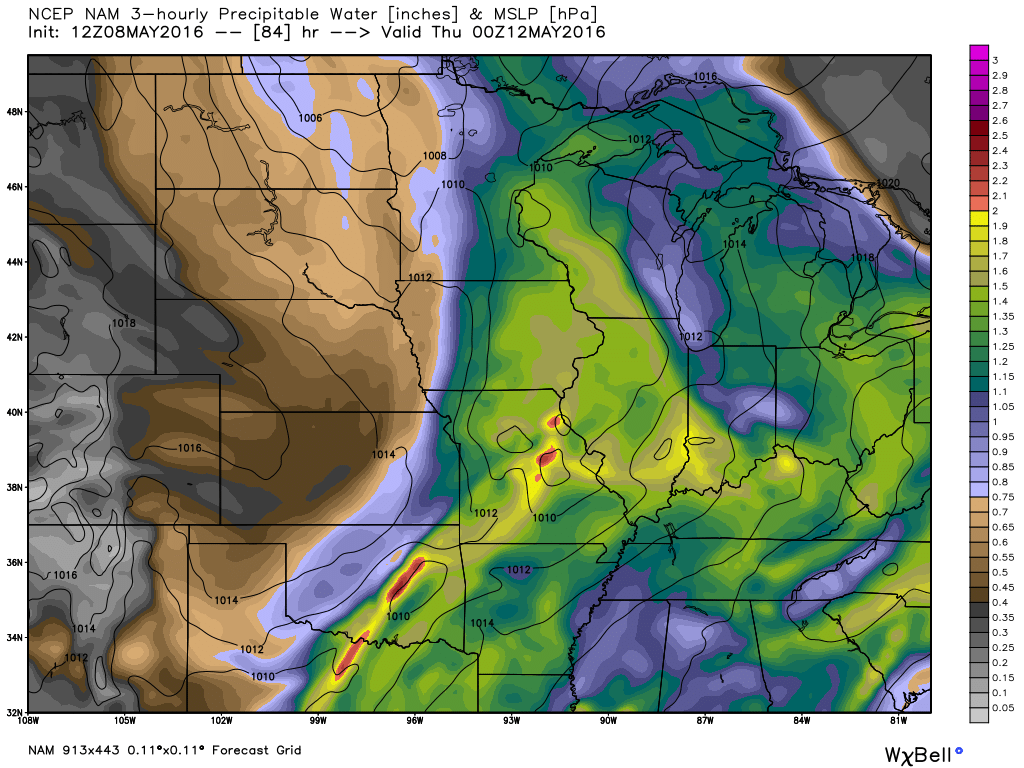
Let me show you a few maps. PWAT values will be plenty high this week. PWAT is a great way meteorologists measure moisture in the atmosphere. Not just at the surface, but also higher up into the clouds. More information on PWAT values can be read here –> I found this blog post that explains it quite well. Click here for more information on PWAT values.
This first map from weatherbell. com is for Monday. The second map is for Tuesday. The third map is for Wednesday. PWAT values are in the 1.40″-2.00″ range. That is quite a bit of moisture.
Click maps for larger views.
We also have plenty of triggers this week for storms. Several upper level impulses will push through the area. Each one could trigger showers and storms.
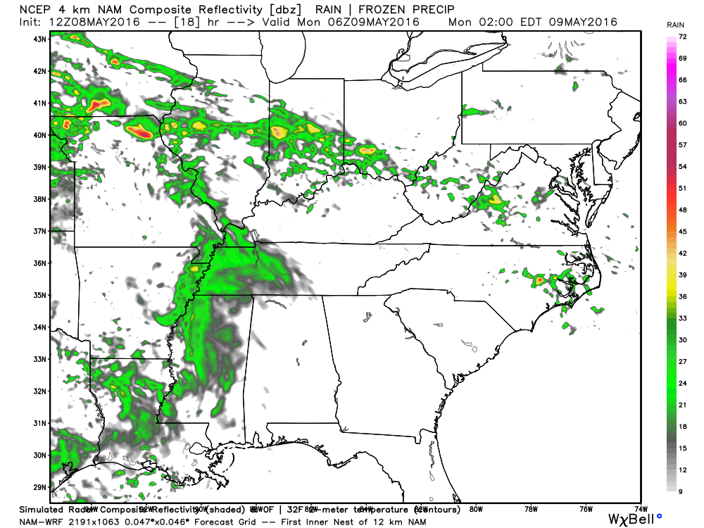
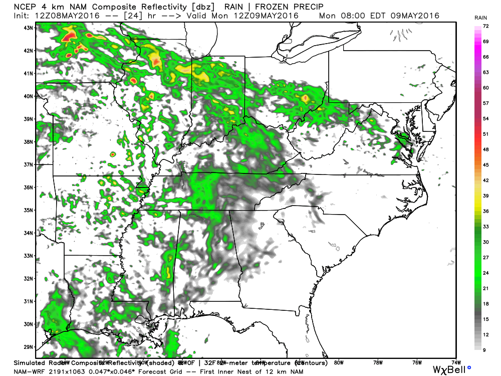
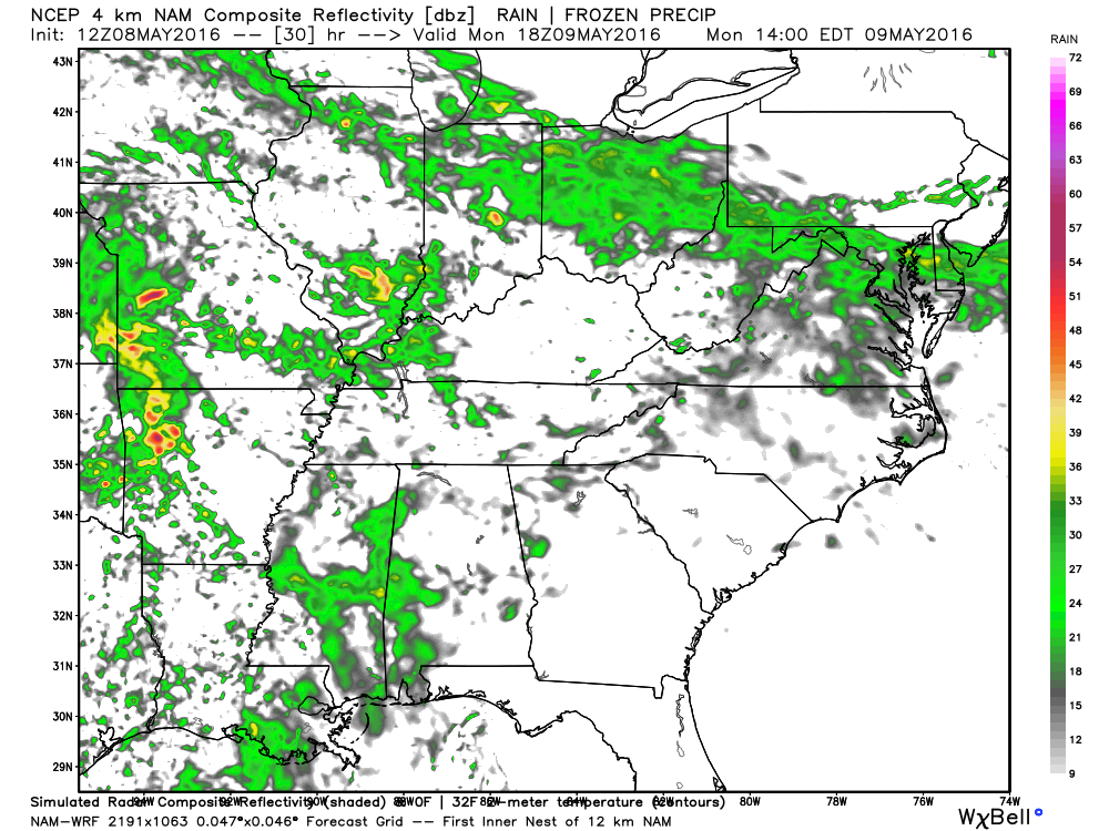
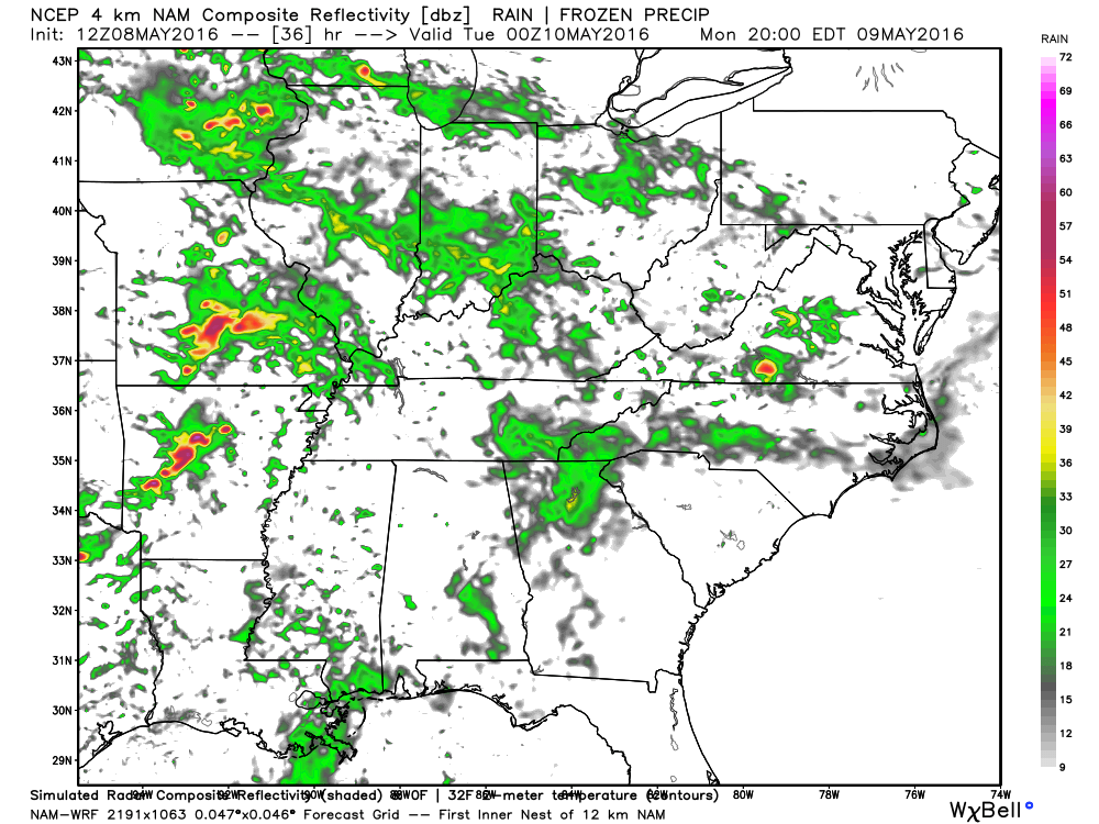
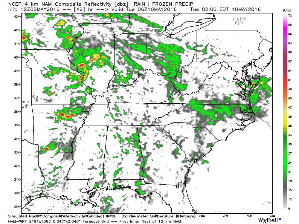
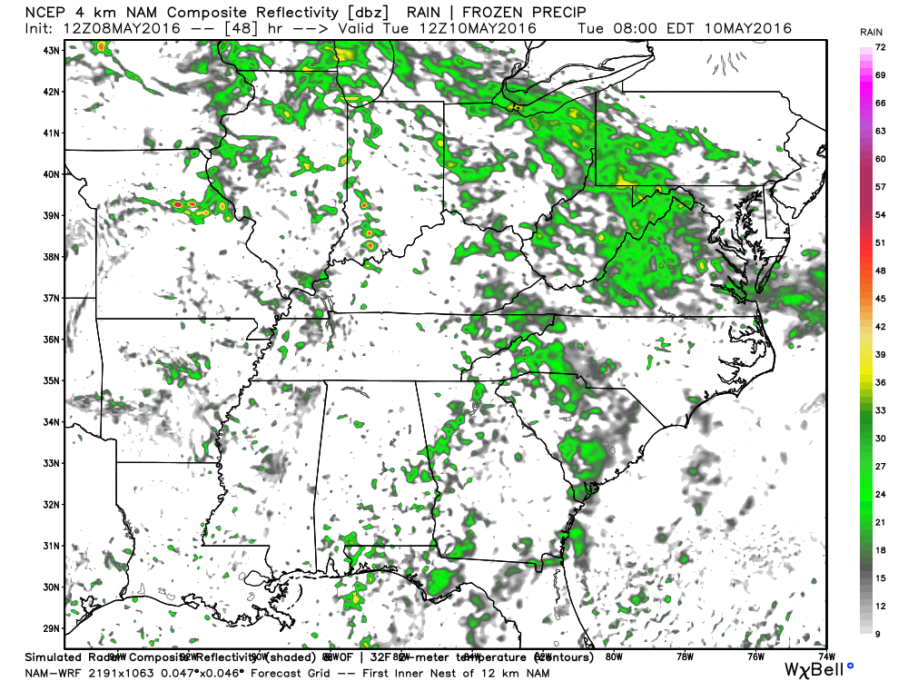
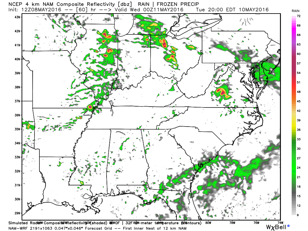
Let me show you the WRF guidance from weatherbell. com. These are future-cast radar images. This won’t be exact. But, it will give you at least an idea of what might occur on Monday and Tuesday.
This first image is for 1 AM on Monday morning. Scattered showers in the region. Maybe a rumble of thunder.
This next image is for 7 am on Monday morning. Scattered showers and thunderstorms possible.
This next image is for 1 pm on Monday afternoon. Again, some green in our region.
This next image is for Monday evening at 7 pm. Notice the red colors in Missouri. Perhaps some heavier storms.
This next image is for 1 AM on Tuesday morning. Scattered strong storms possible in the area.
This next image is for 7 AM on Tuesday morning. A few showers possible.
This next image is for 7 PM on Tuesday evening. Some storms possible. Maybe some strong storms. Lower confidence on severe weather Tuesday.
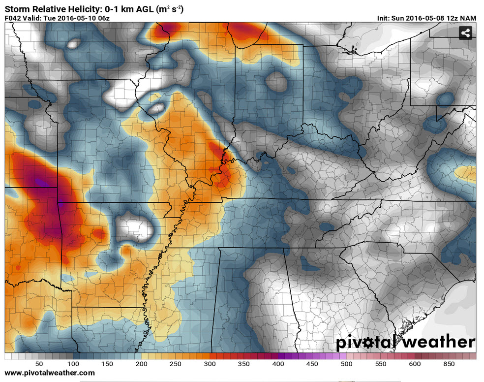
We will have wind shear on Monday night. And, that means some storms could be intense. Damaging winds and hail possible. Here is the helicity map for Monday night.
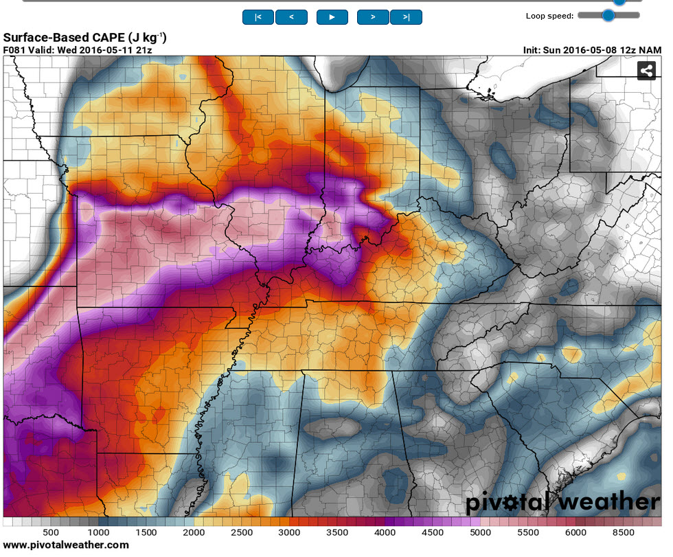
CAPE values will be highest on Wednesday. CAPE is a measure of how unstable the atmosphere is. High CAPE means plenty of energy for thunderstorms. CAPE readings on Wednesday could top 3000.

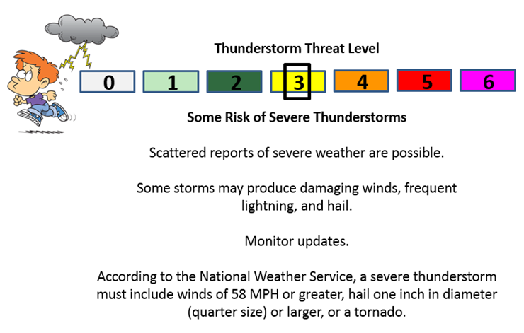
Can we expect severe thunderstorms over the next 24 to 48 hours? Remember that a severe thunderstorm is defined as a thunderstorm that produces 58 mph winds or higher, quarter size hail or larger, and/or a tornado.
.
A level THREE severe weather threat will be with us on Monday through Wednesday night. There could be periods of time when the threat level will need to be raised.
Main thing to take from this forecast is monitor updates.
Sunday night – A few sub-severe storms are possible.
Monday morning and afternoon: Some storms are possible. Most likely below severe levels.
Monday night: Strong to potentially severe storms are possible. Monitor updates.
Tuesday and Tuesday night: Strong to potentially severe storms are possible. Monitor updates.
Wednesday morning: Severe storms are not anticipated
Wednesday afternoon and night: Severe storms are possible. Monitor updates.
Thursday: Severe storms are not anticipated
Friday: Severe storms are not anticipated.
Saturday and Sunday: Severe storms are not anticipated.
.

.
..
Main updates were to temperatures.
.

.
Several concerns for the coming days. Locally heavy rain is possible with thunderstorms on Monday – Wednesday night.
Severe thunderstorms are certainly possible this week. I will be watching Monday afternoon and night for southeast Missouri. Whether severe weather is a concern for the rest of the area is still a question. Heavy rain is possible area-wide on Monday night.
Tuesday and Tuesday night will provide the opportunity for additional showers and thunderstorms. Again, locally heavy rain and severe storms are possible.
I am concerned about Wednesday afternoon and night. Heavy rain possible. Severe storms are certainly possible. Monitor updates.
.


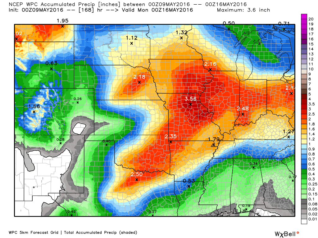
How much precipitation should we expect over the next few days?
A long week of weather ahead of us. Several rounds of potentially heavy rain. Placement of features will be key to your rainfall totals. Remember, thunderstorms can produce locally higher totals. And, that will certainly be the case this week. I would not be a bit surprised if someone tops three inches of rain over the coming days. Possibly more.

Here are the current river stage forecasts. You can click your state and then the dot for your location. It will bring up the full forecast and hydrograph.
.
.

Here is the official 6-10 day and 8-14 day temperature and precipitation outlook. Check the date stamp at the top of each image (so you understand the time frame).
The forecast maps below are issued by the Weather Prediction Center (NOAA).


The latest 8-14 day temperature and precipitation outlook. Note the dates are at the top of the image. These maps DO NOT tell you how high or low temperatures or precipitation will be. They simply give you the probability as to whether temperatures or precipitation will be above or below normal.


Who do you trust for your weather information and who holds them accountable?
I have studied weather in our region since the late 1970’s. I have 37 years of experience in observing our regions weather patterns. My degree is in Broadcast Meteorology from Mississippi State University and an Associate of Science (AS). I am currently working on my Bachelor’s Degree in Geoscience.
My resume includes:
Member of the American Meteorological Society.
NOAA Weather-Ready Nation Ambassador.
Meteorologist for McCracken County Emergency Management. I served from 2005 through 2015.
I own and operate the Southern Illinois Weather Observatory.
Recipient of the Mark Trail Award, WPSD Six Who Make A Difference Award, Kentucky Colonel, and the Caesar J. Fiamma” Award from the American Red Cross.
In 2009 I was presented with the Kentucky Office of Highway Safety Award.
Recognized by the Kentucky House of Representatives for my service to the State of Kentucky leading up to several winter storms and severe weather outbreaks.
I am also President of the Shadow Angel Foundation which serves portions of western Kentucky and southern Illinois.
There is a lot of noise on the internet. A lot of weather maps are posted without explanation. Over time you should learn who to trust for your weather information.
My forecast philosophy is simple and straight forward.
- Communicate in simple terms
- To be as accurate as possible within a reasonable time frame before an event
- Interact with you on Twitter, Facebook, and the blog
- Minimize the “hype” that you might see on television or through other weather sources
- Push you towards utilizing wall-to-wall LOCAL TV coverage during severe weather events
I am a recipient of the Mark Trail Award, WPSD Six Who Make A Difference Award, Kentucky Colonel, and the Caesar J. Fiamma” Award from the American Red Cross. In 2009 I was presented with the Kentucky Office of Highway Safety Award. I was recognized by the Kentucky House of Representatives for my service to the State of Kentucky leading up to several winter storms and severe weather outbreaks.
If you click on the image below you can read the Kentucky House of Representatives Resolution.

Many of my graphics are from www.weatherbell.com – a great resource for weather data, model data, and more


You can sign up for my AWARE email by clicking here I typically send out AWARE emails before severe weather, winter storms, or other active weather situations. I do not email watches or warnings. The emails are a basic “heads up” concerning incoming weather conditions.