WeatherTalk monthly operating costs can top $2000.00. Your $3 subscription helps pay for those costs. I work for you.
For $3 a month you can receive the following. You may choose to receive these via your WeatherTalk app or regular text messaging.
- Severe weather app/text alerts from my keyboard to your app/cell phone. These are hand typed by Beau. During tornado outbreaks, you will receive numerous app/text messages telling you exactly where the tornado is located.
- Daily forecast app/texts from my computer to your app/cell phone.
- Social media links sent directly to your app/cell phone. When I update the blog, videos, or Facebook you will receive the link.
- AWARE emails. These emails keep you well ahead of the storm. They give you several days of lead time before significant weather events.
- Direct access to Beau via text and email. Your very own personal meteorologist. I work for you!
- Missouri and Ohio Valley centered video updates
- Long-range weather videos
- Week one, two, three and four temperature and precipitation outlooks.
- Monthly outlooks.
- Your subscription also will help support several local charities.
Haven’t you subscribed? Subscribe at www.beaudodsonweather.com

Example of a recent severe weather alert. I issued this well before the official tornado warning. You would have had plenty of time for you and your family to seek shelter.


Your $3 per month also helps support these local charity projects.

I encourage subscribers to use the app vs regular text messaging. We have found text messaging to be delayed during severe weather. The app typically will receive the messages instantly. I recommend people have three to four methods of receiving their severe weather information.
Remember, my app and text alerts are hand typed and not computer generated. You are being given personal attention during significant weather events.

WWW.WEATHERTALK.COM subscribers, here is my day to day schedule for your weather products.


May 8, 2018
Tuesday Forecast Details
Forecast: Mostly sunny.
Temperatures: MO ~ 77 to 82 IL ~ 77 to 82 KY ~ 78 to 82 TN ~ 78 to 82
What is the chance of precipitation? MO ~ 0% IL ~ 0% KY ~ 0% TN ~ 0%
Coverage of precipitation: None
Winds: East and southeast at 5 to 10 mph
What impacts are anticipated from the weather? None
My confidence in the forecast verifying: High
Is severe weather expected? No
The NWS defines severe weather as 58 mph wind or great, 1″ hail or larger, and/or tornadoes
Should I cancel my outdoor plans? No
Sunrise: 5:52 AM
Tuesday Night Forecast Details:
Forecast: Increasing clouds as the night wears on. A chance of a few showers and thunderstorms. Best chances would be over southeast Missouri and southwest Illinois.
Temperatures: MO ~ 56 to 60 IL ~ 54 to 58 KY ~ 54 to 56 TN ~ 56 to 60
What is the chance of precipitation? MO ~ 30% IL ~ 30% KY ~ 20% TN ~ 20%
Coverage of precipitation: Scattered late
Winds: East and southeast at 5 to 10 mph with higher gusts late
What impacts are anticipated from the weather? Wet roadways after midnight. Lightning.
My confidence in the forecast verifying: High
Is severe weather expected? No
The NWS defines severe weather as 58 mph wind or great, 1″ hail or larger, and/or tornadoes
Should I cancel my outdoor plans? No
Sunset: 7:49 PM
May 9, 2018
Wednesday Forecast Details
Forecast: Breezy. A mix of sun and clouds. A chance of thunderstorms. Some storms could be strong. The risk of severe weather is not zero. Questions remain on instability and rain coverage. Some areas may remain dry.
Temperatures: MO ~ 82 to 86 IL ~ 82 to 85 KY ~ 82 to 85 TN ~ 80 t2 85
What is the chance of precipitation? MO ~ 30% IL ~ 30% KY ~ 30% TN ~ 30%
Coverage of precipitation: Scattered
Winds: South 15 to 30 mph with higher gusts
What impacts are anticipated from the weather? Wet roads. Lightning. Monitor the hail and strong wind threat.
My confidence in the forecast verifying: Medium
Is severe weather expected? Some storms could be intense with hail and strong winds. Monitor updates.
The NWS defines severe weather as 58 mph wind or great, 1″ hail or larger, and/or tornadoes
Should I cancel my outdoor plans? No, but monitor updated forecasts and radars.
Sunrise: 5:51 AM
Wednesday Night Forecast Details:
Forecast: Breezy. Cloudy. Scattered showers and thunderstorms. Monitor the risk of strong storms.
Temperatures: MO ~ 62 to 66 IL ~ 62 to 65 KY ~ 62 to 65 TN ~ 62 to 66
What is the chance of precipitation? MO ~ 30% IL ~ 30% KY ~ 30% TN ~ 30%
Coverage of precipitation: Scattered
Winds: South and southwest at 10 to 20 mph with higher gusts
What impacts are anticipated from the weather? Wet roadways. Lightning. Monitor the risk of hail and strong winds.
My confidence in the forecast verifying: Medium
Is severe weather expected? Monitor updates. Some storms could be strong.
The NWS defines severe weather as 58 mph wind or great, 1″ hail or larger, and/or tornadoes
Should I cancel my outdoor plans? No, but monitor updates and radars.
Sunset: 7:51 PM
May 10, 2018
Thursday Forecast Details
Forecast: Breezy. Partly sunny. Quite warm. A chance of widely scattered thunderstorms.
Temperatures: MO ~ 84 to 88 IL ~ 84 to 88 KY ~ 84 to 88 TN ~ 84 to 88
What is the chance of precipitation? MO ~ 20% IL ~ 20% KY ~ 20% TN ~ 20%
Coverage of precipitation: Isolated
Winds: Southwest at 7 to 14 mph with higher gusts
What impacts are anticipated from the weather? Wet roadways. Lightning. Monitor the risk of strong thunderstorms.
My confidence in the forecast verifying: Medium
Is severe weather expected? If thunderstorms form they could produce isolated hail and strong winds
The NWS defines severe weather as 58 mph wind or great, 1″ hail or larger, and/or tornadoes
Should I cancel my outdoor plans? No, but monitor updates and check radars.
Sunrise: 5:50 AM
Thursday Night Forecast Details:
Forecast: Partly cloudy and mild. A chance of scattered thunderstorms.
Temperatures: MO ~ 60 to 65 IL ~ 60 to 65 KY ~ 60 to 65 TN ~ 60 to 65
What is the chance of precipitation? MO ~ 30% IL ~ 30% KY ~ 30% TN ~ 30%
Coverage of precipitation: Isolated to scattered
Winds: South and southwest at 5 to 10 mph
What impacts are anticipated from the weather? Wet roadways. Lightning. Monitor the risk of strong thunderstorms.
My confidence in the forecast verifying: Medium
Is severe weather expected? If thunderstorms form they could produce isolated hail and strong winds
The NWS defines severe weather as 58 mph wind or great, 1″ hail or larger, and/or tornadoes
Should I cancel my outdoor plans? No, but check updated forecasts and radars.
Sunset: 7:51 PM
May 11, 2018
Friday Forecast Details
Forecast: Mostly sunny. Quite warm. Some cumulus clouds.
Temperatures: MO ~ 84 to 88 IL ~ 84 to 88 KY ~ 84 to 88 TN ~ 84 to 88
What is the chance of precipitation? MO ~ 10% IL ~ 10% KY ~ 10% TN ~ 10%
Coverage of precipitation: None to isolated
Winds: South at 5 to 10 mph with gusts to 15 mph
What impacts are anticipated from the weather? Most likely none. Isolated lightning and wet roadways.
My confidence in the forecast verifying: Medium
Is severe weather expected? If thunderstorms form they could produce isolated hail and strong winds
The NWS defines severe weather as 58 mph wind or great, 1″ hail or larger, and/or tornadoes
Should I cancel my outdoor plans? No
Sunrise: 5:49 AM
Friday Night Forecast Details:
Forecast: Mostly clear. A few late night clouds over our northern counties. Mild.
Temperatures: MO ~ 64 to 68 IL ~ 64 to 68 KY ~ 64 to 68 TN ~ 64 to 68
What is the chance of precipitation? MO ~ 10% IL ~ 10% KY ~ 10% TN ~ 10%
Coverage of precipitation: Isolated lightning and wet roadways.
Winds: South at 5 to 10 mph with gusts to 12 mph
What impacts are anticipated from the weather? Most likely none. Isolated lightning and wet roadways.
My confidence in the forecast verifying: Medium
Is severe weather expected? If thunderstorms form they could produce isolated hail and strong winds
The NWS defines severe weather as 58 mph wind or great, 1″ hail or larger, and/or tornadoes
Should I cancel my outdoor plans? No
Sunset: 7:52 PM
May 12, 2018
Saturday Forecast Details
Forecast: Mostly sunny. Some afternoon cumulus clouds. Very warm.
Temperatures: MO ~ 84 to 88 IL ~ 84 to 88 KY ~ 84 to 88 TN ~ 84 to 88
What is the chance of precipitation? MO ~ 10% IL ~ 10% KY ~ 10% TN ~ 10%
Coverage of precipitation: Most likely none. Isolated if anything at all.
Winds: South at 5 to 10 mph with gusts to 15 mph
What impacts are anticipated from the weather? Most likely none. Isolated lightning and wet roadways.
My confidence in the forecast verifying: Medium
Is severe weather expected? If thunderstorms form they could produce isolated hail and strong winds
The NWS defines severe weather as 58 mph wind or great, 1″ hail or larger, and/or tornadoes
Should I cancel my outdoor plans? No, but check radars in the afternoon
Sunrise: 5:48 AM
Saturday Night Forecast Details:
Forecast: Mostly clear. A few passing clouds.
Temperatures: MO ~ 64 to 68 IL ~ 64 to 68 KY ~ 64 to 68 TN ~ 64 to 68
What is the chance of precipitation? MO ~ 5% IL ~ 5% KY ~ 5% TN ~ 5%
Coverage of precipitation: None to isolated
Winds: South at 7 to 14 mph
What impacts are anticipated from the weather? Most likely none. Isolated lightning and wet roadways.
My confidence in the forecast verifying: Medium
Is severe weather expected? If thunderstorms form they could produce isolated hail and strong winds
The NWS defines severe weather as 58 mph wind or great, 1″ hail or larger, and/or tornadoes
Should I cancel my outdoor plans? No, but check evening radars
Sunset: 7:43 PM
May 13, 2018
Sunday Forecast Details
Forecast: Partly sunny. A chance of an afternoon thunderstorm.
Temperatures: MO ~ 83 to 86 IL ~ 83 to 86 KY ~ 83 to 86 TN ~ 83 to 86
What is the chance of precipitation? MO ~ 10% IL ~ 10% KY ~ 10% TN ~ 10%
Coverage of precipitation: Most likely none. Isolated if anything.
Winds: South and southwest at 6 to 12 mph
What impacts are anticipated from the weather? Most likely none. Isolated lightning and wet roadways.
My confidence in the forecast verifying: Medium
Is severe weather expected? If thunderstorms form they could produce isolated hail and strong winds
The NWS defines severe weather as 58 mph wind or great, 1″ hail or larger, and/or tornadoes
Should I cancel my outdoor plans? No, but check afternoon radars
Sunrise: 5:48 AM
Sunday Night Forecast Details:
Forecast: Partly cloudy. A chance of a thunderstorm.
Temperatures: MO ~ 60 to 65 IL ~ 62 to 66 KY ~ 64 to 68 TN ~ 64 to 68
What is the chance of precipitation? MO ~ 30% IL ~ 30% KY ~ 30% TN ~ 30%
Coverage of precipitation: Scattered
Winds: Southwest and west at 6 to 12 mph
What impacts are anticipated from the weather? Wet roadways. Lightning.
My confidence in the forecast verifying: Medium
Is severe weather expected? If thunderstorms form they could produce isolated hail and strong winds
The NWS defines severe weather as 58 mph wind or great, 1″ hail or larger, and/or tornadoes
Should I cancel my outdoor plans? No, but monitor updates
Sunset: 7:53 PM
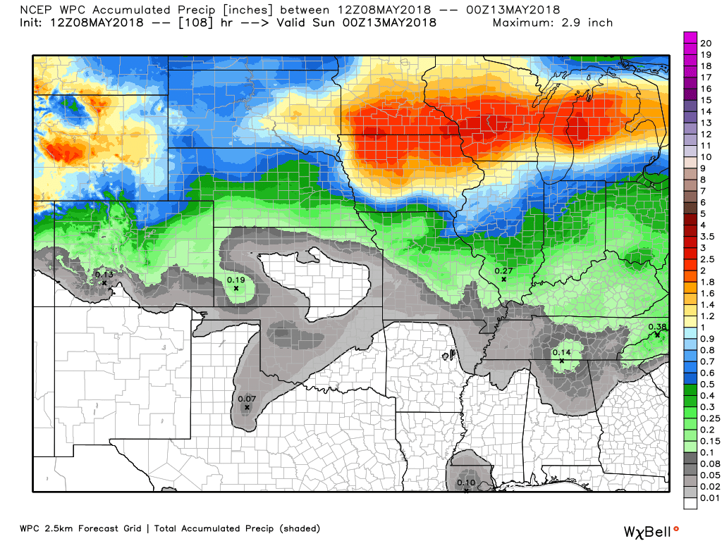
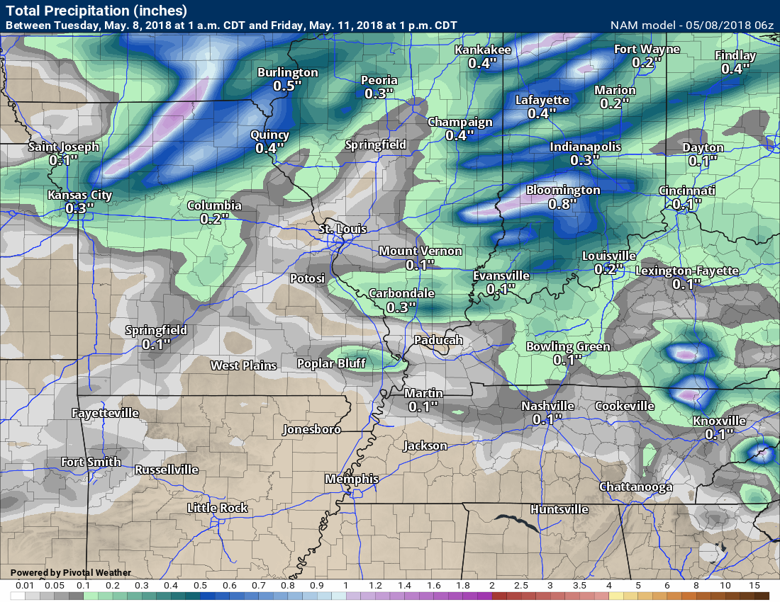
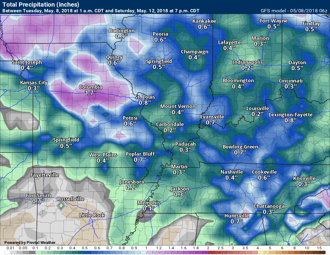
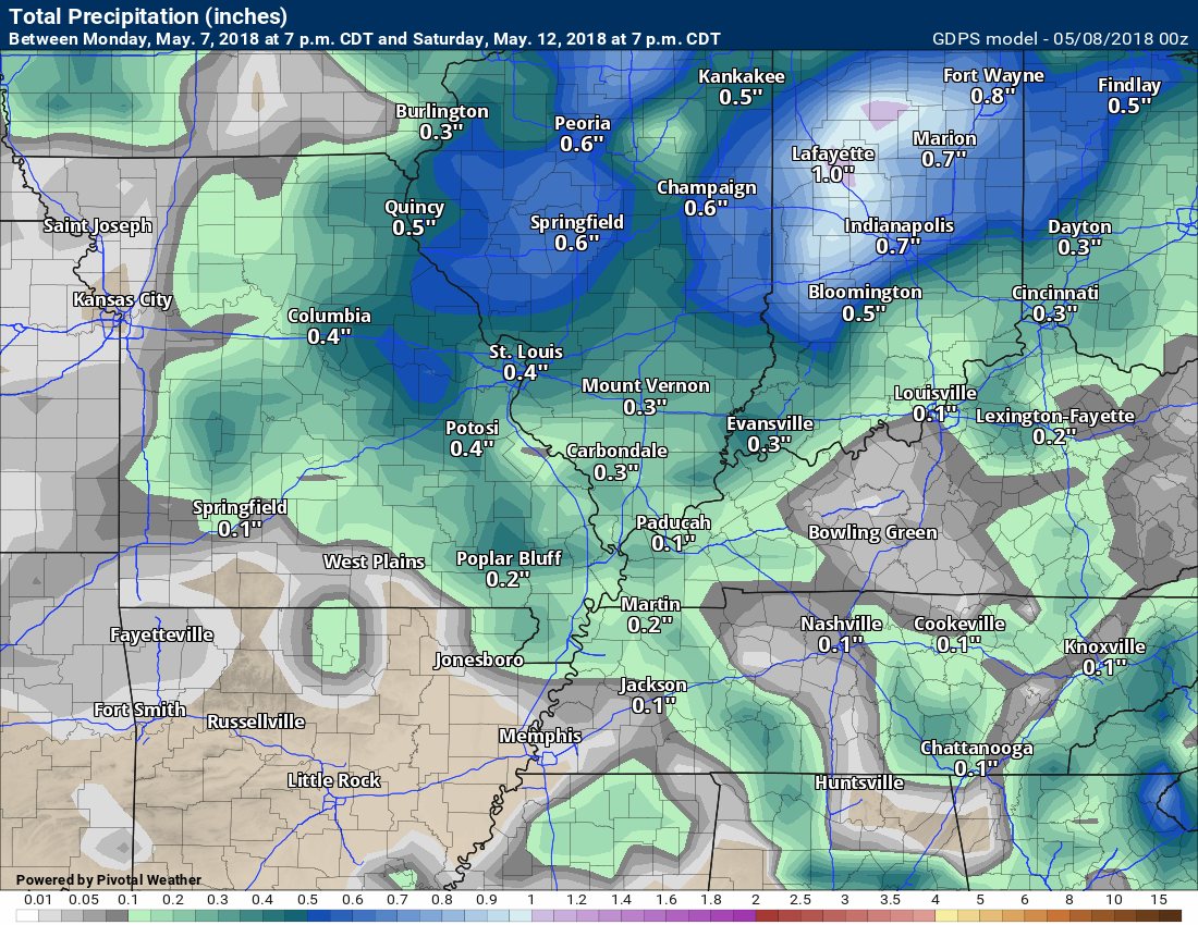
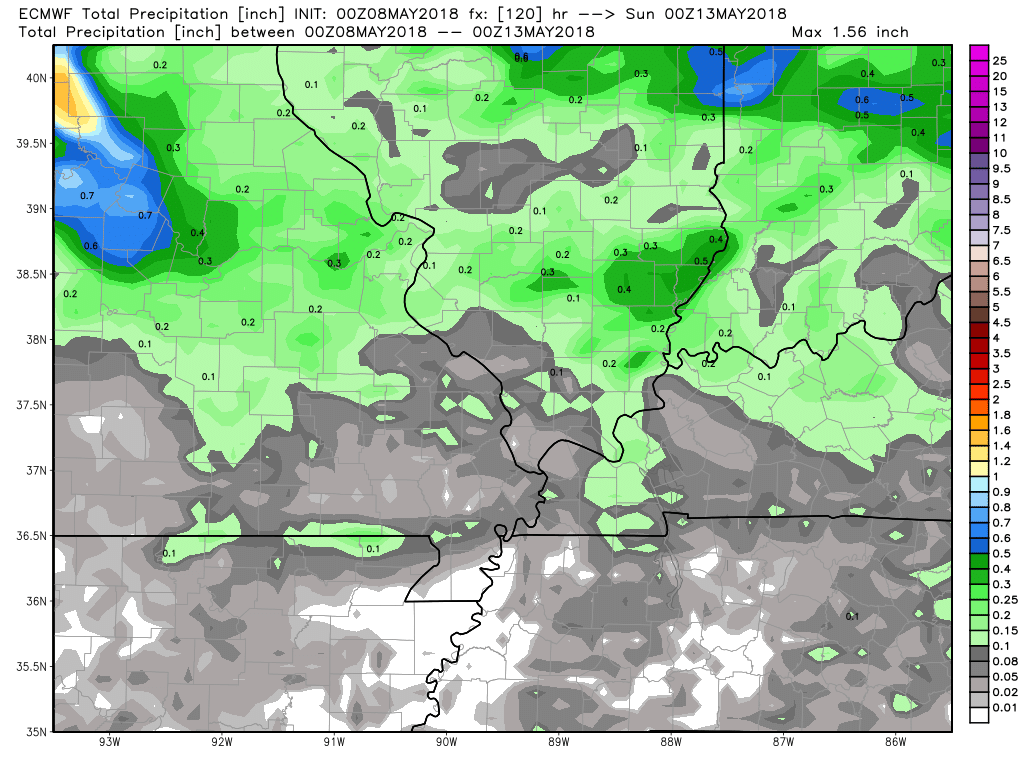
RAIN TOTALS
WPC/NOAA rain forecast
NAM 3K high-resolution model.
GFS model guidance
Canadian model guidance through Sunday
EC model guidance through Sunday

Interactive Radars:
Interactive live weather radar page. Choose the city nearest your location. If one of the city radars won’t load then try a nearby one. Click here.

Questions? Broken links? Other?
You may email me at beaudodson@usawx.com

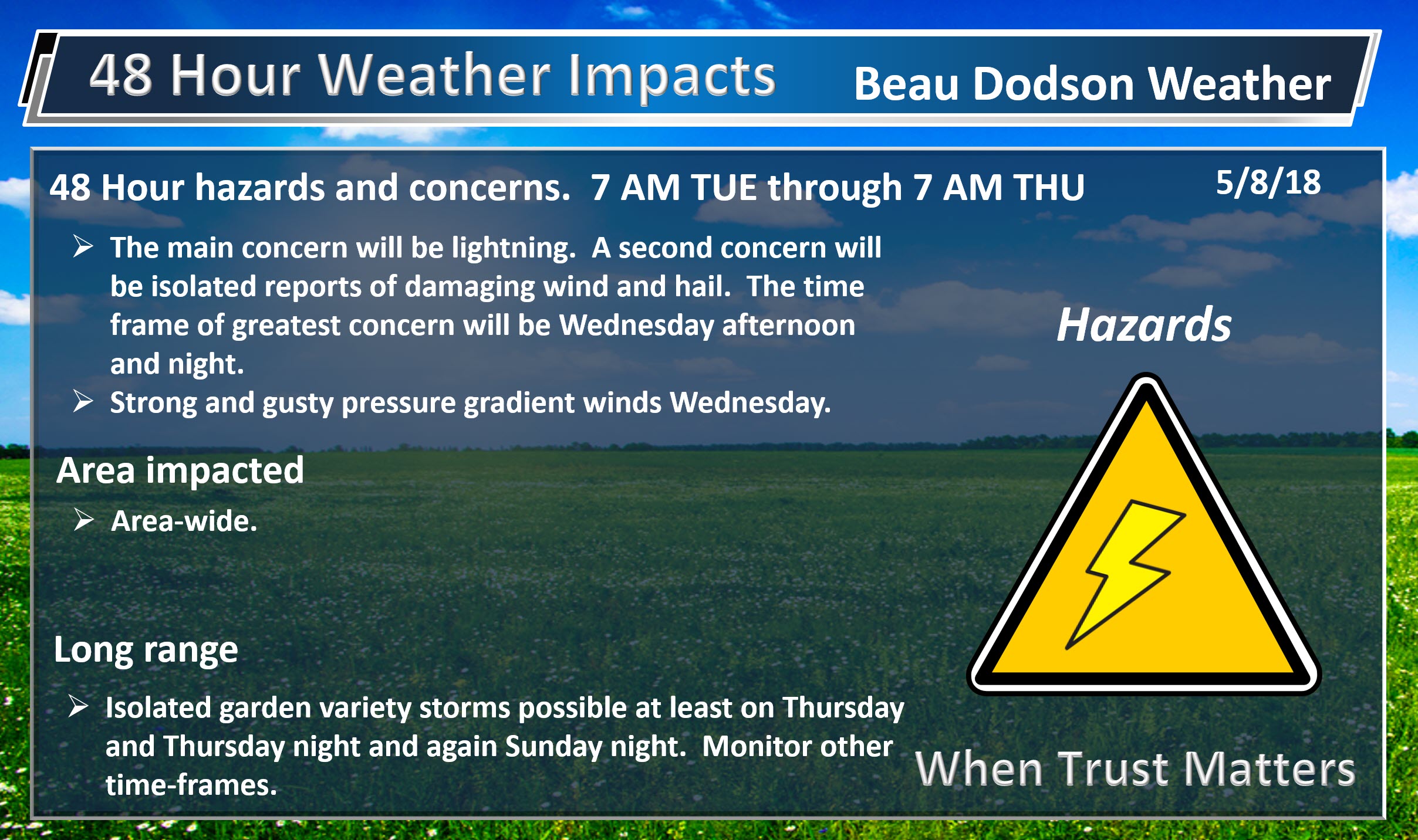
The National Weather Service defines a severe thunderstorm as one that produces quarter size hail or larger, 58 mph winds or greater, and/or a tornado.
Tuesday through Tuesday night: Severe weather is not anticipated. Lightning is possible late Tuesday night.
Wednesday through Thursday night: Thunderstorms are possible. A few of the thunderstorms could produce hail and gusty winds. The tornado threat currently appears low. Monitor updates.
Friday through Sunday: Severe weather is not anticipated. I can’t completely rule out an isolated thunderstorm. If a storm were to develop it could be intense. Organized severe weather appears unlikely.
![]()
Interactive live weather radar page. Choose the city nearest your location. If one of the cities does not work then try a nearby one. Click here.
National map of weather watches and warnings. Click here.
Storm Prediction Center. Click here.
Weather Prediction Center. Click here.

Live lightning data: Click here.

Interactive GOES R satellite. Track clouds. Click here.

Here are the latest local river stage forecast numbers Click Here.
Here are the latest lake stage forecast numbers for Kentucky Lake and Lake Barkley Click Here.

The spring and preliminary summer outlooks have been posted for subscribers. Scroll down to see the outlook.
Not a subscriber? Learn more at this link.

Weather Headlines
- Quite warm weather to continue into next week.
- Monitoring thunderstorm chances late tonight into Thursday night.
- For the most part, Friday into Sunday appears dry. Isolated thunderstorm risk.
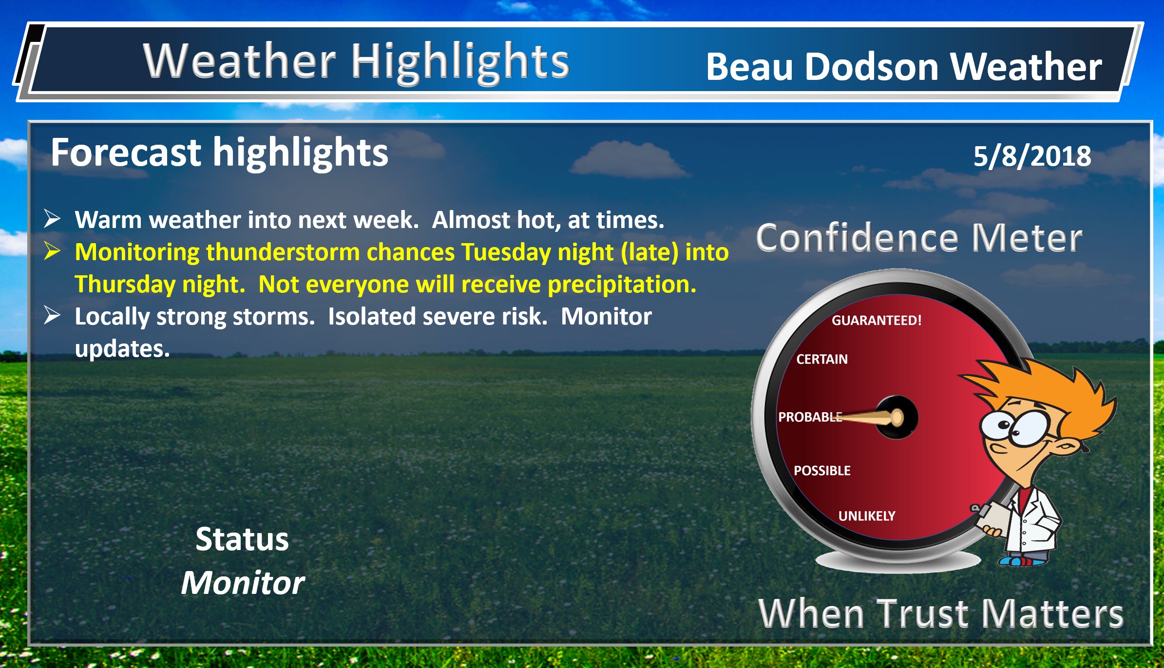
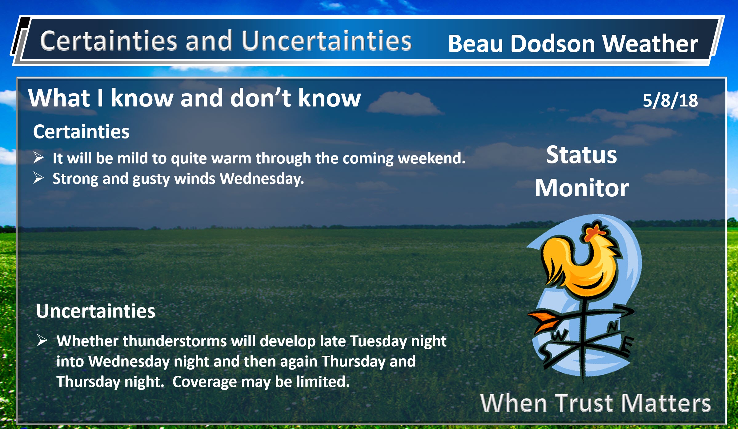
I hope everyone is ready for warm temperatures. They have arrived! Numerous locations will rise into the 80’s today through at least Sunday. Some areas may even approach 90 degrees. Hard to believe. It seems it took spring forever to arrive.
Thursday through Sunday will deliver middle to upper 80’s for the region. Some of you might even consider this hot! I try to reserve hot for 90 degrees and above. Either way, it will feel like summer.
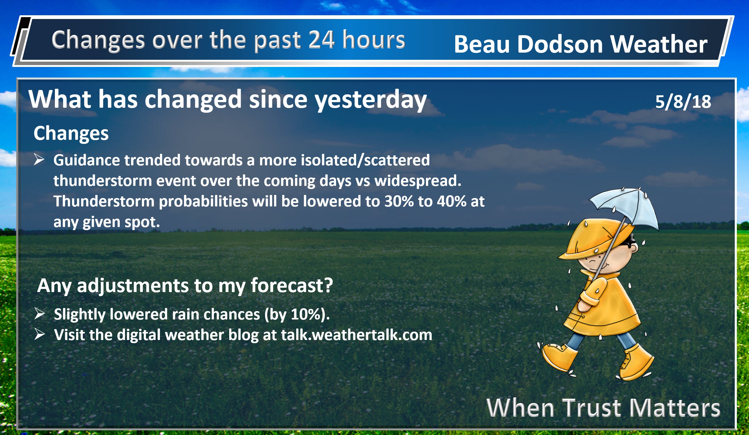
A weak cold front will push into the region Wednesday into Thursday. This will be a slow-moving front. The Gulf of Mexico is not open for business. That means that moisture will be somewhat limited. There are questions as to whether thunderstorms will even form in our region. For now, I have shower and thunderstorm chances increasing late tonight from the west and north. Those precipitation chances will continue on/off into at least Thursday night.
I can not find a time period of organized/widespread thunderstorm activity.
We do have some peak time-frames for rain. That would mostly be late tonight into early tomorrow morning and then Wednesday afternoon and night.
IF thunderstorms form, they could produce locally heavy rain, gusty winds, and even a report or two of hail. There is a low end risk of a severe thunderstorm warning or two. Widespread severe weather appears unlikely from this thunderstorm event.
Additional thunderstorms are possible Thursday afternoon and night. Isolated to scattered.
Whether any storms form, during the heat of the day, Friday into Sunday is questionable. I did include a 10% chance each day. Almost like summer. During the summer months, we can have daily afternoon thunderstorm chances. Most areas remain dry and a few are soaked with heavy downpours and gusty winds.
In addition to the rain chances, this cold front will deliver some strong and gusty gradient winds. Gradient winds are caused by tight pressure gradients. High and low pressure. Winds may gust above 40 mph Wednesday.
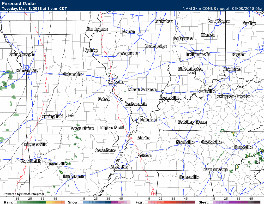
Future-cast radar from the 3K NAM model guidance. Notice the timestamp in the upper left portion of the screen.
This won’t be exact. This is a models opinion of what radar might look like. Take the general idea from it. We will have some chance of scattered showers and thunderstorm late tonight into Wednesday night. Perhaps a peak in activity late tonight for portions of the region and then again Wednesady afternoon and night.
![]()

WeatherBrains Episode 641
Weather Brains is a weekly podcast/video for those who love weather and want more!
Joining us for this episode is SPC Lead Forecaster John Hart. John is actually in the mountains of Colorado where he has been panning for gold. As far back as he can remember, he had always dreamed of being a lead forecaster for the SELS unit in Kansas City which is now called the SPC. After attending college in St. Louis, he worked at Channel 2 there for a while. Then, a few weeks after graduation he was lucky enough to get a job at the National Weather Service in Charleston, West Virginia, and interned there for two years. He was involved with a few computer programming projects there that got his name known, so when a job opened at SELS, he was able to get it. Since then, he’s been in this unit, but worked multiple jobs. He became a meso-forecaster in 1995, and then a lead forecaster in 2000.
John considers the events of April 27, 2011, to be the biggest event that he will experience in his career. But the show title comes from a comment John made about how no event is a slam dunk, there are always uncertainties in any weather event.
Other discussions in this weekly podcast include topics like:
- Extremes: 103 at Rio Grande Village, TX, and 19 at Rosscommon, MI
- Severe weather forecast Central US next couple of days
- Hail and high wind from West TX to NB today
Previous episodes can be viewed by clicking here.

We offer interactive local city live radars and regional radars. If a radar does not update then try another one. If a radar does not appear to be refreshing then hit Ctrl F5. You may also try restarting your browser.
The local city view radars also have clickable warnings.
During the winter months, you can track snow and ice by clicking the winterize button on the local city view interactive radars.
You may email me at beaudodson@usawx.com
Find me on Facebook!

Find me on Twitter!

Did you know that a portion of your monthly subscription helps support local charity projects?
You can learn more about those projects by visiting the Shadow Angel Foundation website and the Beau Dodson News website.

I encourage subscribers to use the app vs regular text messaging. We have found text messaging to be delayed during severe weather. The app typically will receive the messages instantly. I recommend people have three to four methods of receiving their severe weather information.
Remember, my app and text alerts are hand typed and not computer generated. You are being given personal attention during significant weather events.
