We have some great sponsors for the Weather Talk Blog. Please let our sponsors know that you appreciate their support for the Weather Talk Blog.
Milner and Orr Funeral Home and Cremation Services located in Paducah, Kentucky and three other western Kentucky towns – at Milner and Orr they believe in families helping families. You can find Milner and Orr on Facebook, as well.
![]()

This forecast update covers far southern Illinois, far southeast Missouri, and far western Kentucky. See the coverage map on the right side of the blog.
Remember that weather evolves. Check back frequently for updates, especially during active weather.
The forecast numbers below may vary quite a bit across the region. These are the averages.
With this type of pattern I can’t rule out a stray shower or thunderstorm in the region. But, no organized precipitation is forecast until late in the week. Just keep in mind…there could be a shower or storm popup. Isolated in nature.
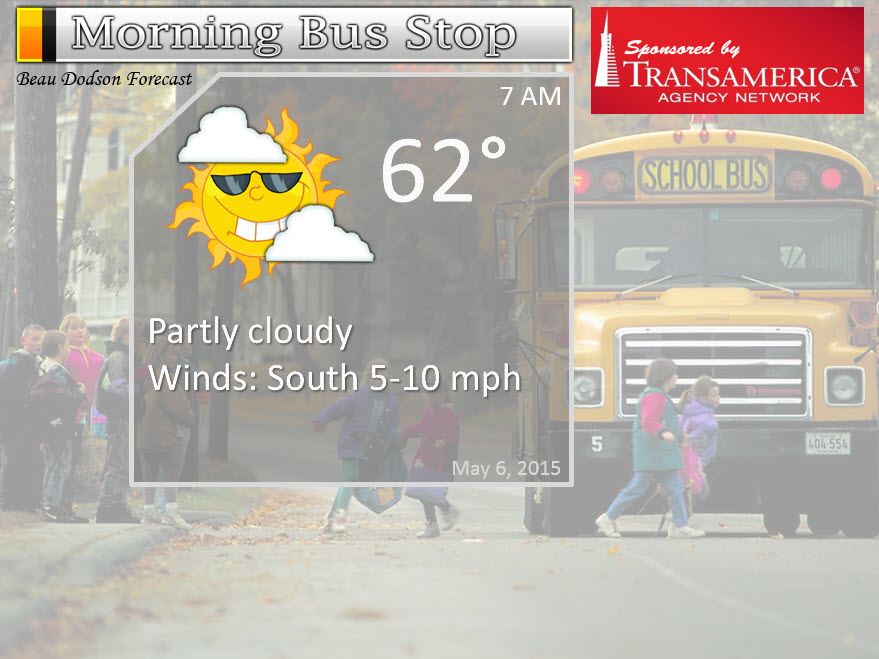
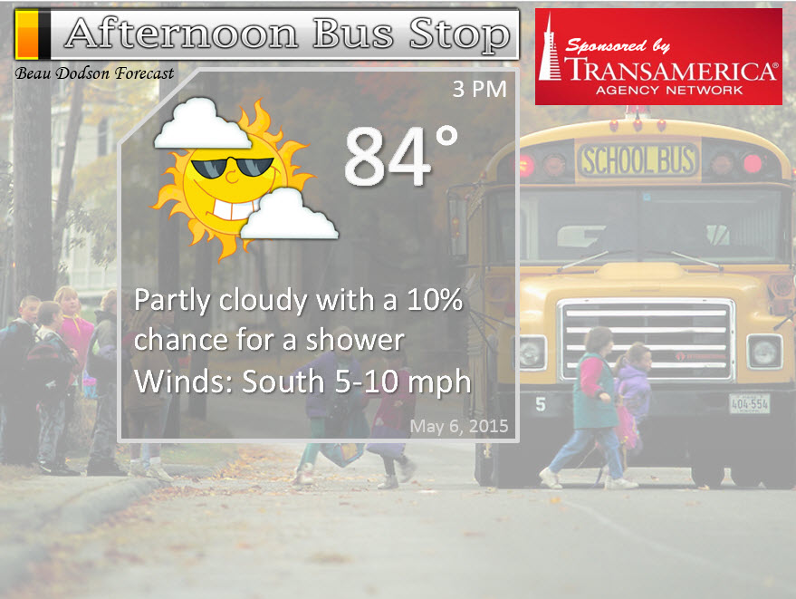
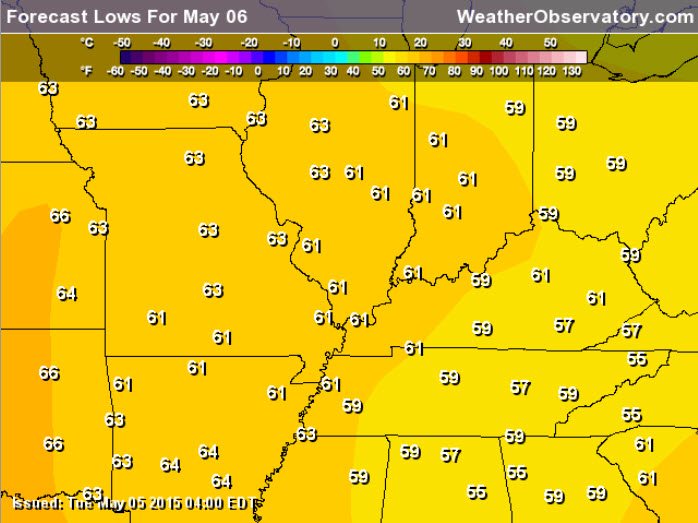
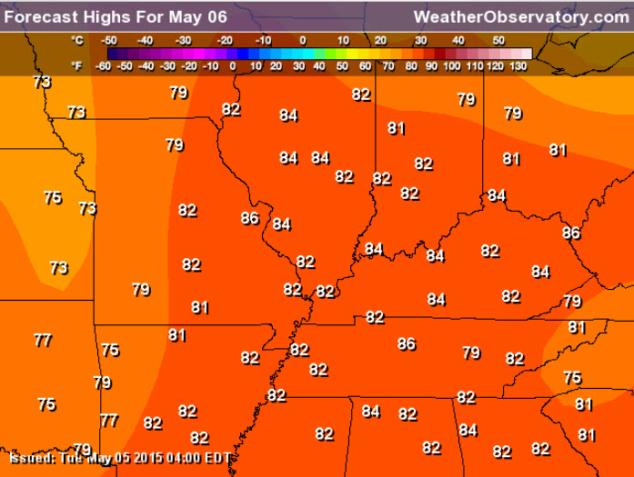
Wednesday – Partly sunny and warm. A very slight chance for a pop-up thunderstorm (less than 20%). High temperatures will be in the lower to middle 80’s. Winds southerly at 10-15 mph.
My confidence in this part of the forecast verifying is high
Should I cancel my outdoor plans? No reason to cancel plans
Wednesday night – Partly cloudy and mild. Lows in the lower 60’s. Southwest winds at 10 mph.
My confidence in this part of the forecast verifying is high
Should I cancel my outdoor plans? No reason to cancel plans
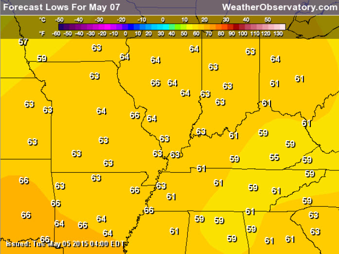
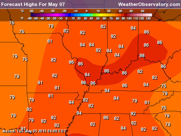
Thursday – Partly sunny and warm. A very slight chance for precipitation (less than 20%). High temperatures will be in the lower to middle 80’s. Winds southerly at 10-15 mph.
My confidence in this part of the forecast verifying is high
Should I cancel my outdoor plans? No reason to cancel plans
Thursday night – Partly to mostly cloudy and mild. Slight chance for a scattered shower or thunderstorm…especially western counties in southeast Missouri. Lows mostly in the lower 60’s. Southwest winds at 10 mph.
My confidence in this part of the forecast verifying is high
Should I cancel my outdoor plans? No reason to cancel plans
Friday – Partly cloudy. Quite a few clouds. Warm and humid. A chance for widely scattered showers and thunderstorms (right now at any given location I would put the chance at 30%). Some questions on the timing of a disturbance coming out of the southwest/west. High temperatures will be in the lower to middle 80’s. Winds southerly at 10-15 mph.
My confidence in this part of the forecast verifying is high
Should I cancel my outdoor plans? No reason to cancel plans, but monitor updates in case the disturbance coming in from the west arrives sooner than expected.
Saturday and Sunday – depending on the placement of a disturbance moving in from the west we will likely have some shower and thunderstorm activity in the region. The question is coverage. If you have outdoor plans then at least have a plan B in the back of your mind.
![]()
![]()
Sunrise and Sunset Times – Click Here

The School Bus Stop Forecast is sponsored by TransAmerica Agency Network Paducah District – you can visit their Facebook page here and their home page here
Current Temperatures Around The Local Area


Don’t forget to check out the Southern Illinois Weather Observatory web-site for weather maps, tower cams, scanner feeds, radars, and much more! Click here

An explanation of what is happening in the atmosphere over the coming days…
Highlights
1. It feels like a broken record forecast each day!
2. Warmth will continue…unusual for early May.
3. Those with weekend plans should monitor the extended forecast part of the blog (scroll down for that). Precipitation will be possible.
I suppose the story over the coming days will be more of the same. This is more like June than May. Broken record forecast? Seems that way at times. Rinse and repeat. The good news is that we are avoiding our typical severe weather outbreaks that are all to common during the Month of May. Let the good times keep on rolling!
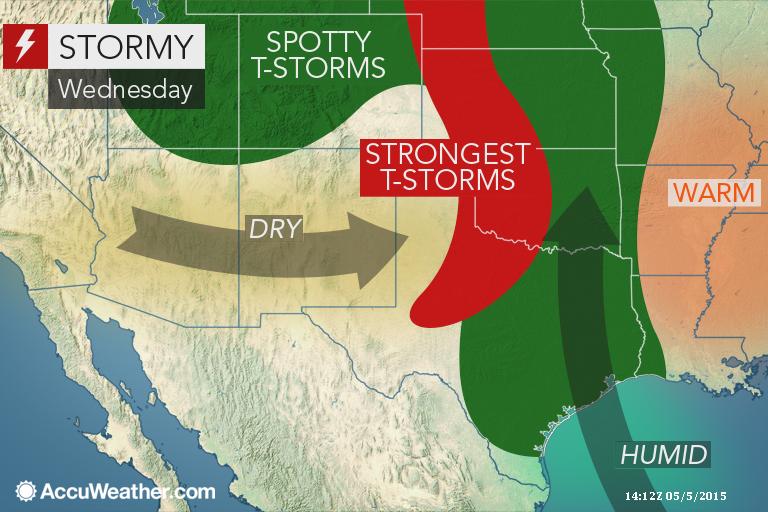
There will be some severe weather well to our west on Wednesday. Several days of severe weather is likely over the Central U.S. between now and the weekend. But, that is too our west. We will need to watch perhaps Monday/Monday night (see long range discussion).
AccuWeather graphic.
We will be warm over the coming days as a ridge of high pressure dominates our weather pattern. High pressure during the late spring and summer months usually means warm to hot temperatures. We won’t be hot, but we will be quite warm. I like to reserve the “hot” designation for temperatures of 90 degrees and above.
Wednesday morning low temperature forecast
Wednesday afternoon high temperature forecast
Thursday morning low temperature forecast
Thursday afternoon high temperature forecast
There will be very isolated shower and storm chances over the coming days. Most areas will continue to remain dry.
Rain and storm chances do increase on Friday through Monday. See the extended part of the forecast (further down in the blog) for those details.
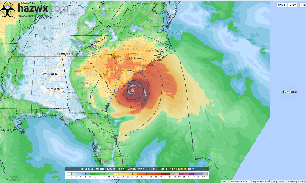
In the “hey that is odd” file! Will we have our first tropical storm of the season? It does appear possible. This is the weather map for Friday. Those are isobars (lines of equal pressure) surrounding the low off the southeast coast. The colors represent wind speed. Click for larger view. Image from hazwx.com
Some great photographs from the Wunderground web-site. I am a big fan of photography, as many of you know!
More photography images can be viewed on the Wunderground site
Meteor Shower on Tuesday night and Wednesday morning
Wednesday morning. Right now it appears viewing should be pretty good in our region. Click here for information on how to watch the meteor shower.

Don’t forget to support our sponsors!

No major changes to the ongoing forecast.

No major concerns.
Check out our sponsors! There are more on the right side bar of the page, as well. Be sure and let them know that you appreciate their sponsorship of the WeatherTalk daily weather bulletin.

Premier Portable Buildings proudly serving our region. For more information click the above ad or here
They can also be found on this Facebook page
G&C Multi-Services out of Paducah, Kentucky. G & C Multi-Services is a service provider in Western Kentucky that provides industrial and commercial equipment fabrication, machine troubleshooting, repair and maintenance, and installation. They can custom fabricate steel, stainless, and aluminum products per customer specifications.
Visit their web-site here. Or click the ad below! Facebook page.


Wortham Dental Care located in Paducah, Kentucky. The gentle dentist. Mercury free dentistry. They also do safe Mercury removal. You can find Wortham Dental Care on Facebook, as well

Trover’s Equipment and Lawn Care – Family owned and operated! They are a dealer for Snapper, Simplicity, Snapper Pro, Bad Boy Mowers, and Intimidator Utility Vehicles. They are a Stihl and Dolmar power products dealer. They also are a dealer for Briggs & Stratton, Kohler gas & diesel engines, and Kawasaki engines. They service and repair just about any brand. You can find them on Facebook, as well

Visit their web-site here. Or, you can also visit their Facebook page.

Endrizzi’s Storm Shelters – For more information click here. Endrizzi Contracting and Landscaping can be found on Facebook, as well – click here

Gary Eckelkamp’s web-site click the above banner or click here
.

Here are the current river stage forecasts. You can click your state and then the dot for your location. It will bring up the full forecast and hydrograph.
Click Here For River Stage Forecasts…

The wild card tells you where the uncertainties are in the forecast
Wild card in this forecast – I suppose the wild card should be the Friday-Monday precipitation chances. Will it or won’t it rain over the weekend at your location. My bet is that we have precipitation on radar. Questions remain on timing and coverage. If you have weekend plans then monitor updates and at least have a plan B in the back of your mind. This won’t be an all day rain event. But, at least some scattered showers and thunderstorms are probably going to occur in the region.

Can we expect severe thunderstorms over the next 24 to 48 hours? Remember that a severe thunderstorm is defined as a thunderstorm that produces 58 mph winds or higher, quarter size hail or larger, and/or a tornado.
Thunderstorm threat level is ZERO/ONE for Wednesday. A very isolated thunderstorm can’t completely be ruled out today through Thursday. Very very isolated if they were to occur. Just keep this in mind.
.
Wednesday Severe Weather Outlook – Severe Weather Is Not Anticipated
Thursday Severe Weather Outlook – Severe Weather Is Not Anticipated
Friday Severe Weather Outlook – Thunder possible
Saturday Severe Weather Outlook – Thunder possible
Sunday Severe Weather Outlook – Thunder possible
Monday Severe Weather Outlook – Monitor updates as a cold front approaches.


How much precipitation should we expect over the next few days?
Very isolated precipitation chances through Thursday. If a thunderstorm were to pop up then of course it could produce an isolated downpour. But, most areas will remain dry.
A more general precipitation event is possible by the weekend into Monday. Some locally heavy downpours will be possible (it’s that time of the year). I would not cancel any events or change any plans over the weekend. I would monitor updates and at least have a plan B in the back of your mind…just in case it does rain.

This section of the blog is speculative forecast information. Because it is past the range of what meteorologists can forecast accurately, it should be considered speculation. Anything past day 5 is considered a long range forecast.
Highlights:
1. Late spring-like pattern into the end of the week
2. A more general precipitation event is possible over the weekend into early next week.
3. Stronger storms on Monday along a cold front?
The main action in the long range forecast continues to center around Friday through Monday. A storm system will approach out of the southwest and west over the weekend. A cold front approaches the region on Sunday night and Monday.
Right now it still appears that precipitation chances will be on the increase over the weekend. The question remains, however, as to how widespread and the timing. I don’t have many new answers on that front, just yet.
I do believe we will see scattered showers and thunderstorms on radar Friday into Sunday. A more widespread precipitation event is likely along the cold front on Sunday night into Monday night. Again, timing is going to have to be worked out. The models are all over the place with placement of the front and the time table. No agreement.
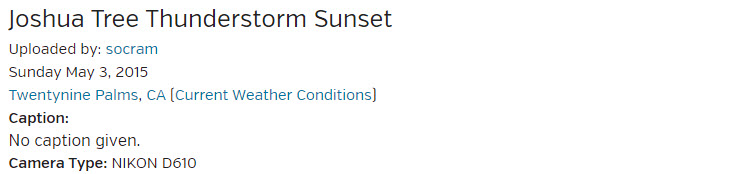
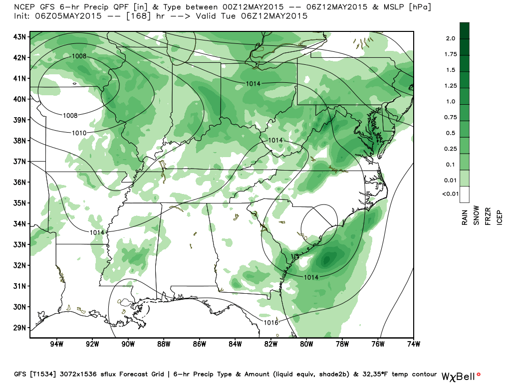
Here is the GFS model – green represents some precipitation.
This first image from weatherbell.com is for Friday evening. Perhaps some scattered showers and thunderstorms in the region on Friday/Friday night.
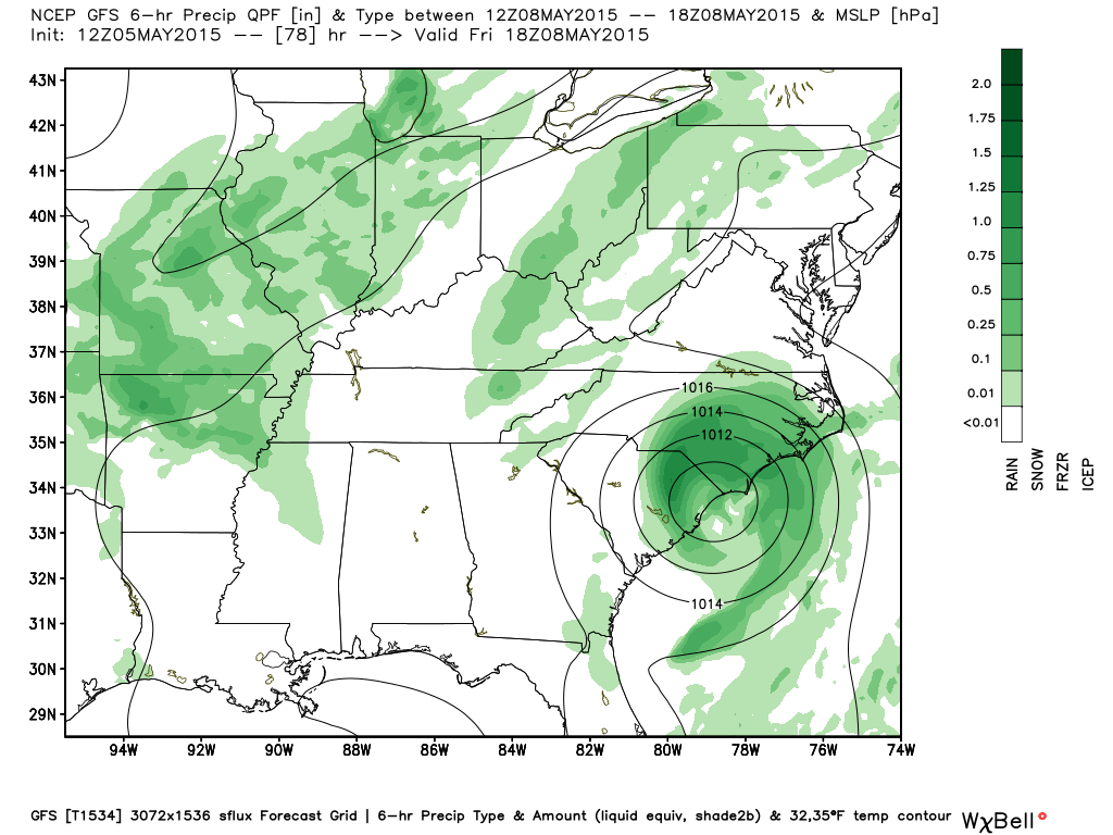
This next image is for Saturday afternoon. Again, some precipitation in the region on Saturday. Just how widespread the rain will be…still need to fine tune that part of the forecast.
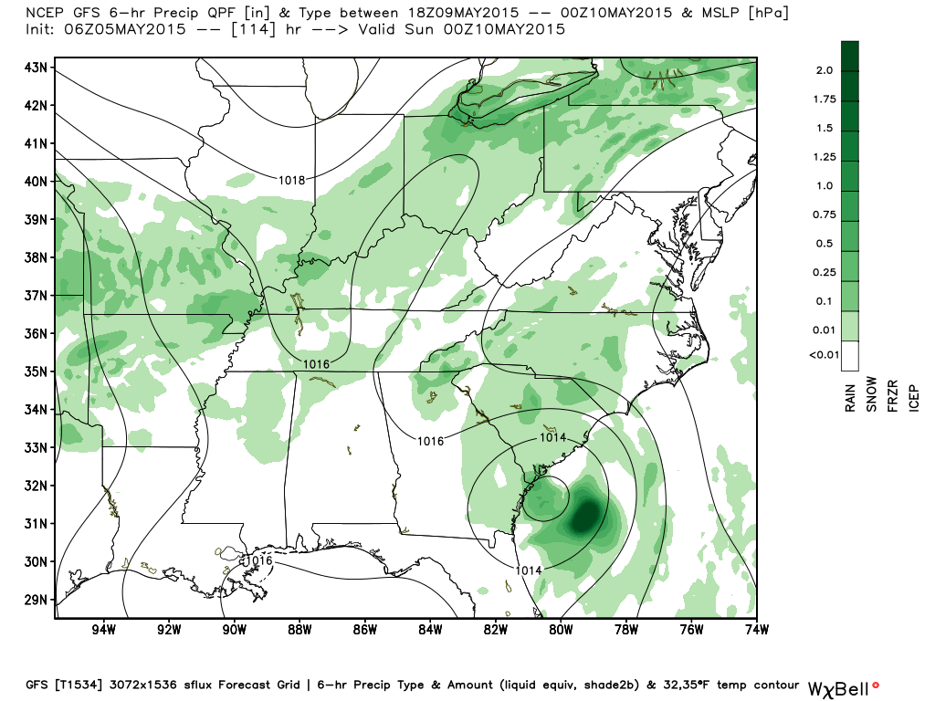
This next graphic is for Sunday evening. You can see the isobars tightening up over northern Missouri. That is the area of low pressure that will move into the Missouri and Ohio Valley on Monday and Tuesday. A cold front will accompany the area of low pressure.
If we were to have some heavier storms then perhaps it would be with this system as it pushes into and through our region.
This final image is for Monday night. You can see the area of low pressure to our north. We are obviously in the warm sector of the cyclone. That would mean some thunderstorm chances. Monitor updates. I can’t rule out severe weather, but the signals aren’t real strong either.
The threat for severe weather, at this time, appears minimal…over the weekend. Wind fields aloft are not impressive. One could make an argument for a better chance of strong storms along the cold front on Monday. But, even that is in question. Monitor updates if you have concerns.
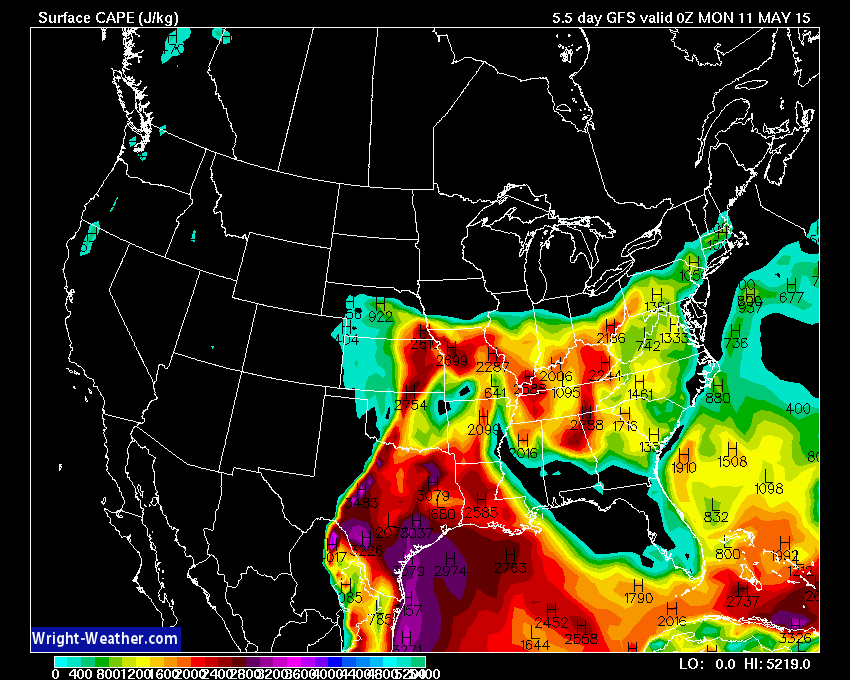
CAPE values (remember that CAPE is basically energy for storms) are going to be quite high on Sunday and Monday. Data indicates greater than 2000 CAPE at times. That would mean at least some strong storms.
Here are the CAPE maps from wright-weather.com
The bright colors are CAPE. You can see the scale at the bottom of the image. This is for Sunday evening.
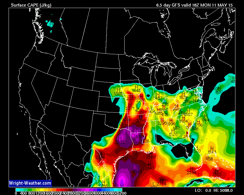
This image is for Monday afternoon. CAPE values. High CAPE readings over Arkansas and southward. Some spiking of CAPE in our region, as well.
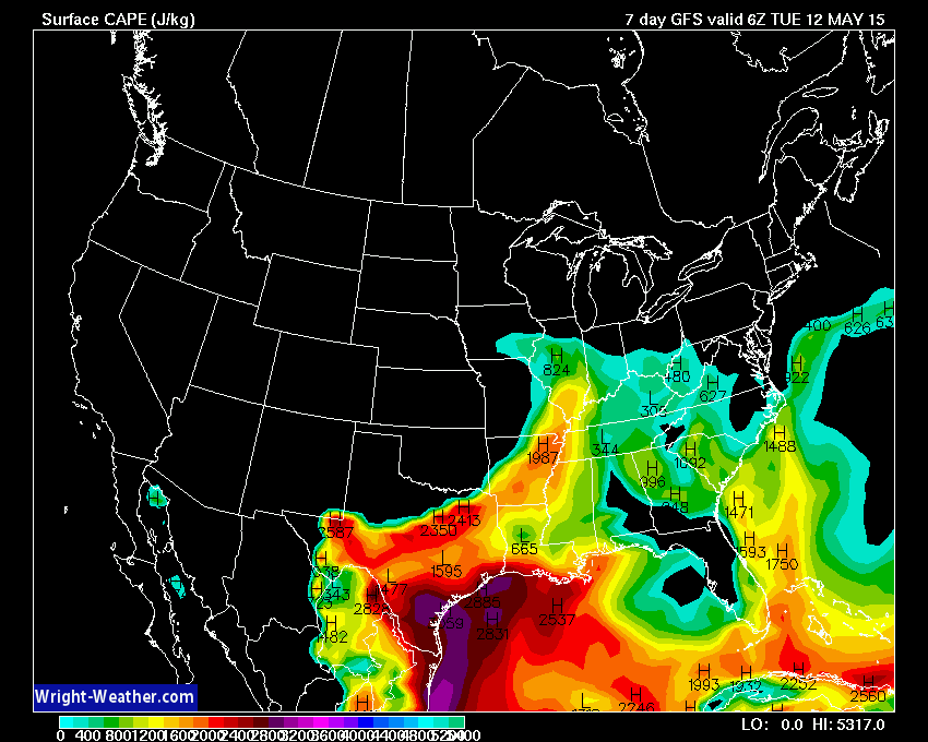
Then finally this is Monday evening. See the spike of colors into our area? That is ahead of the cold front.
The main concern for Friday through Monday, at this time, will be some locally heavy downpours and lightning.
If you have outdoor events this weekend then continue to monitor updates as we move along. I will start to pin down timing a bit more as we move into the late part of the week and we see where these upper level features are located.
Longer range (May into June)
Some early signals indicate June might bring below normal temperatures and above normal rainfall. Long way off and I am not a huge fan of long range outlooks. But, some charts are showing the above. We shall see.
In the meantime, what about the coming weeks? What are the charts showing?
Longer range outlook for temperatures below. Precipitation could also be above normal during the time frame mentioned below.
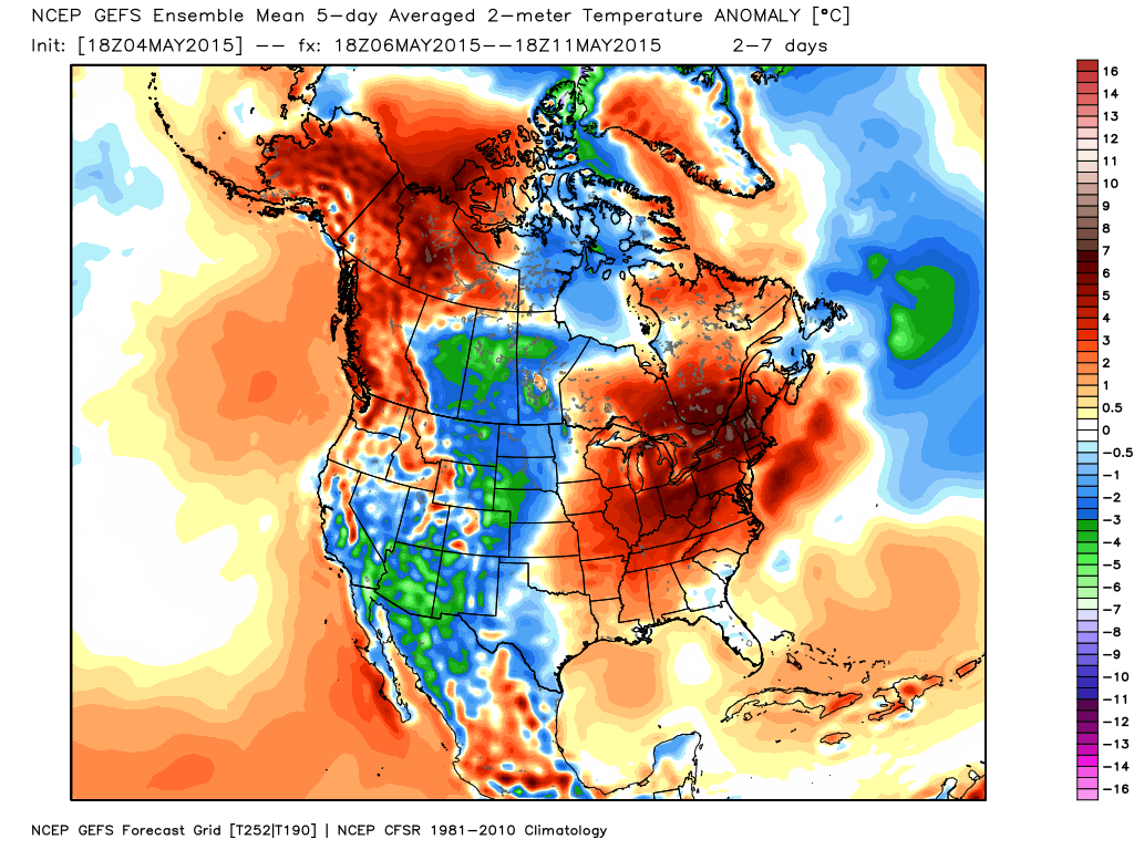
This map is the forecast anomalies for May 6th through May 11th. Will it be warmer than normal or cooler than normal? According to this forecast it will be warmer than normal. Lot of red on the map.
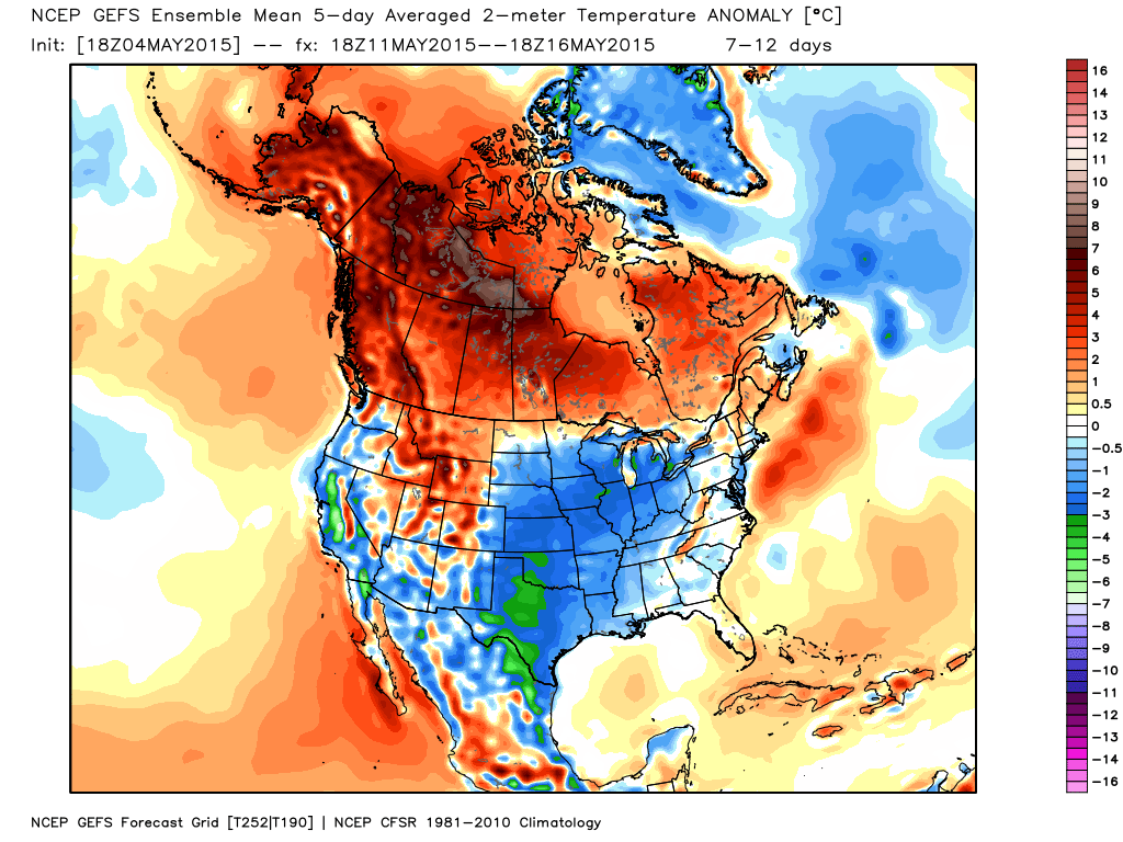
Now, this second map is for May 11th through the 16th. Cooler than normal? Might be according to these charts.
The EC ensembles, however, indicate that above normal temperatures will continue through much of May. We will see which one wins the temperature contest.
There is some debate in the meteorological community about how our summer will pan out. Some believe we may have a hot and dry summer.
The pattern for the last two years would indicate frequent northwest flow. That would mean cooler than normal temperatures. Is there reasons to believe this is going to change? We have been in that pattern for a very long time.
We will see how it goes.

We have regional radars and local city radars – if a radar does not seem to be updating then try another one. Occasional browsers need their cache cleared. You may also try restarting your browser. That usually fixes the problem. Occasionally we do have a radar go down. That is why I have duplicates. Thus, if one fails then try another one.
If you have any problems then please send me an email beaudodson@usawx.com
WEATHER RADAR PAGE – Click here —
We also have a new national interactive radar – you can view that radar by clicking here.
Local interactive city radars include St Louis, Mt Vernon, Evansville, Poplar Bluff, Cape Girardeau, Marion, Paducah, Hopkinsville, Memphis, Nashville, Dyersburg, and all of eastern Kentucky – these are interactive radars. Local city radars – click here
NOTE: Occasionally you will see ground clutter on the radar (these are false echoes). Normally they show up close to the radar sites – including Paducah.

Regional Radar – Click on radar to take you our full radar page.


Regional Radar

Live Lightning Data – zoom and pan: Click here
Live Lightning Data with sound (click the sound button on the left side of the page): Click here

I also set up a storm tracking page with additional links (use during active weather for quick reference)
Storm Tracking Tool Page
![]()
Current WARNINGS (a warning means take action now). Click on your county to drill down to the latest warning information. Keep in mind that there can be a 2-3 minute delay in the updated warning information.
I strongly encourage you to use a NOAA Weather Radio or warning cell phone app for the most up to date warning information. Nothing is faster than a NOAA weather radio.


Color shaded counties are under some type of watch, warning, advisory, or special weather statement. Click your county to view the latest information.

Missouri Warnings

Illinois Warnings

Kentucky Warnings

Please visit your local National Weather Service Office by clicking here. The National Weather Service Office, for our region, is located in Paducah, Kentucky. They have a lot of maps and information on their site. Local people…local forecasters who care about our region.

Here is the official 6-10 day and 8-14 day temperature and precipitation outlook. Check the date stamp at the top of each image (so you understand the time frame).
The forecast maps below are issued by the Weather Prediction Center (NOAA).


The latest 8-14 day temperature and precipitation outlook. Note the dates are at the top of the image. These maps DO NOT tell you how high or low temperatures or precipitation will be. They simply give you the probability as to whether temperatures or precipitation will be above or below normal.


Who do you trust for your weather information and who holds them accountable?
I have studied weather in our region since the late 1970’s. I have 37 years of experience in observing our regions weather patterns. My degree is in Broadcast Meteorology from Mississippi State University and an Associate of Science (AS). I am currently working on my Bachelor’s Degree in Geoscience. Just need to finish two Spanish classes!
I am a member of the American Meteorological Society. I am a NOAA Weather-Ready Nation Ambassador. And, I am the Meteorologist for McCracken County Emergency Management.
I own and operate the Southern Illinois Weather Observatory.
There is a lot of noise on the internet. A lot of weather maps are posted without explanation. Over time you should learn who to trust for your weather information.
My forecast philosophy is simple and straight forward.
- Communicate in simple terms
- To be as accurate as possible within a reasonable time frame before an event
- Interact with you on Twitter, Facebook, and the blog
- Minimize the “hype” that you might see on television or through other weather sources
- Push you towards utilizing wall-to-wall LOCAL TV coverage during severe weather events
I am a recipient of the Mark Trail Award, WPSD Six Who Make A Difference Award, Kentucky Colonel, and the Caesar J. Fiamma” Award from the American Red Cross. In 2009 I was presented with the Kentucky Office of Highway Safety Award. I was recognized by the Kentucky House of Representatives for my service to the State of Kentucky leading up to several winter storms and severe weather outbreaks.
If you click on the image below you can read the Kentucky House of Representatives Resolution.

I am also President of the Shadow Angel Foundation which serves portions of western Kentucky and southern Illinois.
Many of my graphics are from www.weatherbell.com – a great resource for weather data, model data, and more


This blog was inspired by ABC 33/40’s Alabama Weather Blog – view their blog
Current tower cam view from the Weather Observatory- Click here for all cameras.

Southern Illinois Weather Observatory

The Weather Observatory

Southern Illinois Weather Observatory
WSIL TV 3 has a number of tower cameras. Click here for their tower camera page & Illinois Road Conditions

Marion, Illinois
WPSD TV 6 has a number of tower cameras. Click here for their tower camera page & Kentucky Road Conditions & Kentucky Highway and Interstate Cameras

Downtown Paducah, Kentucky
Benton, Kentucky Tower Camera – Click here for full view

Benton, Kentucky

I24 Paducah, Kentucky

I24 Mile Point 9 – Paducah, KY

I24 – Mile Point 3 Paducah, Kentucky

You can sign up for my AWARE email by clicking here I typically send out AWARE emails before severe weather, winter storms, or other active weather situations. I do not email watches or warnings. The emails are a basic “heads up” concerning incoming weather conditions.