WeatherTalk monthly operating costs can top $2000.00. Your $3 subscription helps pay for those costs. I work for you.
For $3 a month you can receive the following. You may choose to receive these via your WeatherTalk app or regular text messaging.
- Severe weather app/text alerts from my keyboard to your app/cell phone. These are hand typed by Beau. During tornado outbreaks, you will receive numerous app/text messages telling you exactly where the tornado is located.
- Daily forecast app/texts from my computer to your app/cell phone.
- Social media links sent directly to your app/cell phone. When I update the blog, videos, or Facebook you will receive the link.
- AWARE emails. These emails keep you well ahead of the storm. They give you several days of lead time before significant weather events.
- Direct access to Beau via text and email. Your very own personal meteorologist. I work for you!
- Missouri and Ohio Valley centered video updates
- Long-range weather videos
- Week one, two, three and four temperature and precipitation outlooks.
- Monthly outlooks.
- Your subscription also will help support several local charities.
Haven’t you subscribed? Subscribe at www.beaudodsonweather.com

Example of a recent severe weather alert. I issued this well before the official tornado warning. You would have had plenty of time for you and your family to seek shelter.


Your $3 per month also helps support these local charity projects.

I encourage subscribers to use the app vs regular text messaging. We have found text messaging to be delayed during severe weather. The app typically will receive the messages instantly. I recommend people have three to four methods of receiving their severe weather information.
Remember, my app and text alerts are hand typed and not computer generated. You are being given personal attention during significant weather events.

WWW.WEATHERTALK.COM subscribers, here is my day to day schedule for your weather products.


Wednesday Forecast Details
Forecast: Mostly to partly sunny. Warm. Only a 10% chance of a thunderstorm.
Temperatures: MO ~ 84 to 88 IL ~ 84 to 88 KY ~ 84 to 88 TN ~ 84 to 88
What is the chance of precipitation? MO ~ 10% IL ~ 10% KY ~ 10% TN ~ 10%
Coverage of precipitation: None to isolated
Winds: Light winds
What impacts are anticipated from the weather? Most likely none. Isolated wet roadways. Lightning.
My confidence in the forecast verifying: High
Is severe weather expected? No
The NWS defines severe weather as 58 mph wind or great, 1″ hail or larger, and/or tornadoes
Should I cancel my outdoor plans? No
UV Index: 9 – Very high
Sunrise: 5:40 AM
Wednesday Night Forecast Details:
Forecast: Mostly sunny. Patchy fog.
Temperatures: MO ~ 62 to 65 IL ~ 58 to 64 KY ~ 63 to 66 TN ~ 63 to 66
What is the chance of precipitation? MO ~ 10% IL ~ 10% KY ~ 10% TN ~ 10%
Coverage of precipitation: None
Winds: East and northeast at 4 to 8 mph
What impacts are anticipated from the weather? Most likely none.
My confidence in the forecast verifying: High
Is severe weather expected? No
The NWS defines severe weather as 58 mph wind or great, 1″ hail or larger, and/or tornadoes
Should I cancel my outdoor plans? No
Sunset: 8:03 PM
Moonrise: 2:14 PM Waxing Gibbous
Moonset: 2:32 AM
May 24, 2018
Thursday Forecast Details
Forecast: Mostly sunny. Warm.
Temperatures: MO ~ 84 to 88 IL ~ 84 to 88 KY ~ 84 to 88 TN ~ 84 to 88
What is the chance of precipitation? MO ~ 5% IL ~ 5% KY ~ 5% TN ~ 5%
Coverage of precipitation: None
Winds: East and northeast 4 to 8 mph
What impacts are anticipated from the weather? Most likely none.
My confidence in the forecast verifying: No
The NWS defines severe weather as 58 mph wind or great, 1″ hail or larger, and/or tornadoes
Should I cancel my outdoor plans? No
UV Index: 9 – Very high
Sunrise: 5:40 AM
Thursday Night Forecast Details:
Forecast: Mostly clear. A chance of fog. Only a 10% chance of a thunderstorm. Again, typical summer pattern. Most areas will remain dry.
Temperatures: MO ~ 62 to 66 IL ~ 58 to 64 KY ~ 62 to 66 TN ~ 62 to 66
What is the chance of precipitation? MO ~ 10% IL ~ 10% KY ~ 10% TN ~ 10%
Coverage of precipitation: None
Winds: Southeast and east at 4 to 8 mph
What impacts are anticipated from the weather? Most likely none.
My confidence in the forecast verifying: High
Is severe weather expected? No
The NWS defines severe weather as 58 mph wind or great, 1″ hail or larger, and/or tornadoes
Should I cancel my outdoor plans? No
Sunset: 8:04 PM
Moonrise: 3:17 PM Waxing Gibbous
Moonset: 3:06 AM
May 25, 2018
Friday Forecast Details
Forecast: Mostly sunny. Warm. I can’t rule out an isolated thunderstorm. Again, typical summer pattern. Most areas will remain dry
Temperatures: MO ~ 85 to 88 IL ~ 85 to 88 KY ~ 85 to 88 TN ~ 85 to 88
What is the chance of precipitation? MO ~ 20% IL ~ 10% KY ~ 10% TN ~ 10%
Coverage of precipitation: None to isolated
Winds: Light winds
What impacts are anticipated from the weather? None. Isolated wet roads and lightning.
My confidence in the forecast verifying: Medium
Is severe weather expected? Unlikely
The NWS defines severe weather as 58 mph wind or great, 1″ hail or larger, and/or tornadoes
Should I cancel my outdoor plans? No
UV Index: 9 – Very high
Sunrise: 5:39 AM
Friday Night Forecast Details:
Forecast: Partly cloudy. Widely scattered storms possible. Many areas will again remain dry.
Temperatures: MO ~ 65 to 68 IL ~ 65 to 68 KY ~ 65 to 70 TN ~ 65 to 70
What is the chance of precipitation? MO ~ 20% IL ~ 20% KY ~ 20% TN ~ 20%
Coverage of precipitation: None to isolated
Winds: South at 4 to 8 mph
What impacts are anticipated from the weather? None. Isolated wet roadways. Lightning.
My confidence in the forecast verifying: High
Is severe weather expected? Unlikely
The NWS defines severe weather as 58 mph wind or great, 1″ hail or larger, and/or tornadoes
Should I cancel my outdoor plans? No
Sunset: 4:19 PM
Moonrise: 1:09 PM Waxing Gibbous
Moonset: 3:38 AM
May 26, 2018
Saturday Forecast Details
Forecast: Partly cloudy. A chance of scattered showers and thunderstorms.
Temperatures: MO ~ 85 to 88 IL ~ 85 to 88 KY ~ 85 to 88 TN ~ 85 to 88
What is the chance of precipitation? MO ~ 30% IL ~ 30% KY ~ 30% TN ~ 30%
Coverage of precipitation: Scattered
Winds: South 4 to 8 mph
What impacts are anticipated from the weather? Wet roads and lightning.
My confidence in the forecast verifying: Medium
Is severe weather expected? Unlikely, but isolated reports of hail or strong winds are always possible with summer type thunderstorms.
The NWS defines severe weather as 58 mph wind or great, 1″ hail or larger, and/or tornadoes
Should I cancel my outdoor plans? No, but monitor radars.
UV Index: 8 – High
Sunrise: 5:38 AM
Saturday Night Forecast Details:
Forecast: Partly cloudy. Scattered showers and thunderstorms possible.
Temperatures: MO ~ 66 to 68 IL ~ 66 to 68 KY ~ 66 to 70 TN ~ 66 to 70
What is the chance of precipitation? MO ~ 30% IL ~ 30% KY ~ 30% TN ~ 30%
Coverage of precipitation: Scattered
Winds: South at 5 to 10 mph.
What impacts are anticipated from the weather? Scattered wet roadways. Lightning.
My confidence in the forecast verifying: Medium
Is severe weather expected? Unlikely
The NWS defines severe weather as 58 mph wind or great, 1″ hail or larger, and/or tornadoes
Should I cancel my outdoor plans? No, but check radars
Sunset: 8:05 PM
Moonrise: 5:19 PM Waxing Gibbous
Moonset: 4:10 AM
May 27, 2018
Sunday Forecast Details
Forecast: A mix of sun and clouds. A chance of showers and thunderstorms.
Temperatures: MO ~ 83 to 86 IL ~ 83 to 86 KY ~ 83 to 86 TN ~ 84 to 88
What is the chance of precipitation? MO ~ 40% IL ~ 40% KY ~ 40% TN ~ 40%
Coverage of precipitation: Scattered
Winds: South 4 to 8 mph
What impacts are anticipated from the weather? Wet roads and lightning.
My confidence in the forecast verifying: Medium
Is severe weather expected? Unlikely, but isolated reports of hail or strong winds are always possible with summer type thunderstorms.
The NWS defines severe weather as 58 mph wind or great, 1″ hail or larger, and/or tornadoes
Should I cancel my outdoor plans? No, but monitor radars.
UV Index: 8 – High
Sunrise: 5:38 AM
Sunday Night Forecast Details:
Forecast: Partly cloudy. Scattered showers and thunderstorms possible.
Temperatures: MO ~ 66 to 68 IL ~ 66 to 68 KY ~ 66 to 70 TN ~ 66 to 70
What is the chance of precipitation? MO ~ 40% IL ~ 40% KY ~ 40% TN ~ 40%
Coverage of precipitation: Scattered
Winds: East and southeast at 5 to 10 mph.
What impacts are anticipated from the weather? Scattered wet roadways. Lightning.
My confidence in the forecast verifying: Medium
Is severe weather expected? Unlikely
The NWS defines severe weather as 58 mph wind or great, 1″ hail or larger, and/or tornadoes
Should I cancel my outdoor plans? No, but check radars
Sunset: 8:06 PM
Moonrise: 6:19 PM Waxing Gibbous
Moonset: 4:42AM
May 28, 2018
Monday Forecast Details
Forecast: Mostly cloudy. A chance of showers and thunderstorms.
Temperatures: MO ~ 83 to 86 IL ~ 83 to 86 KY ~ 83 to 86 TN ~ 84 to 88
What is the chance of precipitation? MO ~ 40% IL ~ 40% KY ~ 40% TN ~ 40%
Coverage of precipitation: Scattered
Winds: South 4 to 8 mph
What impacts are anticipated from the weather? Wet roads and lightning.
My confidence in the forecast verifying: Medium
Is severe weather expected? Unlikely, but isolated reports of hail or strong winds are always possible with summer type thunderstorms.
The NWS defines severe weather as 58 mph wind or great, 1″ hail or larger, and/or tornadoes
Should I cancel my outdoor plans? No, but monitor radars.
UV Index: 7 – High
Sunrise: 5:37 AM
Monday Night Forecast Details:
Forecast: Partly cloudy. Isolated showers and thunderstorms.
Temperatures: MO ~ 64 to 68 IL ~ 64 to 68 KY ~ 64 to 68 TN ~ 64 to 68
What is the chance of precipitation? MO ~ 30% IL ~ 30% KY ~ 30% TN ~ 30%
Coverage of precipitation: Isolated to widely scattered
Winds: Northeast and east at 4 to 8 mph
What impacts are anticipated from the weather? Wet roadways. Lightning.
My confidence in the forecast verifying: Medium
Is severe weather expected? Unlikely
The NWS defines severe weather as 58 mph wind or great, 1″ hail or larger, and/or tornadoes
Should I cancel my outdoor plans? No, but check radars
Sunset: 8:07 PM
Moonrise: 7:18 PM Waxing Gibbous
Moonset: 5:16 AM
May 29, 2018
Tuesday Forecast Details
Forecast: Mostly cloudy. A chance of showers and thunderstorms.
Temperatures: MO ~ 83 to 86 IL ~ 83 to 86 KY ~ 83 to 86 TN ~ 84 to 88
What is the chance of precipitation? MO ~ 40% IL ~ 40% KY ~ 40% TN ~ 40%
Coverage of precipitation: Scattered
Winds: Variable at 5 to 10 mph
What impacts are anticipated from the weather? Wet roads and lightning.
My confidence in the forecast verifying: Medium
Is severe weather expected? Monitor
The NWS defines severe weather as 58 mph wind or great, 1″ hail or larger, and/or tornadoes
Should I cancel my outdoor plans? No, but monitor radars.
UV Index: 6 – Medium
Sunrise: 5:37 AM
Tuesday Night Forecast Details:
Forecast: Mostly cloudy. Scattered showers and thunderstorms.
Temperatures: MO ~ 64 to 68 IL ~ 64 to 68 KY ~ 64 to 68 TN ~ 64 to 68
What is the chance of precipitation? MO ~ 30% IL ~ 30% KY ~ 30% TN ~ 30%
Coverage of precipitation: Scattered
Winds: Northeast and east at 4 to 8 mph
What impacts are anticipated from the weather? Wet roadways. Lightning.
My confidence in the forecast verifying: Medium
Is severe weather expected? Monitor
The NWS defines severe weather as 58 mph wind or great, 1″ hail or larger, and/or tornadoes
Should I cancel my outdoor plans? No, but check radars
Sunset: 8:07 PM
Moonrise: 8:16 PM Full Moon
Moonset: 5:54 AM
RAIN TOTALS
It is important to remember, late spring and summer thunderstorms can drop a lot of rain in a short amount of time. Rain rates can occasionally exceed 1.5 to 2″ per hour. This can cause brief periods of flash flooding or ponding of water.
It is next to impossible to forecast which county will receive more rain than a neighboring county. Typical, for our region. Your neighbor can pick up a heavy thunderstorm and you end up with just a few drops.

Interactive Radars:
Interactive live weather radar page. Choose the city nearest your location. If one of the city radars won’t load then try a nearby one. Click here.

Questions? Broken links? Other?
You may email me at beaudodson@usawx.com

The National Weather Service defines a severe thunderstorm as one that produces quarter size hail or larger, 58 mph winds or greater, and/or a tornado.
Wednesday through Saturday night: Mostly isolated storm chances the rest of the week. For those who end up underneath one of these thunderstorms you can expect heavy rain, gusty winds, small hail, and lightning. Isolated reports of flash flooding are possible. An isolated report of high winds would be possible. The threat of severe weather is rather low.
Sunday through Tuesday: Locally heavy thunderstorms are again possible. We will need to monitor the severe weather risk.
![]()
Interactive live weather radar page. Choose the city nearest your location. If one of the cities does not work then try a nearby one. Click here.
National map of weather watches and warnings. Click here.
Storm Prediction Center. Click here.
Weather Prediction Center. Click here.

Live lightning data: Click here.

Interactive GOES R satellite. Track clouds. Click here.

Here are the latest local river stage forecast numbers Click Here.
Here are the latest lake stage forecast numbers for Kentucky Lake and Lake Barkley Click Here.

The spring and preliminary summer outlooks have been posted for subscribers. Scroll down to see the outlook.
Not a subscriber? Learn more at this link.

Weather Headlines
- Stagnant weather pattern.
- Warm temperatures. Cool nights.
- Somewhat lower dew points over the coming days with northeast winds.
- Warm and muggy weather the rest of the week.
- An increase in thunderstorm activity again possible as we move into the weekend and next week.
- Locally heavy rain where storms occur.
- Many areas will remain dry through at least Friday night.
Well, nature is making this forecast rather easy and straight-forward.
We will be under the influence of ridging over the coming days. This will help keep a lid on shower and thunderstorm activity. If storms were to form, then they would be isolated through Friday night.
Highs each day will reach into the 80’s. Overnight lows will dip into the 58 to 66 degree range. Coolest over northern portions of southern Illinois and warmest towards Poplar Bluff and northwest Tennessee.
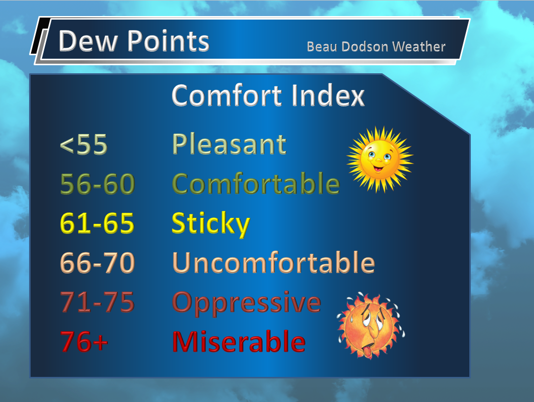
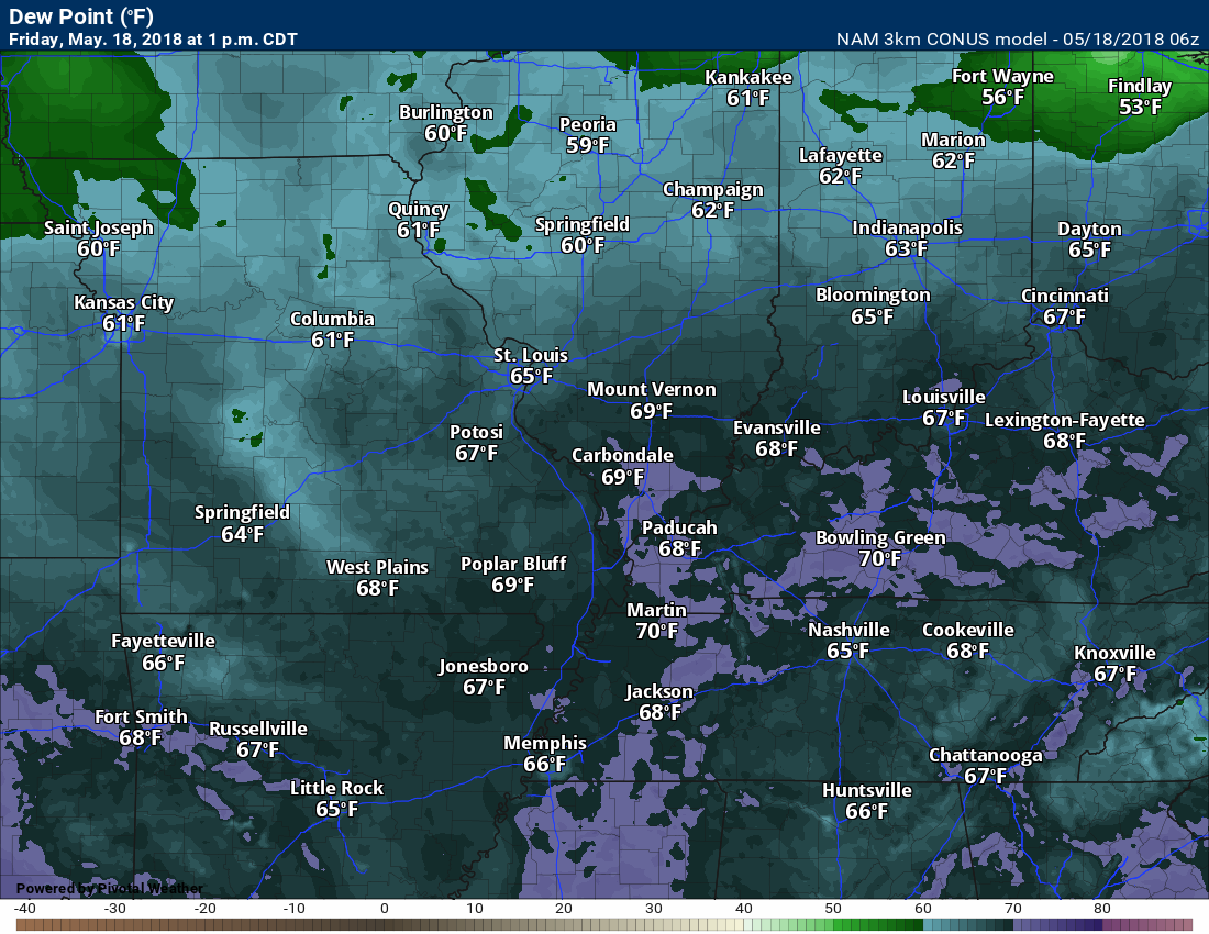
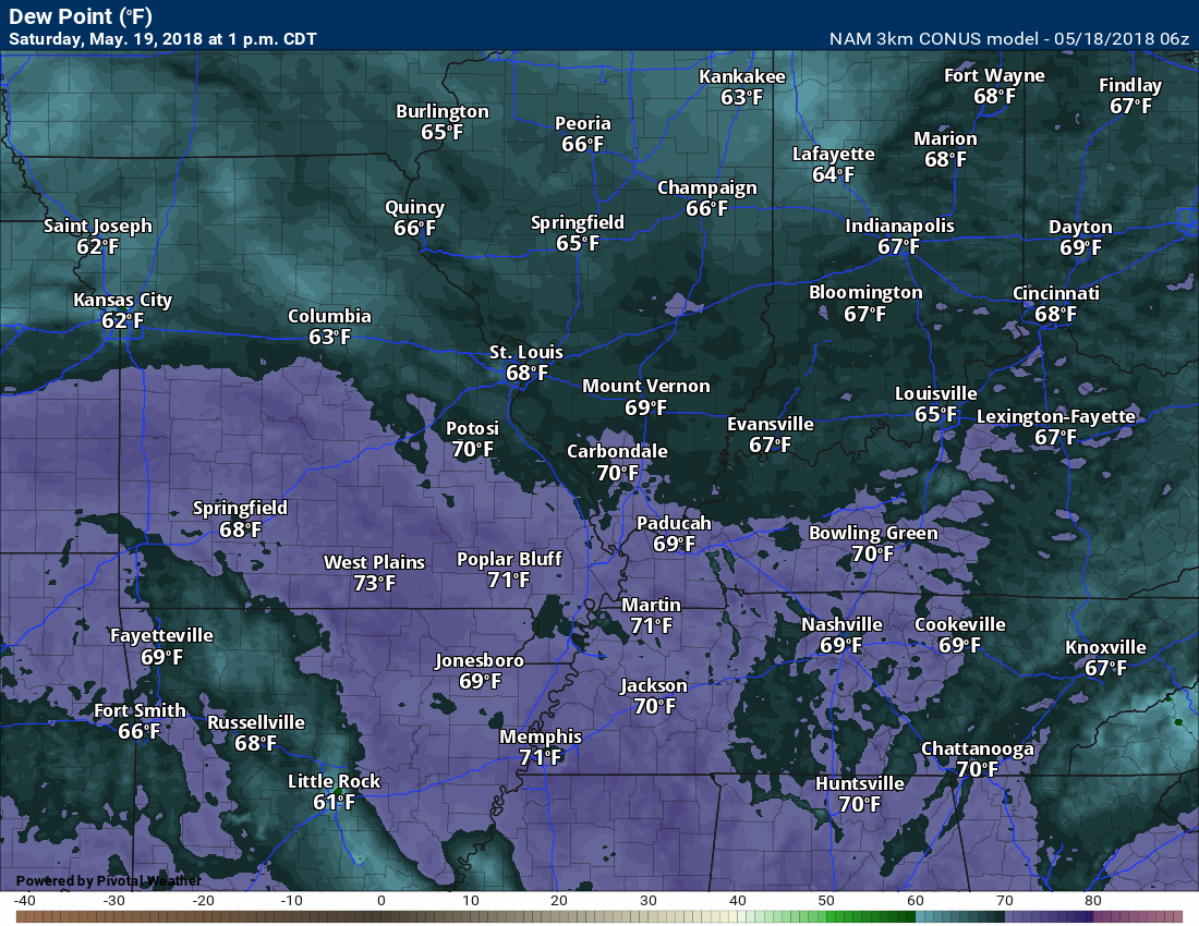
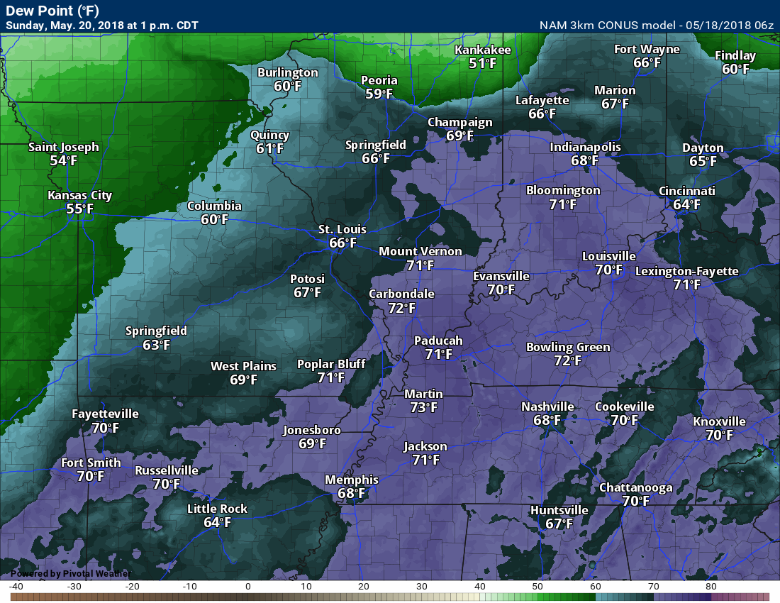
Dew points will remain high, but not as high as recent days.
Here is the Wednesday, Thursday, and Friday dew point forecast map. Notice the number rise Friday. Friday will feel more uncomfortable than today.
Thursday
Thursday
Friday
Rain chances today through Friday night will hover in the 5% to 10% range. Perhaps 20% by Friday night.
Weekend rain chances will increase a bit as the ridge of high pressure breaks down.
A tropical system in the Gulf of Mexico will need to be monitored. This system may spread clouds and moisture back into our region by the weekend and next week. This slow moving system could meander around the southern United States for several days.
The exact track of the system will be key to our local weather.
Model guidance takes it anywhere from Florida to Louisiana. Still a bit early to know for sure.
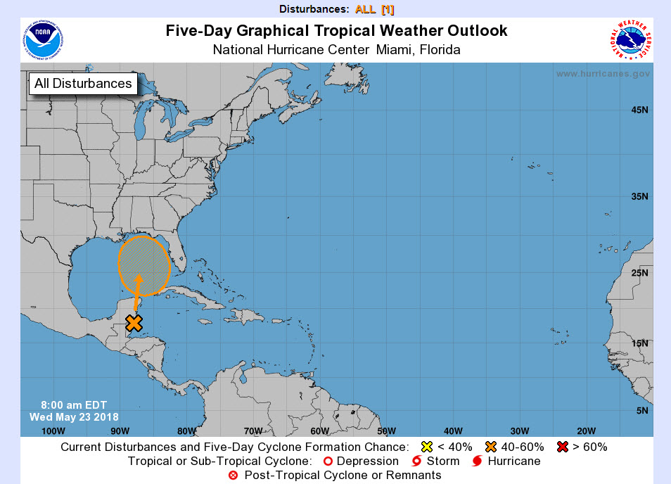
The National Hurricane Center gives this system a 60% of becoming a tropical depression or tropical storm.
The main concern will be heavy rain.
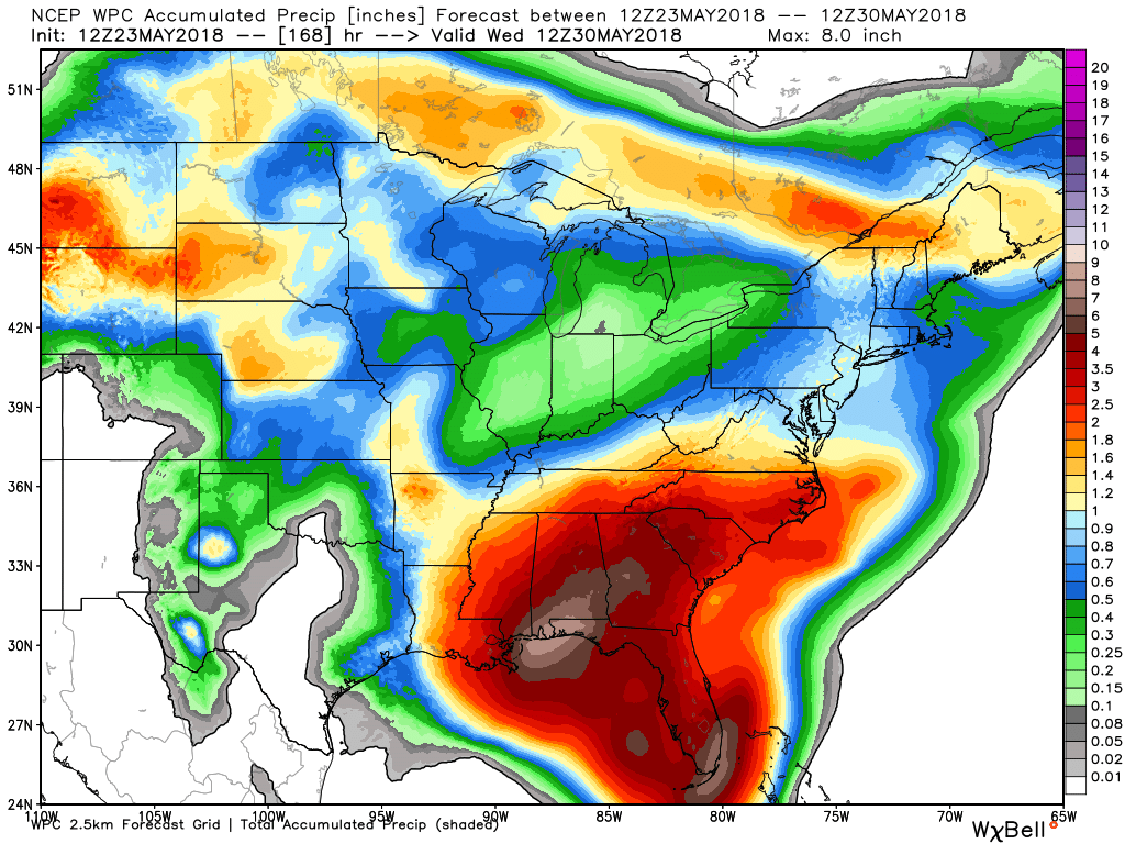
Here is the 7 day rainfall totals. Notice all the heavy rain to our south and southeast. That is because of the tropical system.
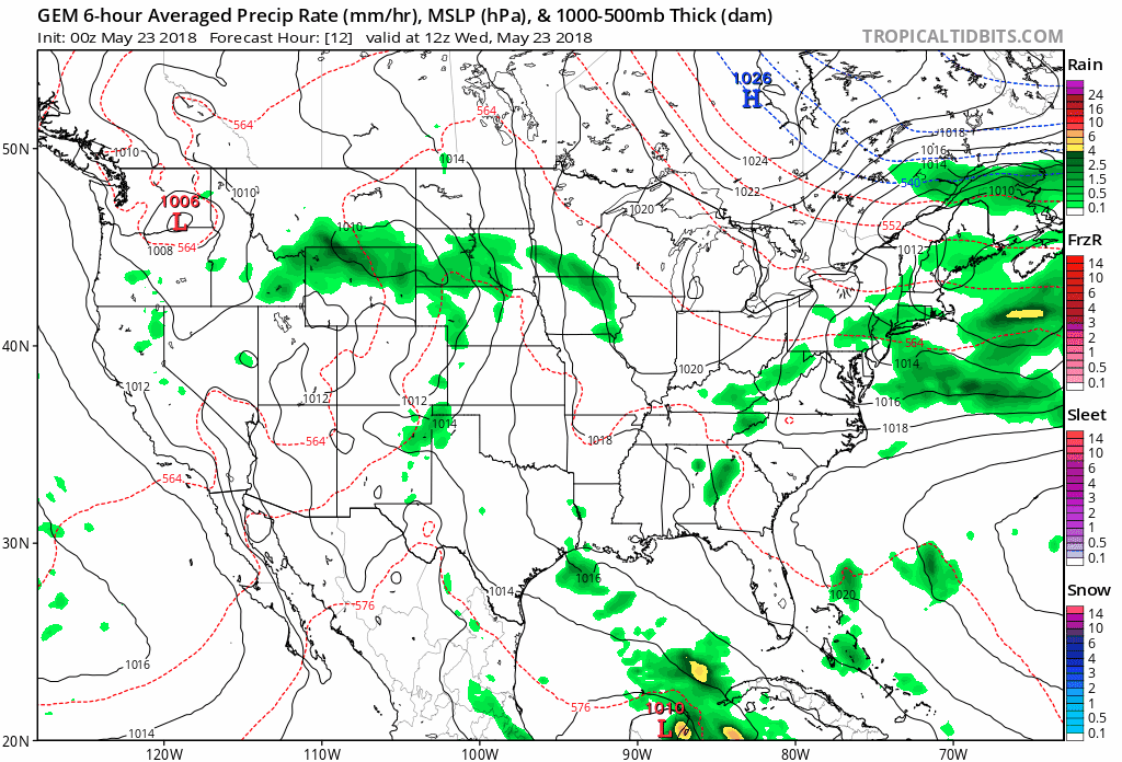
Here is the rainfall graphic through 198 hours. See the spin coming out of the Gulf of Mexico. That is the tropical system. Where it tracks is a big question mark.
This model tracks it into the Gulf of Mexico and brings it ashore.
Again, rain is the concern.
![]()

A new weather podcast is now available! Weather Geeks (which you might remember is on The Weather Channel each Sunday)
To learn more visit their website. Click here.
![]()

WeatherBrains Episode 643
Tonight’s Guest WeatherBrain is a Research Meteorologist at National Severe Storms Laboratory and a visiting Professor of Atmospheric Science at Desert Research Institute and the University of Nevada-Reno. He is the author of the recent AMS Book: Verner Soumi: The Life and Work of the Founder of Satellite Meteorology. He joins us tonight from his daughter’s home in Sacramento. Please welcome Dr. John Lewis to WeatherBrains.
Throughout his career, Dr. Lewis has conducted research that has combined weather analysis with numerical weather prediction. His professional experience has been divided between work in government labs including operational prediction centers and academia. In the past decade, he has led a national research project focused on the weather over the Gulf of Mexico, Project GUFMEX, explored the use of adjoint methods to study model sensitivity, and contributed to the history of science. In 1998, the Environmental Research Laboratories of NOAA assigned Dr. Lewis to Desert Research Institute on a long-term duty assignment. This assignment was made in connection with a 5-year plan to improve weather forecasting in the Western United States. Central to this effort is the use of adjoint models to clarify the relative importance of the various meteorological fields used to initialize deterministic prediction models.
Other discussions in this weekly podcast include topics like:
- Extremes: 102 at Rio Grande Village, TX, and 23 at Stanley, ID, Crested Butte, CO, & Gothic, CO
- Non-tropical low off the west coast of Florida
- Severe weather Tuesday over Mid-Atlantic states
- Serious drought from AZ to West TX
- Fairly warm across the continental US
- Astronomy Outlook with Tony Rice
- and more!
Previous episodes can be viewed by clicking here.

We offer interactive local city live radars and regional radars. If a radar does not update then try another one. If a radar does not appear to be refreshing then hit Ctrl F5. You may also try restarting your browser.
The local city view radars also have clickable warnings.
During the winter months, you can track snow and ice by clicking the winterize button on the local city view interactive radars.
You may email me at beaudodson@usawx.com
Find me on Facebook!

Find me on Twitter!

Did you know that a portion of your monthly subscription helps support local charity projects?
You can learn more about those projects by visiting the Shadow Angel Foundation website and the Beau Dodson News website.

I encourae subscribers to use the app vs regular text messaging. We have found text messaging to be delayed during severe weather. The app typically will receive the messages instantly. I recommend people have three to four methods of receiving their severe weather information.
Remember, my app and text alerts are hand typed and not computer generated. You are being given personal attention during significant weather events.
