.

Radar Link: Interactive local city-view radars & regional radars.
You will find clickable warning and advisory buttons on the local city-view radars.
If the radar is not updating then try another one. If a radar does not appear to be refreshing then hit Ctrl F5. You may also try restarting your browser.
Not working? Email me at beaudodson@usawx.com
Storm Prediction Center. Click here.
Weather Prediction Center. Click here.
Previous updates below it.
.
FACEBOOK Q&A LINK
https://wtalk.co/8FUTJ7QW
Beau’s email beaudodson@usawx.com
.
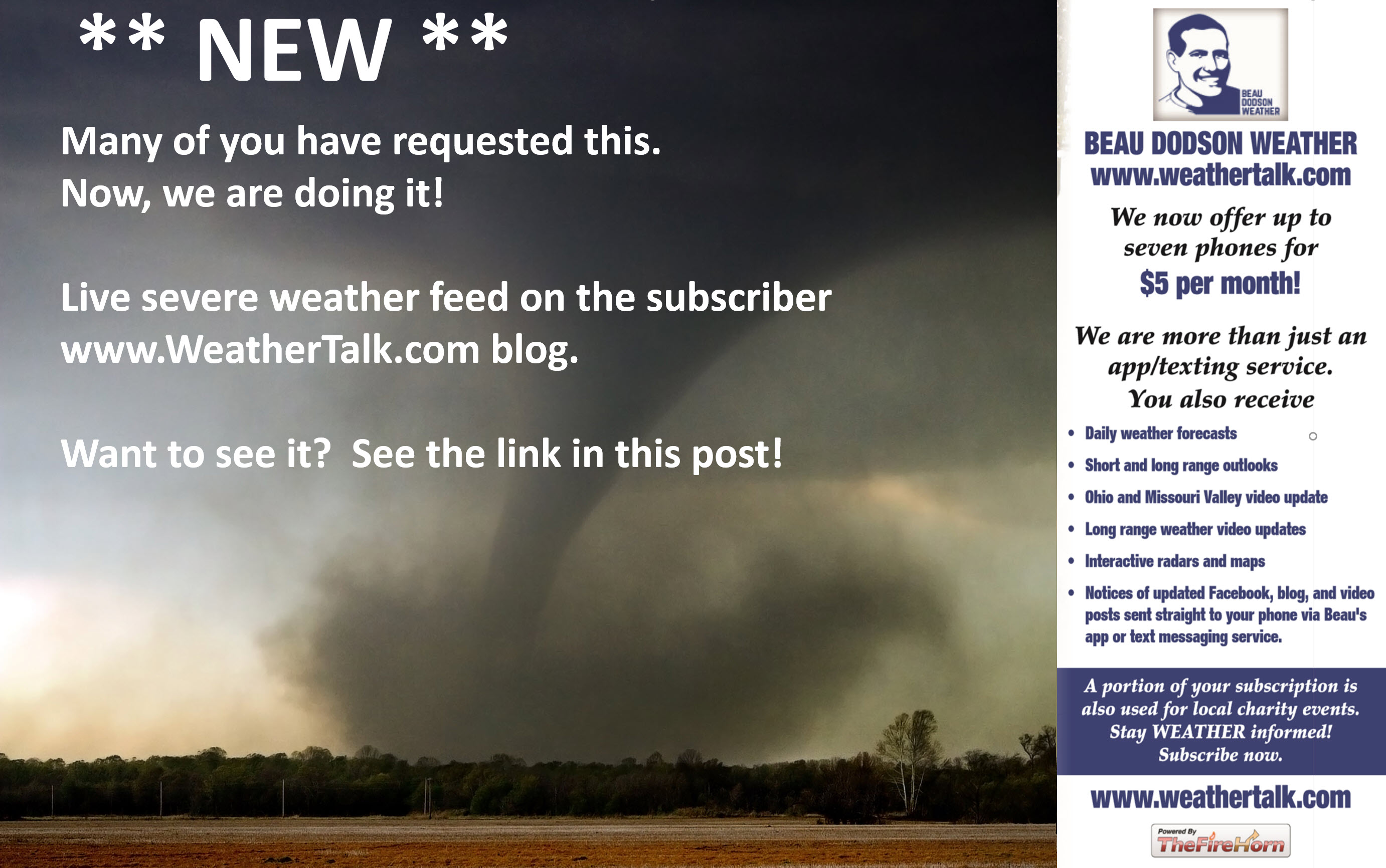
Subscribe to the LIVE severe weather feeds at www.weathertalk.com
.
12 AM
End of this event
11:30 PM
The line of storms continues to rapidly weaken as it moves east.
.
11:14 PM
Storms in far western KY are behind the gust front. Typically, that means they are not severe. Locally heavy rain and lightning.
The severe weather concerns have come to an end. I do not expect any additional warnings.
CAPE values (energy) are dropping. The main band of storms will continue to slowly move east and stall.
Rain will continue into tomorrow morning across the Bootheel, western Kentucky, and mainly southeast Illinois.
.

.
10:42 PM
Jefferson, Franklin, Williamson, and Johnson. The rotation has currently weakened but radars show strong winds with some of these storms. Hamilton, Saline, and Pope will eventually receive these storms. Unless a tornado warning is issued I will leave this as the last message.
.
10:34 PM
Local Storm Report by NWS PAH: 3 SE Anna [Union Co, IL] trained spotter reports TSTM WND GST of E60 MPH at 10:19 PM CDT — 2.5 miles SE of Anna at the intersection of HWY 51 and 630 N.
.
10:21 PM
PAH NWS issues Severe Thunderstorm Warning [tornado: POSSIBLE, wind: 60 MPH, hail: 0.88 IN] for Franklin, Williamson [IL] till 11:00 PM CDT
.
10:21 PM
Local Storm Report by NWS PAH: Carterville [Williamson Co, IL] trained spotter reports TSTM WND GST of E55 MPH at 10:15 PM CDT — estimated 55 mph winds and penny sized hail.
.
10:20 PM
Western Pulaski County. SE Union County. Radar shows high winds on the county border with NE Alexander County. The storm is moving NE at 50 mph.
.
10:17 PM
Rotation approaching Carterville, IL. Be alert. Small tight area of rotation within the storm.
.
10:08 PM
Union and Alexander Counties be aware new storms are training through your counties. High winds are possible. Short-lived tornadoes can’t be ruled out. Flash flooding of roadways possible.10:07 PM
Also
Local Storm Report by NWS PAH: Woodlawn [Jefferson Co, IL] trained spotter reports TSTM WND GST of E55 MPH at 09:55 PM CDT — estimated 55 mph wind 15 miles north of Sesser, Illinois.
.
10:00 PM
PAH continues Tornado Warning [tornado: RADAR INDICATED, hail: 1.00 IN] for Franklin, Perry [IL] till 10:00 PM CDT …AT 952 PM CDT, A SEVERE THUNDERSTORM CAPABLE OF PRODUCING A TORNADO WAS LOCATED OVER VALIER, OR NEAR CHRISTOPHER, MOVING NORTHEAST AT 50 MPH.
PAH issues Tornado Warning [tornado: RADAR INDICATED, hail: 1.00 IN] for Franklin, Jefferson [IL] till 10:30 PM CDT …AT 1000 PM CDT, A SEVERE THUNDERSTORM CAPABLE OF PRODUCING A TORNADO WAS LOCATED OVER REND LAKE AREA, MOVING NORTHEAST AT 55 MPH.
.
10:00 PM
Eastern Cape Girardeau County and western Union County. A new storm with rotation moving towards Neely’s Landing. This storm is moving NE at 50 mph. Be alert.
.
9:58 PM
NW Franklin County. Jefferson County, IL. A storm moving through NW Franklin County, with rotation, continues to move NE at 50 mph. This storm could produce short-lived tornadoes. Seek shelter until the storm passes.
9:57 PM
Rotation approaching Makanda, IL.
.
9:55 PM
Scott and Alexander. Two new storms have rapidly developed over the last 30 minutes. They do show rotation, as well.
Let’s remain alert.
.
9:53 PM
Cape Girardeau County. Storm with very heavy rain is moving NE through your county. Strong winds possible. Heavy rain may be the main concern with that storm. Torrential downpours.
.
9:50 PM
Storm with rotation is moving towards Cobden, IL. The storm is now near or north of Jonesboro, IL. Seek shelter until this storm passes. It is moving NE at 50 mph.
.
9:47 PM
PAH NWS issues Severe Thunderstorm Warning [tornado: POSSIBLE, wind: 60 MPH, hail: 1.00 IN] for Jefferson [IL] till 10:15 PM CDT
.
9:45 PM
CARBONDALE/MURPH, IL (MDH) ASOS anemometer reports gust of 58 MPH.
.
9:44 PM
Alexander County the storm has cleared your area. The concern is over for the time being.
.
9:40 PM


.
9:39 PM
Northern Alexander. Union County, Western Johnson County. Southwest Williamson County. SE Jackson County, IL. A storm with rotation is moving NE at 50 mph. The rotation is now near East Cape Girardeau, IL.
PAH issues Tornado Warning [tornado: RADAR INDICATED, hail: 1.00 IN] for Franklin, Jackson, Perry [IL] till 10:00 PM CDT …AT 935 PM CDT, A SEVERE THUNDERSTORM CAPABLE OF PRODUCING A TORNADO WAS LOCATED NEAR ELKVILLE, OR 8 MILES NORTHEAST OF MURPHYSBORO, MOVING NORTHEAST AT 50 MPH.
PAH issues Tornado Warning [tornado: RADAR INDICATED, hail: <.75 IN] for Cape Girardeau [MO] and Alexander, Jackson, Union, Williamson [IL] till 10:15 PM CDT …AT 936 PM CDT, A SEVERE THUNDERSTORM CAPABLE OF PRODUCING A TORNADO WAS LOCATED NEAR WARE, OR 7 MILES SOUTHEAST OF TRAIL OF TEARS STATE PARK, MOVING NORTHEAST AT 50 MPH.
.
9:35 PM
NE Jackson County. SE Perry County, IL. Western Franklin County. Be alert. A storm with some rotation is entering your area. Right now it is near Elkville. Seek shelter until this storm passes. Movement is NE at 50 mph.
.
9:30 PM
Perry County, IL. Update. Strongest rotation is near Tamaroa. This is 10 miles NE of Pinckneyville, IL. The storm is moving NE at 45 mph. Stay alert. Seek shelter until the storm passes. Western Jefferson County, IL be alert.
.
9:27 PM
Torrential downpours with this cell in Jackson County, IL. This storm is producing enough rain to temp flood some commonly flooded roadways. Bright colors are the heaviest rain. Hail possible..

.
9:24 PM
Heavy storms to the west of this line are producing quite a bit of rain. Flash flooding will be a concern where thunderstorms repeatedly train over the same areas.
This line is going to slow over the coming hours.
Avoid flooded roadways.
Southeast IL, Bootheel, west KY, and NW TN need to monitor but the greater risk continues to be SE MO and SW IL.
.
9:22 PM
We are seeing most storms spin. So far, there have not been confirmed tornadoes. Often times thunderstorms do spin.
Occasionally, that spin makes it down to the surface.
Most tornado warnings do not produce tornadoes. It only takes one.
It is hard to tell which storm actually ends up producing a tornado.
That is the nature of tornado warnings.
Radar shows rotation. Sometimes we can see debris on the radar. Not seeing that, yet.
It is now dark and spotters can’t see what is happening.
.
9:20 PM
Jackson County, IL. Rotation is not as strong. Severe thunderstorm warning continues for portions of your county. Be alert.
.
9:18 PM
PAH issues Severe Thunderstorm Warning [tornado: POSSIBLE, wind: 60 MPH, hail: 0.88 IN] for Cape Girardeau, Scott [MO] and Alexander [IL] till 9:45 PM CDT

.
9:14 PM
Scott and Alexander Counties. I am tracking a small cell with rotation between Chaffee and Benton, MO moving NE at 45 mph. Be alert as this storm approaches.
.
9:10 PM
Perry County, IL. I continue to track a storm with rotation. It is now near Pinckneyville, IL. Seek shelter as this storm moves NE at 50 mph.

.
9:06 PM
PAH KY NWS issues Severe Thunderstorm Warning [tornado: POSSIBLE, wind: 60 MPH, hail: 1.00 IN] for Perry County [IL] till 9:45 PM CDT
.
9:04 PM
This is the hook echo approaching Grand Tower, IL. Seek shelter.

.
9:02 PM
Updated tornado watch

.
9:02 PM
Areas in and near Grand Tower, IL should seek shelter until the storm passes. Rotation will pass in and near this area shortly.
.
8:59 PM Storm Report
Local Storm Report by NWS PAH: 3 W Harviell [Butler Co, MO] trained spotter reports TSTM WND DMG at 07:02 PM CDT — Late report of a house damaged on 10932 u.s. 160 Harviell mo which is .09 mile west of u.s. 67. The covered rear deck was picked up and thrown approx. 100 yards north of home. The roof of the home was damaged along with a chimney. One out-building (barn) had tin removed from the roof appears to straight-line winds. time was 7:02 pm.
.
8:58 PM
PAH NWS continues Tornado Warning [tornado: RADAR INDICATED, hail: 1.00 IN] for Cape Girardeau, Perry [MO] till 9:15 PM CDT …AT 856 PM CDT, A SEVERE THUNDERSTORM CAPABLE OF PRODUCING A TORNADO WAS LOCATED 7 MILES NORTH OF JACKSON, MOVING NORTHEAST AT 45 MPH.
.
8:57 PM
Rotation is moving in or near Fruitland moving NE at 50 MPH. Areas to the NE of this storm should seek shelter until storm passes. Southeast Perry County, MO. Northern Cape G County. Southwest Jackson County, IL. Extreme NW Union County, IL.
.
8:55 PM
Perry County, IL. Be alert as a storm approaches from northern Jackson County, IL. The storm has a history of rotation.
.
8:50 PM
Jackson County, IL. Rotation near Ava moving NE at 45 mph. Be alert. Seek shelter till storm passes.

.
8:47 PM
The second area of rotation continues to move NE at 45 mph. It will pass just west or near Jackson, MO. Anywhere along the path should seek shelter. Fruitland be alert.
.
8:45 PM
PAH issues Tornado Warning [tornado: RADAR INDICATED, hail: 1.00 IN] for Cape Girardeau, Perry [MO] till 9:15 PM CDT …AT 844 PM CDT, A SEVERE THUNDERSTORM CAPABLE OF PRODUCING A TORNADO WAS LOCATED NEAR BURFORDVILLE, OR NEAR BOLLINGER MILL STATE HISTORIC SITE, MOVING NORTHEAST AT 45 MPH.
.
8:41 PM
PAH NWS issues Severe Thunderstorm Warning [tornado: POSSIBLE, wind: 60 MPH, hail: 1.00 IN] for Jackson [IL] till 9:15 PM CDT

.
8:40 PM
Cape Girardeau County, MO. I am monitoring rotation just west of Gordanville. Be alert.
.
8:39 PM
Bollinger County, MO. The severe threat has ended for your county.
.
8:36 PM
Jackson County, IL. An intense storm is approaching from central Perry County, MO. The storm should pass between Gorham and Campbell Hill, IL. Any from central Perry County, MO into this part of Jackson County, IL should stay alert.
.
8:32 PM
PAH NWS issues Severe Thunderstorm Warning [tornado: POSSIBLE, wind: 60 MPH, hail: 0.88 IN] for Bollinger, Cape Girardeau [MO] till 9:00 PM CDT
This is for the southern cell.

.
8:30 PM
Perry County, MO. Circulation is between Longtown and Appleton, MO moving NE at 45 mph.
.
8:25 PM
NWS issues Severe Thunderstorm Warning [tornado: POSSIBLE, wind: 60 MPH, hail: 1.00 IN] for Cape Girardeau, Perry [MO] till 9:00 PM CDT

.
8:23 PM
Northern Bollinger County. The rotation has left your portion of the county.
Live radar http://weatherobservatory.com/radar_cape.htm
.
8:21 PM
Perry County, MO. Be alert a storm is moving into your county from NE Bollinger and NW Cape Girardeau Counties. The storm has a history of rotation and high winds.
.
8:20 PM
Southern Bollinger, northern Stoddard, and southern Cape Girardeau. Another area of rotation is now near or just north of Advance, MO moving NE at 45 mph. Be alert.
.
8:17 PM
Bollinger/Cape Girardeau Counties. Rotation will be near Daisy, MO and Oak Ridge, MO in the next few minutes.
.
8:15 PM
Rotation is crossing MO 72 a few miles S-SE of Sedgewickville, MO
.
8:09 PM
Official now Paducah NWS issues Tornado Warning [tornado: RADAR INDICATED, hail: 1.00 IN] for Bollinger, Cape Girardeau [MO] till 8:30 PM CDT …AT 806 PM CDT, A SEVERE THUNDERSTORM CAPABLE OF PRODUCING A TORNADO WAS LOCATED NEAR PATTON, OR 7 MILES NORTH OF MARBLE HILL, MOVING NORTHEAST AT 50 MPH.

.
8:09 PM
Northern Stoddard, Southeast Bollinger, Southern Cape Girardeau Counties. Rotation northeast of Puxico is moving NE at 50 mph. Be alert. Advance, MO be alert.
.
8:04 PM
White box zone be alert. A tornado is possible.

8:04 PM Rotation north of Marble Hill is moving NE at 40 mph. Be alert. This storm will eventually move into central and northern Cape Girardeau County.
.
8:02 PM
As we lose daylight I am anticipating the storms to begin to weaken over the next few hours.
For now, they remain strong and could produce damaging wind and even short-lived tornadoes. The greatest risk is over southeast Missouri.
Southwest Illinois should be monitoring, as well.
.
8:02 PM
Bollinger County, MO. Storm near or NW of Marble Hill, MO has rotation. It continues to move NE at 40 mph. Be alert.
.
7:58 PM
Stoddard. An intense cell south of Puxico is moving NE at 40 mph. This storm could produce high winds. Be alert.
.
7:46 PM
Bollinger and Cape Girardeau Counties. A strong storm with some rotation approaching the Marble Hill area. Moving NE at 40 mph. Be alert. The storm will eventually push into central and northern Cape Girardeau County.

.
7:54 PM
PAH NWS issues Severe Thunderstorm Warning [tornado: POSSIBLE, wind: 60 MPH, hail: 1.00 IN] for Bollinger [MO] till 8:30 PM CDT
.
7:48 PM
Bollinger and Cape Girardeau Counties. Intense storms passing between and near Grassy and Zalma, MO. This storm could produce high winds. It is moving NE at 40 mph.
Live radar link http://weatherobservatory.com/radar_cape.htm

.
7:39 PM
Northern Randolph. Rotation near Baldwin, IL moving NE at 40 mph. Seek shelter until this storm passes.
Live radars
http://weatherobservatory.com/weather-radar.htm
.
7:38 PM
Strong storm SE of Greenville, MO. You can see the top of it on the visible satellite.

.
7:33 PM
Bollinger County. I am tracking an intense storm E SE of Greenville, MO moving NE at 40 mph. Be alert as this storm approaches. High winds are possible.
.
7:23 PM
I continue to monitor rotation in St. Genevieve County, MO. The strongest area is SW of the City of St. Genevieve.
St. Genevieve and Randolph Counties. Continue to be aware as storms move through your counties. Radar occasionally shows rotation with the storms.
.
7:20 PM
Later this evening, the line may almost stall. It will certainly slow its forward movement.
This also leads me to believe the greatest concern is the next couple of hours.
.
7:15 PM
CAPE is starting to fall. That is good. I am also starting to see an inversion develop.
Those are both things we want to see.
I believe the storms will likely peak over SE MO and then weaken as they move further and further east.
SE MO and SW IL continue to be the main concern over the next couple of hours.
.
7:05 PM
Paducah, KY, NWS issues Severe Thunderstorm Warning [wind: 60 MPH, hail: 1.00 IN] for Butler, Wayne [MO] till 7:30 PM CDT
.
7:01 PM
St. Genevieve County, MO. Tracking this storm with possible short-lived tornadoes. Be alert.
The image on the left shows the circulation zone.

.
6:56 PM
Perry County, MO. Be alert as storms approach your county over the next hour. Pockets of high winds will be possible.
6:46 PM

St Genevieve and Randolph. Be alert radar shows occasional brief areas of rotation. These can produce short-lived tornadoes.
.
6:40 PM
Severe Thunderstorm Warning [wind: 60 MPH, hail: 1.00 IN] for Ripley [MO] till 7:15 PM CDT

.
6:37 PM
Butler County, MO. Storms approaching from the W SW are moving NE at 40 mph. These storms could produce patchy damaging wind gusts in the county.
6:35 PM

.
6:33 PM
Randolph. A line of storms is approaching from the W SW. This line is moving NE at 40 mph. As the storms move through Randolph County, IL they could produce patchy damaging wind gusts and penny size hail.
6:30 PM
You could clearly see the tornado doing damage to the SW of St Louis, NWS Office.
That tornado has lifted. New ones could form. Tornado warning for the St Louis area.

.
6:20 PM
St. Genevieve Although still to the west, a line of intense storms is approaching from the W SW. Storms are moving NE at 40 mph. High winds are possible with the strongest storms.
6:01 PM
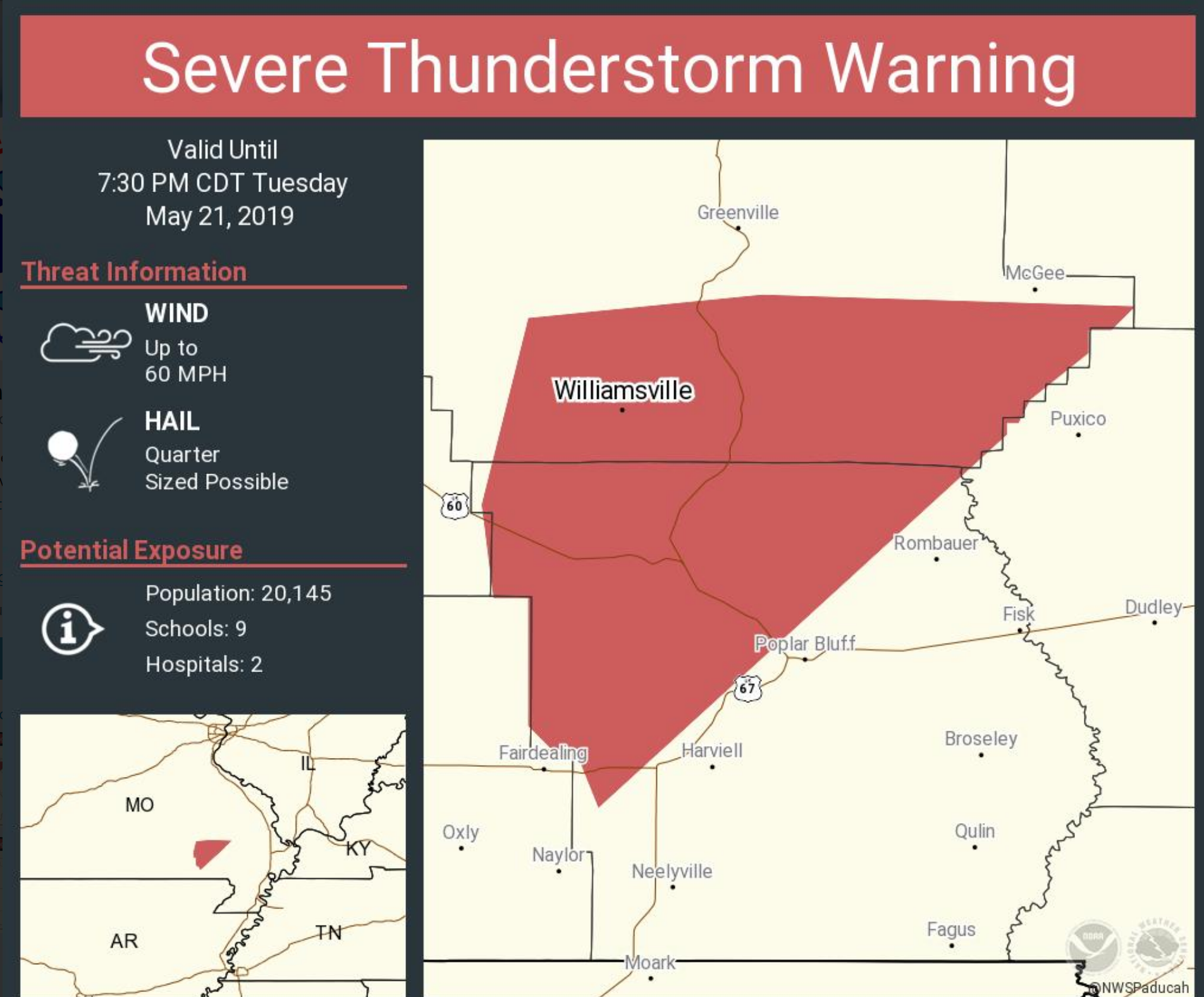
Severe Thunderstorm Warning [wind: 60 MPH, hail: 0.75 IN] for Crawford, Franklin, Iron, Jefferson, Madison, Reynolds, St. Francois, Ste. Genevieve, Washington [MO] till 7:15 PM CDT

.
5:52 PM
PAH continues Severe Thunderstorm Warning [tornado: POSSIBLE, wind: 60 MPH, hail: 0.75 IN] for Carter, Ripley [MO] till 6:15 PM CDT
5:49 PM
SPC update concerning the tornado watch.


.
5:21 PM
Severe Thunderstorm Warning [tornado: POSSIBLE, wind: 60 MPH, hail: 0.75 IN] for Carter, Ripley [MO] till 6:15 PM CDT
Severe Thunderstorm Warning
National Weather Service Paducah KY
521 PM CDT Tue May 21, 2019
The National Weather Service in Paducah has issued a
* Severe Thunderstorm Warning for…
Western Carter County in southeastern Missouri…
Western Ripley County in southeastern Missouri…
* Until 615 PM CDT.
* At 520 PM CDT, severe thunderstorms were located along a line
extending from near Winona to near Alton to near Mammoth Spring,
moving northeast at 40 mph.
HAZARD…60 mph wind gusts and penny size hail.
SOURCE…Radar indicated.
IMPACT…Expect damage to roofs, siding, and trees.
* Locations impacted include…
Van Buren, Gatewood, Handy, Fremont and Briar.
.
5:05 PM
The forecast is on track.
The greatest risk of severe storms over the coming hours will be SE MO and then SW IL. The line is forecast to rapidly weaken later tonight as the better wind shear pulls away to the north.
It will be a race against time between that happening and the line weakening.
5:00 PM
A weather watch is unlikely for the MO Bootheel. Severe storms are, however, possible.


.
4:50 PM
4:50 PM CAPE has likely peaked. The air is unstable ahead of this squall line. It will remain severe for several more hours. Isolated tornadoes are possible.
CAPE is basically energy for storms to tap into.

.
4:34 PM
A bit to the west of my forecast area.
Local Storm Report by NWS Sringfield: 3 SW Edgar Springs [Phelps Co, MO] public reports TORNADO at 04:25 PM CDT — tornado on the ground southwest of edgar springs. debris being picked up in the air at the moment. small elephant trunk tornado.
.
3:45 PM
The Ohio Valley video team has posted an update. Remember, this covers a much larger area than just my local counties.
.
3:38 PM
Live radar CLICK HERE
A line of storms is approaching southeast Missouri from the west. The line is moving E NE.
You can see it on this radar.
There are embedded tornadoes in the line.


The NWS continues Tornado Warning [tornado: OBSERVED, hail: 1.75 IN] for Wright [MO] till 3:45 PM CDT …AT 334 PM CDT, A CONFIRMED TORNADO WAS LOCATED NEAR HARTVILLE, OR 16 MILES NORTHWEST OF MOUNTAIN GROVE, MOVING NORTHEAST AT 50 MPH.
.
3:15 PM
A new tornado watch has been issued until 10 PM for SE MO and SW IL
Click on the images to enlarge them.


.
3:00 PM Update
Discussion from SPC.
The line of storms is becoming more supercells vs being a line. Here is the latest.


.
1:35 PM
Here are some of the parameters coming together for severe thunderstorms.
Anytime we have sunshine that equates to warmer temperatures (this time of the year).
Warmer temperatures when combined with high dew points (moisture in the air) you have higher CAPE numbers. Think of CAPE as energy for storms to tap into.
Here is the satellite.

.
Here are the latest CAPE numbers
Notice the higher CAPE numbers are where the clouds have thinned. This is also south of the warm front.

Dew points have rapidly increased over the last four hours.
Dew points are moisture in the air. Higher dew points usually mean stronger thunderstorms and heavier rain.

.
Here is the warm front. The warm front is the red half moons. That is the boundary moving northward.
Stronger storms typically occur along and south of the warm front.

.
Temperatures have rapidly risen south of the warm front. Almost 90 across portions of the area. Much cooler north of the warm front. Notice that Mt Vernon is 63 degrees and northwest Tennessee is near 90.

.
See the boundary in western Kentucky? Boundaries need to be watched during severe weather. Keep in mind, this boundary is slowly lifting northward.
It will move into southern Illinois later today.

.
EHI numbers are spiking along and south of the warm front.
EHI is spin in the atmosphere (basically)

.
1:05 PM
A new tornado watch has been issued.


.
11:05 AM
Check out the agreement among all the high-res models. This is 8 PM tonight and all of them show the same idea.
The more agreement the higher the confidence levels.
Click to enlarge.

.
11:00 AM
Some of the model data suggest a few isolated storms form ahead of the main line. IF that happens then the timetable for storms would need adjusting. Keep that in mind.
4 PM radar shot from the WRF model.

.
10:45 AM
A new tornado watch will be issued shortly.
This watch may be just a tad west of my forecast area. A new watch is likely later today, as well.

Click above and below to enlarge these images/text.

10:30 AM Update
Here are the latest morning model runs.
Notice how fast this thing fall apart tonight? Rapidly decreasing as it moves east.
Keep that in mind. Not everyone will have severe storms. The main concern is southeast Missouri and southwest Illinois.
Time-stamp is located at the upper left.
These are different models. Notice they generally have the same idea.
We will need to monitor for any discrete supercells that form ahead of the line. Supercell storms can produce all modes of severe weather.
Click images to enlarge them.


.
10:00 AM Update
Severe storms are likely later this afternoon and tonight.
The main concern will be across southeast Missouri and southwest Illinois. The line is forecast to weaken as it moves further east.
Satellite shows the clearing line where the atmosphere is heating up and becoming unstable. Remember, sun = more instability.
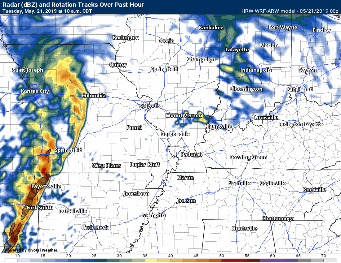
Radar shows the line of storms well to our west. It is moving eastward.

.
Dew points are rising south of the boundary (where clearing is occurring). Dew points are a measure of moisture in the atmosphere. It is a better gauge than humidity.

.
CAPE values are rising. CAPE is energy for storms. Notice how the higher dew points, the clearing, and the higher CAPE values line up.

..
Click one of the links below to take you directly to each section.
- Go to storm tracking tools. Radars, lightning, & satellite.
- Go to today’s forecast
- Go to the city-view graphic-casts
- Go to the severe weather outlook
- Go to the weather forecast discussion
- Go to the model future-cast radars
- Go to videos
- Go to weeks one, two, three, and four temperature & precipitation graphics
- Go to spring and summer outlooks.
- Go to Weatherbrains
- View our community charity work. Your subscription dollars help support these causes.
- County maps. I made a page with county maps. Some of you requested this.
Do you have questions or suggestions? If so, please email me. Beaudodson@usawx.com
.
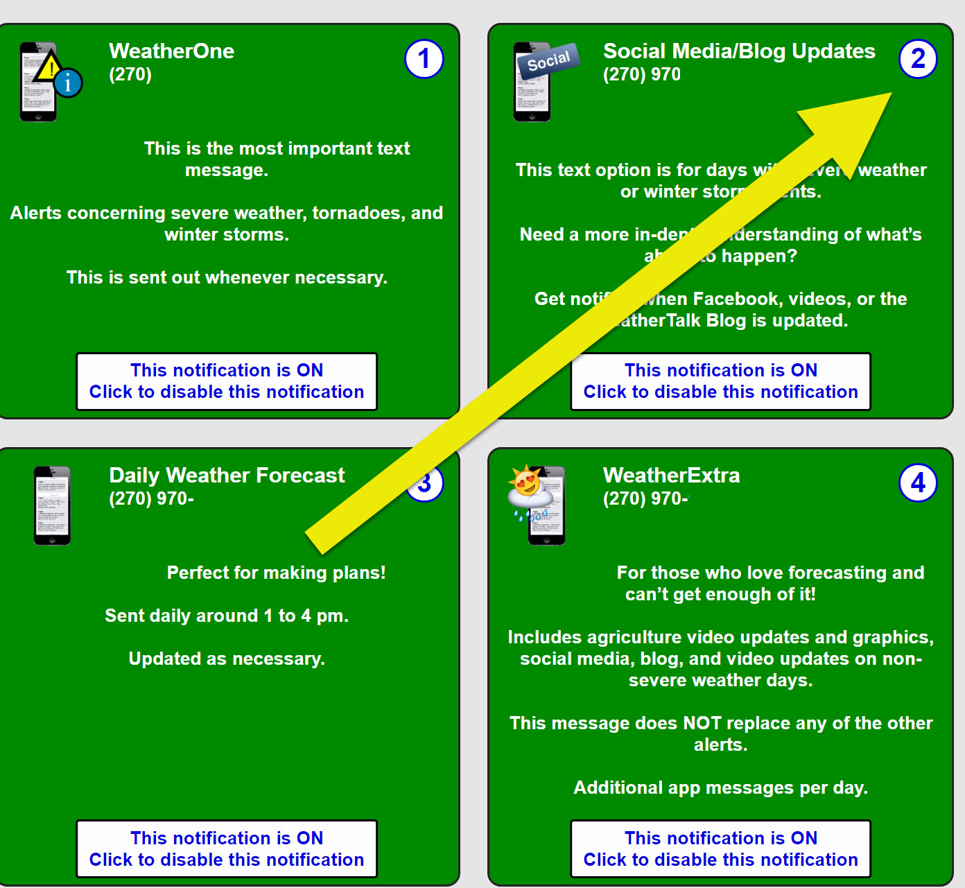
Not receiving app/text messages?
Make sure you have the correct app/text options turned on. Find those under the personal notification settings tab at www.weathertalk.com. Red is off. Green is on.
Subscribers, PLEASE USE THE APP. ATT and Verizon are not reliable during severe weather. They are delaying text messages.
The app is under Beau Dodson Weather in the app store.

Apple users click here

Android users click here


Tuesday: Monitor. Some lightning during the morning hours. Severe thunderstorms are possible late in the day on Tuesday and more likely Tuesday night. The main concern will be over southeast Missouri and southern Illinois. Tornadoes are possible. QLCS tornadoes. These are usually short lived but can cause EF0, EF1, and EF2 wind speeds. A tornado is a tornado.
Wednesday: Monitor. Storms may linger into Wednesday. A few could be strong.
Thursday: A slight chance of lightning.
Friday: No
Saturday: No
Sunday: No
Monday: No
.3

- More of the same. The main problem has been wet ground conditions.
- Some of the storms on Tuesday afternoon and night could produce very heavy rain and even hail. I will be monitoring the risk of damaging wind gusts, as well.
- River flooding continues in many areas. Low-land flooding.
.
.
Click here if you would like to return to the top of the page
.

Tuesday through Thursday
- Is lightning in the forecast? Yes. I will be monitoring a line of storms approaching from Missouri after 3 AM (Tuesday morning). Some lightning is possible. Lightning is likely on Tuesday late afternoon into Tuesday night. I will be monitoring the late afternoon hours over southeast Missouri, as well. I will be monitoring a line of storms approaching from Missouri after 3 AM (Tuesday morning). Lightning is possible on Wednesday and Wednesday evening. An isolated lightning strike is possible Thursday afternoon.
- Is severe weather in the forecast? Yes. Likely. Severe storms are possible Tuesday evening/Tuesday night. I will be monitoring the late afternoon hours over southeast Missouri, as well. All modes of severe weather will be possible if the atmosphere can recover from the morning showers and thunderstorms/clouds. A strong storm is possible on Wednesday. Monitor updates.
* The NWS officially defines severe weather as 58 mph wind or great, 1″ hail or larger, and/or tornadoes - Is flash flooding in the forecast? Monitor. Storms will produce heavy rain. Isolated flooding issues may develop.
.

Friday through Monday
- Is lightning in the forecast? Low risk. An isolated thunderstorm is possible during the heat of the day. The best chance (even that is small) will be on Monday.
- Is severe weather in the forecast? No.
* The NWS officially defines severe weather as 58 mph wind or great, 1″ hail or larger, and/or tornadoes - Is flash flooding in the forecast? No
.

.
* The Missouri Bootheel includes Dunklin, New Madrid, and Pemiscot Counties
* Northwest Kentucky includes Daviess, Henderson, McLean Union, and Webster Counties
County Maps: Click Here
.
ATTENTION. A major app update will be released soon. Watch for announcements.
.
Have there been any changes in the forecast over the last 24 hours?
I added a slight chance of lightning on Thursday. Low confidence.
I removed the mention of thunderstorms Saturday. Monitor updates since it will be warm and muggy. Sometimes, isolated storms can pop up in this type of air-mass. No organized storms are forecast.
.
What changes might occur in the forecast?
How far east will the thunderstorm progress tonight? Some storms could be severe over southeast Missouri and southern Illinois. Whether these storms can survive further east is still a question. Monitor.
.
May 21, 2019
Tuesday’s Forecast: Temperatures today will be highly dependent on the clouds and showers coming to an end this morning. Temperatures, across portions of the region, are cooler than anticipated this morning. A band of showers and weakening thunderstorms will push into the area Tuesday morning. A few spotty showers and storms will be possible Tuesday afternoon, as well. Increasing clouds from the west during the afternoon. I will be monitoring a developing line of severe thunderstorms in western and central Missouri and Arkansas. This line will push eastward during the late afternoon and evening hours. Some of these storms will be severe.
My confidence in the forecast verifying: Medium (60% confidence in the forecast))
Temperature range: MO Bootheel 83° to 86° SE MO 80° to 84° South IL 80° to 84° Northwest KY (near Indiana border) 83° to 86° West KY 86° to 88° NW TN 86° to 88°
Wind direction and speed: Southeast wind at 15 to 30 mph. Gusty winds in the afternoon.
Wind chill or heat index (feels like) temperature forecast: 84° to 90°
What is the chance/probability of precipitation? MO Bootheel 60% Southeast MO 60% IL 40% Northwest KY (near Indiana border) 30% Western KY 40% NW TN 40%
Note, what does the % chance actually mean? A 20% chance of rain does not mean it won’t rain. It simply means most areas will remain dry.
Coverage of precipitation: Numerous during the morning hours, especially over southeast Missouri and southern Illinois. Scattered elsewhere.
What impacts are anticipated from the weather? Some storms could be intense late in the day and more likely Tuesday night. Lightning large hail, damaging wind, and tornadoes will be possible with the most intense storms. This will most likely be over portions of southeast Missouri and southwest Illinois. Mainly towards late in the day into Tuesday night.
Should I cancel my outdoor plans? Go about your business but monitor afternoon updates.
UV Index: 8 to 9 Very high
Sunrise: 5:42 AM
.
Tuesday night Forecast: A line of showers and thunderstorms pushing from west to east. Some storms will be severe. The main concern will be over southeast Missouri and southern Illinois. We will need to monitor the rest of the area for severe storms, as well. Even though the line may be weakening it could still produce some damaging wind gusts as it moves eastward. Monitor updates through the day and night.
My confidence in the forecast verifying: High (70% confidence in the forecast)
Temperature range: MO Bootheel 64° to 68° SE MO 60° to 65° South IL 64° to 68° Northwest KY (near Indiana border) 64° to 68° West KY 66° to 70° NW TN 66° to 70°
Wind direction and speed: South at 15 to 25 mph. Gusty.
Wind chill or heat index (feels like) temperature forecast: 64° to 68°
What is the chance/probability of precipitation? MO Bootheel 100% Southeast MO 100% IL 90% Northwest KY (near Indiana border) 60% Western KY 80% NW TN 80%
Note, what does the % chance actually mean? A 20% chance of rain does not mean it won’t rain. It simply means most areas will remain dry
Coverage of precipitation: Becoming numerous with a line of storms moving in from the west.
What impacts are anticipated from the weather? Lightning large hail, damaging wind, and tornadoes will be possible with the most intense storms. The main concern will be over southeast Missouri and southwest Illinois. Elsewhere, monitor updates.
Should I cancel my outdoor plans? Have a plan B. Monitor updates.
Sunset: 8:02 PM
Moonrise: 10:57 PM
The phase of the moon: Waning Gibbous
Moonset: 7:58 AM
.
.
May 22, 2019
Wednesday’s Forecast: A mix of sun and clouds. A few showers and thunderstorms are possible. Warm. Humid.
My confidence in the forecast verifying: Medium (40% confidence in the forecast))
Temperature range: MO Bootheel 82° to 84° SE MO 82° to 84° South IL 80° to 84° Northwest KY (near Indiana border) 80° to 84° West KY 80° to 84° NW TN 84° to 86°
Wind direction and speed: South and southwest 10 to 20 mph. Gusty wind at times.
Wind chill or heat index (feels like) temperature forecast: 84° to 88°
What is the chance/probability of precipitation? MO Bootheel 40% to 50% Southeast MO 40% to 50% IL 40% to 50% Northwest KY (near Indiana border) 40% to 50% Western KY 40% to 50% NW TN 40% to 50%
Note, what does the % chance actually mean? A 20% chance of rain does not mean it won’t rain. It simply means most areas will remain dry.
Coverage of precipitation: Scattered
What impacts are anticipated from the weather? Wet roadways. Lightning.
Should I cancel my outdoor plans? No, but monitor radars.
UV Index: 8 High
Sunrise: 5:41 AM
.
Wednesday night Forecast: Partly cloudy. Patchy fog. Mild for May. Humid. An evening thunderstorm possible.
My confidence in the forecast verifying: Medium (60% confidence in the forecast)
Temperature range: MO Bootheel 66° to 70° SE MO 66° to 70° South IL 66° to 70° Northwest KY (near Indiana border) 66° to 70° West KY 66° to 70° NW TN 68° to 72°
Wind direction and speed: South and southeast 7 to 14 mph.
Wind chill or heat index (feels like) temperature forecast: 70° to 72°
What is the chance/probability of precipitation? MO Bootheel 20% Southeast MO 20% IL 20% Northwest KY (near Indiana border) 20% Western KY 20% NW TN 20%
Note, what does the % chance actually mean? A 20% chance of rain does not mean it won’t rain. It simply means most areas will remain dry
Coverage of precipitation: None for most. I will monitor northern portions of southern Illinois for a storm or two.
What impacts are anticipated from the weather? Monitor lower visibility if fog forms. A slight chance of lightning and wet roadways near Mt Vernon.
Should I cancel my outdoor plans? No
Sunset: 8:03 PM
Moonrise: 11:46 PM
The phase of the moon: Waning Gibbous
Moonset: 8:50 AM
.
.
May 23, 2019
Thursday’s Forecast: Mostly sunny. Quite warm. Humid. A slight chance of a thunderstorm.
My confidence in the forecast verifying: Medium (60% confidence in the forecast))
Temperature range: MO Bootheel 86° to 90° SE MO 86° to 90° South IL 85° to 90° Northwest KY (near Indiana border) 85° to 90° West KY 78° to 82° NW TN 86° to 90°
Wind direction and speed: South and southwest at 5 to 10 mph
Wind chill or heat index (feels like) temperature forecast: 86° to 94°
What is the chance/probability of precipitation? MO Bootheel 20% Southeast MO 20% IL 20% Northwest KY (near Indiana border) 20% Western KY 20% NW TN 20%
Note, what does the % chance actually mean? A 20% chance of rain does not mean it won’t rain. It simply means most areas will remain dry.
Coverage of precipitation: None to isolated
What impacts are anticipated from the weather? None for most. Isolated wet roads and isolated lightning.
Should I cancel my outdoor plans? No, but check afternoon radars.
UV Index: 9 to 10 Very high
Sunrise: 5:40 AM
.
Thursday night Forecast: A few evening clouds with an isolated evening thunderstorm. Patchy fog. Mild. Humid.
My confidence in the forecast verifying: Medium (60% confidence in the forecast)
Temperature range: MO Bootheel 66° to 70° SE MO 66° to 70° South IL 66° to 70° Northwest KY (near Indiana border) 66° to 70° West KY 66° to 70° NW TN 68° to 72°
Wind direction and speed: South at 4 to 6 mph
Wind chill or heat index (feels like) temperature forecast: 70° to 72°
What is the chance/probability of precipitation? MO Bootheel 20% Southeast MO 20% IL 20% Northwest KY (near Indiana border) 20% Western KY 20% NW TN 20%
Note, what does the % chance actually mean? A 20% chance of rain does not mean it won’t rain. It simply means most areas will remain dry
Coverage of precipitation: None to isolated
What impacts are anticipated from the weather? Monitor lower visibility if fog forms. Isolated wet roads and isolated lightning.
Should I cancel my outdoor plans? No, but check evening radars
Sunset: 8:04 PM
Moonrise: 11:59 PM
The phase of the moon: Waning Gibbous
Moonset: 9:44 AM
.
Friday: High confidence. Mostly sunny. Some cumulus clouds. Warm and muggy. High temperatures in the upper 80s to around 90 degrees. Low temperatures in the upper 60s to lower 70s. South and southwest winds at 6 to 12 mph.
.
Saturday: High confidence. Mostly sunny. Some cumulus clouds. Warm and muggy. High temperatures in the upper 80s to around 90 degrees. Low temperatures in the upper 60s to lower 70s. South and southwest winds at 7 to 14 mph.
.
Sunday: Medium confidence. Partly to mostly sunny. High temperatures in the upper 80s to around 90. Low temperatures in the upper 60s. South and southwest winds at 7 to 14 mph.
Monday: Medium confidence. Mostly sunny. Warm and humid. An isolated storm is possible. High temperatures in the upper 80s to around 90. Low temperatures in the upper 60s to around 70. South and southwest winds at 6 to 12 mph.
.
Learn more about the UV index readings. Click here.
.
Wind forecast


.
Click images to enlarge them


.
.
Graphic-cast
Click here if you would like to return to the top of the page
.
** These graphic-forecasts may vary a bit from my forecast above **
CAUTION: I have these graphics set to auto-update on their own. Make sure you read my hand-typed forecast above.
During active weather check my handwritten forecast.
.
Missouri


.
Illinois
** These graphic-forecasts may vary a bit from my forecast above **
CAUTION: I have these graphics set to auto-update on their own. Make sure you read my hand-typed forecast above.
During active weather check my handwritten forecast.


.
Kentucky
** These graphic-forecasts may vary a bit from my forecast above **
CAUTION: I have these graphics set to auto-update on their own. Make sure you read my hand-typed forecast above.
During active weather check my handwritten forecast.


.
Tennessee
** These graphic-forecasts may vary a bit from my forecast above **
CAUTION: I have these graphics set to auto-update on their own. Make sure you read my hand-typed forecast above.
During active weather check my handwritten forecast.


.
.
The National Weather Service defines a severe thunderstorm as one that produces quarter size hail or larger, 58 mph winds or greater, and/or a tornado.
.
Tuesday: Morning storms should be sub-severe. Thunderstorms will push into the region later this evening and tonight. The main concern will be across southeast Missouri and southern Illinois. Elsewhere, monitor updates. Some storms could be intense with hail, high winds, and tornadoes.
Wednesday: A few storms will linger into Wednesday. If storms do occur then a few could be strong.
Thursday: Severe storms are not anticipated. Small chance of lightning.
Friday: Severe storms are not anticipated.
Saturday: Severe storms are not anticipated.
Sunday: Severe storms are not anticipated.
Monday: Severe storms are not anticipated. Isolated lightning.
.
Click here if you would like to return to the top of the page
Today’s outlook (below).
Light green is where thunderstorms may occur but should be below severe levels.
Dark green is a level one risk. Yellow is a level two risk. Orange is a level three (enhanced) risk. Red is a level four (moderate) risk. Pink is a level five (high) risk.
One is the lowest risk. Five is the highest risk.
Light green is not assigned a number. Light green is where storms may occur but should be below severe levels.
A severe storm is one that produces 60 mph winds or higher, quarter size hail, and/or a tornado. One or more of those is defined as a severe thunderstorm.

The black outline is our local area.

.
Tomorrow’s outlook.
Light green is where thunderstorms may occur but should be below severe levels.
Dark green is a level one risk. Yellow is a level two risk. Orange is a level three (enhanced) risk. Red is a level four (moderate) risk. Pink is a level five (high) risk.
One is the lowest risk. Five is the highest risk. Light green is not assigned a number.


.
Be sure and have WeatherOne turned on in your WeatherTalk accounts. That is the one for tornadoes, severe storms, and winter storms.
Log into your www.weathertalk.com
Click the personal notification settings tab.
Turn on WeatherOne. Green is on. Red is off.

.

Here is the latest graphic from the WPC/NOAA.
.
24-hour precipitation outlook.
.

.
48-hour precipitation outlook.
.
.
.
72-hour precipitation outlook.
.

.
Days one through seven added together. Seven-day rainfall totals.

.

.
- Tuesday’s storms are the main topic.
- Quite warm through Memorial Day weekend.
.
Current conditions.

.
Click here if you would like to return to the top of the page
.
![]()
.
Weather
.
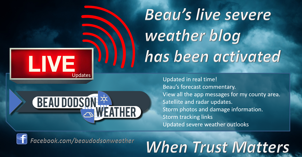
Subscribers, I want to draw your attention to something new that I am doing.
I am posting a live blog feed during severe weather events. The information being posted includes my now-cast, frequent updates concerning radar and satellite trends, NOAA/SPC information, warning information, and more.
This comes with your subscription.
.
3. Look for the words LIVE LINK IS ACTIVE
Today into Tuesday night:
We will have morning showers and thunderstorms. The greatest coverage will be across southeast Missouri and southern Illinois.
See the live interactive city-view radars.
This dying area of showers and thunderstorms will leave some clouds around the area through the day.
A boundary will be draped across our region later today and tonight. This boundary will enhance severe thunderstorms. We will need to monitor the placement of the boundary for tornadoes, as well.
The boundary should be between St Louis and Perryville, MO and then east northeast of there.
Outside of that boundary, there will be numerous showers and thunderstorms, as well. Some will likely be severe.
A few pop-up showers and thunderstorms will be possible at any given point today, however, the main show will be later this evening into Tuesday night.
A severe weather event is likely to impact at least portions of our region later today and tonight.
Large hail, damaging wind, and tornadoes will be possible with a line of thunderstorms that will sweep into eastern Missouri and parts of southern Illinois late Tuesday afternoon into Tuesday night.
The line will then weaken as it continues to move further east. How fast it weakens will determine how far east the severe weather threat will continue. That will be a now-cast. The word now-cast means it will be forecasted in the 4 to 8-hour range as conditions unfold.
For now, monitor updates throughout the day into tonight. I will have the live blog feed going.
If any supercells form ahead of the line then they could produce strong tornadoes and a higher end severe weather event. This will need to be monitored closely.
Click images to enlarge them.
This is a QLCS. A line of thunderstorms with segments and bowing segments. Typically, these produce damaging winds and short-lived tornadoes that are often times embedded in the rain.
You can see the WRF model guidance depicts that squall line (line of thunderstorms) quite well.
It marches off to the east and northeast.
A severe thunderstorm or tornado watch is likely to be issued for at least portions of our region later today and tonight.
Some warnings are also likely. Monitor my live severe weather feed later today.
Click to enlarge. Timestamp upper left.
.
Wednesday through Sunday
We may have some showers and thunderstorms lingering into Wednesday and perhaps early Wednesday night.
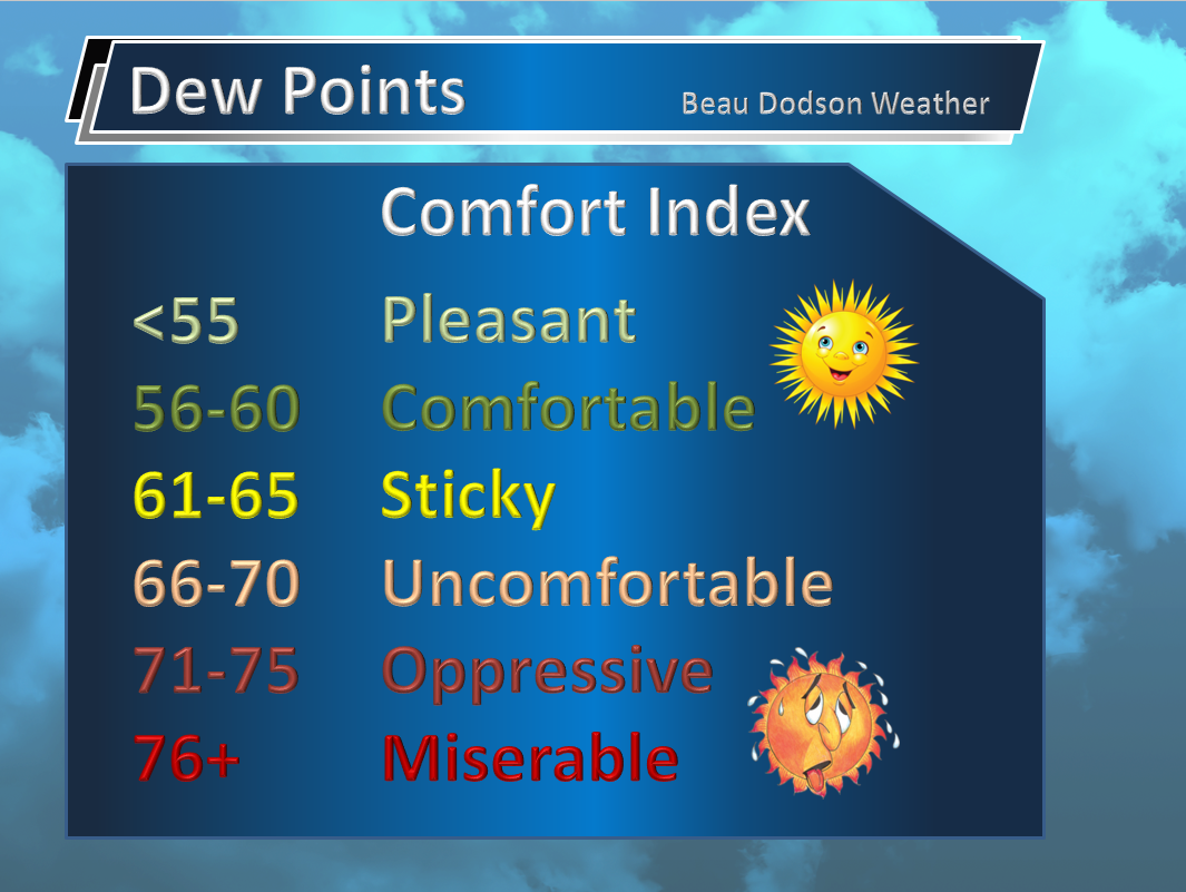
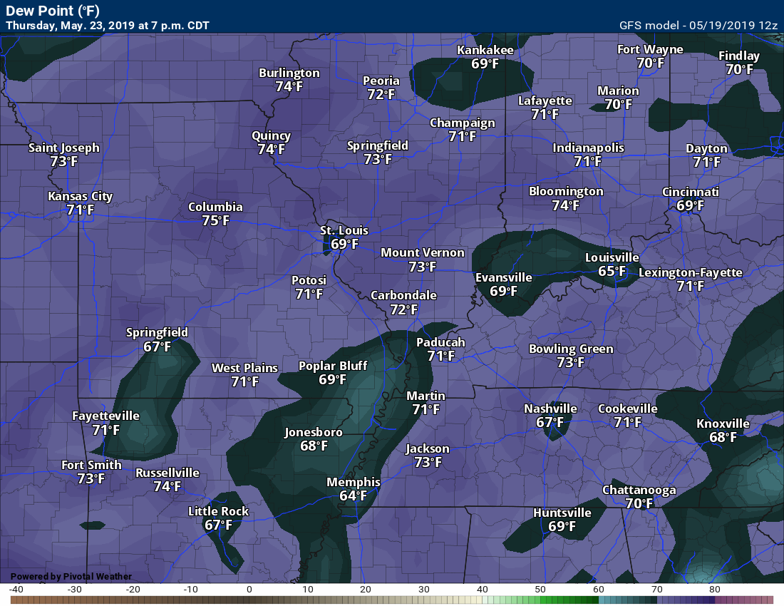
Quite warm and muggy weather will also develop Wednesday into the weekend. Temperatures will rise into the upper 80s and perhaps lower 90s. Dew points will jump into the upper 60s to around 70 degrees. That is muggy air. It won’t feel like May.
Check out these dew points. These are the type of dew points that we typically see in July or August. Not May!
70-degree dew points are uncomfortable. Air you wear (as Jim Rasor says).
.
Wednesday afternoon/night.

Thursday afternoon and evening.
.
There is a small chance of storms Thursday afternoon and night. Perhaps the greater chance on Thursday night will be closer to St Louis to Mt Vernon.
For now, I have Friday through Monday as mostly dry. There is always a small chance of an isolated thunderstorm in the heat of the day. For the vast majority of the region, we should remain dry.
I am monitoring the model guidance concerning a boundary that may fluctuate near our region (see the GFS model animation below). Most likely a tad to the north, but close enough that we need to monitor it.
That boundary will be the focus of showers and storms. If the boundary drifts southward then our rain chances will increase.
I will be monitoring this portion of the forecast.
 .
.
Click here if you would like to return to the top of the page
.
Again, as a reminder, these are models. They are never 100% accurate. Take the general idea from them.
Look for continuity among the models. The more models that agree, the higher the confidence in the forecast.
.
These will be updated Tuesday morning as new data arrives.
First, let me show you the Hrrr model. This is a high-resolution model.
It is showing a band of showers and storms late Monday night. Weakening as it moves into our region.
I am going to monitor that portion of the forecast. Other models are dry.

and this is the SPC WRF model guidance

.
Here is the lower resolution NAM model and then the higher resolution NAM 3K below it.
Timestamp upper left.
Click the animations to enlarge them.
Let’s monitor Tuesday afternoon and night for some intense thunderstorms.


.
Looking even further out. The GFS is a long-range model.
The GFS model is a lower resolution model. It makes the rain coverage appear larger.
Timestamp upper left. Click the animation to enlarge it.

.
These maps update several times a day. Occasionally, in between updates, you may see a duplicate day or one out of sync.
Forty-eight-hour temperature outlook.


*****
![]()
These are bonus videos and maps for subscribers. I bring these to you from the BAMwx team. I pay them to help with videos.
The Ohio and Missouri Valley videos cover most of our area. They do not have a specific Tennessee Valley forecast but they may add one in the future.
The long-range video is a bit technical. Over time, you can learn a lot about meteorology from the long range video.

.
Click here if you would like to return to the top of the page
These are bonus videos for subscribers.
I pay BAMwx to help with videos.
They do not currently have a Kentucky/Tennessee specific video.
The Ohio Valley video does capture our region.
,
The Ohio Valley video
.

.

Missouri Valley
.![]() .
.

I bring the following long-range outlooks from the BAMwx team. They are excellent long-range forecasters. These are more detailed than the images above.
Remember, long-range outlooks are always going to be a lower confidence level than short-term forecasts.
Long-range forecasting is not an exact science. There are many variables that determine the eventual outcome of a long-range forecast.
.
Key Points:
- Heavy rainfall over the last 24 hours was focused in much of Kansas, especially southeast Kansas, into western Missouri. Higher totals were also noted in southwestern South Dakota into north-central Nebraska.
- Models continue to suggest a persistent southeast ridge with a western trough in the week 1 period. This set up will allow for above normal temperatures in eastern portions of the Ag Belt with below normal temperatures in the northern and western portions. The models begin to diverge slightly in the week 2 period, likely due to their progression of the MJO, with the EPS beginning to bleed some of the cooler eastward and the GEFS strengthening the southeast ridge and expanding the heat westward.
- The set-up continues to keep much of the Ag Belt at a greater risk for above-average precipitation in the week 1 period. For the week 2 period, the EPS solution suggests a slight eastward shift of above average precipitation and a drier pattern in the northern Plains while the GEFS continues the current pattern that has much of the Ag Belt experiencing above average accumulation.
- We tend to favor the EPS solution due to the current progression of the MJO.
- A very active period of weather is expected for the remainder of May as noted in our Storm Dates. This will allow for an increased precipitation risk for much of the Ag Belt. Storm-induced warming will also be seen ahead of these systems allowing for further warming, especially in eastern and southern portions of the Ag Belt.
.


.

Click here if you would like to return to the top of the page
.
Normal high temperatures for this time of the year are around 77 degrees.
Normal low temperatures for this time of the year are around 56 degrees.
Normal precipitation during this time period ranges from 0.90″ to 1.20″
Yellow and orange are above normal. Red is much above normal. Light blue and blue is below normal. Green to purple is much below normal.
This outlook covers May 21st through the 28th

The precipitation forecast is PERCENT OF NORMAL. Brown is below normal. Green is above normal. Blue is much above normal.
.


Outlook definitions
EC = Equal chances of above or below normal
BN= Below normal
M/BN = Much below normal
AN = Above normal
M/AN = Much above normal
E/AN = Extremely above normal
Normal low temperatures for this time of the year are around 58 degrees
Normal precipitation during this time period ranges from 0.90″ to 1.20″
.
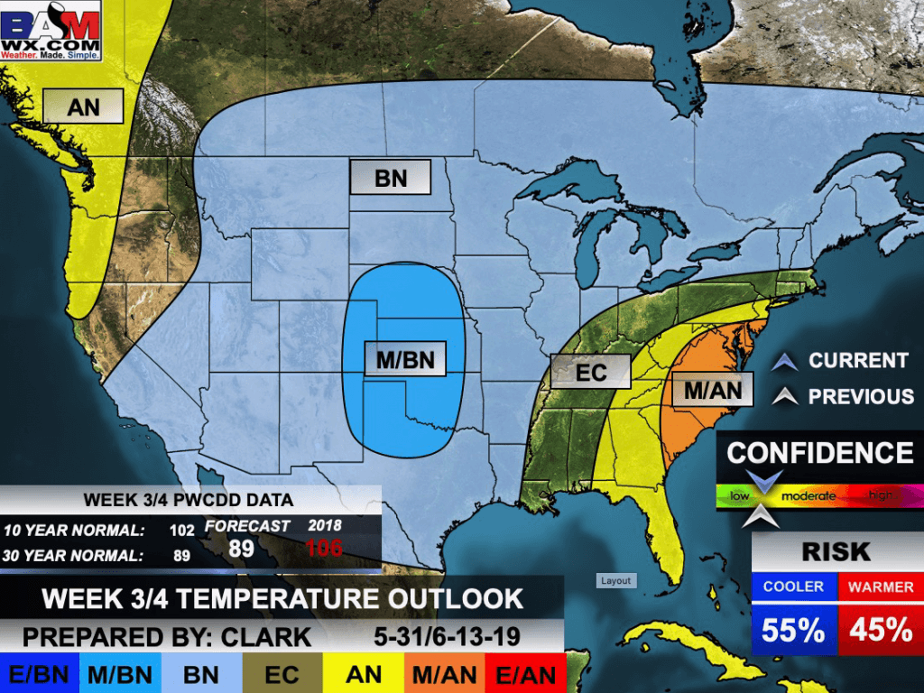
This outlook covers May 25th through May 31st
.

.
The precipitation forecast is PERCENT OF NORMAL. For example, if your normal rainfall is 1.00″ and the graphic shows 25%, then that would mean 0.25″ of rain is anticipated.
.


Outlook definitions
EC = Equal chances of above or below normal
BN= Below normal
M/BN = Much below normal
AN = Above normal
M/AN = Much above normal
E/AN = Extremely above normal
Normal high temperatures for this time of the year are around 82 degrees
Normal low temperatures for this time of the year are around 60 degrees
Normal precipitation during this time period ranges from 1.70″ to 2.40″
.
This outlook covers May 24th through June 6th
.
.
The precipitation forecast is PERCENT OF NORMAL. For example, if your normal rainfall is 1.00″ and the graphic shows 10%, then that would mean 0.10″ of rain is anticipated.
.

.

AND

Click here to go to the top of the page
.
Outlook definitions
EC= Equal chances of above or below normal
BN= Below normal
M/BN = Much below normal
AN = Above normal
M/AN = Much above normal
E/AN = Extremely above normal
.
May temperature and precipitation outlook


.

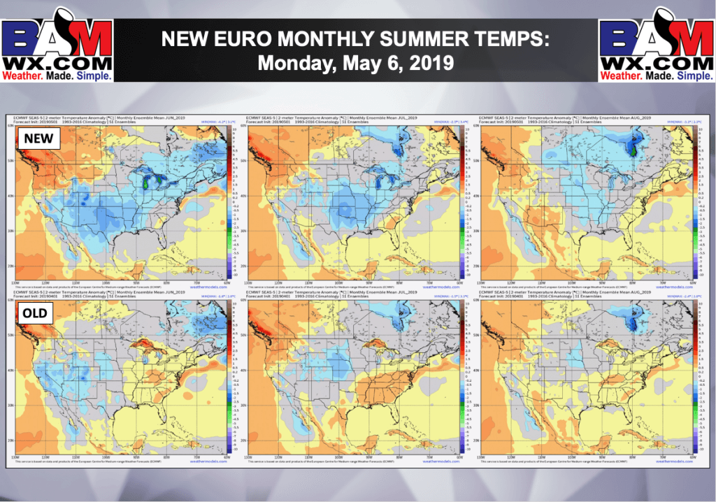
Euro is a model.
Blue is below normal temps. Yellow/orange are above normal temps.
.
June temperature outlook

June precipitation outlook

.
July temperature outlook

.
July precipitation outlook
.
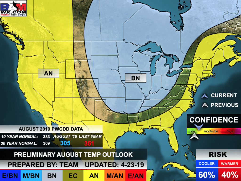
August temperature outlook
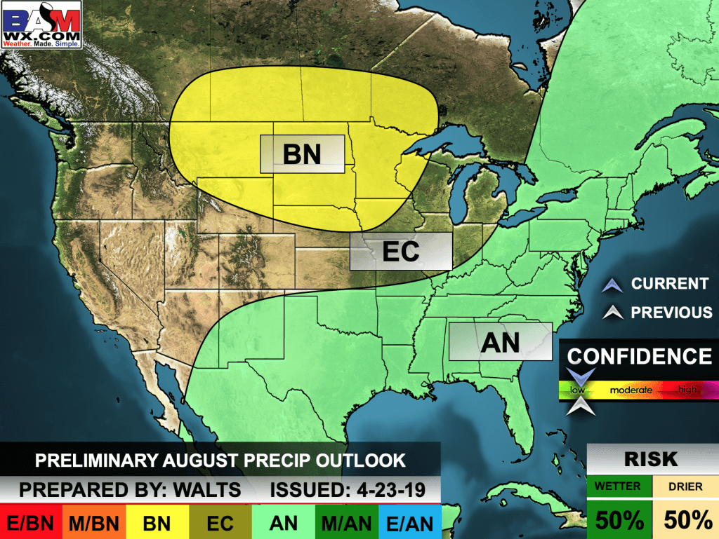
August precipitation outlook
.
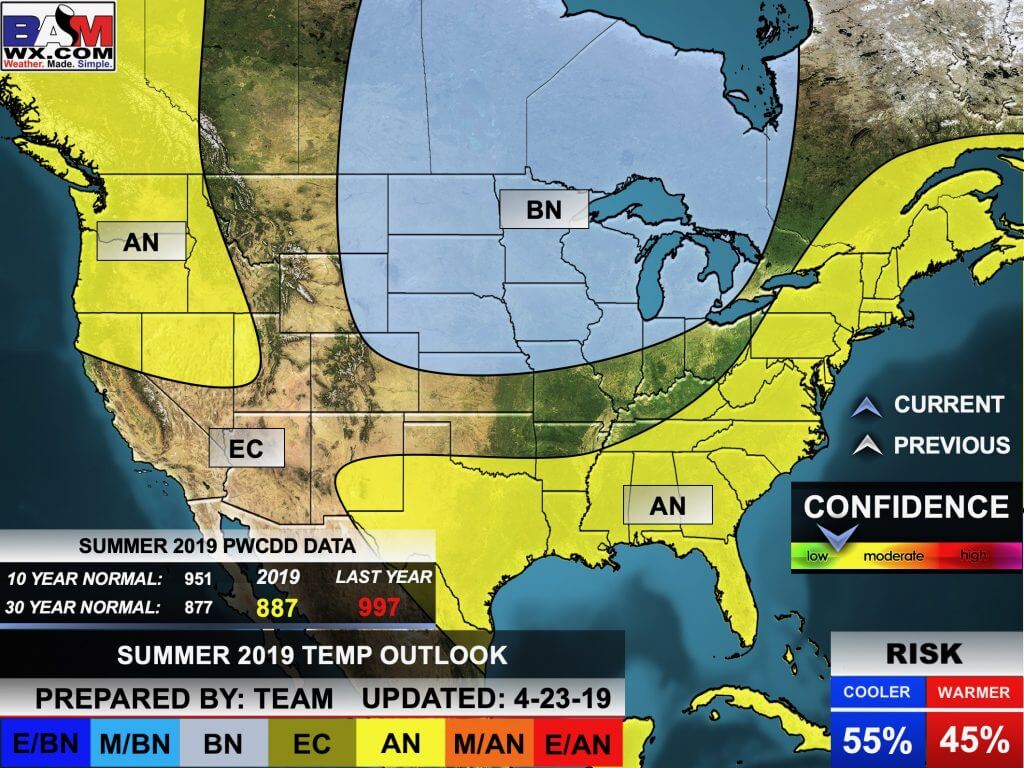
Preliminary summer outlook

.
.
Radar Link: Interactive local city-view radars & regional radars.
You will find clickable warning and advisory buttons on the local city-view radars.
If the radar is not updating then try another one. If a radar does not appear to be refreshing then hit Ctrl F5. You may also try restarting your browser.
Not working? Email me at beaudodson@usawx.com
National map of weather watches and warnings. Click here.
Storm Prediction Center. Click here.
Weather Prediction Center. Click here.
.

Live lightning data: Click here.
.

Interactive GOES R satellite. Track clouds. Click here.
GOES 16 slider tool. Click here.
College of Dupage satellites. Click here
.

Here are the latest local river stage forecast numbers Click Here.
Here are the latest lake stage forecast numbers for Kentucky Lake and Lake Barkley Click Here.
.
Did you know that you can find me on Twitter? Click here to view my Twitter weather account.

.

.
Who do you trust for your weather information and who holds them accountable?
I have studied the weather in our region since the late 1970s. I have 40 years of experience in observing our regions weather patterns.
My degree is in Broadcast Meteorology from Mississippi State University and a Bachelor of Science (BS).
I am an NOAA Weather-Ready Nation Ambassador. I am the Meteorologist for McCracken County rescue squad. When asked, I assist Ballard and Massac Counties, as well.
I own and operate the Southern Illinois Weather Observatory and WeatherTalk LLC.
There is a lot of noise on the internet. Over time you should learn who to trust for your weather information.
My forecast philosophy is simple and straight forward.
- Communicate in simple terms
- To be as accurate as possible within a reasonable time frame before an event
- Interact with you on Twitter, Facebook, and the blog
- Minimize the “hype” that you might see on television or through other weather sources
- Push you towards utilizing wall-to-wall LOCAL TV coverage during severe weather events
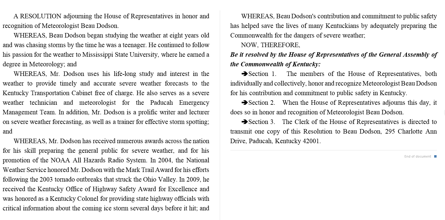
I am a recipient of the Mark Trail Award, WPSD Six Who Make A Difference Award, Kentucky Colonel, and the Caesar J. Fiamma” Award from the American Red Cross.
In 2009 I was presented with the Kentucky Office of Highway Safety Award.
I was recognized by the Kentucky House of Representatives for my service to the State of Kentucky leading up to several winter storms and severe weather outbreaks.
If you click on the image below you can read the Kentucky House of Representatives Resolution.
.


WeatherBrains Episode 695
.
onight’s Guest WeatherBrain is a filmmaker and documentarian of “The Boy With the Pop Bottle on His Head”. He is the drummer for the legendary gospel group “The Dixon Singers” of Hazlehurst, MS. In his spare time, he loves to go cycling on his varsity Schwinn bike. Steve Collins, Welcome to WeatherBrains!
Tonight’s Guest Panelist is the long-time radio voice of The Weather Channel. She is an accomplished weather historian and runs the weather website “Tornado Talk”. Jennifer Narramore, welcome to WeatherBrains!
- Other discussions in this weekly podcast include topics like:
- TV on-air mets and the issue of lack of time throughout the day
- National Weather Round-Up
- The Astronomy Report from Tony Rice
- and more!
.
.
Previous episodes can be viewed by clicking here.
.
Find Beau on Facebook! Click the banner.

.
Find Beau on Twitter! Share your weather photos! @beaudodson

.
Click here to go to the top of the page
Did you know that a portion of your monthly subscription helps support local charity projects? Not a subscriber? Becoming one at www.weathertalk.com
You can learn more about those projects by visiting the Shadow Angel Foundation website and the Beau Dodson News website.
