We have some great sponsors for the Weather Talk Blog. Please let our sponsors know that you appreciate their support for the Weather Talk Blog.
Milner and Orr Funeral Home and Cremation Services located in Paducah, Kentucky and three other western Kentucky towns – at Milner and Orr they believe in families helping families. You can find Milner and Orr on Facebook, as well.
![]()
.

For all of your families eye care needs. Visit their web-site here. Or, you can also visit their Facebook page.
.

Best at Enabling Body Shop Profitability since 1996. Located In Paducah Kentucky and Evansville Indiana; serving all customers in between. They provide Customer Service, along with all the tools necessary for body shops to remain educated and competitive. Click the logo above for their main web-site. You can find McClintock Preferred Finishes on Facebook, as well

Expressway Carwash and Express Lube are a locally owned and operated full service Carwash and Lube established in 1987. We have been proudly serving the community for 29 years now at our Park Avenue location and 20 years at our Southside location. We have been lucky enough to partner with Sidecar Deli in 2015, which allows us to provide our customers with not only quality service, but quality food as well. . If you haven’t already, be sure to make Expressway your one stop shop, with our carwash, lube and deli. For hours of operation and pricing visit www.expresswashlube.com or Expressway Carwash on Facebook.

TORNADO SHELTERS! Endrizzi’s Storm Shelters – For more information click here. Endrizzi Contracting and Landscaping can be found on Facebook, as well – click here
I have launched the new weather texting service! I could use your help. Be sure and sign up and fully support all of the weather data you see each day.
This is a monthly subscription service. Supporting this helps support everything else. The cost is $3 a month for one phone, $5 a month for three phones, and $10 a month for seven phones.
For more information visit BeauDodsonWeather.com
Or directly sign up at Weathertalk.com


This forecast update covers far southern Illinois, far southeast Missouri, and far western Kentucky. See the coverage map on the right side of the blog.
Remember that weather evolves. Check back frequently for updates, especially during active weather.

Friday Night – Partly to mostly cloudy. Some lingering showers possible. If there are remaining showers they would likely be over our eastern counties. Pennyrile area and then east of there. Perhaps some late night patchy fog.
Temperatures: Lows in the 52-56 degree range
Winds: Winds north and northeast at 5-10 mph. Winds variable in direction at times.
What is the chance for precipitation? 30% before 8 pm.
Coverage of precipitation: Isolated
My confidence in this part of the forecast verifying is High
Should I be concerned about snow or ice? No
Should I cancel my outdoor plans? No
Is severe weather expected? No
What impact is expected? Wet roadways.
Saturday – Perhaps some patchy morning fog. Partly cloudy. Not too bad of a day. Breezy at times in open areas. Only a tiny chance for a shower.
Temperatures: High temperatures in the 70-75 degree range.
Winds: North and northeast winds at 6-12 mph with gusts to 16 mph
What is the chance for precipitation? 10%
Coverage of precipitation? None
My confidence in this part of the forecast verifying is High
Should I be concerned about snow or ice? No
Should I cancel my outdoor plans? No
Is severe weather expected? No
What impact is expected? None
Saturday Night – A few clouds. Cool.
Temperatures: Lows in the 52-56 degree range
Winds: Winds north and northeast at 4-8 mph.
What is the chance for precipitation? 0%
Coverage of precipitation: None
My confidence in this part of the forecast verifying is High
Should I be concerned about snow or ice? No
Should I cancel my outdoor plans? No
Is severe weather expected? No
What impact is expected? None
Sunday – Mostly sunny. A few clouds from time to time. Pleasant. Milder.
Temperatures: High temperatures in the 74-78 degree range.
Winds: East and northeast winds at 10 mph with gusts to 14 mph
What is the chance for precipitation? 0%
Coverage of precipitation? None
My confidence in this part of the forecast verifying is High
Should I be concerned about snow or ice? No
Should I cancel my outdoor plans? No
Is severe weather expected? No
What impact is expected? None
Sunday Night – Mostly clear.
Temperatures: Lows in the 52-55 degree range
Winds: Winds becoming south and southeast at 5-10 mph.
What is the chance for precipitation? 0%
Coverage of precipitation: None
My confidence in this part of the forecast verifying is High
Should I be concerned about snow or ice? No
Should I cancel my outdoor plans? No
Is severe weather expected? No
What impact is expected? None
Monday – Mostly sunny. Warmer.
What impact is expected? None
Temperatures: High temperatures in the 75-80 degree range.
Winds: South and southeast winds at 5-10 mph with gusts to 14 mph
What is the chance for precipitation? 0%
Coverage of precipitation? None
My confidence in this part of the forecast verifying is High
Should I be concerned about snow or ice? No
Should I cancel my outdoor plans? No
Is severe weather expected? No
Monday Night – Partly cloudy. A small chance for showers after 3 am.
What impact is expected? None
Temperatures: Lows in the 56-62 degree range
Winds: Winds south and southeast at 5-10 mph.
What is the chance for precipitation? 20%
Coverage of precipitation: None to isolated
My confidence in this part of the forecast verifying is High
Should I be concerned about snow or ice? No
Should I cancel my outdoor plans? No
Is severe weather expected? No
Although there might be rain chances on and off from Tuesday into Memorial Day, that does not mean it will rain at your location every single day. There may be storms on radar each day. It is unlikely everyone will be impacted by storms each day.
I would not cancel a single plan from Tuesday through Memorial Day weekend. Not until the details of each day becomes clearer. There could be some strong storms from Tuesday into Memorial Day weekend. But, that is not unusual.
Simply monitor updates. I know it is a big holiday weekend in the region. I don’t want the chance for showers and storms to change your plans. At least not this far out. Let’s keep an eye on the forecast. I am sure there will be adjustments each day.
Tuesday – Partly sunny. Warm. A thunderstorm possible.
What impact is expected? Wet roadways and lightning.
Temperatures: High temperatures in the 78-84 degree range.
Winds: South and southwest winds at 5-10 mph with gusts to 24 mph
What is the chance for precipitation? 40%
Coverage of precipitation? Scattered
My confidence in this part of the forecast verifying is Medium
Should I be concerned about snow or ice? No
Should I cancel my outdoor plans? No
Is severe weather expected? Unlikely
Tuesday Night – Partly cloudy. A thunderstorm possible.
What impact is expected? Wet roadways and lightning.
Temperatures: Lows in the 64-68 degree range
Winds: Winds south and southwest at 5-10 mph.
What is the chance for precipitation? 40%
Coverage of precipitation: Scattered
My confidence in this part of the forecast verifying is Medium
Should I be concerned about snow or ice? No
Should I cancel my outdoor plans? No
Is severe weather expected? Unlikely
Wednesday – Partly sunny. Warm. A thunderstorm possible. Breezy.
What impact is expected? Wet roads. Lightning. Gusty winds.
Temperatures: High temperatures in the 75-80 degree range.
Winds: South and southwest winds at 12-24 mph. Gusty winds.
What is the chance for precipitation? 40%
Coverage of precipitation? Scattered to perhaps numerous
My confidence in this part of the forecast verifying is Medium
Should I cancel my outdoor plans? No, but I would monitor updated forecasts. Rain is possible.
Is severe weather expected? Monitor updates
Should I be concerned about snow or ice? No
Wednesday Night – Partly cloudy. Thunderstorms possible.
What impact is expected? Wet roadways. Lightning. Gusty winds.
Temperatures: Lows in the 64-68 degree range
Winds: Winds south and southwest at 5-10 mph. Gusts to 14 mph.
What is the chance for precipitation? 40%
Coverage of precipitation: Scattered
My confidence in this part of the forecast verifying is Medium
Should I cancel my outdoor plans? No, but monitor updates
Is severe weather expected? Monitor updates
Should I be concerned about snow or ice? No
Thursday – Partly sunny. Warm. A thunderstorm possible.
What impact is expected? Wet roads. Lightning.
Temperatures: High temperatures in the 75-80 degree range.
Winds: South and southwest winds at 6-12 mph
What is the chance for precipitation? 30%
Coverage of precipitation? Scattered
My confidence in this part of the forecast verifying is Low
Should I cancel my outdoor plans? No
Is severe weather expected? Monitor updates
Should I be concerned about snow or ice? No
Thursday Night – Partly cloudy. A thunderstorm possible.
What impact is expected? Wet roadways. Lightning.
Temperatures: Lows in the 63-66 degree range
Winds: Winds south and southwest at 5-10 mph.
What is the chance for precipitation? 20%
Coverage of precipitation: Scattered
My confidence in this part of the forecast verifying is Low
Should I cancel my outdoor plans? No
Is severe weather expected? Monitor updates
Should I be concerned about snow or ice? No
Friday – Partly sunny. Warm. A thunderstorm possible.
What impact is expected? Wet roads. Lightning.
Temperatures: High temperatures in the 74-80 degree range.
Winds: South and southwest winds at 6-12 mph
What is the chance for precipitation? 30%
Coverage of precipitation? Scattered
My confidence in this part of the forecast verifying is Low
Should I cancel my outdoor plans? No
Is severe weather expected?
Should I be concerned about snow or ice? No
Friday Night – Partly cloudy. A thunderstorm possible.
What impact is expected? Wet roadways. Lightning.
Temperatures: Lows in the 60-64 degree range
Winds: Winds south and southwest at 5-10 mph.
What is the chance for precipitation? 30%
Coverage of precipitation:
My confidence in this part of the forecast verifying is Low
Should I cancel my outdoor plans? No
Is severe weather expected?
Should I be concerned about snow or ice? No
Saturday – Partly sunny. Warm. A thunderstorm possible.
What impact is expected? Wet roads. Lightning.
Temperatures: High temperatures in the 76-82 degree range.
Winds: South and southwest winds at 6-12 mph. Gusts to 18 mph.
What is the chance for precipitation? 30%
Coverage of precipitation? Scattered
My confidence in this part of the forecast verifying is Low
Should I cancel my outdoor plans? No
Is severe weather expected?
Should I be concerned about snow or ice? No
Saturday Night – Partly cloudy. A thunderstorm possible.
What impact is expected? Wet roadways. Lightning.
Temperatures: Lows in the 62-64 degree range
Winds: Winds south and southwest at 5-10 mph.
What is the chance for precipitation? 30%
Coverage of precipitation: Scattered
My confidence in this part of the forecast verifying is Low
Should I cancel my outdoor plans? No
Is severe weather expected?
Should I be concerned about snow or ice? No
Sunday – Partly sunny. Warm. A thunderstorm possible.
What impact is expected? Wet roads. Lightning.
Temperatures: High temperatures in the 75-80 range
Winds: Winds south and southwest at 7-14 mph.
What is the chance for precipitation? 30%
Coverage of precipitation? Scattered
My confidence in this part of the forecast verifying is Low
Should I cancel my outdoor plans? No
Is severe weather expected?
Should I be concerned about snow or ice? No
Sunday Night – Partly cloudy. A thunderstorm possible.
What impact is expected? Wet roadways. Lightning.
Temperatures: Lows in the 64-66 degree range
Winds: Winds south and southwest at 5-10 mph.
What is the chance for precipitation? 30%
Coverage of precipitation: Scattered
My confidence in this part of the forecast verifying is Low
Should I cancel my outdoor plans? No
Is severe weather expected?
Should I be concerned about snow or ice? No
Monday – Partly sunny. Warm. A thunderstorm possible.
What impact is expected? Wet roads. Lightning.
Temperatures: High temperatures in the 76-82 degree range.
Winds: South and southwest winds at 8-16 mph
What is the chance for precipitation? 30%
Coverage of precipitation? Scattered
My confidence in this part of the forecast verifying is Low
Should I cancel my outdoor plans? No
Is severe weather expected?
Should I be concerned about snow or ice? No
Monday Night – Partly cloudy. A thunderstorm possible.
What impact is expected? Wet roadways. Lightning.
Temperatures: Lows in the 60-65 degree range
Winds: Winds south and southwest at 5-10 mph.
What is the chance for precipitation? 30%
Coverage of precipitation: Scattered
My confidence in this part of the forecast verifying is Low
Should I cancel my outdoor plans? No
Is severe weather expected?
Should I be concerned about snow or ice? No
The School Bus Stop Forecast is sponsored by Heath Health and Wellness. Located next to Crowell Pools in Lone Oak, Kentucky.
Visit their web-site here. And. visit Heath Health Foods on Facebook!

The School Bus Stop Forecast is sponsored by Heath Health and Wellness. Located next to Crowell Pools in Lone Oak, Kentucky.
Visit their web-site here. And. visit Heath Health Foods on Facebook!
Heath Health Foods is a locally owned and operated retail health and wellness store. Since opening in February 2006; the store has continued to grow as a ministry with an expanding inventory which also offers wellness appointments and services along with educational opportunities. Visit their web-site here. And. visit Heath Health Foods on Facebook!
The weekend forecast is sponsored by Farmer and Company Real Estate.

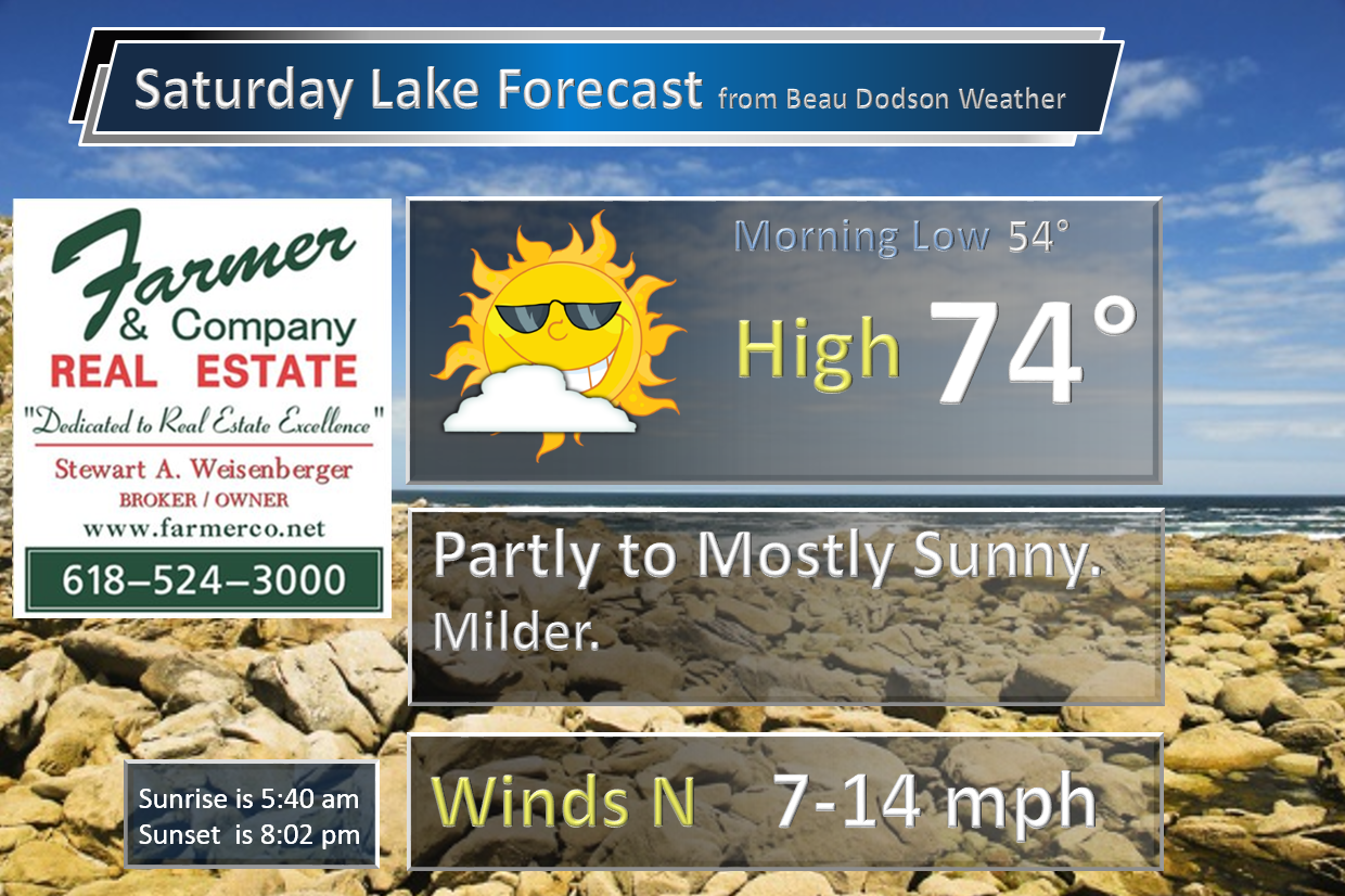
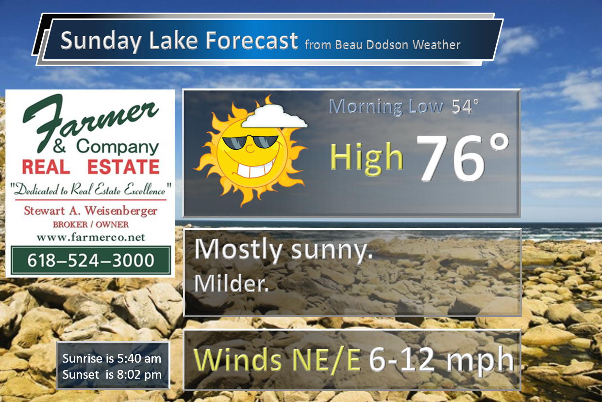
The weekend forecast is sponsored by Farmer and Company Real Estate. Click here to visit their site.


Don’t forget to check out the Southern Illinois Weather Observatory web-site for weather maps, tower cams, scanner feeds, radars, and much more! Click here

An explanation of what is happening in the atmosphere over the coming days…
- Video from Jacob Woods. The Mayfield, Kentucky Tornado.
- Calm weekend
- Warming trend!
- Unsettled next week with multiple chances for thunderstorms
My friend, Jacob Woods, put this video together. Jacob is an inspiring meteorologist. I think he will have a great career ahead of him.
Here is his video.
A look ahead to the weekend and beyond.
We had some rain showers on Friday, as expected. The greatest coverage was over our southern and southeastern counties. Northern and western counties did not experience much precipitation.
It appears we should have a dry weekend. There is a tiny chance for a shower on Saturday. Less than a ten percent chance. Both Saturday and Sunday will deliver mild temperatures. Highs into the 70s. It is possible someone could reach 80 degrees on Sunday. That will depend on cloud cover. The latest data indicates quite a bit of sun on both days. I hope you will be able to enjoy the weekend.
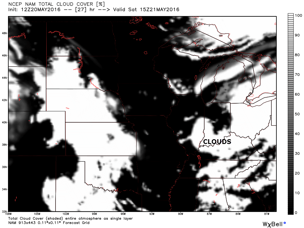
Future-cast satellite does show some cloud potential on Saturday morning over our northeastern counties. Perhaps parts of southeast Illinois and western Kentucky. Keep that in mind.
Here is the 9 am satellite view. Future-cast.
Monday appears dry, at this time. Warmer, as well.
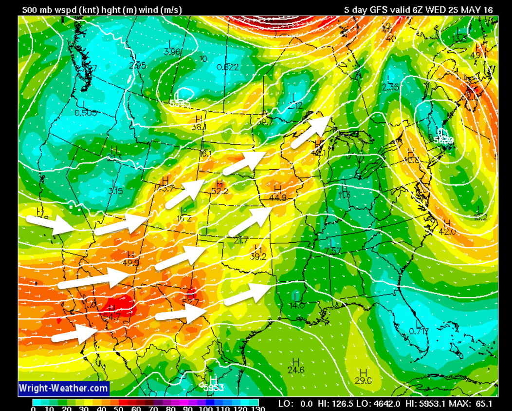
A southerly wind flow develops by Sunday into most of next week. Perhaps all of next week. Southerly flow means that the winds will be coming out of the south. This means higher dew points/more moisture in the atmosphere. Thus, thunderstorm chances will increase next week.
Here is the 500 mb jet stream map. This is many thousands of feet above the surface (where you live). You can see how the jet stream winds are out of the southwest. This is typically a signal for precipitation in our region. Increasing moisture. Disturbances moving through the region.
The colors on this wright-weather map represent wind speeds. The arrows represent wind direction. Click the map for a larger view.
It will be a bit tricky forecasting each small disturbance that will move through our region. There are signals that higher chances of thunderstorms will occur on Wednesday and Wednesday. Then again perhaps on Thursday night and Friday. But, we will have at least a chance for thunderstorms on radar from Tuesday right on into Memorial Day weekend. A bit early for specifics on Memorial Day weekend, but I did go ahead and include it in the day to day forecast.
You might notice in the long range (past day four) forecast that the probabilities for precipitation are low. Don’t let that fool you. I normally ramp up and not down. That means I will increase those numbers as we draw closer to the event. A 40% chance for precipitation four or five days out is actually a fairly high number.
The threat for severe weather won’t be zero next week. Still a bit early to know if we have any significant concerns. It is May. I would pay attention to updated forecasts.
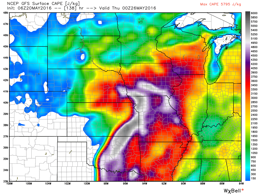
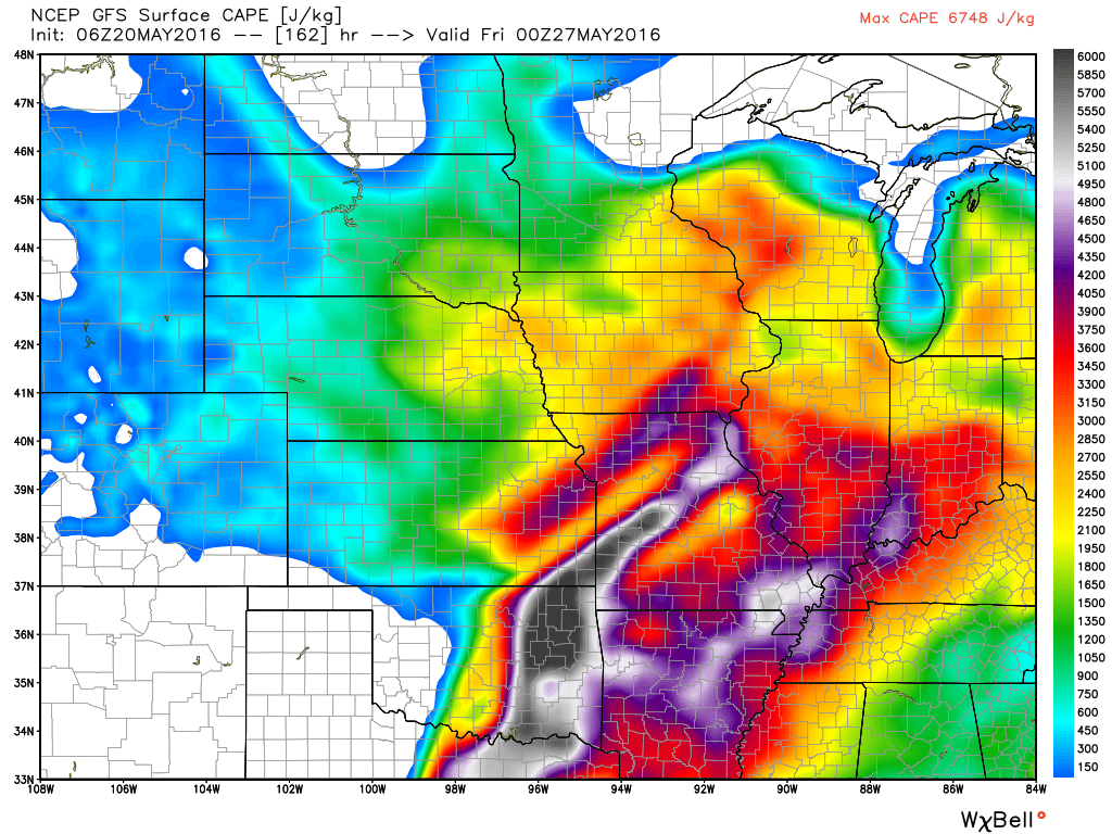
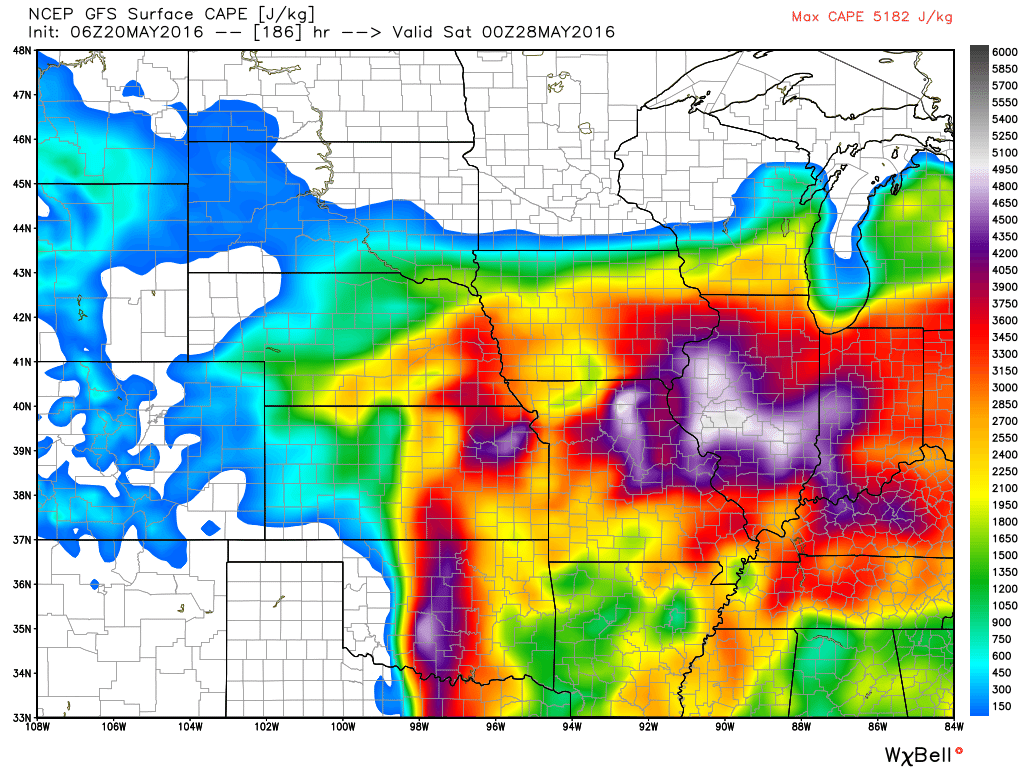
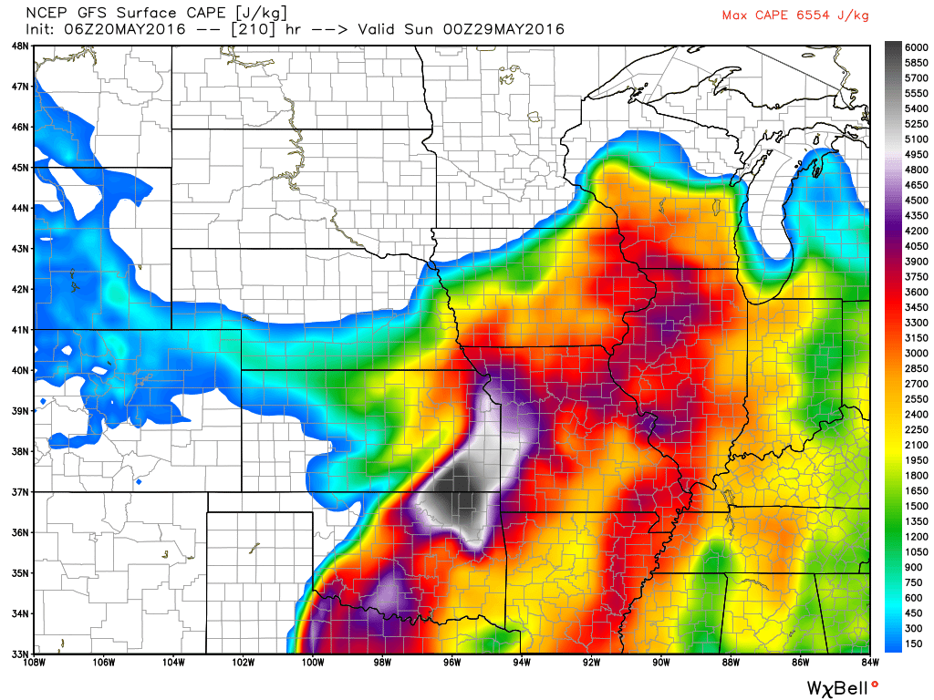
CAPE is a measure of energy in the atmosphere. Let me show you some CAPE maps. The colors represent where CAPE is available for thunderstorms to utilize. You can see that we have multiple days with CAPE.
This first map is for Tuesday afternoon.

Wednesday afternoon
Thursday afternoon
Friday afternoon
Saturday afternoon
Sunday afternoon
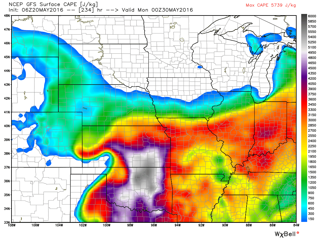
Basically the maps above (from weatherbell.com) mean that thunderstorms will be possible next week. And, some of the storms could be intense from time to time.
May has been quite cool, thus far!
Check out how cool May has been, thus far. These graphics are from Weatherbell.com. They show you the temperature anomalies. How many degrees above or below normal temperatures have been. Blue is below normal temperatures. You can see the scale on the right side of the page.
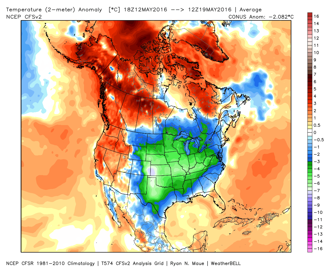
This next image is for the last 14 days
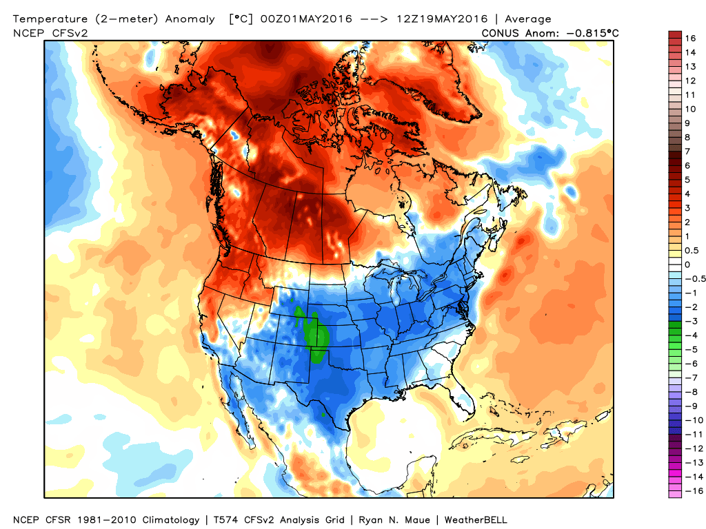
And, this last image is the month to date. Below normal has been the rule. But, you knew that already.
Let’s see how the rest of May plays out. We know it will be mild next week.
Radar


We have regional radars and local city radars – if a radar does not seem to be updating then try another one. Occasional browsers need their cache cleared. You may also try restarting your browser. That usually fixes the problem. Occasionally we do have a radar go down. That is why I have duplicates. Thus, if one fails then try another one.
If you have any problems then please send me an email beaudodson@usawx.com
WEATHER RADAR PAGE – Click here —
We also have a new national interactive radar – you can view that radar by clicking here.
Local interactive city radars include St Louis, Mt Vernon, Evansville, Poplar Bluff, Cape Girardeau, Marion, Paducah, Hopkinsville, Memphis, Nashville, Dyersburg, and all of eastern Kentucky – these are interactive radars. Local city radars – click here

Live Lightning Data – zoom and pan: Click here
Live Lightning Data with sound (click the sound button on the left side of the page): Click here

Can we expect severe thunderstorms over the next 24 to 48 hours? Remember that a severe thunderstorm is defined as a thunderstorm that produces 58 mph winds or higher, quarter size hail or larger, and/or a tornado.
.
Friday night: No severe weather.
Saturday: No severe weather
Saturday night into Sunday night: No severe weather
Monday: No severe weather
Tuesday: Monitor updates
Wednesday: Monitor updates
Thursday: Monitor updates
Friday: Monitor updates
.

.
No major changes on temperatures or wind speeds. No significant changes on precipitation chances. Next week will be a bit tricky on timing thunderstorm chances. Monitor updates.
.

.
No major concerns in this update.
.

.
No.
.

How much precipitation should we expect over the next few days?

.

Here are the current river stage forecasts. You can click your state and then the dot for your location. It will bring up the full forecast and hydrograph.
.
.

Here is the official 6-10 day and 8-14 day temperature and precipitation outlook. Check the date stamp at the top of each image (so you understand the time frame).
The forecast maps below are issued by the Weather Prediction Center (NOAA).


The latest 8-14 day temperature and precipitation outlook. Note the dates are at the top of the image. These maps DO NOT tell you how high or low temperatures or precipitation will be. They simply give you the probability as to whether temperatures or precipitation will be above or below normal.


Who do you trust for your weather information and who holds them accountable?
I have studied weather in our region since the late 1970’s. I have 37 years of experience in observing our regions weather patterns. My degree is in Broadcast Meteorology from Mississippi State University and an Associate of Science (AS). I am currently working on my Bachelor’s Degree in Geoscience.
My resume includes:
Member of the American Meteorological Society.
NOAA Weather-Ready Nation Ambassador.
Meteorologist for McCracken County Emergency Management. I served from 2005 through 2015.
I own and operate the Southern Illinois Weather Observatory.
Recipient of the Mark Trail Award, WPSD Six Who Make A Difference Award, Kentucky Colonel, and the Caesar J. Fiamma” Award from the American Red Cross.
In 2009 I was presented with the Kentucky Office of Highway Safety Award.
Recognized by the Kentucky House of Representatives for my service to the State of Kentucky leading up to several winter storms and severe weather outbreaks.
I am also President of the Shadow Angel Foundation which serves portions of western Kentucky and southern Illinois.
There is a lot of noise on the internet. A lot of weather maps are posted without explanation. Over time you should learn who to trust for your weather information.
My forecast philosophy is simple and straight forward.
- Communicate in simple terms
- To be as accurate as possible within a reasonable time frame before an event
- Interact with you on Twitter, Facebook, and the blog
- Minimize the “hype” that you might see on television or through other weather sources
- Push you towards utilizing wall-to-wall LOCAL TV coverage during severe weather events
I am a recipient of the Mark Trail Award, WPSD Six Who Make A Difference Award, Kentucky Colonel, and the Caesar J. Fiamma” Award from the American Red Cross. In 2009 I was presented with the Kentucky Office of Highway Safety Award. I was recognized by the Kentucky House of Representatives for my service to the State of Kentucky leading up to several winter storms and severe weather outbreaks.
If you click on the image below you can read the Kentucky House of Representatives Resolution.

Many of my graphics are from www.weatherbell.com – a great resource for weather data, model data, and more


You can sign up for my AWARE email by clicking here I typically send out AWARE emails before severe weather, winter storms, or other active weather situations. I do not email watches or warnings. The emails are a basic “heads up” concerning incoming weather conditions.