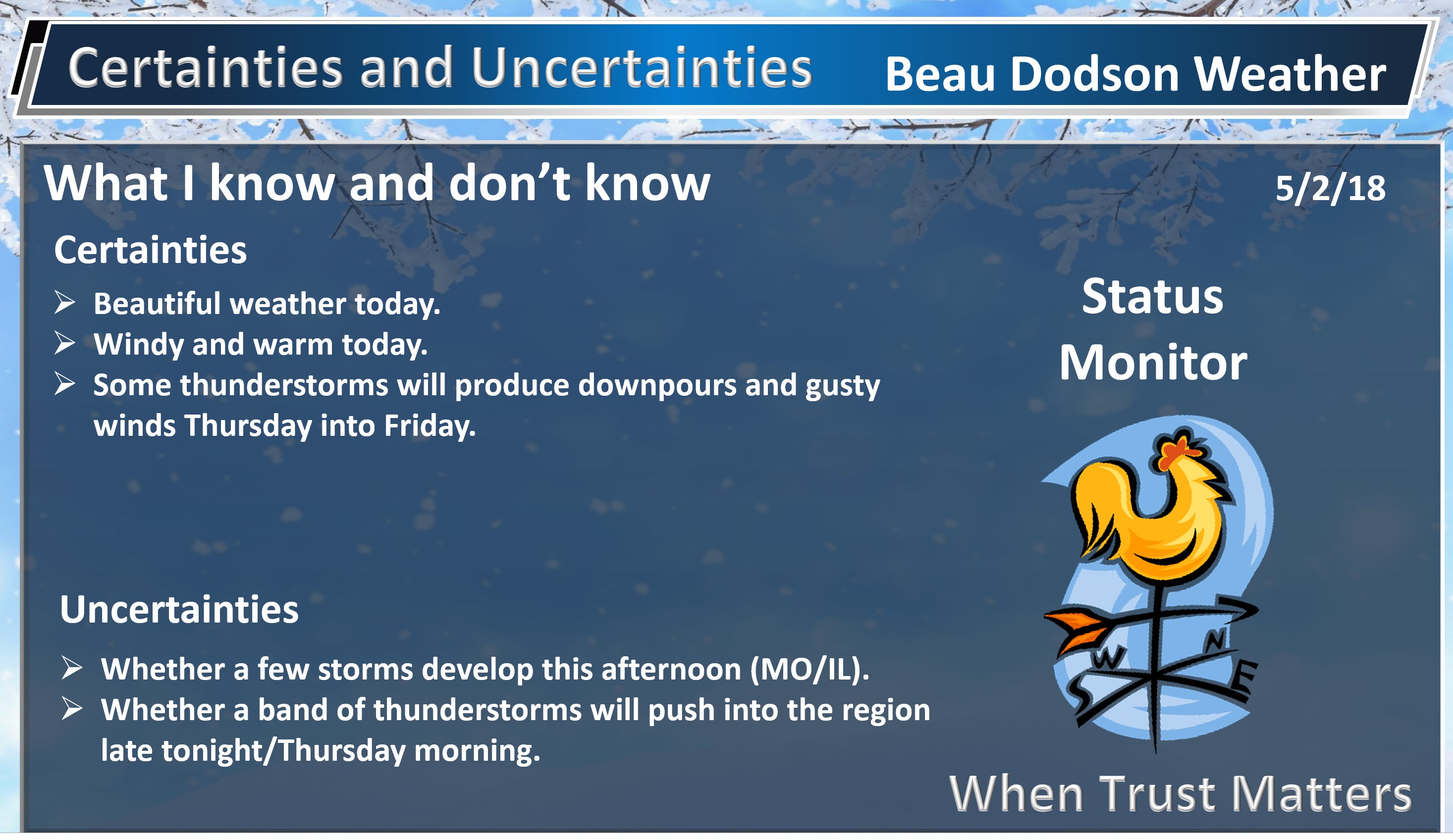
Afternoon Update
There remain questions about the risk of thunderstorms tonight/early morning. This is especially true for southeast Missouri and southwest Illinois. A line of thunderstorms is forecast to form from Iowa into Missouri later today.
This line of thunderstorms will push eastward overnight. It will be weakening as it pushes further and further east.
Not all the guidance shows this complex of thunderstorms. That raises questions about the eventual outcome of the forecast.
I have increased rain chances across southeast Missouri and southwest Illinois. I increased them slightly elsewhere.
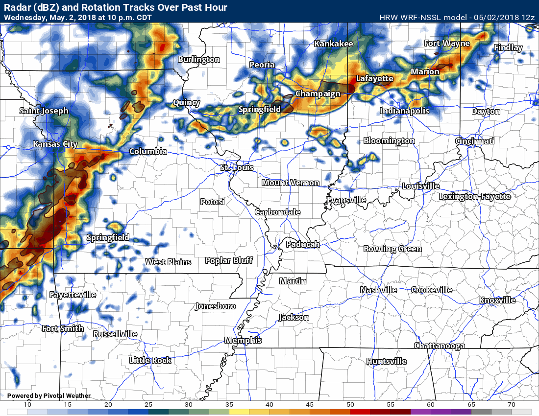
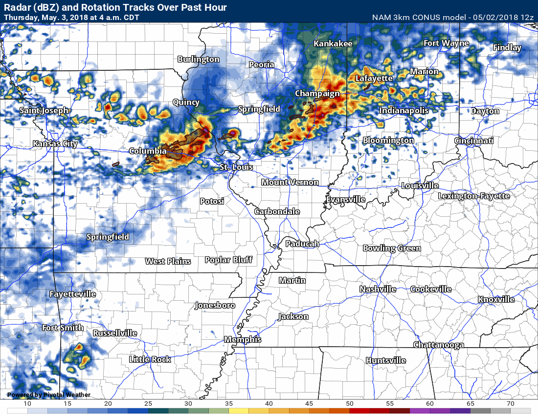
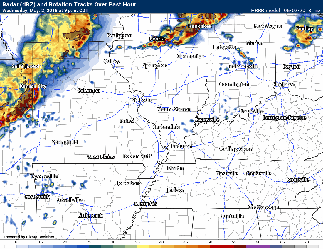
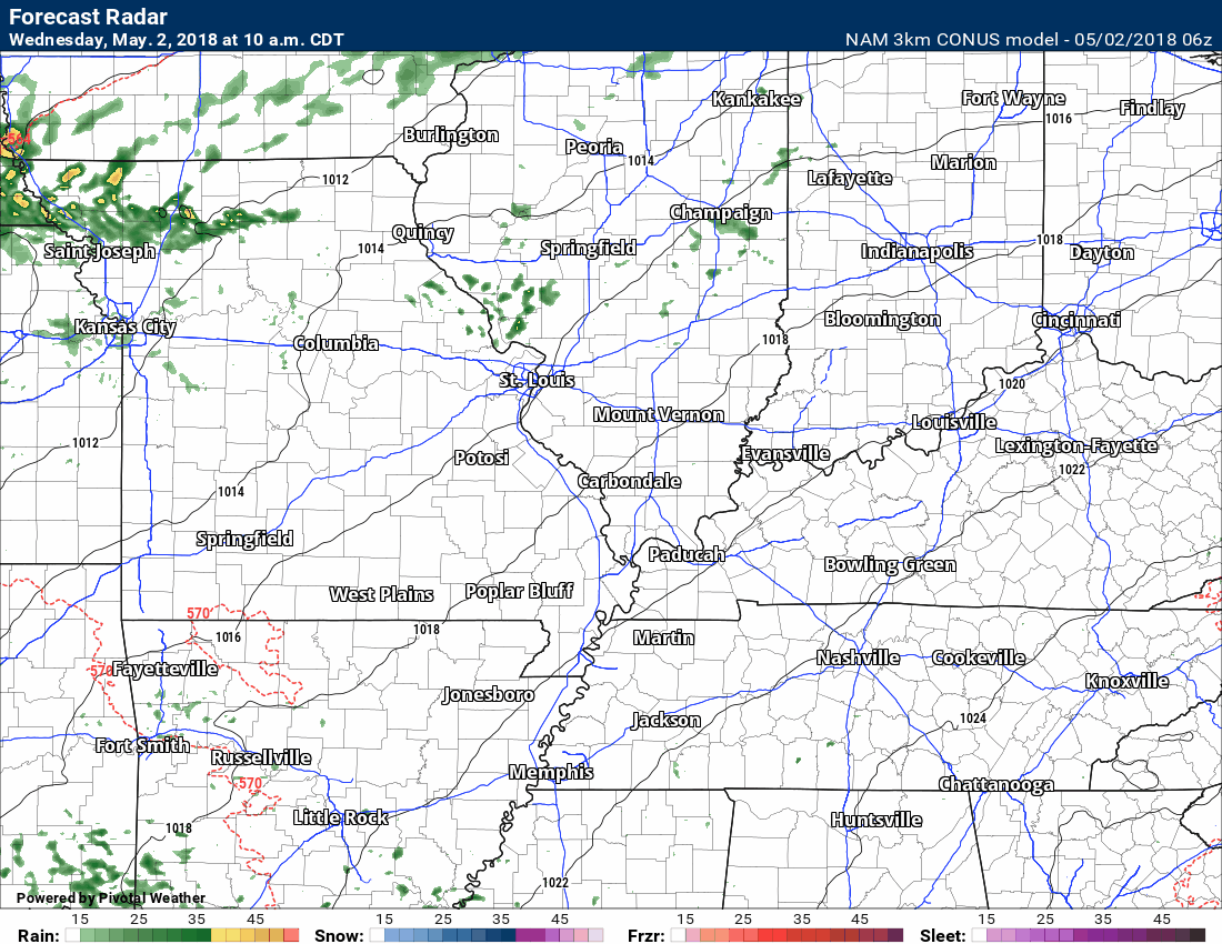
Here are what some of the models are showing. These are future-cast radars. Models are never perfect. That is why they don’t agree.
I do believe we will see a line of thunderstorms push into southeast Missouri and southwest Illinois late tonight. It will be weakening. As it moves further and further east it could dissipate altogether.
Here is the SPC WRF model
The timestamp is located in the upper left.
Notice the timestamps on these model runs extend out to different times.
Here is the NAM 3K model
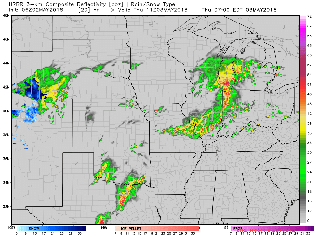
Here is the Hrrr model guidance (this one goes out to 4 AM)
WeatherTalk monthly operating costs can top $2000.00. Your $3 subscription helps pay for those costs. I work for you.
For $3 a month you can receive the following. You may choose to receive these via your WeatherTalk app or regular text messaging.
- Severe weather app/text alerts from my keyboard to your app/cell phone. These are hand typed by Beau. During tornado outbreaks, you will receive numerous app/text messages telling you exactly where the tornado is located.
- Daily forecast app/texts from my computer to your app/cell phone.
- Social media links sent directly to your app/cell phone. When I update the blog, videos, or Facebook you will receive the link.
- AWARE emails. These emails keep you well ahead of the storm. They give you several days of lead time before significant weather events.
- Direct access to Beau via text and email. Your very own personal meteorologist. I work for you!
- Missouri and Ohio Valley centered video updates
- Long-range weather videos
- Week one, two, three and four temperature and precipitation outlooks.
- Monthly outlooks.
- Your subscription also will help support several local charities.
Haven’t you subscribed? Subscribe at www.beaudodsonweather.com

Example of a recent severe weather alert. I issued this well before the official tornado warning. You would have had plenty of time for you and your family to seek shelter.


Your $3 per month also helps support these local charity projects.

I encourage subscribers to use the app vs regular text messaging. We have found text messaging to be delayed during severe weather. The app typically will receive the messages instantly. I recommend people have three to four methods of receiving their severe weather information.
Remember, my app and text alerts are hand typed and not computer generated. You are being given personal attention during significant weather events.

WWW.WEATHERTALK.COM subscribers, here is my day to day schedule for your weather products.


May 2, 2018
Wednesday Forecast Details
Forecast: Partly sunny. Windy. Quite warm. An isolated thunderstorm possible.
Temperatures: MO ~ 80 to 85 IL ~ 80 to 85 KY ~ 80 to 85 TN ~ 80 to 85
What is the chance of precipitation? MO ~ 20% IL ~ 20% KY ~ 10% TN ~ 10%
Coverage of precipitation: None to isolated
Winds: South and southwest wind 12 to 25 mph and gusty.
What impacts are anticipated from the weather? Odds favor it remaining dry. Isolated wet roads and lightning.
My confidence in the forecast verifying: High
Is severe weather expected? Unlikely
The NWS defines severe weather as 58 mph wind or great, 1″ hail or larger, and/or tornadoes
Should I cancel my outdoor plans? No, but check updates and radars
Sunrise: 5:58 AM
Wednesday Night Forecast Details:
Forecast: Increasingly cloudy sky conditions. Showers and thunderstorms pushing into southeast Missouri and southern Illinois late tonight into the wee early morning hours. There is low confidence about just how far east these thunderstorms will survive. They will be weakening. Storms in southeast Missouri and southwest Illinois could still produce some reports of strong and gusty winds. Small hail, as well. Lightning, of course. As you move further east the chances of rain will be less and less.
Temperatures: MO ~ 68 to 72 IL ~ 66 to 70 KY ~ 66 to 70 TN ~ 68 to 72
What is the chance of precipitation? MO ~ 60% (mostly late) IL ~ (mostly late also) 60% for southwest Illinois and 30% for southeast Illinois KY ~ 30% TN ~ 20%
Coverage of precipitation: There is a chance for a line of showers and thunderstorms pushing into southeast Missouri and southwest Illinois late tonight. If that occurs then numerous showers and thunderstorms would be the end result. There remain questions about how far east this line of storms will maintain intensity. It should be weakening as it moves further and further east.
Winds: South and southwest at 8 to 16 mph and gusty
What impacts are anticipated from the weather? Scattered wet roadways and lightning. Gusty winds near storms in southeast Missouri and southwest Illinois.
My confidence in the forecast verifying: Medium
Is severe weather expected? A few storms could be intense or near severe levels across southeast Missouri and southwest Illinois.
The NWS defines severe weather as 58 mph wind or great, 1″ hail or larger, and/or tornadoes
Should I cancel my outdoor plans? No, but monitor radars
Sunset: 7:44 PM
May 3, 2018
Thursday Forecast Details
Forecast: Mostly cloudy. Showers and thunderstorms. A few storms could produce heavy rain and gusty winds. A low end risk of hail. Small risk of severe weather. Damaging wind would be the primary concern.
Temperatures: MO ~ 80 to 84 IL ~ 80 to 83 KY ~ 80 to 84 TN ~ 80 to 84
What is the chance of precipitation? MO ~ 70% IL ~ 60% KY ~ 60% TN ~ 60%
Coverage of precipitation: Scattered to perhaps numerous.
Winds: South at 10 to 20 mph and gusty
What impacts are anticipated from the weather? Wet roadways. Lightning. A strong thunderstorm possible with gusty winds and small hail.
My confidence in the forecast verifying: Medium
Is severe weather expected? Monitor updates. A few strong storms possible.
The NWS defines severe weather as 58 mph wind or great, 1″ hail or larger, and/or tornadoes
Should I cancel my outdoor plans? No, but monitor updated forecasts and radars
Sunrise: 5:57 AM
Thursday Night Forecast Details:
Forecast: Mostly cloudy. A chance of showers and thunderstorms. Mild and breezy.
Temperatures: MO ~ 63 to 66 IL ~62 to 65 KY ~ 64 to 66 TN ~ 64 to 68
What is the chance of precipitation? MO ~ 60% IL ~ 60% KY ~ 60% TN ~ 60%
Coverage of precipitation: Scattered to perhaps numerous
Winds: South and southwest at 10 to 20 mph
What impacts are anticipated from the weather? Wet roadways. Lightning. A few storms could produce heavy rain and gusty winds.
My confidence in the forecast verifying: Medium
Is severe weather expected? Some storms could be strong. The overall severe weather risk is limited. Monitor updates, as always.
The NWS defines severe weather as 58 mph wind or great, 1″ hail or larger, and/or tornadoes
Should I cancel my outdoor plans? Monitor updates.
Sunset: 7:45 PM
May 4, 2018
Friday Forecast Details
Forecast: Partly cloudy. Showers and thunderstorms again possible. Warm and breezy. A few strong thunderstorms.
Temperatures: MO ~ 76 to 82 IL ~ 76 to 82 KY ~ 76 to 82 TN ~ 78 to 84
What is the chance of precipitation? MO ~ 50% IL ~ 50% KY ~ 60% TN ~ 60%
Coverage of precipitation: Scattered to perhaps numerous
Winds: Southwest at 10 to 15 mph with gusts to 25 mph. Gusty.
What impacts are anticipated from the weather? Wet roadways. Lightning. Perhaps locally heavy downpours.
My confidence in the forecast verifying: Medium
Is severe weather expected? Monitor updates
The NWS defines severe weather as 58 mph wind or great, 1″ hail or larger, and/or tornadoes
Should I cancel my outdoor plans? Monitor updates
Sunrise: 5:56 AM
Friday Night Forecast Details:
Forecast: Partly to mostly cloudy. Scattered showers or thunderstorms possible. Evening storms could be strong.
Temperatures: MO ~ 55 to 60 IL ~ 55 to 60 KY ~ 55 to 60 TN ~ 55 to 60
What is the chance of precipitation? MO ~ 30% IL ~ 30% KY ~ 40% TN ~ 40%
Coverage of precipitation: Scattered.
Winds: West and northwest wind at 5 to 10 mph with gusts to 14 mph
What impacts are anticipated from the weather? Wet roadways and lightning.
My confidence in the forecast verifying: LOW
Is severe weather expected? Monitor
The NWS defines severe weather as 58 mph wind or great, 1″ hail or larger, and/or tornadoes
Should I cancel my outdoor plans? No, but monitor updates. Some areas may still experience precipitation into Friday night.
Sunset: 7:46 PM
May 5, 2018
Saturday Forecast Details
Forecast: Partly to mostly sunny. An isolated shower or thunderstorm may remain in the region. Isolated to perhaps scattered. Greatest coverage over the Missouri Bootheel and then along the Kentucky and Tennessee border. Lesser chances further north.
Temperatures: MO ~ 75 to 80 IL ~ 75 to 80 KY ~ 75 to 80 TN ~ 75 to 80
What is the chance of precipitation? MO ~ 20% IL ~ 20% KY ~ 30% TN ~ 30%
Coverage of precipitation: Isolated to perhaps scattered. Greatest coverage over the Missouri Bootheel and then along the Kentucky and Tennessee border. Lesser chances further north.
Winds: West and northwest at 5 to 10 mph with gusts to 14 mph
What impacts are anticipated from the weather? Scattered wet roadways and lightning.
My confidence in the forecast verifying: Medium
Is severe weather expected? No
The NWS defines severe weather as 58 mph wind or great, 1″ hail or larger, and/or tornadoes
Should I cancel my outdoor plans? No
Sunrise: 5:55 AM
Saturday Night Forecast Details:
Forecast: Mostly clear and cool.
Temperatures: MO ~ 53 to 56 IL ~ 53 to 56 KY ~ 53 to 56 TN ~ 53 to 56
What is the chance of precipitation? MO ~ 0% IL ~ 0% KY ~ 10% TN ~ 10%
Coverage of precipitation: None
Winds: Light and variable
What impacts are anticipated from the weather? None
My confidence in the forecast verifying: Medium
Is severe weather expected? No
The NWS defines severe weather as 58 mph wind or great, 1″ hail or larger, and/or tornadoes
Should I cancel my outdoor plans? No
Sunset: 7:47 PM
May 6, 2018
Sunday Forecast Details
Forecast: Partly to mostly sunny. A chance of a shower or thunderstorm over the northern parts of southeast Missouri and northern parts of southern Illinois.
Temperatures: MO ~ 76 to 82 IL ~ 76 to 82 KY ~ 76 to 82 TN ~ 76 to 82
What is the chance of precipitation? MO ~ 20% IL ~ 20% KY ~ 10% TN ~ 10%
Coverage of precipitation: Isolated
Winds: West wind 5 to 10 mph
What impacts are anticipated from the weather? Wet roadways. Lightning. (northern counties).
My confidence in the forecast verifying: Medium
Is severe weather expected? No
The NWS defines severe weather as 58 mph wind or great, 1″ hail or larger, and/or tornadoes
Should I cancel my outdoor plans? No
Sunrise: 5:54 AM
Sunday Night Forecast Details:
Forecast: Partly cloudy. A shower or thunderstorm possible. Low confidence in rain chances.
Temperatures: MO ~ 54 to 58 IL ~ 53 to 56 KY ~ 53 to 56 TN ~ 53 to 56
What is the chance of precipitation? MO ~ 20% IL ~ 20% KY ~ 20% TN ~ 20%
Coverage of precipitation: Scattered
Winds: North at 5 to 10 mph
What impacts are anticipated from the weather? Wet roadways. Lightning.
My confidence in the forecast verifying: LOW
Is severe weather expected? No
The NWS defines severe weather as 58 mph wind or great, 1″ hail or larger, and/or tornadoes
Should I cancel my outdoor plans? No
Sunset: 7:48 PM
May 7, 2018
Monday Forecast Details
Forecast: Mostly sunny. A few clouds. Warm. A slight chance of a shower.
Temperatures: MO ~ 74 to 76 IL ~ 74 to 76 KY ~ 74 to 76 TN ~ 74 to 76
What is the chance of precipitation? MO ~ 10% IL ~ 10% KY ~ 10% TN ~ 10%
Coverage of precipitation: None to isolated
Winds: North and northeast at 5 to 10 mph
What impacts are anticipated from the weather? None to perhaps an isolated wet roadway
My confidence in the forecast verifying: Medium
Is severe weather expected? No
The NWS defines severe weather as 58 mph wind or great, 1″ hail or larger, and/or tornadoes
Should I cancel my outdoor plans? No
Sunrise: 5:53 AM
Monday Night Forecast Details:
Forecast: A few clouds. Cool.
Temperatures: MO ~ 50 to 55 IL ~ 50 to 55 KY ~ 50 to 55 TN ~ 50 to 55
What is the chance of precipitation? MO ~ 0% IL ~ 0% KY ~ 0% TN ~ 0%
Coverage of precipitation: None
Winds: Northeast and east at 5 to 10 mph
What impacts are anticipated from the weather? None
My confidence in the forecast verifying: Medium
Is severe weather expected? No
The NWS defines severe weather as 58 mph wind or great, 1″ hail or larger, and/or tornadoes
Should I cancel my outdoor plans? No
Sunset: 7:48 PM
May 8, 2018
Tuesday Forecast Details
Forecast: Mostly sunny.
Temperatures: MO ~ 74 to 78 IL ~ 74 to 78 KY ~ 74 to 78 TN ~ 74 to 78
What is the chance of precipitation? MO ~ 0% IL ~ 0% KY ~ 0% TN ~ 0%
Coverage of precipitation: Most likely none
Winds: Northeast at 6 to 12 mph
What impacts are anticipated from the weather? Most likely none
My confidence in the forecast verifying: Medium
Is severe weather expected? No
The NWS defines severe weather as 58 mph wind or great, 1″ hail or larger, and/or tornadoes
Should I cancel my outdoor plans? No
Sunrise: 5:52 AM
Tuesday Night Forecast Details:
Forecast: Partly cloudy.
Temperatures: MO ~ 55 to 60 IL ~ 55 to 60 KY ~ 55 to 60 TN ~ 55 to 60
What is the chance of precipitation? MO ~ 9% IL ~ 0% KY ~ 0% TN ~ 0%
Coverage of precipitation: Most likely none
Winds: East and southeast at 5 to 10 mph
What impacts are anticipated from the weather? Most likely none
My confidence in the forecast verifying: Medium
Is severe weather expected? No
The NWS defines severe weather as 58 mph wind or great, 1″ hail or larger, and/or tornadoes
Should I cancel my outdoor plans? No
Sunset: 7:49 PM
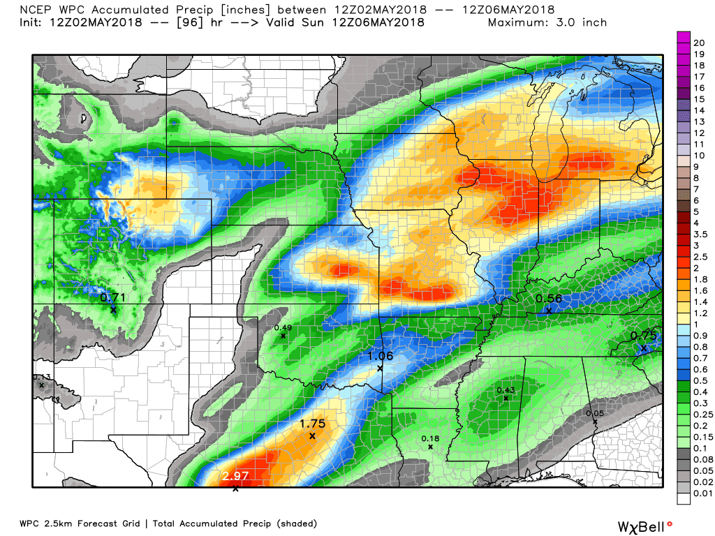
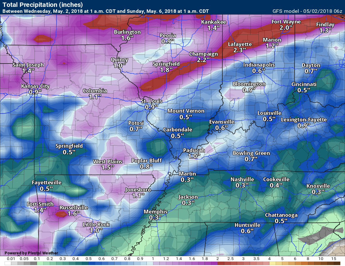
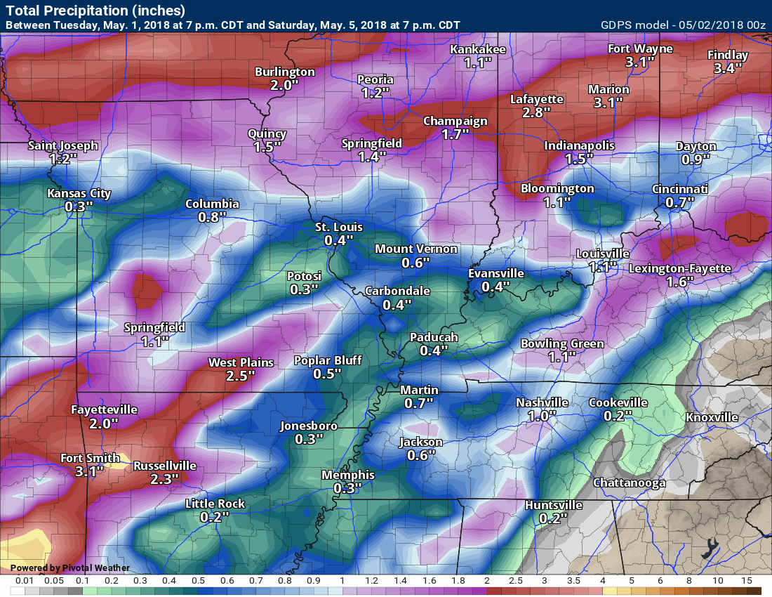
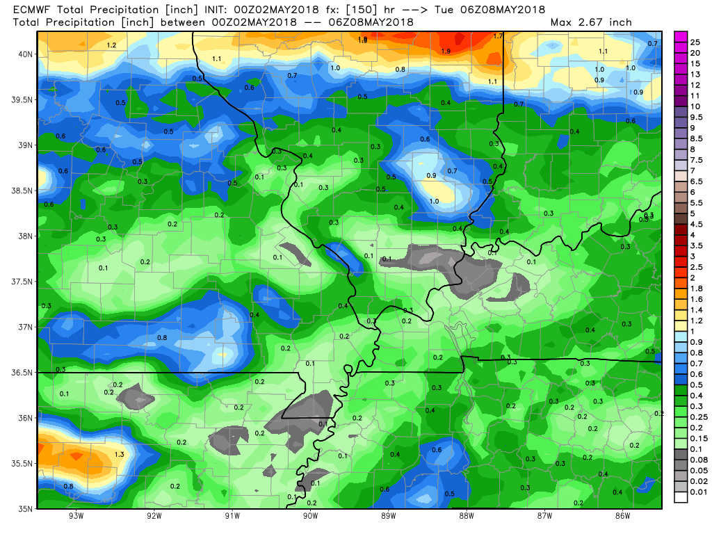
RAIN TOTALS
Models vary in totals. This is partly due to convection/thunderstorms. Thunderstorms can double or even triple what everyone else receives. It is that time of the year. Keep this in mind.
These four graphics show you what the WPC and three models are forecasting.
It would not surprise me if some areas receive very little in the way of rainfall. Others could exceed an inch of rain.
Click images to enlarge.
WPC/NOAA seven day rain forecast
GFS model guidance seven-day rain forecast
Canadian model guidance seven-day rain forecast
EC model guidance

Interactive Radars:
Interactive live weather radar page. Choose the city nearest your location. If one of the city radars won’t load then try a nearby one. Click here.

Questions? Broken links? Other?
You may email me at beaudodson@usawx.com

The National Weather Service defines a severe thunderstorm as one that produces quarter size hail or larger, 58 mph winds or greater, and/or a tornado.
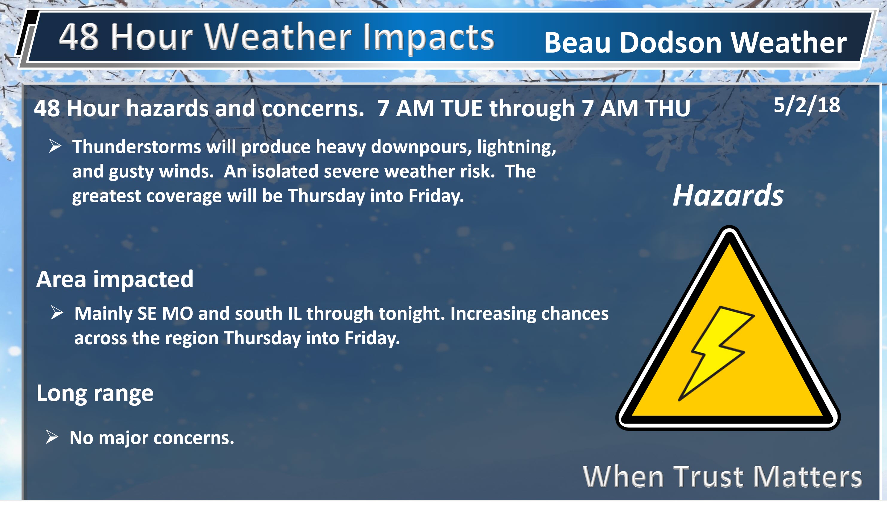
Wednesday and Wednesday night: Mostly dry. There is a slight chance of a thunderstorm across mainly southeast Missouri and southern Illinois.
Thursday through Friday night: Thunderstorms are likely to occur Thursday into Friday. A few of the storms could be intense. Monitor updates. The main concern will be isolated damaging winds. The overall severe weather risk is rather low.
The system will be weakening as it moves into our region Thursday and Friday. The greatest severe weather risk will occur today and tonight to our west.
Saturday and Sunday: Severe weather is not anticipated. Isolated reports of lightning.
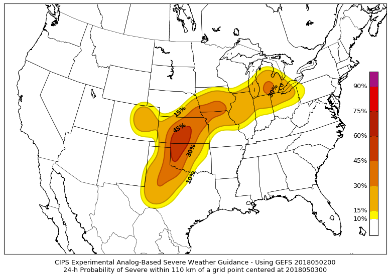
Analog forecasts are showing some signals for thunderstorms in the Central United States over the coming days.
What are analogs?
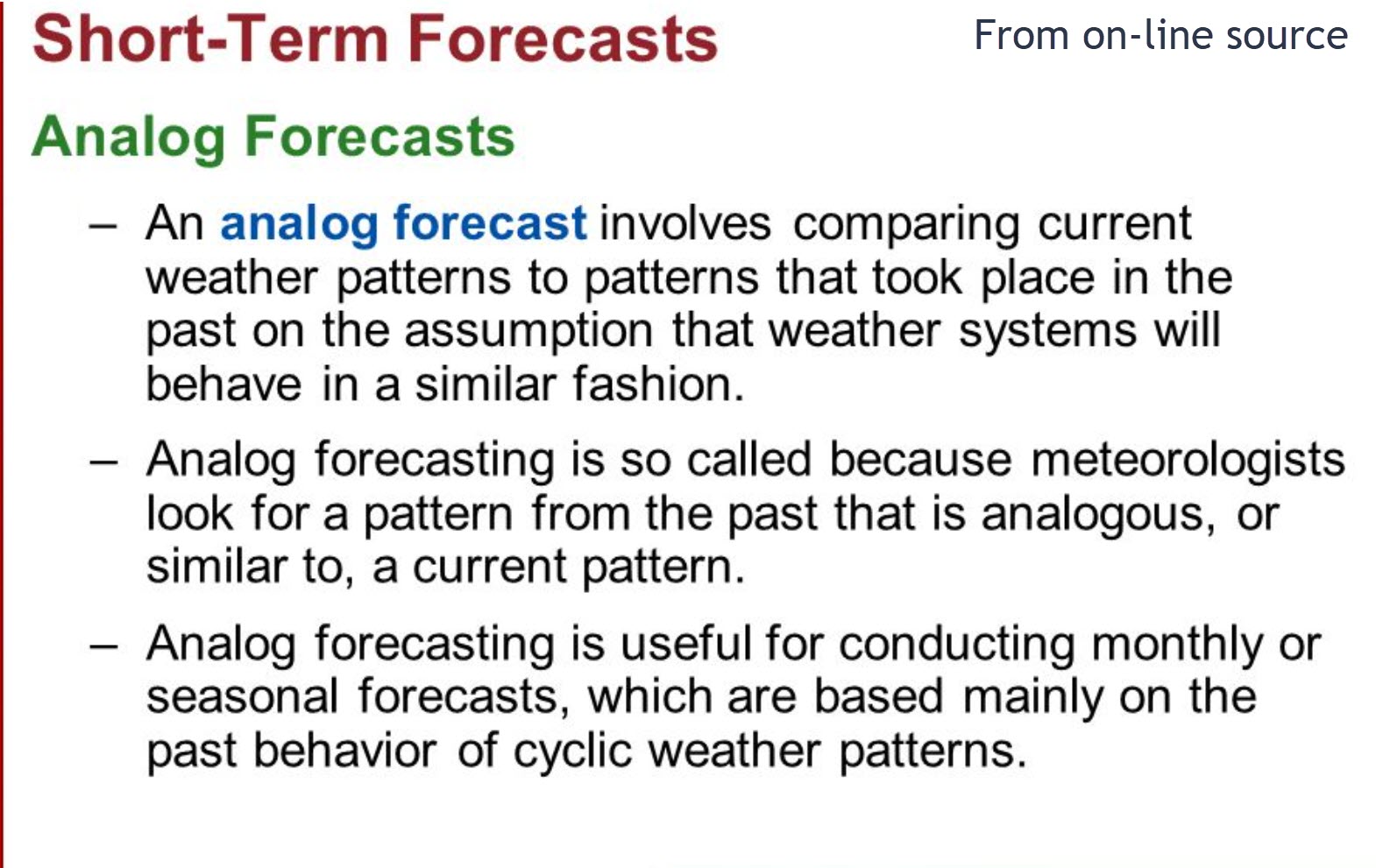
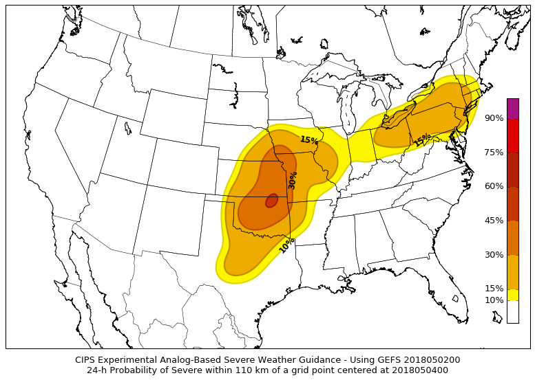
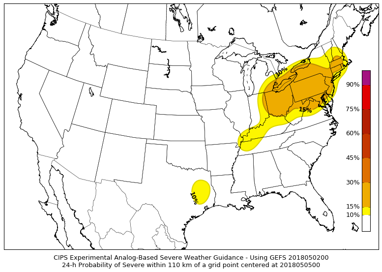
Here are the analog maps. The colors basically mean thunderstorms are possible and some storms could be intense. The darker the color shading the greater the risk. The largest risk is too our west. Whether this shifts eastward will need to be monitored.
This is today. The greatest risk will be across Texas, Oklahoma, and Kansas and then northeast from there.
This is the Thursday map.
This last one is the Friday map. A low risk on Friday for intense thunderstorms. We will need to monitor Friday. Some of the guidance indicates higher CAPE numbers. CAPE is energy for thunderstorms.
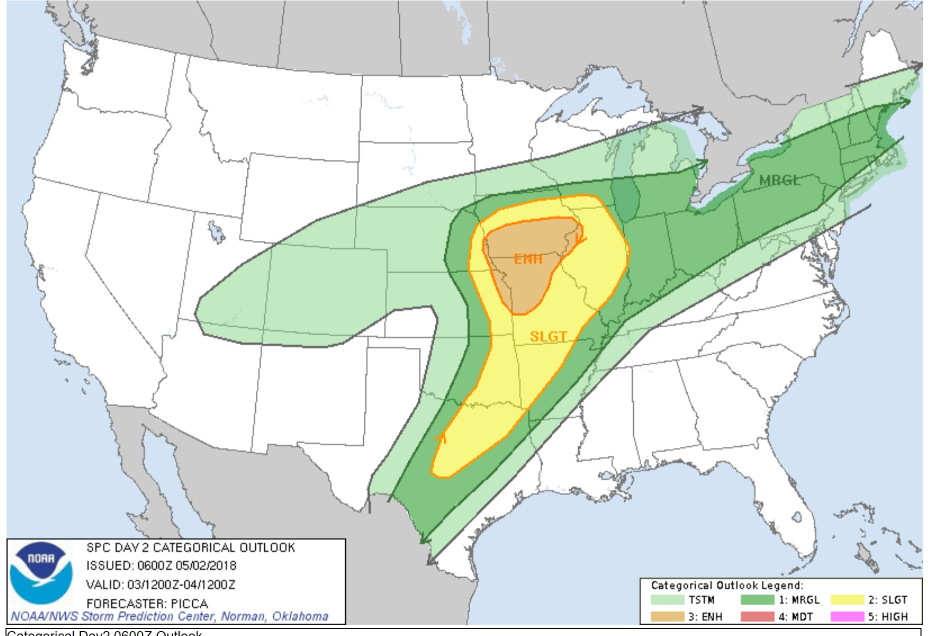
The Storm Prediction Center has outlined an area to our west today. Our region is in and near a risk Thursday.
The light green zone is where sub-severe storms are possible.
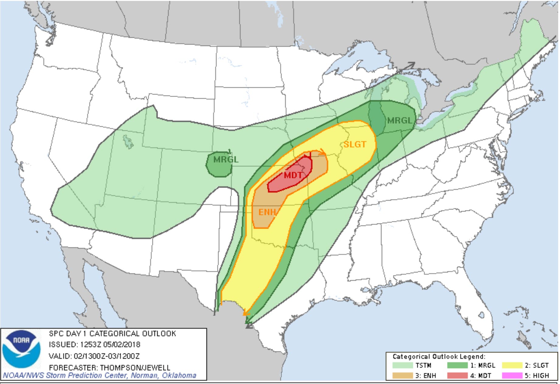
Here is the Thursday outlook. This is the Storm Prediction Center’s outlook. We are in a marginal (lowest level risk) risk Thursday and Thursday night. This is a level one out of five risk. One is the lowest and five is the highest. The slight risk (level 2 in yellow) attempts to brush our region.
Bottom line, a few intense thunderstorms will be possible Thursday into Friday. The risk of severe weather is rather low and should not be widespread.
Again, the light green is where sub-severe thunderstorms are possible.
![]()
Interactive live weather radar page. Choose the city nearest your location. If one of the cities does not work then try a nearby one. Click here.
National map of weather watches and warnings. Click here.
Storm Prediction Center. Click here.
Weather Prediction Center. Click here.

Live lightning data: Click here.

Interactive GOES R satellite. Track clouds. Click here.

Here are the latest local river stage forecast numbers Click Here.
Here are the latest lake stage forecast numbers for Kentucky Lake and Lake Barkley Click Here.

The spring and preliminary summer outlooks have been posted for subscribers. Scroll down to see the outlook.
Not a subscriber? Learn more at this link.

Weather Headlines
- Warm and windy today through Friday
- Thunderstorm chances will be on the increase
- Saturday and Sunday should be mostly dry, but I did have to introduce a low-end chance of storms
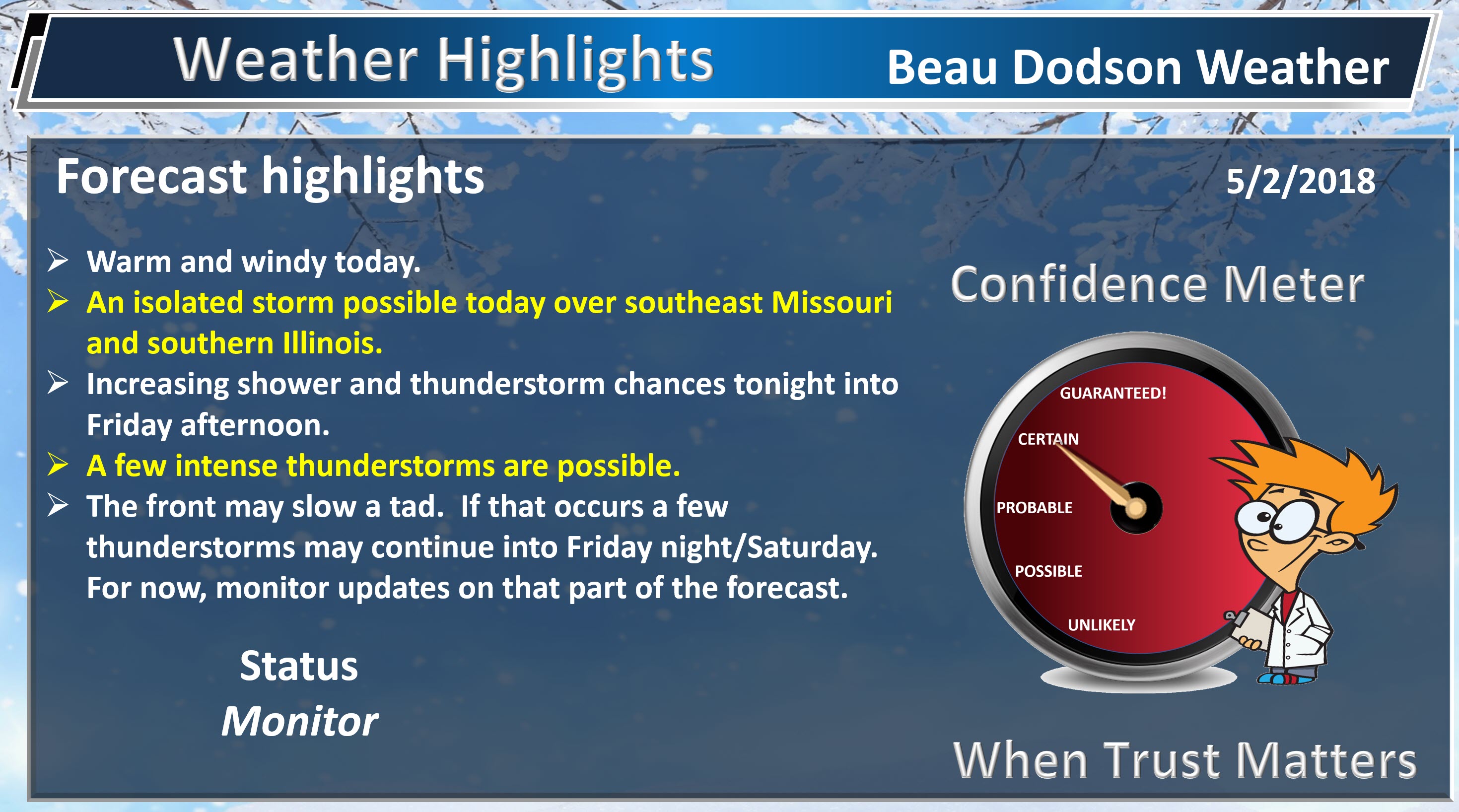
Wow, it is warm! We continue the warm theme into the rest of the week. Great news for those waiting on spring to arrive. I know many want to plant some seeds in the ground.
Plan on highs in the 80’s today into Friday. The warmest week since last fall.
Winds today will gust above 30 mph. Use care if boating.
A cold front is situated well to our west today. This front will spark severe thunderstorms and even tornadoes across portions of the Central United States. Thankfully, that will remain to our west.
We may have an isolated thunderstorm develop today. The greatest risk would be across southeast Missouri and southern Illinois. Even there, the risk is rather low.
More of the same tonight. Breezy conditions and mild overnight lows. An isolated thunderstorm possible.
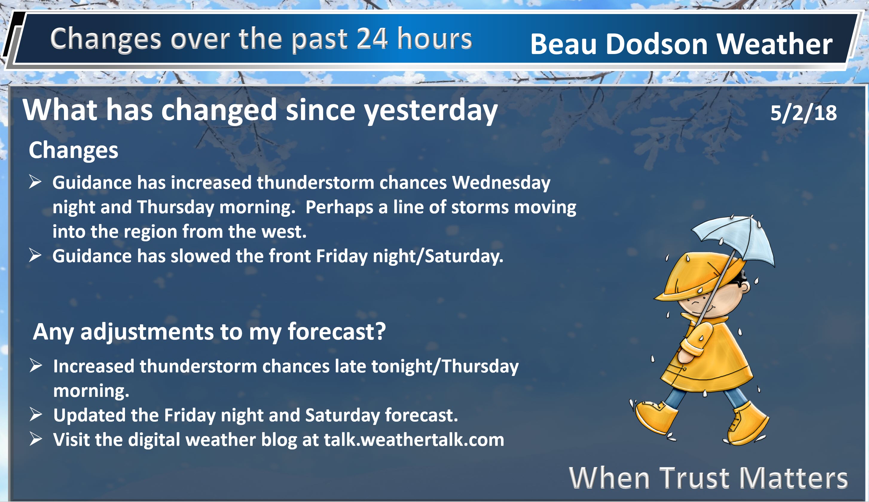
Thunderstorm chances will begin to rise Thursday into Friday. This will occur as the frontal boundary slowly move east and southeast.
A few of the storms could produce locally heavy downpours, small hail, and gusty winds. There is a marginal risk that a couple of thunderstorms could become severe. The main concern would be damaging winds. Overall, the risk is low at any given location. As always, monitor updates.
Rainfall totals will vary considerably. Most areas will pick up 0.10″ to 0.50″. Thunderstorms can easily double or triple those amounts. Keep that in mind. It is that time of the year. Thunderstorms produce locally heavy rain. One county can pick up an inch of rain and neighboring areas receive very little.
It would not surprise me if a few locations receive little in the way of rainfall. Model guidance has struggled with this topic.
At one time this looked to be a widespread heavy rain event with PWAT (moisture levels) spiking for several days. Over the last few days, it became apparent that that would not be the case. Instead of widespread heavy rain, it would be more scattered.
I am monitoring Friday nights rain probability numbers. It is possible that the front slows. If the front slows then rain chances will extend into the overnight hours.
There is major disagreement in the models concerning a band of thunderstorms late tonight into Thursday morning. See graphics below.
Here is the NAM 3K model guidance future-cast radar. This shows you what radar MIGHT look like over the next 48 hours. The timestamp is located in the upper left portion of the graphic.
The Hrrrx model guidance shows a band of thunderstorms moving into our region Thursday morning. This will need to be monitored.
This is the Hrrrx model guidance. This is 6 AM Thursday. You can see a band of storms moving through our region (esp MO/IL).
This is another model. High-resolution model. Notice how it develops a line of storms to our west Wednesday night and then pushes it into our region Thursday morning.
We will need to keep an eye on this. It will be weakening.
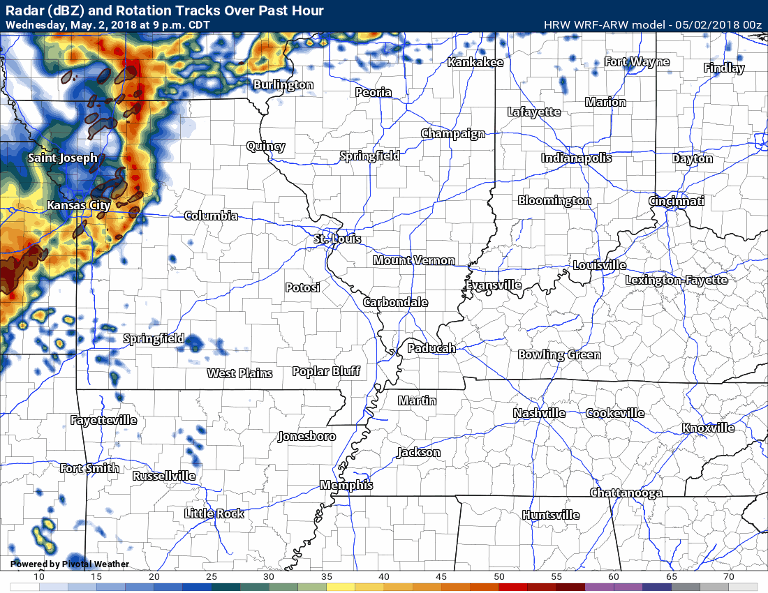
Different models. Different opinions.
The morning thunderstorm complex idea does have support from several guidance packages.
Weekend:
For the most part, Saturday and Sunday will remain dry. I did introduce a slight chance of thunderstorms Saturday. That would mainly be across Kentucky and Tennessee. Hopefully, the front will continue to push southward. This southward push would end our rain chances. Confidence in storms Saturday is low.
I would not cancel any weekend plans (Saturday or Sunday). I would monitor updates and radars if you have concerns.
Shower and thunderstorm chances should begin to increase a bit on Sunday night/Monday. Some of the guidance attempts to develop a complex of thunderstorms to our north and northwest. It tracks it southeast. This will need to be monitored, as well.

Weather Brains is a weekly podcast/video for those who love weather and want more!
Weather Brains episode number 640
Tonight’s WeatherBrain is the Emergency Response Meteorologist for the National Weather Service Southern Region Headquarters, Jennifer McNatt. Also joining us is Elinor Lutu-McMoore, the Meteorologist in Charge at the NWS office in Pago Pago, American Samoa.
Other discussions in this weekly podcast include topics like:
- Extremes: 103 at Thermal, CA, & Death Valley, CA, and 15 at Estcourt Station, ME
- Kevin checks out phased-array radar prototype
- Discussion on issue of differing graphics from different weather agencies
- Gulf coast tornadoes on 4/22
- Astronomy Outlook with Tony Rice
- and more!
Previous episodes can be viewed by clicking here.

We offer interactive local city live radars and regional radars. If a radar does not update then try another one. If a radar does not appear to be refreshing then hit Ctrl F5. You may also try restarting your browser.
The local city view radars also have clickable warnings.
During the winter months, you can track snow and ice by clicking the winterize button on the local city view interactive radars.
You may email me at beaudodson@usawx.com
Find me on Facebook!

Find me on Twitter!

Did you know that a portion of your monthly subscription helps support local charity projects?
You can learn more about those projects by visiting the Shadow Angel Foundation website and the Beau Dodson News website.

I encourage subscribers to use the app vs regular text messaging. We have found text messaging to be delayed during severe weather. The app typically will receive the messages instantly. I recommend people have three to four methods of receiving their severe weather information.
Remember, my app and text alerts are hand typed and not computer generated. You are being given personal attention during significant weather events.
