We have some great sponsors for the Weather Talk Blog. Please let our sponsors know that you appreciate their support for the Weather Talk Blog.
Milner and Orr Funeral Home and Cremation Services located in Paducah, Kentucky and three other western Kentucky towns – at Milner and Orr they believe in families helping families. You can find Milner and Orr on Facebook, as well.
![]()

This forecast update covers far southern Illinois, far southeast Missouri, and far western Kentucky. See the coverage map on the right side of the blog.
Remember that weather evolves. Check back frequently for updates, especially during active weather.
The forecast numbers below may vary a bit across the region. These are the averages.
Another complicated forecast as far as timing of precipitation at any given spot. I really dislike forecast this type of pattern because someone will end up on the receiving end of a lot of rain. Other areas will pick up basically nothing. Same as last week and last weekend. Here we go again.
Thursday Night – Some clouds. A chance for an evening shower. Then, a small chance for a shower or thunderstorm late (less than 20% chance). Lows in the 60’s. Southerly winds at 10 mph.
Friday – A mix of sun and clouds. A chance for a shower or thunderstorm. Warmer and more humid. Highs mostly in the 80’s with southerly winds at 10-15 mph. Chances for precipitation at any given spot will be 30%-40% – perhaps the best chances will be during the afternoon and evening hours. Any storms that form could produce cloud to ground lightning, brief downpours, and gusty winds.
My confidence in this part of the forecast verifying is medium
Should I cancel my outdoor plans? Monitor radars…some chance for rain
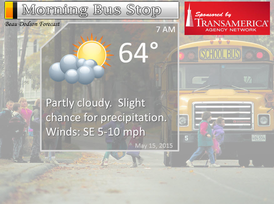
Morning School Bus Stop Weather – Partly sunny with a small chance for a shower or thunderstorm. Temperatures mostly in the 60’s.
—————————————————————————————-
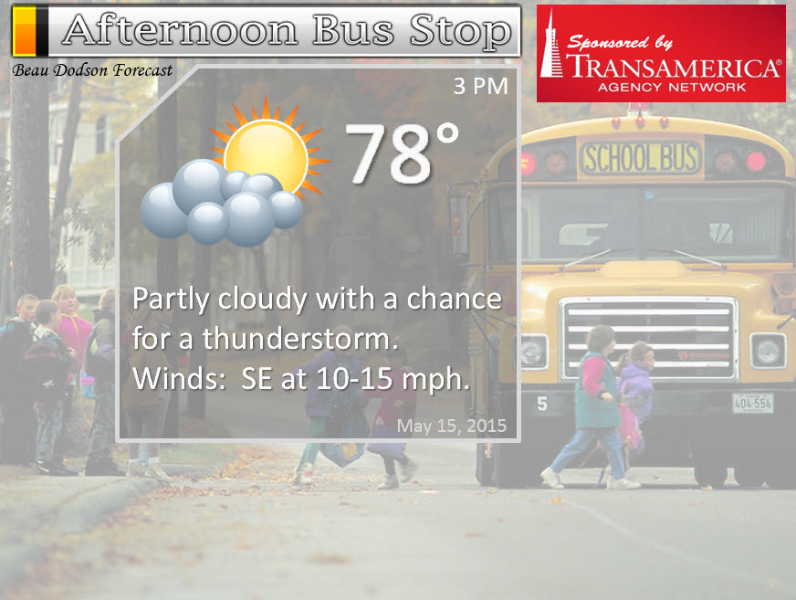
Afternoon School Bus Stop Weather – Partly sunny with a chance for a scattered thunderstorm. Highs around 80 degrees.
Friday night – Cloudy with a chance for a thunderstorm. Evening storms could produce brief heavy rain and gusty winds. More humid and milder. Lows in the 60’s. Southerly winds at 10-15 mph. Chances for precipitation at any given spot will be from 40%-60%.
My confidence in this part of the forecast verifying is medium
Should I cancel my outdoor plans? A chance for some precipitation in the area
Saturday – Partly sunny with a good chance for scattered showers and thunderstorms. Highs in the upper 70’s to around 80 degrees. Southerly winds at 10-15 mph. Chances for precipitation at any given spot will be in the 50%-70% range. Locally heavy rain likely in thunderstorms. Gusty winds and lightning.
My confidence in this part of the forecast verifying is medium
Should I cancel my outdoor plans? Have a plan B.
Saturday night – Some clouds. A scattered shower and thunderstorm possible, especially early in the evening. Lows in the 60’s. Southerly winds at 10 mph.
My confidence in this part of the forecast verifying is medium
Should I cancel my outdoor plans? A chance for some precipitation in the area
Sunday – Partly to mostly cloudy with scattered thunderstorms possible. Any storms that form could produce frequent cloud to ground lightning, gusty winds, small hail, and heavy rain. Highs mostly in the 80’s with south/southwest winds at 10-15 mph. Gusty near storms.
My confidence in this part of the forecast verifying is medium
Should I cancel my outdoor plans? Have a plan B.
Sunday night – Partly cloudy with a chance for scattered thunderstorms. Locally heavy rain in storms that do form. Gusty winds, as well. Lows around 70 degrees. South and southwest winds at 10-15 mph.
My confidence in this part of the forecast verifying is medium
Should I cancel my outdoor plans? Have a plan B.
Monday – Cold front arrives on Monday and this will bring an end to precipitation chances. Timing of the front on Monday will need to be worked out. Showers and thunderstorms will accompany the front. Cooler by Tuesday and Wednesday.
Have you checked out my social media feed page? You can view the latest Tweets and Facebook posts…all in one location. Click here to view the page.
![]()
Sunrise and Sunset Times – Click Here

The School Bus Stop Forecast is sponsored by TransAmerica Agency Network Paducah District – you can visit their Facebook page here and their home page here
Current Temperatures Around The Local Area


Don’t forget to check out the Southern Illinois Weather Observatory web-site for weather maps, tower cams, scanner feeds, radars, and much more! Click here

An explanation of what is happening in the atmosphere over the coming days…
Highlights
1. Here comes the weekend forecast, so of course we have rain to deal with.
2. Not concerned about organized severe weather over the coming days. The good news.
3. Some locally heavy rain not out of the question over the weekend, but that won’t happen everywhere.
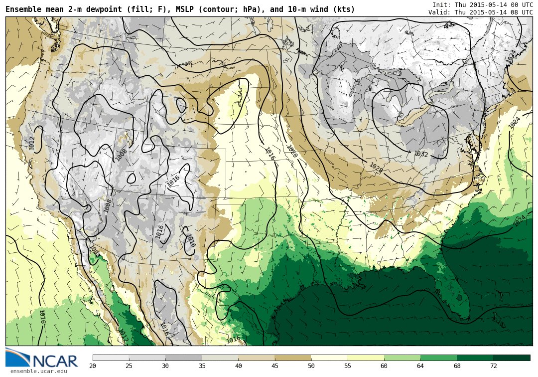
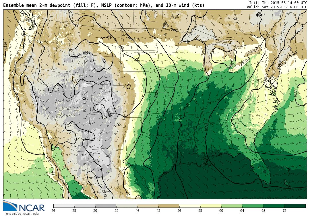
Moisture is on the increase! Check out the differences on the dew point maps from Thursday into Friday. That is one big jump in dew points. You will start to feel the difference in the air over the coming days.
Here is the Thursday dew point map
And here is the Friday forecast dew point map. Big leap in the numbers. That dark green represents dew points well into the 60’s.
It really does seem like a repeat forecast from last weekend. I seem to remember saying the same thing to everyone! Have a plan B in the back of your pocket. Rain and thunderstorm chances will be with us on Friday through Monday.
Some indications that the most widespread precipitation will be on Saturday and Saturday evening and then again on Monday (along the cold front).
Any storms that form over the coming days could produce locally heavy rain, lightning, gusty winds, and pea to dime size hail. Organized severe weather does not appear to be a concern, at this time. As always, monitor updates.
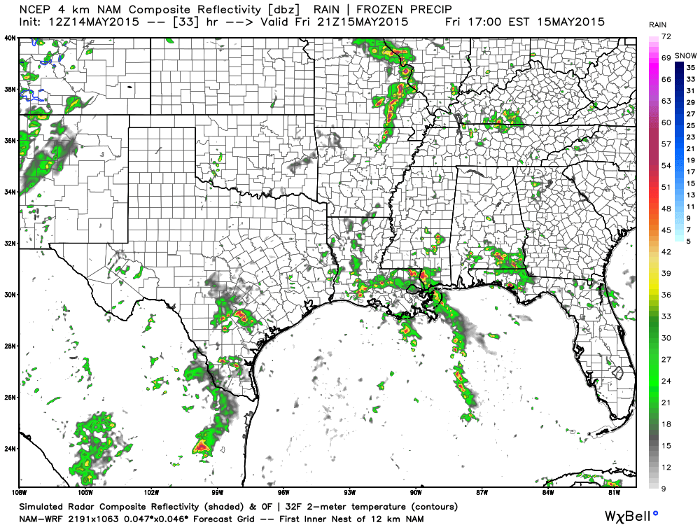
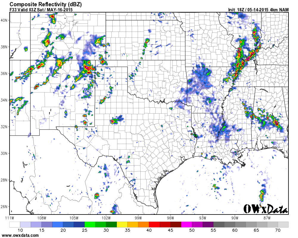
Let’s look at the high resolution WRF model. Future-cast radar for Friday. You can see several showers and thunderstorms in the region.
This is the 2 pm to 4 pm time frame on Friday. What radar might look like. Again, this is a models forecast. It is rarely exact, but you get the idea.
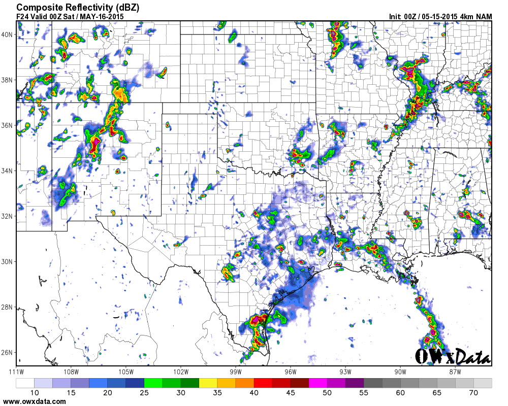
This is the Friday evening forecast from the WRF model. Different view of this. If this model is correct then we will have some heavy storms in the area. Not expecting organized severe storms, but some cloud to ground lightning, heavy rain, and gusty winds would be possible.
As far as the severe weather concerns…
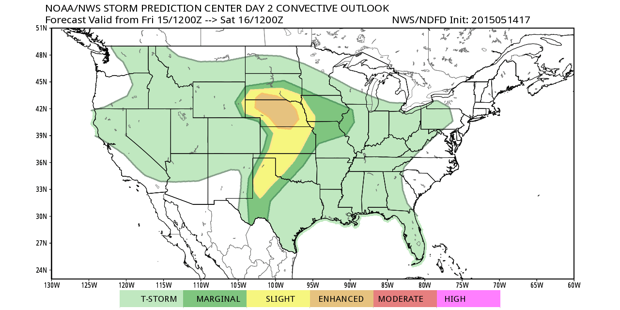
The Storm Prediction Center, who make the official severe weather outlooks, have outlined areas well to our west for severe weather on Friday and Saturday. We are in the general thunderstorm area (below severe levels).
Parts of the Central U.S. will be busy, however, as they have been outlined for severe storms. Saturday is shaping up to be a busy day for some NWS offices.
Rainfall totals will vary GREATLY across the region. Same as last weekend. Some places will make out like bandits with the rainfall totals and others will wonder what all the fuss is about. Typical for spring. It isn’t just one cold front sweeping through the area with a band of showers and thunderstorms. It is a series of weak disturbances that will move through the upper levels. Each one will spark some precipitation.
Bottom line is to keep an eye on the radars and check back for updated information. If you have an outdoor event then have a plan B handy. I would not cancel any plans. I would just be prepared.
WEATHER RADAR PAGE – Click here —
We also have a new national interactive radar – you can view that radar by clicking here.
Don’t forget to support our sponsors!

No major concerns. Thunderstorms will be possible over the coming days. Organized severe weather is not anticipated. Cloud to ground lightning is possible and heavy downpours. I guess if I had a concern it would be for your outdoor activities. Don’t forget that thunderstorms can always produce isolated high winds or a down burst. This is not something that is considered organized severe weather.

Umbrellas might be needed from time to time from Friday into Monday. If you have outdoor plans over the weekend then have a plan B. Always good to have a plan B during the Month of May!
Check out our sponsors! There are more on the right side bar of the page, as well. Be sure and let them know that you appreciate their sponsorship of the WeatherTalk daily weather bulletin.

Premier Portable Buildings proudly serving our region. For more information click the above ad or here
They can also be found on this Facebook page
G&C Multi-Services out of Paducah, Kentucky. G & C Multi-Services is a service provider in Western Kentucky that provides industrial and commercial equipment fabrication, machine troubleshooting, repair and maintenance, and installation. They can custom fabricate steel, stainless, and aluminum products per customer specifications.
Visit their web-site here. Or click the ad below! Facebook page.


Wortham Dental Care located in Paducah, Kentucky. The gentle dentist. Mercury free dentistry. They also do safe Mercury removal. You can find Wortham Dental Care on Facebook, as well

Trover’s Equipment and Lawn Care – Family owned and operated! They are a dealer for Snapper, Simplicity, Snapper Pro, Bad Boy Mowers, and Intimidator Utility Vehicles. They are a Stihl and Dolmar power products dealer. They also are a dealer for Briggs & Stratton, Kohler gas & diesel engines, and Kawasaki engines. They service and repair just about any brand. You can find them on Facebook, as well

Visit their web-site here. Or, you can also visit their Facebook page.

Endrizzi’s Storm Shelters – For more information click here. Endrizzi Contracting and Landscaping can be found on Facebook, as well – click here

Gary Eckelkamp’s web-site click the above banner or click here
.

Here are the current river stage forecasts. You can click your state and then the dot for your location. It will bring up the full forecast and hydrograph.
Click Here For River Stage Forecasts…

The wild card tells you where the uncertainties are in the forecast
Wild card in this forecast – The wild card on Friday will be rainfall coverage. A few showers and thunderstorms will be possible. Better chances arrive on Saturday.

Can we expect severe thunderstorms over the next 24 to 48 hours? Remember that a severe thunderstorm is defined as a thunderstorm that produces 58 mph winds or higher, quarter size hail or larger, and/or a tornado.
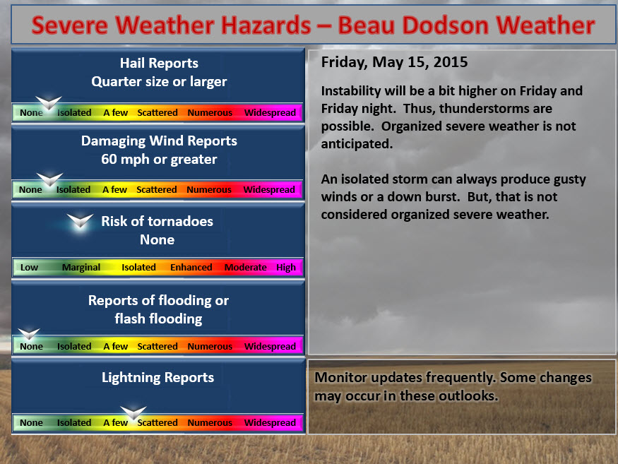
Thunderstorm threat level is ONE on FRIDAY and ONE on Saturday. Some thunder is possible. Not expecting severe weather. Again, thunderstorms can always produce an isolated down burst or report of high winds.
For Friday…threat level is ONE.

.
And Saturday’s graphic
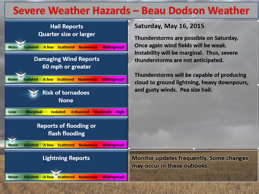
Friday Severe Weather Outlook – Thunder possible. Right now it does not look like organized severe weather will be a concern, but monitor updates. Keep in mind that when you have a thunderstorm, during this time of the year, that you can always have a very isolated report of high winds, a down burst, and so on.
.
Saturday Severe Weather Outlook – Thunder possible. Right now it does not look like severe weather will be a concern, but monitor updates. Keep in mind that when you have a thunderstorm, during this time of the year, that you can always have a very isolated report of high winds, a down burst, and so on.
.
Sunday Severe Weather Outlook – Thunder possible. Right now it does not look like severe weather will be a concern, but monitor updates. Keep in mind that when you have a thunderstorm, during this time of the year, that you can always have a very isolated report of high winds, a down burst, and so on.
.
Monday – Thunderstorms possible. Monitor updates.
Tuesday – We should dry out by Tuesday and Wednesday with no threat of severe weather.

How much precipitation should we expect over the next few days?
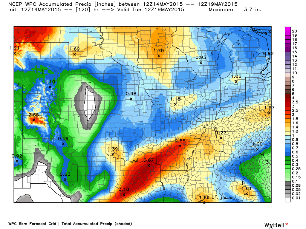
Once again, same as last week, the rain amounts are going to vary widely over our region. Slow moving thunderstorms can always produce locally heavy rainfall totals. Some of you picked up 1-6 inches of rain last week and weekend. Some of you picked up nothing!
Here is the latest outlook through Tuesday. Again, amount will vary and you won’t all end up with what this map shows. You know how this goes in May!

This section of the blog is speculative forecast information. Because it is past the range of what meteorologists can forecast accurately, it should be considered speculation. Anything past day 5 is considered a long range forecast.
Highlights
1. Cold front arrives on Monday
2. Cooler by Tuesday/Wednesday
3. Will rain chances return by next weekend, again
Just like last week, a cold front will sweep through the area on Monday. This will usher in cooler air for Tuesday and Wednesday. We might see temperatures back into the 40’s at some locations. No concerns for frost.
The big question in the long range is how quick does precipitation return to our region. Data suggests perhaps as early as Wednesday night and Thursday. There is a decent amount of disagreement, however, on the exact timing and strength of the next storm system.
Pretty sure we will have precipitation chances returning late next week. Repeat of the last few weekends? Seems possible. We are not on the best footing for weekends. This is like hitting the red light at every intersection.
Some data attempts to bring an area of high pressure into the region from the north on Thursday and Friday. This is while a new storm system takes shape to our west and southwest. Might end up a big of a battle between the two. Which one wins will determine whether rain will occur again next weekend.
The EC model brings a stronger system into our region by Sunday and Monday. This will need to be monitored.
Above normal precipitation is likely from this weekend until the end of the month. Some of you need rain, so this is not bad news.

We have regional radars and local city radars – if a radar does not seem to be updating then try another one. Occasional browsers need their cache cleared. You may also try restarting your browser. That usually fixes the problem. Occasionally we do have a radar go down. That is why I have duplicates. Thus, if one fails then try another one.
If you have any problems then please send me an email beaudodson@usawx.com
WEATHER RADAR PAGE – Click here —
We also have a new national interactive radar – you can view that radar by clicking here.
Local interactive city radars include St Louis, Mt Vernon, Evansville, Poplar Bluff, Cape Girardeau, Marion, Paducah, Hopkinsville, Memphis, Nashville, Dyersburg, and all of eastern Kentucky – these are interactive radars. Local city radars – click here
NOTE: Occasionally you will see ground clutter on the radar (these are false echoes). Normally they show up close to the radar sites – including Paducah.

Regional Radar – Click on radar to take you our full radar page.


Regional Radar
![]()
Current WARNINGS (a warning means take action now). Click on your county to drill down to the latest warning information. Keep in mind that there can be a 2-3 minute delay in the updated warning information.
I strongly encourage you to use a NOAA Weather Radio or warning cell phone app for the most up to date warning information. Nothing is faster than a NOAA weather radio.


Color shaded counties are under some type of watch, warning, advisory, or special weather statement. Click your county to view the latest information.

Missouri Warnings

Illinois Warnings

Kentucky Warnings

Please visit your local National Weather Service Office by clicking here. The National Weather Service Office, for our region, is located in Paducah, Kentucky. They have a lot of maps and information on their site. Local people…local forecasters who care about our region.

Here is the official 6-10 day and 8-14 day temperature and precipitation outlook. Check the date stamp at the top of each image (so you understand the time frame).
The forecast maps below are issued by the Weather Prediction Center (NOAA).


The latest 8-14 day temperature and precipitation outlook. Note the dates are at the top of the image. These maps DO NOT tell you how high or low temperatures or precipitation will be. They simply give you the probability as to whether temperatures or precipitation will be above or below normal.


Who do you trust for your weather information and who holds them accountable?
I have studied weather in our region since the late 1970’s. I have 37 years of experience in observing our regions weather patterns. My degree is in Broadcast Meteorology from Mississippi State University and an Associate of Science (AS). I am currently working on my Bachelor’s Degree in Geoscience. Just need to finish two Spanish classes!
I am a member of the American Meteorological Society. I am a NOAA Weather-Ready Nation Ambassador. And, I am the Meteorologist for McCracken County Emergency Management.
I own and operate the Southern Illinois Weather Observatory.
There is a lot of noise on the internet. A lot of weather maps are posted without explanation. Over time you should learn who to trust for your weather information.
My forecast philosophy is simple and straight forward.
- Communicate in simple terms
- To be as accurate as possible within a reasonable time frame before an event
- Interact with you on Twitter, Facebook, and the blog
- Minimize the “hype” that you might see on television or through other weather sources
- Push you towards utilizing wall-to-wall LOCAL TV coverage during severe weather events
I am a recipient of the Mark Trail Award, WPSD Six Who Make A Difference Award, Kentucky Colonel, and the Caesar J. Fiamma” Award from the American Red Cross. In 2009 I was presented with the Kentucky Office of Highway Safety Award. I was recognized by the Kentucky House of Representatives for my service to the State of Kentucky leading up to several winter storms and severe weather outbreaks.
If you click on the image below you can read the Kentucky House of Representatives Resolution.

I am also President of the Shadow Angel Foundation which serves portions of western Kentucky and southern Illinois.
Many of my graphics are from www.weatherbell.com – a great resource for weather data, model data, and more


This blog was inspired by ABC 33/40’s Alabama Weather Blog – view their blog
Current tower cam view from the Weather Observatory- Click here for all cameras.

Southern Illinois Weather Observatory

The Weather Observatory

Southern Illinois Weather Observatory
WSIL TV 3 has a number of tower cameras. Click here for their tower camera page & Illinois Road Conditions

Marion, Illinois
WPSD TV 6 has a number of tower cameras. Click here for their tower camera page & Kentucky Road Conditions & Kentucky Highway and Interstate Cameras

Downtown Paducah, Kentucky
Benton, Kentucky Tower Camera – Click here for full view

Benton, Kentucky

I24 Paducah, Kentucky

I24 Mile Point 9 – Paducah, KY

I24 – Mile Point 3 Paducah, Kentucky

You can sign up for my AWARE email by clicking here I typically send out AWARE emails before severe weather, winter storms, or other active weather situations. I do not email watches or warnings. The emails are a basic “heads up” concerning incoming weather conditions.