Afternoon update.
An area of thunderstorms is forming over western and central Missouri. The storms will move east over the coming hours. Some of these storms will approach southeast Missouri and southwest Illinois towards evening.
These storms could produce heavy rain, gusty winds, and lightning. I can’t rule out hail.
There is a chance that a couple of storms could be near or at severe levels. This would mainly be across southeast Missouri and southern Illinois. The further west and northwest you travel the more likely you will experience thunderstorms.
Updated forecast
May 14, 2018
Monday Forecast Details
Forecast: Partly to mostly sunny. Hot. A late afternoon thunderstorm possible over southeast Missouri and perhaps southwest Illinois. Heat index value above 95 degrees.
Temperatures: MO ~ 90 to 94 IL ~ 90 to 94 KY ~ 90 to 94 TN ~ 90 to 94
What is the chance of precipitation? MO ~ 30% IL ~ 30% KY ~ 10% TN ~ 10%
Coverage of precipitation: Isolated late in the day (coming in from the west/northwest)
Winds: South and southwest at 6 to 12 mph and gusty
What impacts are anticipated from the weather? None to isolated wet roads and lightning.
My confidence in the forecast verifying: High
Is severe weather expected? Some storms could be intense over southeast Missouri and southwest Illinois.
The NWS defines severe weather as 58 mph wind or great, 1″ hail or larger, and/or tornadoes
Should I cancel my outdoor plans? No, but check radars late in the day
UV Index: 8 – very high
Sunrise: 5:47 AM
Monday Night Forecast Details:
Forecast: Partly cloudy. A thunderstorm possible. The highest coverage will likely be across southeast MO and southern IL. A few intense storms possible.
Temperatures: MO ~ 68 to 72 IL ~ 68 to 72 KY ~ 68 to 74 TN ~ 70 to 74
What is the chance of precipitation? MO ~ 40% IL ~ 40% KY ~ 30% TN ~ 20%
Coverage of precipitation: Scattered to perhaps a period of numerous storms over southeast Missouri and southern Illinois.
Winds: Southwest at 5 to 10 mph
What impacts are anticipated from the weather? Wet roadways. Lightning. Strong winds near storms. A low end risk of hail.
My confidence in the forecast verifying: Medium
Is severe weather expected? A severe thunderstorm can’t be ruled out this evening.
The NWS defines severe weather as 58 mph wind or great, 1″ hail or larger, and/or tornadoes
Should I cancel my outdoor plans? No, but monitor radars
Sunset: 7:55 PM
Moonrise: 5:31 AM Waning Crescent
Moonset: 7:07 PM
WeatherTalk monthly operating costs can top $2000.00. Your $3 subscription helps pay for those costs. I work for you.
For $3 a month you can receive the following. You may choose to receive these via your WeatherTalk app or regular text messaging.
- Severe weather app/text alerts from my keyboard to your app/cell phone. These are hand typed by Beau. During tornado outbreaks, you will receive numerous app/text messages telling you exactly where the tornado is located.
- Daily forecast app/texts from my computer to your app/cell phone.
- Social media links sent directly to your app/cell phone. When I update the blog, videos, or Facebook you will receive the link.
- AWARE emails. These emails keep you well ahead of the storm. They give you several days of lead time before significant weather events.
- Direct access to Beau via text and email. Your very own personal meteorologist. I work for you!
- Missouri and Ohio Valley centered video updates
- Long-range weather videos
- Week one, two, three and four temperature and precipitation outlooks.
- Monthly outlooks.
- Your subscription also will help support several local charities.
Haven’t you subscribed? Subscribe at www.beaudodsonweather.com

Example of a recent severe weather alert. I issued this well before the official tornado warning. You would have had plenty of time for you and your family to seek shelter.


Your $3 per month also helps support these local charity projects.

I encourage subscribers to use the app vs regular text messaging. We have found text messaging to be delayed during severe weather. The app typically will receive the messages instantly. I recommend people have three to four methods of receiving their severe weather information.
Remember, my app and text alerts are hand typed and not computer generated. You are being given personal attention during significant weather events.

WWW.WEATHERTALK.COM subscribers, here is my day to day schedule for your weather products.


May 14, 2018
Monday Forecast Details
Forecast: Partly to mostly sunny. Hot. A late afternoon thunderstorm possible over southeast Missouri and perhaps southwest Illinois. Heat index value above 95 degrees.
Temperatures: MO ~ 90 to 94 IL ~ 90 to 94 KY ~ 90 to 94 TN ~ 90 to 94
What is the chance of precipitation? MO ~ 30% IL ~ 30% KY ~ 10% TN ~ 10%
Coverage of precipitation: Isolated late in the day (coming in from the west/northwest)
Winds: South and southwest at 6 to 12 mph and gusty
What impacts are anticipated from the weather? None to isolated wet roads and lightning.
My confidence in the forecast verifying: High
Is severe weather expected? Some storms could be intense over southeast Missouri and southwest Illinois.
The NWS defines severe weather as 58 mph wind or great, 1″ hail or larger, and/or tornadoes
Should I cancel my outdoor plans? No, but check radars late in the day
UV Index: 8 – very high
Sunrise: 5:47 AM
Monday Night Forecast Details:
Forecast: Partly cloudy. A thunderstorm possible. The highest coverage will likely be across southeast MO and southern IL. A few intense storms possible.
Temperatures: MO ~ 68 to 72 IL ~ 68 to 72 KY ~ 68 to 74 TN ~ 70 to 74
What is the chance of precipitation? MO ~ 40% IL ~ 40% KY ~ 30% TN ~ 20%
Coverage of precipitation: Scattered to perhaps a period of numerous storms over southeast Missouri and southern Illinois.
Winds: Southwest at 5 to 10 mph
What impacts are anticipated from the weather? Wet roadways. Lightning. Strong winds near storms. A low end risk of hail.
My confidence in the forecast verifying: Medium
Is severe weather expected? A severe thunderstorm can’t be ruled out this evening.
The NWS defines severe weather as 58 mph wind or great, 1″ hail or larger, and/or tornadoes
Should I cancel my outdoor plans? No, but monitor radars
Sunset: 7:55 PM
Moonrise: 5:31 AM Waning Crescent
Moonset: 7:07 PM
An unsettled weather pattern is developing Tuesday into the foreseeable future. On and off scattered showers and thunderstorms are going to be in the forecast daily. It won’t rain all day. There will be showers and storms on radar from time to time. I am sure there will be periods of greater coverage. Those details will need to be ironed out moving forward.
May 15, 2018
Tuesday Forecast Details
Forecast: Partly sunny. Very warm. Humid. Scattered showers and thunderstorms possible.
Temperatures: MO ~ 86 to 92 IL ~ 86 to 92 KY ~ 86 to 92 TN ~ 86 to 92
What is the chance of precipitation? MO ~ 30% IL ~ 30% KY ~ 30% TN ~ 30%
Coverage of precipitation: Scattered
Winds: South and southwest at 6 to 12 mph with higher gusts around storms
What impacts are anticipated from the weather? Wet roadways and lightning.
My confidence in the forecast verifying: High
Is severe weather expected? At this time, the risk appears low. Monitor updates.
The NWS defines severe weather as 58 mph wind or great, 1″ hail or larger, and/or tornadoes
Should I cancel my outdoor plans? No, but monitor radars
UV Index: 8 – very high
Sunrise: 5:46 AM
Tuesday Night Forecast Details:
Forecast: Partly cloudy. Scattered showers and thunderstorms.
Temperatures: MO ~ 64 to 68 IL ~ 64 to 68 KY ~ 65 to 68 TN ~ 65 to 68
What is the chance of precipitation? MO ~ 50% IL ~ 50% KY ~ 30% TN ~ 30%
Coverage of precipitation: Scattered
Winds: Southwest winds becoming more variable as a boundary moves through the region. Winds may turn out of the northwest and north, at times. Speeds 5 to 10 mph with gusts to 15
What impacts are anticipated from the weather? Scattered wet roadways. Lightning.
My confidence in the forecast verifying: Medium
Is severe weather expected? At this time, the risk appears low. Monitor updates.
The NWS defines severe weather as 58 mph wind or great, 1″ hail or larger, and/or tornadoes
Should I cancel my outdoor plans? No, but monitor updates and radars
Sunset: 7:56 PM
Moonrise: 6:11 AM New
Moonset: 8:16 PM
May 16, 2018
Wednesday Forecast Details
Forecast: A mix of sun and clouds. Scattered showers and thunderstorms.
Temperatures: MO ~ 84 to 88 IL ~ 84 to 88 KY ~ 84 to 88 TN ~ 84 to 88
What is the chance of precipitation? MO ~ 40% IL ~ 40% KY ~ 40% TN ~ 40%
Coverage of precipitation: Scattered
Winds: Variable winds at 5 to 10 mph with gusts to 14
What impacts are anticipated from the weather? Scattered wet roadways and lightning.
My confidence in the forecast verifying: Medium
Is severe weather expected? At this time, the risk appears low. Monitor updates.
The NWS defines severe weather as 58 mph wind or great, 1″ hail or larger, and/or tornadoes
Should I cancel my outdoor plans? No, but monitor updates and radars
UV Index: 5 – Medium to high
Sunrise: 5:45 AM
Wednesday Night Forecast Details:
Forecast: Mostly cloudy. Scattered showers and thunderstorms.
Temperatures: MO ~ 65 to 68 IL ~ 65 to 68 KY ~ 65 to 70 TN ~ 65 to 70
What is the chance of precipitation? MO ~ 40% IL ~ 40% KY ~ 40% TN ~ 40%
Coverage of precipitation: Scattered
Winds: South and southwest at 6 to 12 mph
What impacts are anticipated from the weather? Scattered wet roadways. Lightning.
My confidence in the forecast verifying: Medium
Is severe weather expected? At this time, the risk appears low. Monitor updates.
The NWS defines severe weather as 58 mph wind or great, 1″ hail or larger, and/or tornadoes
Should I cancel my outdoor plans? No, but monitor updates and radars
Sunset: 7:57 PM
Moonrise: 6:56 AM Waxing Crescent
Moonset: 9:25 PM
May 17, 2018
Thursday Forecast Details
Forecast: Mostly cloudy. Scattered showers and thunderstorms.
Temperatures: MO ~ 80 to 85 IL ~ 80 to 85 KY ~ 80 to 85 TN ~ 80 to 85
What is the chance of precipitation? MO ~ 40% IL ~ 40% KY ~ 50% TN ~ 50%
Coverage of precipitation: Scattered
Winds: East wind 5 to 10 mph with gusts to 15 mph
What impacts are anticipated from the weather? Scattered wet roadways and lightning.
My confidence in the forecast verifying: Medium
Is severe weather expected? At this time, the risk appears low. Monitor updates.
The NWS defines severe weather as 58 mph wind or great, 1″ hail or larger, and/or tornadoes
Should I cancel my outdoor plans? No, but monitor updates
UV Index: 4 – moderate
Sunrise: 5:44 AM
Thursday Night Forecast Details:
Forecast: Partly to mostly cloudy. Scattered showers and thunderstorms.
Temperatures: MO ~ 62 to 65 IL ~ 62 to 65 KY ~ 63 to 66 TN ~ 63 to 66
What is the chance of precipitation? MO ~ 40% IL ~ 40% KY ~ 40% TN ~ 40%
Coverage of precipitation: Scattered
Winds: East and northeast at 5 to 10 mph
What impacts are anticipated from the weather? Scattered wet roadways. Lightning.
My confidence in the forecast verifying: Medium
Is severe weather expected? At this time, the risk appears low. Monitor updates.
The NWS defines severe weather as 58 mph wind or great, 1″ hail or larger, and/or tornadoes
Should I cancel my outdoor plans? No, but monitor updates
Sunset: 7:58 PM
Moonrise: 7:47 AM Waxing Crescent
Moonset: 10:32 PM
May 18, 2018
Friday Forecast Details
Forecast: A mix of sun and clouds. Scattered showers and thunderstorms.
Temperatures: MO ~ 83 to 86 IL ~ 83 to 86 KY ~ 83 to 86 TN ~ 83 to 86
What is the chance of precipitation? MO ~ 30% IL ~ 30% KY ~ 30% TN ~ 30%
Coverage of precipitation: Scattered
Winds: Variable winds at 6 to 12 mph
What impacts are anticipated from the weather? Scattered wet roadways and lightning.
My confidence in the forecast verifying: Medium
Is severe weather expected? At this time, the risk appears low. Monitor updates.
The NWS defines severe weather as 58 mph wind or great, 1″ hail or larger, and/or tornadoes
Should I cancel my outdoor plans? No, but monitor updates
UV Index: 8 – very high
Sunrise: 5:44 AM
Friday Night Forecast Details:
Forecast: Partly cloudy. Scattered thunderstorms possible.
Temperatures: MO ~ 68 to 72 IL ~ 68 to 72 KY ~ 68 to 74 TN ~ 70 to 74
What is the chance of precipitation? MO ~ 30% IL ~ 30% KY ~ 30% TN ~ 30%
Coverage of precipitation: Scattered
Winds: Southeast at 6 to 12 mph
What impacts are anticipated from the weather? Scattered wet roadways. Lightning.
My confidence in the forecast verifying: Medium
Is severe weather expected? At this time, the risk appears low. Monitor updates.
The NWS defines severe weather as 58 mph wind or great, 1″ hail or larger, and/or tornadoes
Should I cancel my outdoor plans? No, but monitor updates
Sunset: 7:59 PM
Moonrise: 8:46 AM Waxing Crescent
Moonset: 11:32 PM
May 19, 2018
Saturday Forecast Details
Forecast: Partly sunny. Scattered thunderstorms. Quite warm.
Temperatures: MO ~ 86 to 92 IL ~ 86 to 92 KY ~ 86 to 92 TN ~ 86 to 92
What is the chance of precipitation? MO ~ 20% IL ~ 20% KY ~ 30% TN ~ 30%
Coverage of precipitation: Scattered
Winds: South and southwest at 7 to 14 mph and gusty
What impacts are anticipated from the weather? Scattered wet roadways and lightning.
My confidence in the forecast verifying: LOW adjustments are likely
Is severe weather expected? At this time, the risk appears low. Monitor updates.
The NWS defines severe weather as 58 mph wind or great, 1″ hail or larger, and/or tornadoes
Should I cancel my outdoor plans? No, but monitor updates
UV Index: 8 – very high
Sunrise: 5:43 AM
Saturday Night Forecast Details:
Forecast: Partly cloudy. Mild. Isolated thunderstorms.
Temperatures: MO ~ 65 to 68 IL ~ 65 to 68 KY ~ 65 to 70 TN ~ 65 to 70
What is the chance of precipitation? MO ~ 30% IL ~ 30% KY ~ 30% TN ~ 30%
Coverage of precipitation: Scattered
Winds: South and southwest at 6 to 12 mph
What impacts are anticipated from the weather? Scattered wet roadways. Lightning.
My confidence in the forecast verifying: LOW adjustments are likely
Is severe weather expected? At this time, the risk appears low. Monitor updates.
The NWS defines severe weather as 58 mph wind or great, 1″ hail or larger, and/or tornadoes
Should I cancel my outdoor plans? No, but monitor updates
Sunset: 8:00 PM
Moonrise: 9:49 AM Waxing Crescent
Moonset: 12:01 AM
May 20, 2018
Sunday Forecast Details
Forecast: Partly cloudy. A chance of showers and thunderstorms.
Temperatures: MO ~ 86 to 92 IL ~ 86 to 92 KY ~ 86 to 92 TN ~ 86 to 92
What is the chance of precipitation? MO ~ 30% IL ~ 30% KY ~ 30% TN ~ 30%
Coverage of precipitation: Scattered
Winds: South at 6 to 12 mph
What impacts are anticipated from the weather? Wet roads. Lightning.
My confidence in the forecast verifying: LOW adjustments are likely
Is severe weather expected?
The NWS defines severe weather as 58 mph wind or great, 1″ hail or larger, and/or tornadoes
Should I cancel my outdoor plans?
UV Index: 8 – very high
Sunrise: 5:42 AM
Sunday Night Forecast Details:
Forecast: Partly cloudy. A shower or thunderstorm possible.
Temperatures: MO ~ 64 to 68 IL ~ 64 to 68 KY ~ 64 to 68 TN ~ 64 to 68
What is the chance of precipitation? MO ~ 20% IL ~ 20% KY ~ 20% TN ~ 20%
Coverage of precipitation:
Winds: South at 5 to 10 mph
What impacts are anticipated from the weather?
My confidence in the forecast verifying: LOW adjustments are likely
Is severe weather expected?
The NWS defines severe weather as 58 mph wind or great, 1″ hail or larger, and/or tornadoes
Should I cancel my outdoor plans?
Sunset: 8:00 PM
Moonrise: 10:56 AM Waxing Crescent
Moonset: 12:27 AM
May 21, 2018
Monday Forecast Details
Forecast: Partly cloudy.
Temperatures: MO ~ 80 to 85 IL ~ 80 to 85 KY ~ 80 to 85 TN ~ 80 to 85
What is the chance of precipitation? MO ~ 10% IL ~ 10% KY ~ 10% TN ~ 10%
Coverage of precipitation:
Winds: South at 5 to 10 mph
What impacts are anticipated from the weather?
My confidence in the forecast verifying: Medium
Is severe weather expected?
The NWS defines severe weather as 58 mph wind or great, 1″ hail or larger, and/or tornadoes
Should I cancel my outdoor plans?
UV Index: 7 – high
Sunrise: 5:41 AM
Monday Night Forecast Details:
Forecast: Partly cloudy.
Temperatures: MO ~ 64 to 68 IL ~ 64 to 68 KY ~ 64 to 68 TN ~ 64 to 68
What is the chance of precipitation? MO ~ 0% IL ~ 0% KY ~ 0% TN ~ 0%
Coverage of precipitation:
Winds: South at 5 to 10 mph
What impacts are anticipated from the weather?
My confidence in the forecast verifying: Medium
Is severe weather expected?
The NWS defines severe weather as 58 mph wind or great, 1″ hail or larger, and/or tornadoes
Should I cancel my outdoor plans?
Sunset: 8:01 PM
Moonrise: 12:03 PM Waxing Crescent
Moonset: 1:14 AM
RAIN TOTALS
We will see increasing rain chances beginning as early as late this afternoon and tonight across southeast Missouri and southwest Illinois (perhaps spreading eastward).
On and off rain chances Tuesday, Wednesday, Thursday, Friday, Saturday, and Sunday. It will not rain all the time. There will be dry periods. The weather will, however, be unsettled.
It is important to remember, late spring and summer thunderstorms can drop a lot of rain in a short amount of time. Rain rates can occasionally exceed 1.5 to 2″ per hour. This can cause brief periods of flash flooding or ponding of water.
It is next to impossible to forecast which county will receive more rain than a neighboring county. Typical, for our region. Your neighbor can pick up a heavy thunderstorm and you end up with just a few drops.
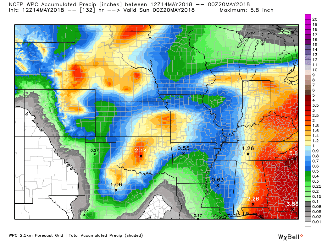
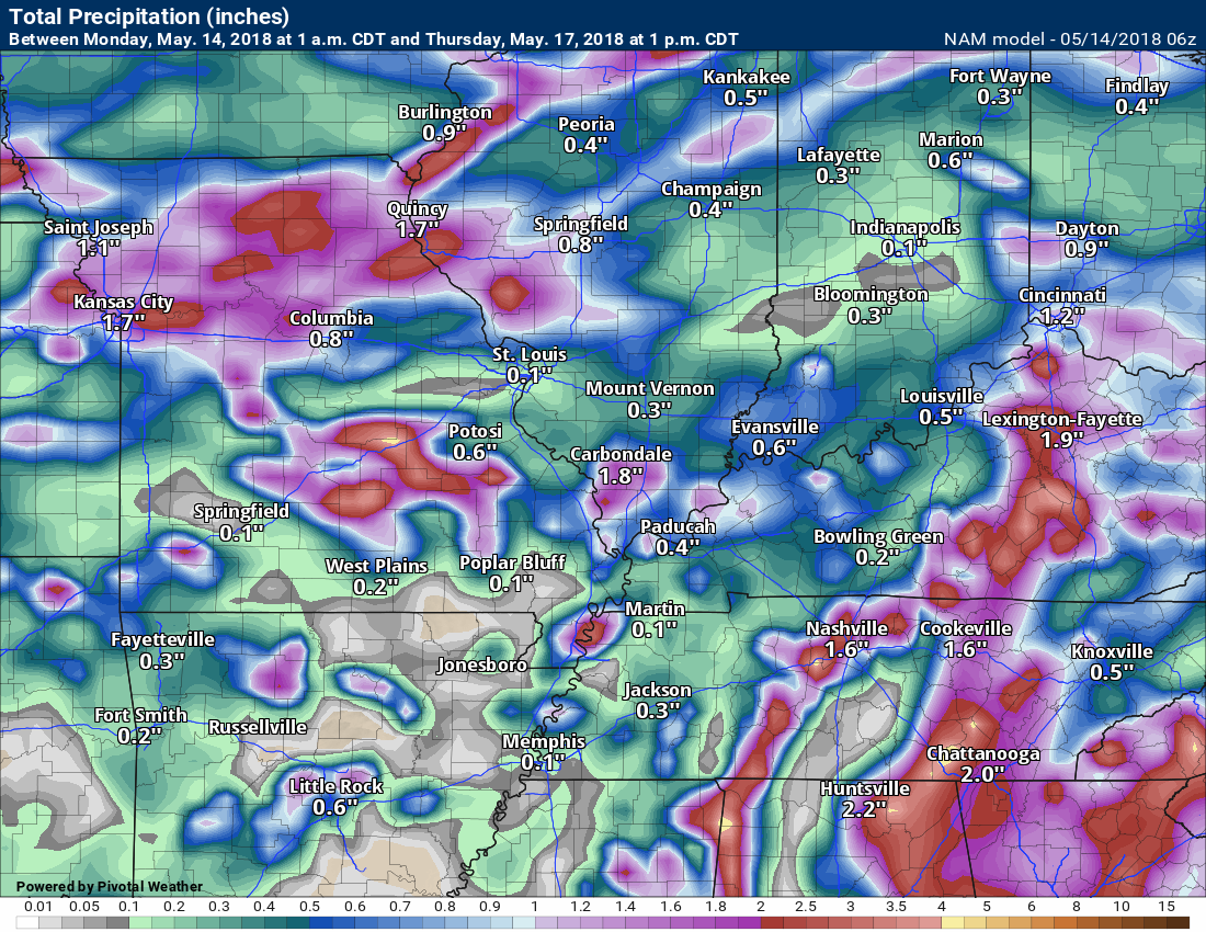
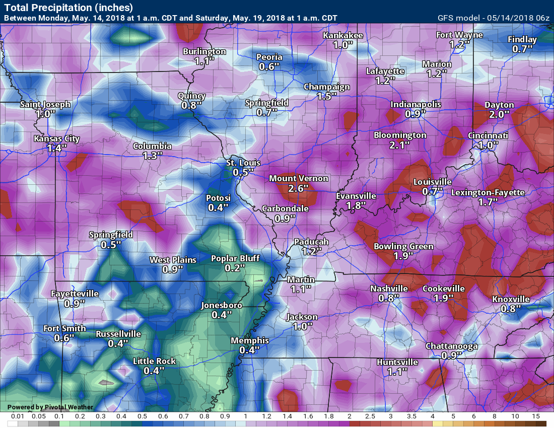
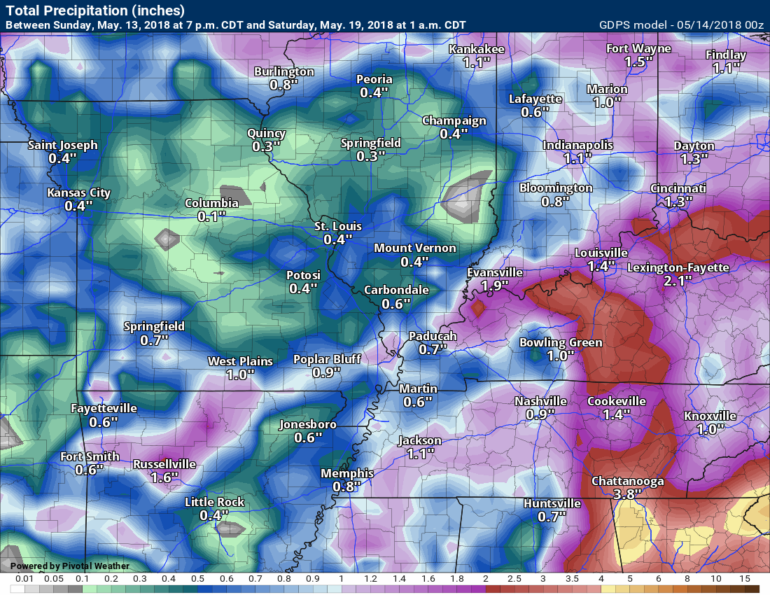
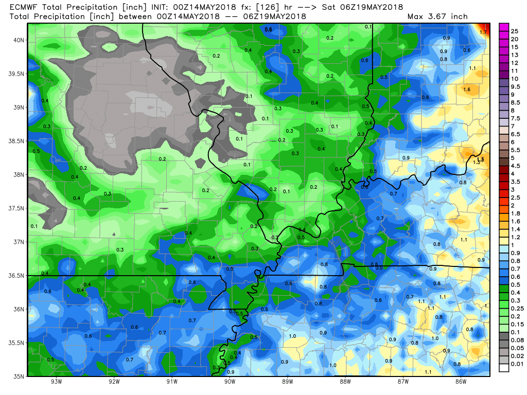
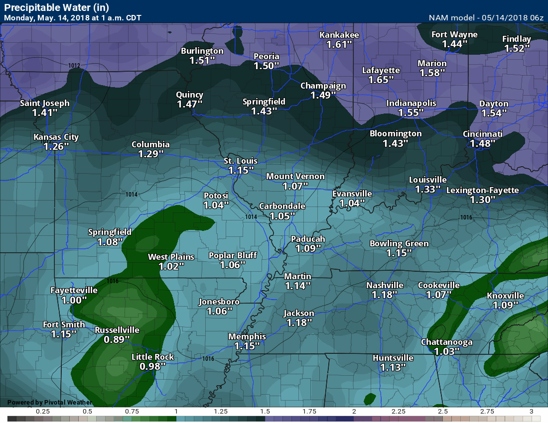
Here are the current rainfall forecast numbers from the WPC and model guidance.
Again, thunderstorms can easily double or triple these numbers.
WPC/NOAA through 7 PM Saturday
NAM short range model through Thursday at 1 PM
Again, models won’t handle scattered thunderstorms all that well. Take the general idea that we are anticipating rain over the coming days. Some thunderstorms will produce downpours.
GFS model guidance through 1 AM Saturday
GEM model guidance through 1 AM Saturday
EC model guidance through 1 AM Saturday

Interactive Radars:
Interactive live weather radar page. Choose the city nearest your location. If one of the city radars won’t load then try a nearby one. Click here.

Questions? Broken links? Other?
You may email me at beaudodson@usawx.com

The National Weather Service defines a severe thunderstorm as one that produces quarter size hail or larger, 58 mph winds or greater, and/or a tornado.
Monday through Sunday: Thunderstorms will be possible beginning late Monday afternoon and continuing into Sunday. Some of the storms could produce frequent lightning, gusty winds, heavy rain, and even small hail.
There will be a low risk of severe weather. I will need to monitor each day and how much instability builds. It is possible that a few thunderstorms could reach severe levels.
At this time, widespread severe weather appears unlikely. As always, monitor updates.
![]()
Interactive live weather radar page. Choose the city nearest your location. If one of the cities does not work then try a nearby one. Click here.
National map of weather watches and warnings. Click here.
Storm Prediction Center. Click here.
Weather Prediction Center. Click here.

Live lightning data: Click here.

Interactive GOES R satellite. Track clouds. Click here.

Here are the latest local river stage forecast numbers Click Here.
Here are the latest lake stage forecast numbers for Kentucky Lake and Lake Barkley Click Here.

The spring and preliminary summer outlooks have been posted for subscribers. Scroll down to see the outlook.
Not a subscriber? Learn more at this link.

Weather Headlines
- Warm and humid conditions.
- Increasing shower and thunderstorm chances.
I hope everyone had a nice Mother’s Day weekend. The weather was certainly warm enough. Temperatures were WELL above normal.
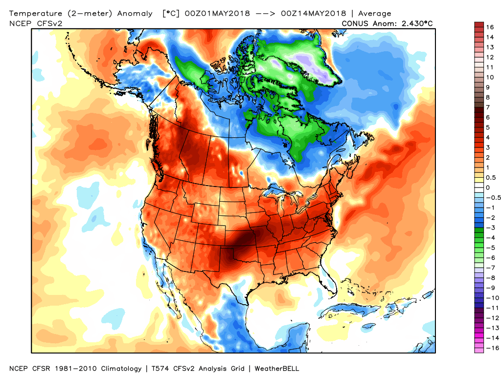
Temperatures, for the Month of May, have been well above normal across much of the nation.
Check out this temperature anomaly map from May 1st through yesterday. This shows you how many degrees temperatures have been above or below normal.
A sea of red. Well above normal across our region (darker reds).
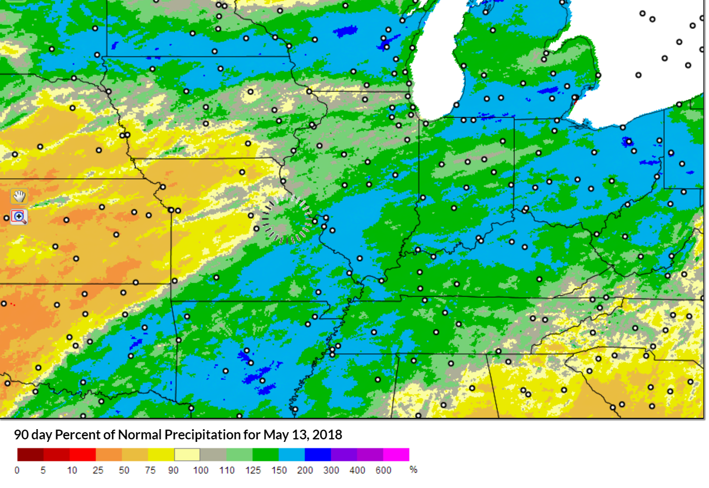
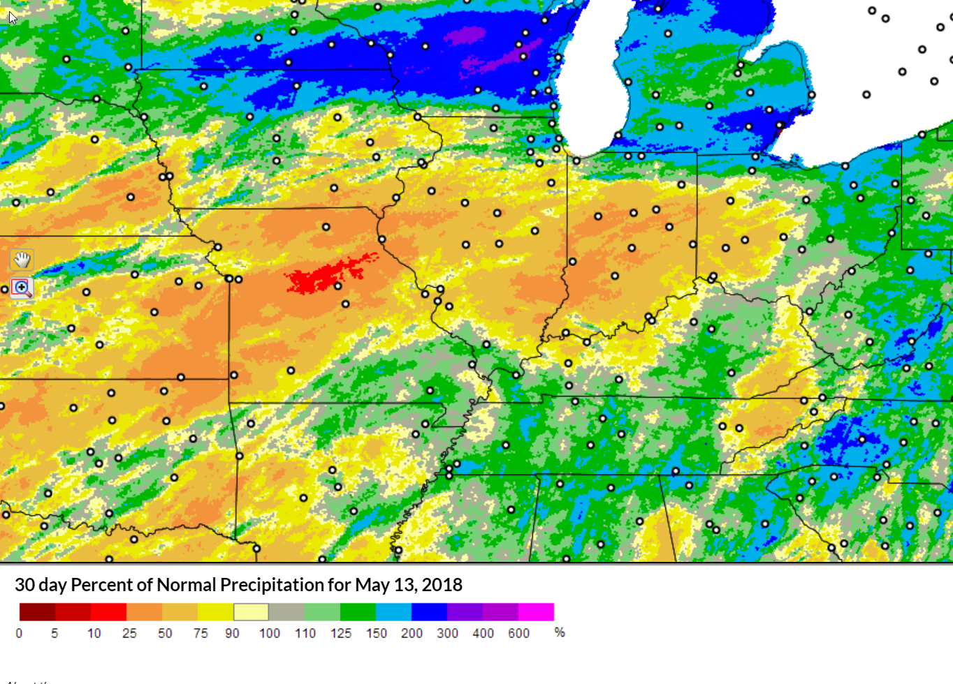
Precipitation over the last 90 days has mostly been above normal in our region. Over the last 30 days we have experienced some drying. The strong winds are also drying the surface of the ground quicker.
Here is the 90-day precipitation anomaly map
Here is the 30-day precipitation anomaly map
Notice the differences.
Today and Tuesday will continue the warm to hot theme. Numerous locations will top 90 degrees. It will feel humid, as well. Dew points will be well into the 60’s.
The good news is that there is some relief in sight. Unfortunately, it may come with a price.
A series of disturbances will push into our region over the coming week. This will increase our cloud cover and also increase our precipitation chances.
It is going to be difficult to forecast county to county. Often times, these types of patterns produce spotty showers and thunderstorms. One county receives heavy rain and another county receives very little rainfall.
There will be time periods when there will be an uptick in rain chances (see the daily outlook above).
Keep in mind, a 20% to 30% chance of showers and thunderstorms will mean someone will end up with rain. It just won’t be everyone.
Some of the storms, over the coming days, could produce heavy rain, frequent lightning, gusty winds, and dime to nickel size hail. The threat of an organized severe weather outbreak is low. If there were to be severe thunderstorms they would likely be isolated.
Temperatures will cool into the 80’s with the clouds and precipitation. It will likely remain somewhat humid.
This pattern may last right on through the upcoming weekend.
PWAT values will be high this week. That is an indicator of some heavy downpours, as well.
What are PWAT values?
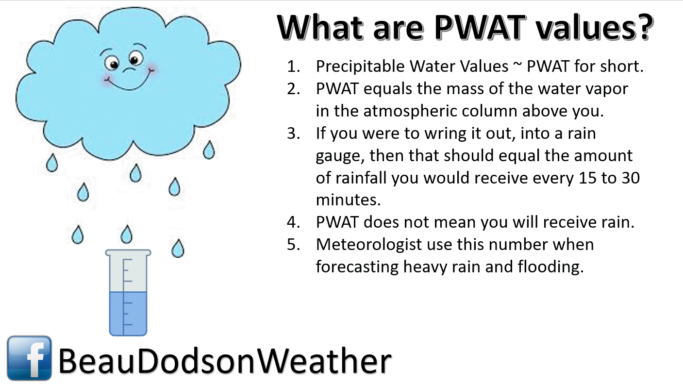
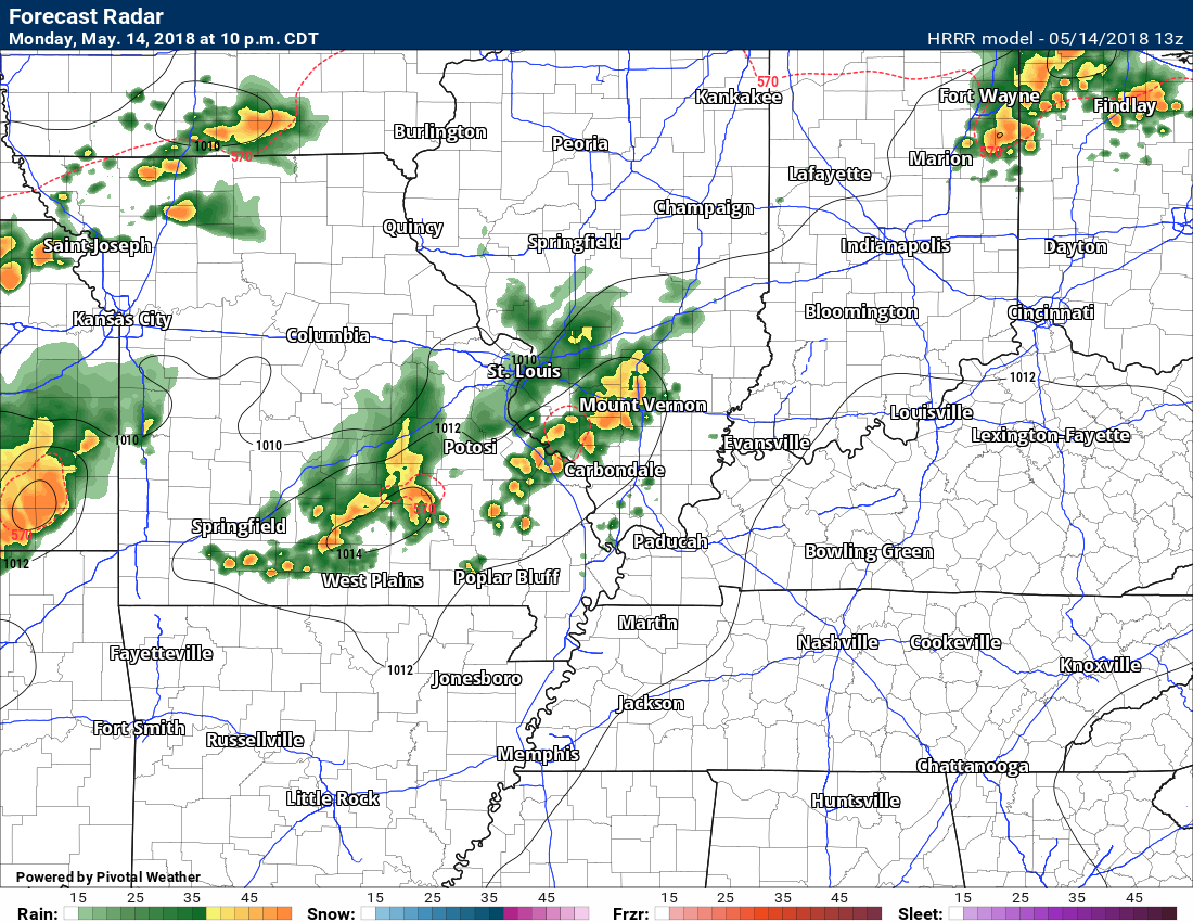
Here is the NAM model guidance PWAT value animation. You can see the high numbers hang around through the week.
The Hrrr model shows some thunderstorms tonight. We will see if it is on to something.
Tricky forecasting specific storms in this pattern.
9 PM Monday
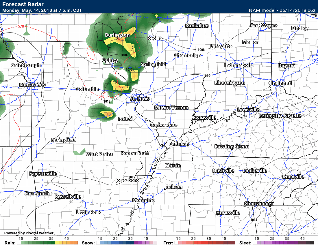
Here is the NAM future-cast radar.
Again, keep in mind, models don’t handle patterns like this all that well. Take the general idea from this graphic that there will be on and off shower and thunderstorm chances. Don’t take the specific. I doubt the model will be exactly right on when and where it will rain.
![]()

WeatherBrains Episode 642
Weather Brains is a weekly podcast/video for those who love weather and want more!
Our guest for this episode of WeatherBrains is Rudy Simoneaux. Rudy is the engineering manager of the Coastal Protection and Restoration Authority, along with being the project manager of the LSU Center for River Studies. He is also the president-elect of the Louisiana Section of the American Society of Civil Engineers.
Other discussions in this weekly podcast include topics like:
- Extremes: 108 at Death Valley, CA, and 20 at Bodie State Park, CA
- SPC Day 3 Slight Risk in Central US
- Hot from SW AZ to Texas
- Oklahoma had their first tornado of 2018 last week
- Astronomy Outlook with Tony Rice
- and more!
Our email bag officer is handling the incoming messages from our listeners. And we love to get them.
Previous episodes can be viewed by clicking here.

We offer interactive local city live radars and regional radars. If a radar does not update then try another one. If a radar does not appear to be refreshing then hit Ctrl F5. You may also try restarting your browser.
The local city view radars also have clickable warnings.
During the winter months, you can track snow and ice by clicking the winterize button on the local city view interactive radars.
You may email me at beaudodson@usawx.com
Find me on Facebook!

Find me on Twitter!

Did you know that a portion of your monthly subscription helps support local charity projects?
You can learn more about those projects by visiting the Shadow Angel Foundation website and the Beau Dodson News website.

I encourage subscribers to use the app vs regular text messaging. We have found text messaging to be delayed during severe weather. The app typically will receive the messages instantly. I recommend people have three to four methods of receiving their severe weather information.
Remember, my app and text alerts are hand typed and not computer generated. You are being given personal attention during significant weather events.
