Update
.
Today is a travel day for me.
Wow, what a terrible temperature forecast today for some of you. There was more sun anticipated across our southern counties.
That is what happens when I travel. The mice will play when the cat is away! I guess the weather decided to go rouge.
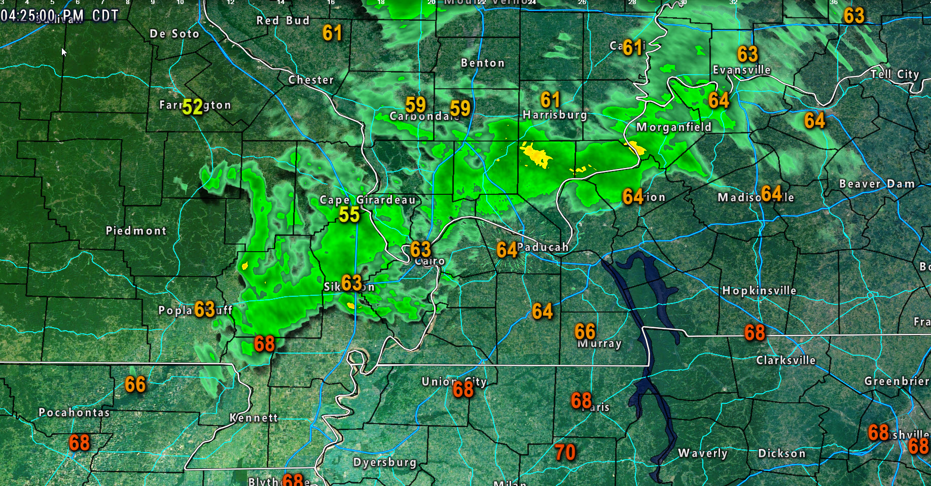
Here was the 4 PM temperature map. Some of you hit 70 degrees. That was not my forecast! Sorry about that.
I suppose nobody is complaining about it being warmer. Seems we can’t buy many warm days this winter errr I mean spring.
.
.
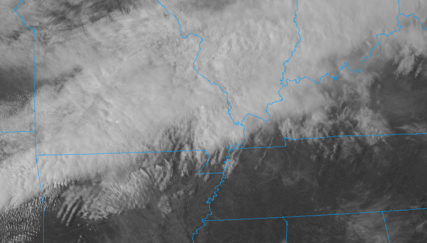
and satellite (notice the sun over our southern counties)
.
.
Rain continues to develop in the region. Rain will increase tonight over the southern half of our region. Some thunder possible. No severe weather. Gusty winds and falling temperatures.
Everyone will be in the 30’s and 40’s by morning. Chilly temperatures. Above freezing.
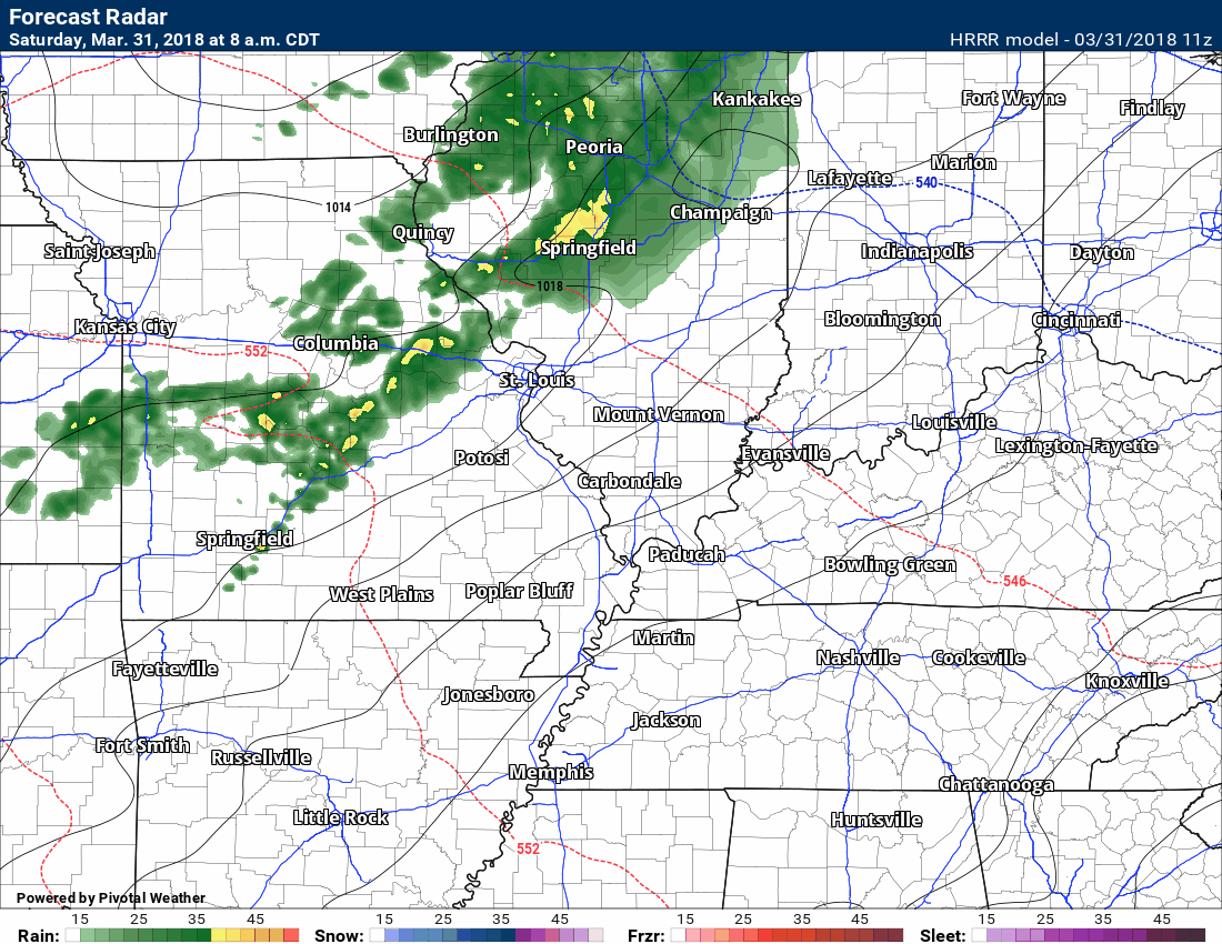
Here is the future-cast radar from the Hrrr model guidance. This is what radar may look like tonight.
Timestamp upper left.
.

.
Tomorrow’s forecast is complicated.
There is lower than normal confidence as to whether portions of the region receive a wintry mix late in the day into Sunday night.
I am certain that it will be colder. Area-wide temperatures will likely remain in the upper 30’s to middle 40’s. Some upper 40’s possible from the Bootheel of Missouri and then eastward along the Kentucky and Tennessee State line.
Winds will gust out of the north and northeast at 7 to 14 mph with gusts to 20 mph.
Early in the day, there might be some sun from Bollinger County, Missouri, towards Vienna, Illinois, and then towards Owensboro, Kentucky. Perhaps a mix of sun and clouds.
The clouds will rapidly thicken during the afternoon area-wide.
Precipitation is forecast to break out late in the afternoon across southeast Missouri and southern Illinois. Precipitation will increase in coverage and intensity as we move towards evening and into Sunday night.
A wintry mix is possible over our northern counties. That would most likely be from Perry County, Missouri, towards Jackson, Williamson, Saline, and Gallatin Counties in Illinois. From there northward there could be a rain, snow, and sleet mixture.
At this time, it appears accumulation would be light. There could be a period of heavy precipitation. Perhaps some light accumulation on grassy surfaces and elevated surfaces.
If there is a period of heavier sleet and snow then the chances for brief accumulation increases. This will need to be monitored Sunday evening and night.
We will need to monitor the freezing drizzle potential late Sunday night. That would mainly be our northern counties, as well.
Elsewhere, widespread rain is likely late Sunday afternoon into Sunday night.
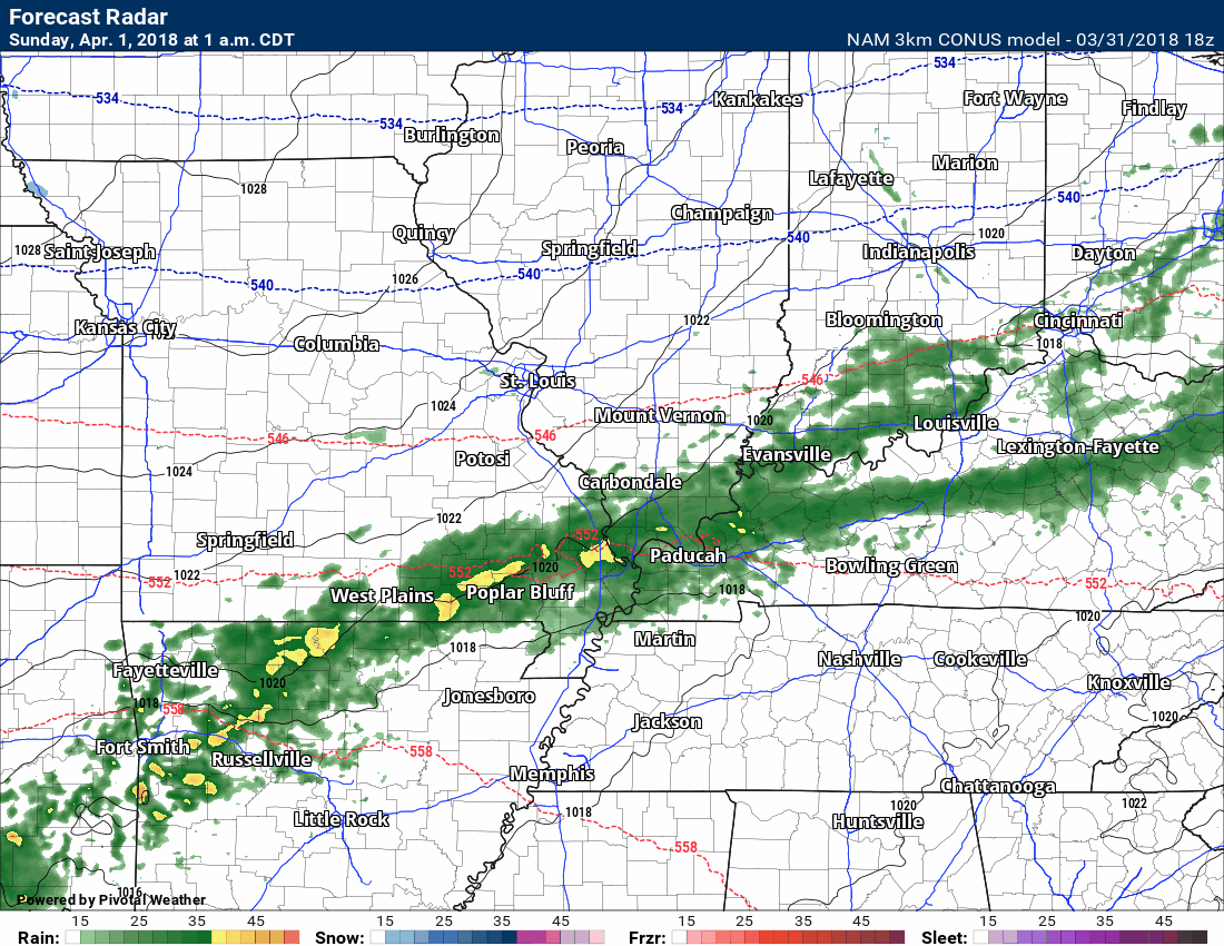
Here is the high resolution NAM model guidance. This is the future-cast radar. Green is rain. Yellow is moderate rain. Blue is snow. Purple and red would be a wintry mix.
Low confidence on the exact placement of the wintry mix late Sunday afternoon and into Sunday night.
Timestamp upper left.
.
.
Temperatures Sunday night will likely be in the 30’s area-wide. I can’t rule out upper 20’s near Mt. Vernon. Again, we might need to monitor the freezing drizzle potential in areas where temperatures fall below freezing. Bridges and elevated surfaces would be the concern.
Temperatures Monday and Tuesday will warm a bit. That will be followed by colder weather Wednesday into Thursday. It appears we may have frost or freeze conditions those nights.
Highs Monday will be in the 50’s. You can expect 60’s on Tuesday. You can expect 40’s and 50’s on Wednesday and Thursday.
Lows Tuesday night will likely dip into the 30’s. Wednesday night temperatures will range from 28 to 34. Temperatures Thursday night will likely remain in the upper 30’s to lower 40’s.
Rain chances increase Monday into Tuesday night. Chances on Monday will likely remain below 40%. Chances Monday night will increase to 40% from Poplar Bluff, Missouri, towards Paducah, Kentucky, and then towards Madisonville, Kentucky. North of there the shower and thunderstorm chances will ramp up to 60%. Chances Tuesday into Tuesday night will increase to 80%. Some strong/severe storms are possible Tuesday/Tuesday night.
Let’s keep an eye on Tuesday and Tuesday night. A strong cold front will move into the region. Wind shear will be strong. We will have some instability. Thunderstorms could roduce damaging winds and hail. We will need to monitor the tornado risk, as well. Stay tuned.
.
Saturday, March 31, 2018
.
.
NAM future-cast radar
.
.
NAM future-cast temperatures
.

.
Hrrr model (another model) future-cast radar
.
.

WWW.WEATHERTALK.COM subscribers, here is my day to day schedule for your weather products.


Interactive Radars:
Interactive live weather radar page. Choose the city nearest your location. If one of the cities does not work then try a nearby one. Click here.
March 31, 2018
Saturday Forecast Details
Forecast: Strong and gusty winds. A mix of sun and clouds early and then becoming cloudy. Showers developing from the northwest to the southeast. Arriving in the Farmington, Missouri area between 10 AM and 12 PM. The line will then push southeast. Metropolis/Paducah area around 2 PM to 4 PM. It will then continue to push southeast.
Temperatures: MO ~ 58 to 64 IL ~ 56 to 62 KY ~ 58 to 64 TN ~ 60 to 65
What is the chance of precipitation? MO ~ 60% IL ~ 60% KY ~ 60% TN ~ 60%
Coverage of precipitation: A band of numerous showers and isolated thunderstorms will push northwest to southeast during the late morning into the afternoon hours.
Winds: South winds becoming southwest at 15 to 30 mph and gusty.
What impacts are anticipated from the weather? Wet roadways. Isolated lightning. Gusty winds.
My confidence in the forecast verifying: High
Is severe weather expected? No
The NWS defines severe weather as 58 mph wind or great, 1″ hail or larger, and/or tornadoes
Should I cancel my outdoor plans? Have a plan B and monitor radars. It likely won’t rain all day.
Sunrise 6:41 AM
Saturday Night Forecast Details:
Forecast: Mostly cloudy. Rain showers likely, especially early. Chilly temperatures. A slight chance the rain will mix with snow over our northern counties. No accumulation.
Temperatures: MO ~ 32 to 35 IL ~ 32 to 35 KY ~ 36 to 42 TN ~ 38 to 44
What is the chance of precipitation? MO ~ 60% IL ~ 60% KY ~ 60% TN ~ 60%
Coverage of precipitation: Scattered to perhaps a period of widespread rain early
Winds: South winds becoming southwest and eventually north/northwest at 7 to 14 mph
What impacts are anticipated from the weather? Wet roadways.
My confidence in the forecast verifying: High
Is severe weather expected? No
The NWS defines severe weather as 58 mph wind or great, 1″ hail or larger, and/or tornadoes
Should I cancel my outdoor plans? Have a plan B and monitor radars
Sunset 7:16 PM
April 1, 2018
Sunday Forecast Details
Easter
Forecast: Cloudy early. Rain may linger from the Bootheel towards the Kentucky/Tennessee border counties. Keep this in mind. Cloudy and chilly. Rain developing during the afternoon and evening hours. Rain may mix with or change to snow and sleet across portions of the area.
Temperatures: MO ~ 36 to 44 IL ~ 36 to 44 KY ~ 44 to 48 TN ~ 45 to 50
What is the chance of precipitation? MO ~ 30% morning and then 60% afternoon IL ~ 60% afternoon KY ~ 40% morning and then 60% afternoon TN ~ 50% morning and then 60% afternoon
Coverage of precipitation: Some rain possible from the Bootheel into the Kentucky/Tennessee border counties before 12 PM. Becoming widespread during the afternoon and evening.
Winds: North and northeast at 7 to 14 mph
What impacts are anticipated from the weather? Wet roadways. Monitor snow chances.
My confidence in the forecast verifying: Medium
Is severe weather expected? No
The NWS defines severe weather as 58 mph wind or great, 1″ hail or larger, and/or tornadoes
Should I cancel my outdoor plans? Monitor radars.
Sunrise 6:40 AM
Sunday Night Forecast Details:
Forecast: Scattered showers. Snow or wintry mix possible. Some of the guidance shows slushy accumulation across portions of southeast Missouri and southern Illinois. Monitor updates.
Temperatures: MO ~ 28 to 34 IL ~ 28 to 34 KY ~ 34 to 38 TN ~ 34 to 38
What is the chance of precipitation? MO ~ 60% IL ~ 70% KY ~ 70% TN ~ 70%
Coverage of precipitation: Widespread before 1 AM
Winds: North and northeast at 5 to 10 mph
What impacts are anticipated from the weather? Wet roadways. Monitor wintry mix/snow chances.
My confidence in the forecast verifying: Medium
Is severe weather expected? No
The NWS defines severe weather as 58 mph wind or great, 1″ hail or larger, and/or tornadoes
Should I cancel my outdoor plans? Monitor updates.
Sunset 7:16 PM
April 2, 2018
Monday Forecast Details
Forecast: A mix of sun and clouds. Milder. Early morning showers or rain/snow showers ending. Isolated showers the rest of the day. A thunderstorm possible.
Temperatures: MO ~ 54 to 58 IL ~ 52 to 56 KY ~ 55 to 60 TN ~ 56 to 62
What is the chance of precipitation? MO ~ 30% IL ~ 30% KY ~ 30% TN ~ 30%
Coverage of precipitation: Scattered
Winds: Northeast to east becoming east and southeast at 5 to 10 mph
What impacts are anticipated from the weather? Wet roadways. Lightning.
My confidence in the forecast verifying: Medium
Is severe weather expected? No
The NWS defines severe weather as 58 mph wind or great, 1″ hail or larger, and/or tornadoes
Should I cancel my outdoor plans? No, but monitor updates.
Sunrise 6:38 AM
Monday Night Forecast Details:
Forecast: Mostly cloudy. Showers and thunderstorms again possible. Not as cold.
Temperatures: MO ~ 48 to 54 IL ~ 46 to 50 KY ~ 50 to 55 TN ~ 50 to 55
What is the chance of precipitation? MO ~ 60% IL ~ 60% KY ~ 60% TN ~ 60%
Coverage of precipitation: Scattered. Some data shows widespread rain developing.
Winds: South at 6 to 12 mph with gusts to 18
What impacts are anticipated from the weather? Wet roadways. Lightning.
My confidence in the forecast verifying: LOW
Is severe weather expected? Monitor updates. A few strong storms possible Monday night and Tuesday.
The NWS defines severe weather as 58 mph wind or great, 1″ hail or larger, and/or tornadoes
Should I cancel my outdoor plans? No, but monitor updates.
Sunset 7:17 PM

Questions? Broken links? Other?
You may email me at beaudodson@usawx.com

The National Weather Service defines a severe thunderstorm as one that produces quarter size hail or larger, 58 mph winds or greater, and/or a tornado.
Friday through Tuesday:
Severe weather is not anticipated. Lightning is possible Monday into Tuesday. Strong storms possible Monday night/Tuesday.
I am monitoring the risk of severe weather Tuesday.
![]()
Interactive live weather radar page. Choose the city nearest your location. If one of the cities does not work then try a nearby one. Click here.
National map of weather watches and warnings. Click here.
Storm Prediction Center. Click here.
Weather Prediction Center. Click here.

Live lightning data: Click here.

Interactive GOES R satellite. Track clouds. Click here.

Here are the latest local river stage forecast numbers Click Here.
Here are the latest lake stage forecast numbers for Kentucky Lake and Lake Barkley Click Here.

The spring and preliminary summer outlooks have been posted for subscribers. Scroll down to see the outlook.
Not a subscriber? Learn more at this link.