
Click one of the links below to take you directly to that section
![]()
![]()
![]()
![]()
![]()
![]()
![]()
.

.
Seven Day Hazardous Weather Outlook
1. Is lightning in the forecast? YES. Northern counties will have a chance tonight into Tuesday. The rest of the region will be monitoring Sunday into Tuesday. Focused on Monday/Tuesday.
2. Are severe thunderstorms in the forecast? MONITOR. I am watching Sunday into Tuesday. Some of the thunderstorms could be intense. See the severe weather outlooks in the discussion portion of this web post.
3. Is flash flooding in the forecast? MONITOR. Any slow moving thunderstorms this weekend into next week could cause locally heavy rain. We will need to monitor the setup.
4. Will non-thunderstorm winds top 40 mph? NOT AT THIS TIME. Gusty winds are possible Sunday into Tuesday. For now, I kept them below 40 mph.
5. Will the heat index exceed 100 degrees? NO.
6. Will the wind chill dip below 10 degrees? NO.
7. Is measurable snow and/or sleet in the forecast? NO.
8. Is freezing rain/ice in the forecast? NO.
Freezing rain is rain that falls and instantly freezes on objects such as trees and power lines Freezing fog possible, as well.
.

Fire weather risk level.
Friday through Friday night: 5. Medium risk.
Saturday: 4. Low risk.
Saturday night: 3. Very low risk.
Fire Weather Discussion
Today will feature increasing southwesterly winds which will be strongest across southeast Missouri and southern Illinois. These areas will also experience an uptick in humidity levels though with RH values remaining above 30 percent. Meanwhile, winds won`t be as strong across west Kentucky, but RH values will once again drop into the 20 to 25 percent range. This will lead to an elevated fire weather concern with the ongoing dry fuels. Humidity levels rise across the entire area over the weekend as decent southwesterly winds continue with good dispersion expected through Sunday. Small rain chances exist tonight and over the weekend for parts of the area, but the best chance for wetting rains holds off until Monday evening and night when a cold front approaches the region.
A Haines Index of 6 means a high potential for an existing fire to become large or exhibit erratic fire behavior, 5 means medium potential, 4 means low potential, and anything less than 4 means very low potential.
.

THE FORECAST IS GOING TO VARY FROM LOCATION TO LOCATION.
Scroll down to see your local forecast details.
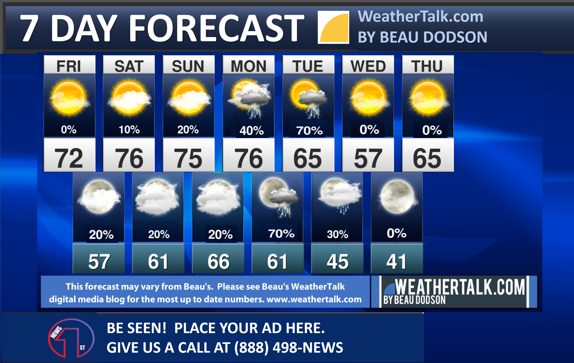
Seven-day forecast for southeast Missouri, southern Illinois, western Kentucky, and western Tennessee.
This is a BLEND for the region. Scroll down to see the region by region forecast.
48-hour forecast Graphics


.
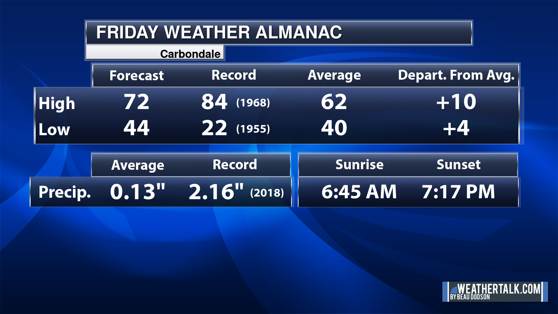
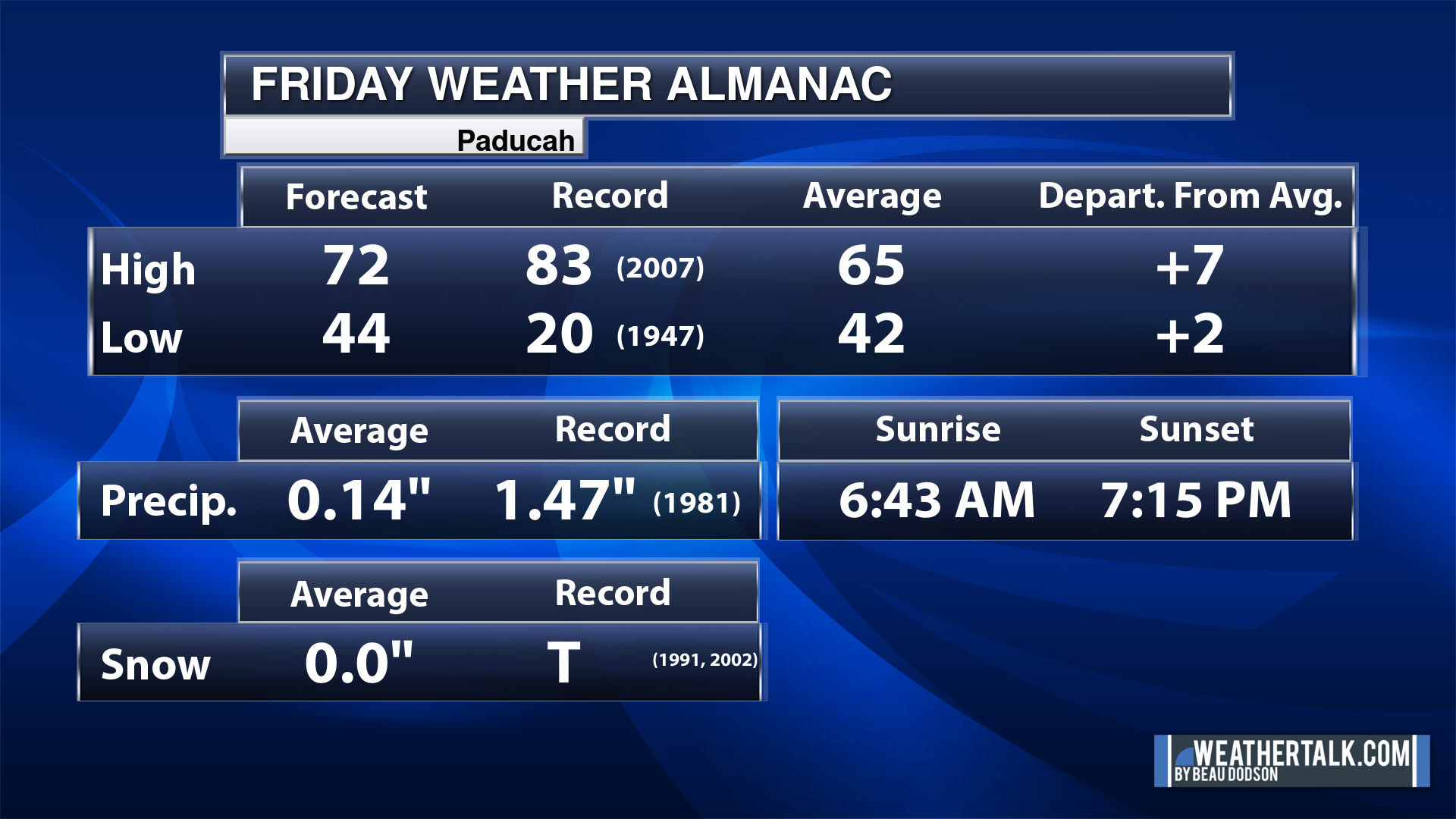
Today’s Local Almanacs (for a few select cities). Your location will be comparable.
Note, the low is this morning’s low and not tomorrows.
The forecast temperature shows you today’s expected high and this morning’s low.
The graphic shows you the record high and record low for today. It shows you what year that occurred, as well.
It then shows you what today’s average temperature is.
It shows you the departures (how may degrees above or below average temperatures will be ).
It shows you the average precipitation for today. Average comes from thirty years of rain totals.
It also shows you the record rainfall for the date and what year that occurred.
The sunrise and sunset are also shown.


![]()
.
.
Friday Forecast: Mostly sunny.
What is the chance of precipitation?
Far northern southeast Missouri ~ 0%
Southeast Missouri ~ 0%
The Missouri Bootheel ~ 0%
I-64 Corridor of southern Illinois ~ 0%
Southern Illinois ~ 0%
Extreme southern Illinois (southern seven counties) ~ 0%
Far western Kentucky (Purchase area) ~ 0%
The Pennyrile area of western KY ~ 0%
Northwest Kentucky (near Indiana border) ~ 0%
Northwest Tennessee ~ 0%
Coverage of precipitation:
Timing of the precipitation:
Far northern southeast Missouri ~ 70° to 74°
Southeast Missouri ~ 70° to 74°
The Missouri Bootheel ~ 70° to 74°
I-64 Corridor of southern Illinois ~ 68° to 72°
Southern Illinois ~ 68° to 72°
Extreme southern Illinois (southern seven counties) ~ 68° to 72°
Far western Kentucky ~ 70° to 74°
The Pennyrile area of western KY ~ 70° to 72°
Northwest Kentucky (near Indiana border) ~ 68° to 72°
Northwest Tennessee ~ 70° to 74°
Winds will be from this direction: South southwest 10 to 20 mph. Gusty.
Wind chill or heat index (feels like) temperature forecast: 68° to 74°
What impacts are anticipated from the weather?
Should I cancel my outdoor plans? No
UV Index: 7. High.
Sunrise: 6:45 AM
Sunset: 7:16 PM
.
Friday Night Forecast: Partly cloudy. A chance of thunderstorms over our far northern counties.
Here is a graphic shows you where a few storms could occur tonight. The chances are fairly low, but not zero.
What is the chance of precipitation?
Far northern southeast Missouri ~ 20%
Southeast Missouri ~ 20%
The Missouri Bootheel ~ 0%
I-64 Corridor of southern Illinois ~ 20%
Southern Illinois ~ 20%
Extreme southern Illinois (southern seven counties) ~ 10%
Far western Kentucky (Purchase area) ~ 0%
The Pennyrile area of western KY ~ 0%
Northwest Kentucky (near Indiana border) ~ 20%
Northwest Tennessee ~ 0%
Coverage of precipitation: Widely scattered
Timing of the precipitation: After 9 PM
Temperature range:
Far northern southeast Missouri ~ 52° to 55°
Southeast Missouri ~ 52° to 55°
The Missouri Bootheel ~ 53° to 56°
I-64 Corridor of southern Illinois ~ 52° to 55°
Southern Illinois ~ 52° to 55°
Extreme southern Illinois (southern seven counties) ~ 52° to 55°
Far western Kentucky ~ 52° to 55°
The Pennyrile area of western KY ~ 52° to 55°
Northwest Kentucky (near Indiana border) ~ 52° to 55°
Northwest Tennessee ~ 53° to 56°
Winds will be from this direction: South southwest 15 to 30 mph.
Wind chill or heat index (feels like) temperature forecast: 46° to 54°
What impacts are anticipated from the weather? Wet roadways. Lightning.
Should I cancel my outdoor plans? No, but check the Beau Dodson Weather Radars
Moonrise: 11:55 PM
Moonset: 8:45 AM
The phase of the moon: Waning Gibbous
.
Saturday Forecast: Partly sunny. A chance of a shower or thunderstorm far north.
Here is the place of the shower and thunderstorm chances. The chances are low, but not zero.
What is the chance of precipitation?
Far northern southeast Missouri ~ 20%
Southeast Missouri ~ 10%
The Missouri Bootheel ~ 0%
I-64 Corridor of southern Illinois ~ 20%
Southern Illinois ~ 20%
Extreme southern Illinois (southern seven counties) ~ 0%
Far western Kentucky (Purchase area) ~ 0%
The Pennyrile area of western KY ~ 0%
Northwest Kentucky (near Indiana border) ~ 20%
Northwest Tennessee ~ 0%
Coverage of precipitation: Isolated
Timing of the precipitation: After 12 PM
Far northern southeast Missouri ~ 72° to 75°
Southeast Missouri ~ 72° to 75°
The Missouri Bootheel ~ 74° to 76°
I-64 Corridor of southern Illinois ~ 72° to 75°
Southern Illinois ~ 73° to 76°
Extreme southern Illinois (southern seven counties) ~ 73° to 76°
Far western Kentucky ~ 73° to 76°
The Pennyrile area of western KY ~ 73° to 76°
Northwest Kentucky (near Indiana border) ~ 72° to 75°
Northwest Tennessee ~ 74° to 76°
Winds will be from this direction: South southwest 10 to 30 mph. Gusty.
Wind chill or heat index (feels like) temperature forecast: 70° to 75°
What impacts are anticipated from the weather? Wet roadways. Lightning.
Should I cancel my outdoor plans? No, but check the Beau Dodson Weather Radars
UV Index: 7. High.
Sunrise: 6:43 AM
Sunset: 7:16 PM
.
Saturday Night Forecast: Partly cloudy. A chance of thunderstorms over our far northern counties.
Here are the rain chances. They are low, but not zero.
What is the chance of precipitation?
Far northern southeast Missouri ~ 20%
Southeast Missouri ~ 20%
The Missouri Bootheel ~ 0%
I-64 Corridor of southern Illinois ~ 20%
Southern Illinois ~ 20%
Extreme southern Illinois (southern seven counties) ~ 10%
Far western Kentucky (Purchase area) ~ 0%
The Pennyrile area of western KY ~ 0%
Northwest Kentucky (near Indiana border) ~ 20%
Northwest Tennessee ~ 0%
Coverage of precipitation: Widely scattered
Timing of the precipitation: Any given point of time (far north)
Temperature range:
Far northern southeast Missouri ~ 52° to 55°
Southeast Missouri ~ 52° to 55°
The Missouri Bootheel ~ 54° to 58°
I-64 Corridor of southern Illinois ~ 52° to 55°
Southern Illinois ~ 52° to 55°
Extreme southern Illinois (southern seven counties) ~ 54° to 56°
Far western Kentucky ~ 54° to 58°
The Pennyrile area of western KY ~ 54° to 58°
Northwest Kentucky (near Indiana border) ~ 52° to 55°
Northwest Tennessee ~ 54° to 58°
Winds will be from this direction: South southwest 15 to 30 mph.
Wind chill or heat index (feels like) temperature forecast: 50° to 56°
What impacts are anticipated from the weather? Wet roadways. Lightning.
Should I cancel my outdoor plans? No, but check the Beau Dodson Weather Radars
Moonrise:
Moonset: 9:22 AM
The phase of the moon: Waning Gibbous
.
Sunday Forecast: Partly sunny. A chance of showers and thunderstorms
Here are the rain probabilities. You can see that they are focused north vs south.
What is the chance of precipitation?
Far northern southeast Missouri ~ 40%
Southeast Missouri ~ 20%
The Missouri Bootheel ~ 10%
I-64 Corridor of southern Illinois ~ 40%
Southern Illinois ~ 30%
Extreme southern Illinois (southern seven counties) ~ 20%
Far western Kentucky (Purchase area) ~ 20%
The Pennyrile area of western KY ~ 10%
Northwest Kentucky (near Indiana border) ~ 30%
Northwest Tennessee ~ 10%
Coverage of precipitation: Scattered
Timing of the precipitation: Any given point of time
Far northern southeast Missouri ~ 74° to 78°
Southeast Missouri ~ 74° to 78°
The Missouri Bootheel ~ 74° to 78°
I-64 Corridor of southern Illinois ~ 74° to 78°
Southern Illinois ~ 74° to 78°
Extreme southern Illinois (southern seven counties) ~ 74° to 78°
Far western Kentucky ~ 74° to 78°
The Pennyrile area of western KY ~ 74° to 78°
Northwest Kentucky (near Indiana border) ~ 74° to 78°
Northwest Tennessee ~ 74° to 78°
Winds will be from this direction: South 10 to 30 mph. Gusty.
Wind chill or heat index (feels like) temperature forecast: 72° to 80°
What impacts are anticipated from the weather? Wet roadways. Lightning. Some storms could produce wind and hail.
Should I cancel my outdoor plans? No, but check the Beau Dodson Weather Radars
UV Index: 4. Moderate
Sunrise: 6:42 AM
Sunset: 7:17 PM
.
Sunday Night Forecast: Partly cloudy. A chance of thunderstorms over our far northern counties.
Here are the rain probabilities. Once again, the probabilities are higher farther north vs south.
What is the chance of precipitation?
Far northern southeast Missouri ~ 30%
Southeast Missouri ~ 30%
The Missouri Bootheel ~ 10%
I-64 Corridor of southern Illinois ~ 30%
Southern Illinois ~ 30%
Extreme southern Illinois (southern seven counties) ~ 20%
Far western Kentucky (Purchase area) ~ 20%
The Pennyrile area of western KY ~ 10%
Northwest Kentucky (near Indiana border) ~ 30%
Northwest Tennessee ~ 10%
Coverage of precipitation: Scattered
Timing of the precipitation: Any given point of time
Temperature range:
Far northern southeast Missouri ~ 58° to 62°
Southeast Missouri ~ 60° to 64°
The Missouri Bootheel ~ 60° to 64°
I-64 Corridor of southern Illinois ~ 58° to 62°
Southern Illinois ~ 58° to 62°
Extreme southern Illinois (southern seven counties) ~ 60° to 64°
Far western Kentucky ~ 60° to 64°
The Pennyrile area of western KY ~ 60° to 64°
Northwest Kentucky (near Indiana border) ~ 58° to 62°
Northwest Tennessee ~ 60° to 64°
Winds will be from this direction: South southwest 15 to 30 mph.
Wind chill or heat index (feels like) temperature forecast: 58° to 64°
What impacts are anticipated from the weather? Wet roadways. Lightning. Some storms could produce wind and hail.
Should I cancel my outdoor plans? No, but check the Beau Dodson Weather Radars
Moonrise: 12:59 AM
Moonset: 10:08 AM
The phase of the moon: Waning Gibbous
.
Monday Forecast: Mostly cloudy. A chance of showers and thunderstorms.
What is the chance of precipitation?
Far northern southeast Missouri ~ 70%
Southeast Missouri ~ 60%
The Missouri Bootheel ~ 60%
I-64 Corridor of southern Illinois ~ 60%
Southern Illinois ~ 60%
Extreme southern Illinois (southern seven counties) ~ 60%
Far western Kentucky (Purchase area) ~ 40%
The Pennyrile area of western KY ~ 40%
Northwest Kentucky (near Indiana border) ~ 40%
Northwest Tennessee ~ 40%
Coverage of precipitation: Scattered
Timing of the precipitation: Any given point of time
Far northern southeast Missouri ~ 74° to 78°
Southeast Missouri ~ 74° to 78°
The Missouri Bootheel ~ 74° to 78°
I-64 Corridor of southern Illinois ~ 74° to 78°
Southern Illinois ~ 74° to 78°
Extreme southern Illinois (southern seven counties) ~ 74° to 78°
Far western Kentucky ~ 74° to 78°
The Pennyrile area of western KY ~ 74° to 78°
Northwest Kentucky (near Indiana border) ~ 74° to 78°
Northwest Tennessee ~ 74° to 78°
Winds will be from this direction: South 10 to 30 mph. Gusty.
Wind chill or heat index (feels like) temperature forecast: 72° to 80°
What impacts are anticipated from the weather? Wet roadways. Lightning. Some storms could produce wind and hail.
Should I cancel my outdoor plans? No, but check the Beau Dodson Weather Radars
UV Index: 4. Moderate
Sunrise: 6:40 AM
Sunset: 7:18 PM
.
Monday Night Forecast: Mostly cloudy. Showers and thunderstorms.
What is the chance of precipitation?
Far northern southeast Missouri ~ 80%
Southeast Missouri ~ 80%
The Missouri Bootheel ~ 80%
I-64 Corridor of southern Illinois ~ 80%
Southern Illinois ~ 80%
Extreme southern Illinois (southern seven counties) ~ 80%
Far western Kentucky (Purchase area) ~ 80%
The Pennyrile area of western KY ~ 70%
Northwest Kentucky (near Indiana border) ~ 70%
Northwest Tennessee ~ 80%
Coverage of precipitation: Numerous
Timing of the precipitation: Any given point of time
Temperature range:
Far northern southeast Missouri ~ 54° to 58°
Southeast Missouri ~ 54° to 58°
The Missouri Bootheel ~ 54° to 58°
I-64 Corridor of southern Illinois ~ 54° to 58°
Southern Illinois ~ 54° to 58°
Extreme southern Illinois (southern seven counties) ~ 54° to 58°
Far western Kentucky ~ 54° to 58°
The Pennyrile area of western KY ~ 54° to 58°
Northwest Kentucky (near Indiana border) ~ 54° to 58°
Northwest Tennessee ~ 54° to 58°
Winds will be from this direction: South southwest 15 to 35 mph.
Wind chill or heat index (feels like) temperature forecast: 54° to 58°
What impacts are anticipated from the weather? Wet roadways. Lightning. Some storms could produce wind and hail.
Should I cancel my outdoor plans? Have a plan B and monitor updates. Monitor the Beau Dodson Weather Radars.
Moonrise: 2:10 AM
Moonset: 11:04 AM
The phase of the moon: Last Quarter
.
Click here if you would like to return to the top of the page.

-
- Warmer weather for Easter weekend.
- Monitoring shower and thunderstorm chances over our northern counties Friday night into Saturday night.
- Monitoring thunderstorm chances across more of the area Sunday into Tuesday.
- Will need to monitor the end time of thunderstorms next week. Some data continues chances into Wednesday. Uncertainty.
Weather advice:
Do you have any suggestions or comments? Email me at beaudodson@usawx.com
Make sure you have three to five ways of receiving your severe weather information.
.
Beau’s Forecast Discussion
Happy Easter weekend, everyone. I hope you and your family have a nice weekend. It is going to feel like spring.
One of the warmest Easter’s in a while. Widespread 70s this weekend and some 80s not out of the question. Either way, nice.
Now, we have to deal with a frontal boundary to the north of us. This will bring occasional showers and thunderstorms. See the top of the page for the rain probabilities.
They are low, but not zero. I suspect there will be some activity, from time to time, on radar.
A bit breezy at times today into Tuesday, as well. Kite flying weather? Perhaps!
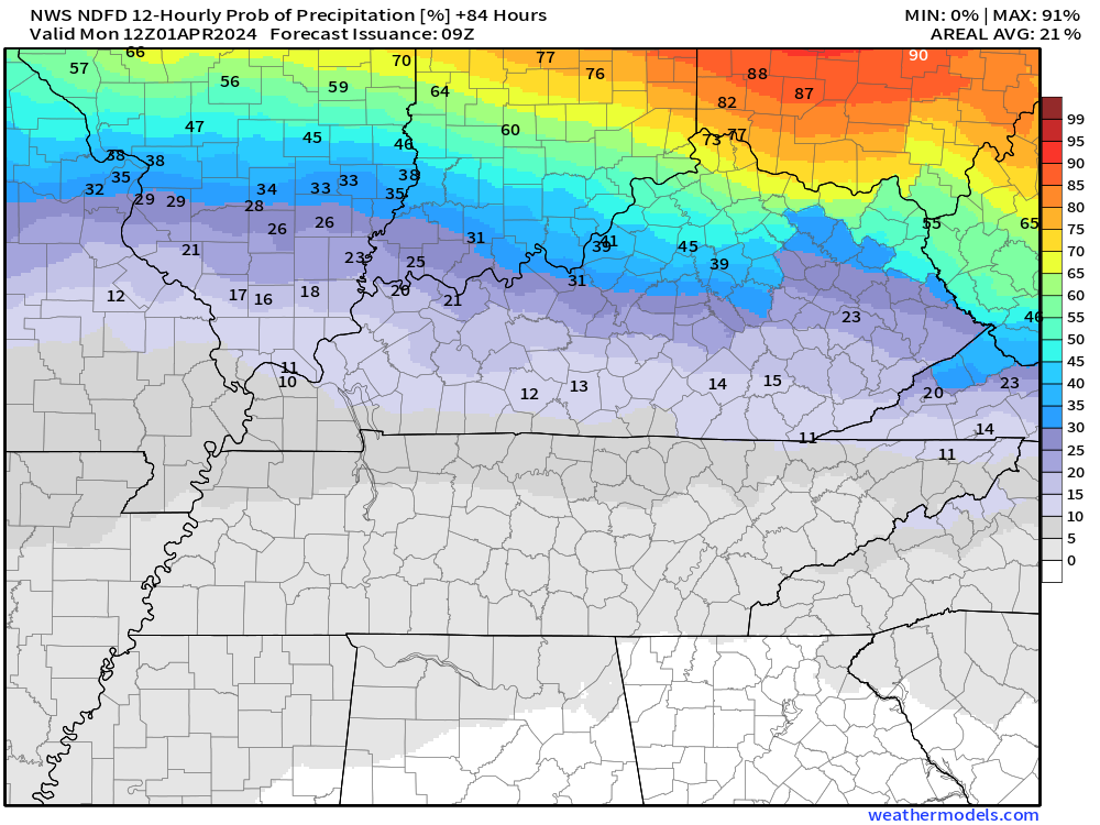
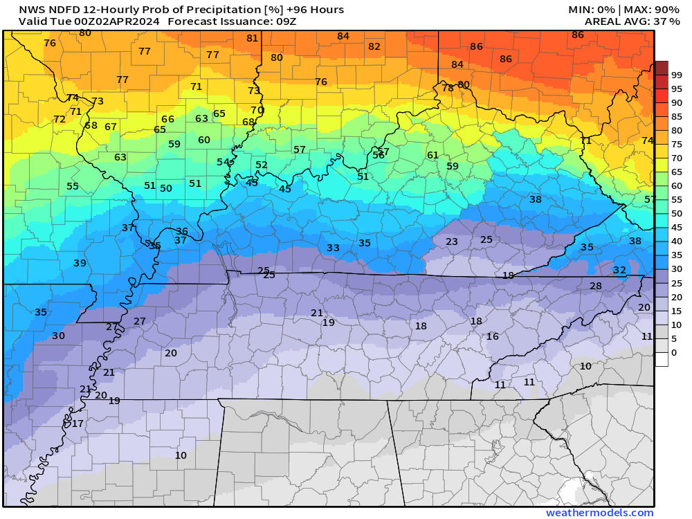
I did post the rain probability maps at the top of the page. Those numbers dramatically increase Monday into Tuesday.
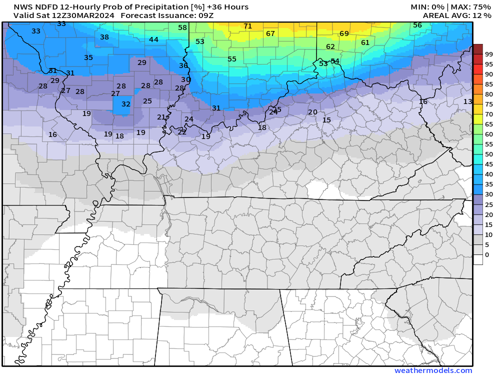
Let’s look at those numbers.
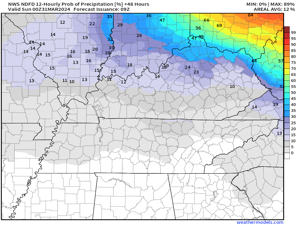
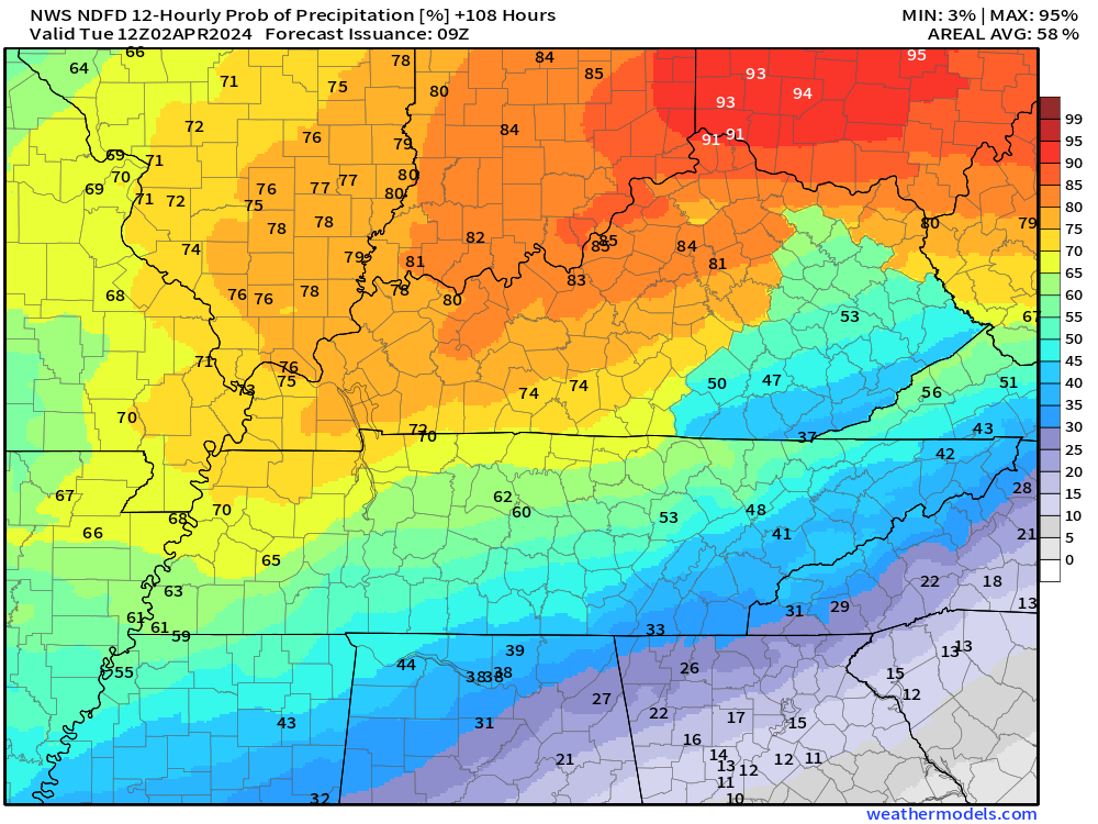
The cold front sweeps across the region Monday night and Tuesday morning and this will bring peak rain chances. Thunderstorms, as well.
Rain chances during the day Monday. Higher chances north vs south, again.
Here are the Monday night rain probabilities. As you can see, they peak as the front moves through the region.
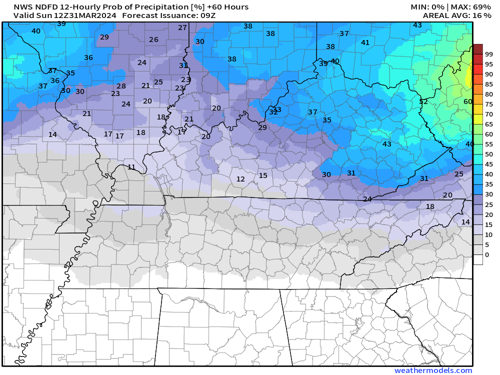
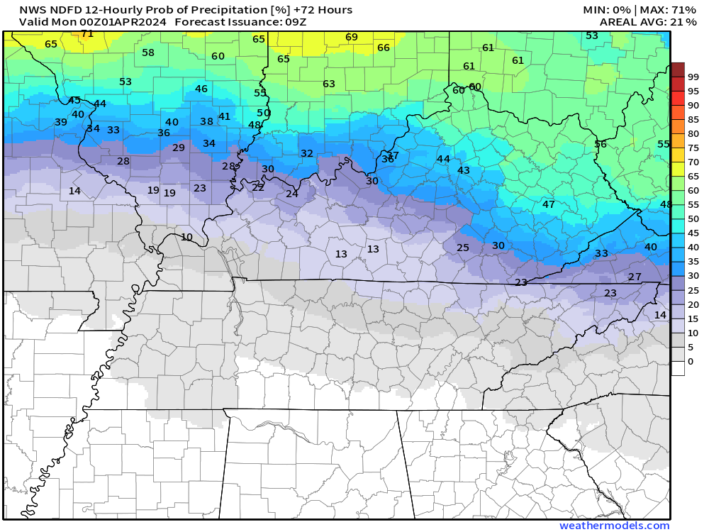
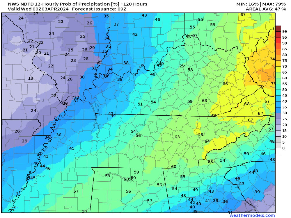
Rain tapers off from west to east Tuesday afternoon and evening. Here are the rain probabilities Tuesday.
Severe weather remains a question. There are signals for at least some risk, but the signal is higher to our north and west. That leaves some questions about our area and this means we will need to monitor updated forecasts.
Don’t walk away with one forecast and assume that will be the final solution. These events are still several days away.
The Storm Prediction Center has drawn an area of showers and thunderstorms Friday night into Saturday morning
It is possible a couple of showers or storms will be far enough south to impact northern portions of southeast Missouri and northern portions of southern Illinois.
The green zone is where they currently show the possibility of lightning. Severe thunderstorms are not expected today or tonight.
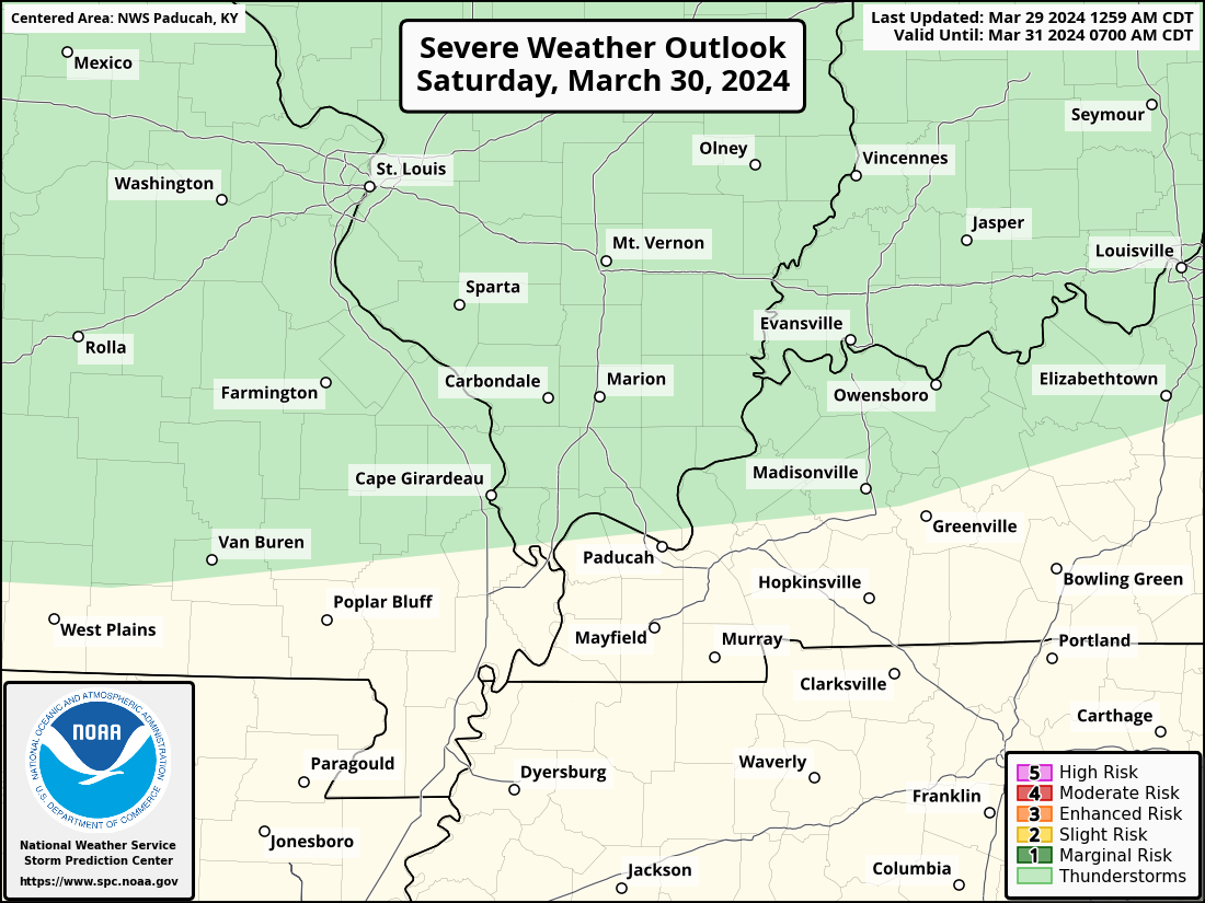
Sunday’s severe weather outlook. Some of these storms, in the dark green zone, could be severe with large hail and gusty winds.
I am watching for a few supercells over Missouri and Illinois. Again, hail will be the concern.
The green zone is where lightning will be possible. The dark green zone is where a few storms could become severe. For now, this is north of my area.
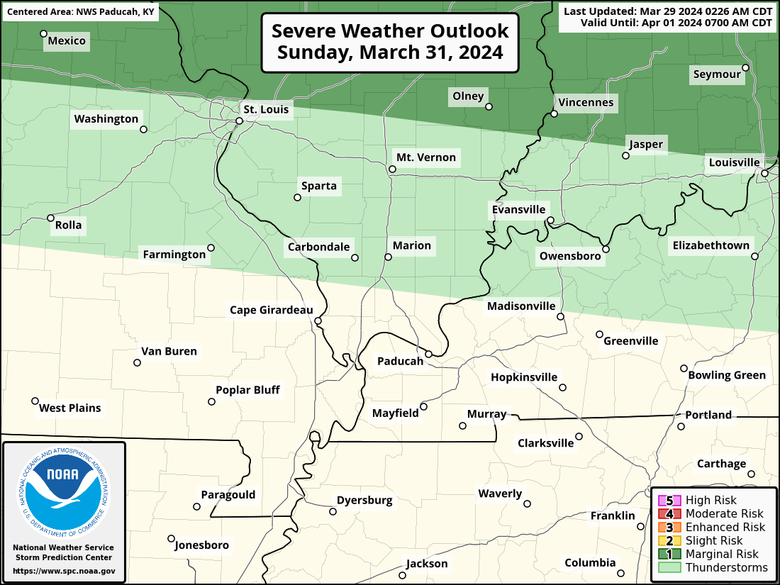
Showers and thunderstorms become more numerous Sunday night into Tuesday. Here is the severe weather outlook for Monday and Monday night. We will need to keep an eye on this.
The orange zone is a higher risk of severe weather. The yellow zone is a level two risk zone for severe thunderstorms. This does include portions of our region.
Damaging wind, hail, and tornadoes will be possible in both zones. The risk is a bit higher over the orange zone. This could shift around, so let’s monitor updates over the next few days. The event is still several days away.
The primary concern locally would likely hold off until Monday afternoon and night.
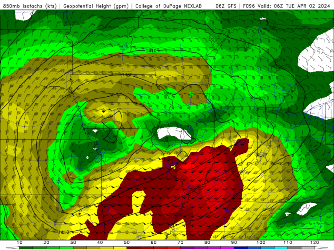
850 mb wind speeds do pick up Monday afternoon and night. That is quite a bit of wind shear. Wind shear is the turning of wind direction with height and wind speed change with height.
There are decent winds several thousand feet aloft.
Monday around 10 pm.
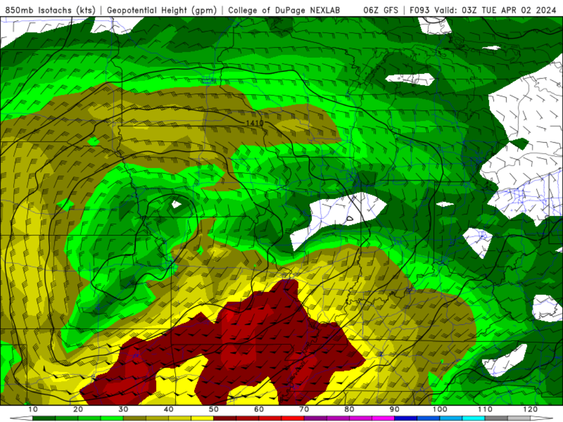
Wind speeds around 3 am. That red is high winds aloft. That is an ingredient for severe storms.
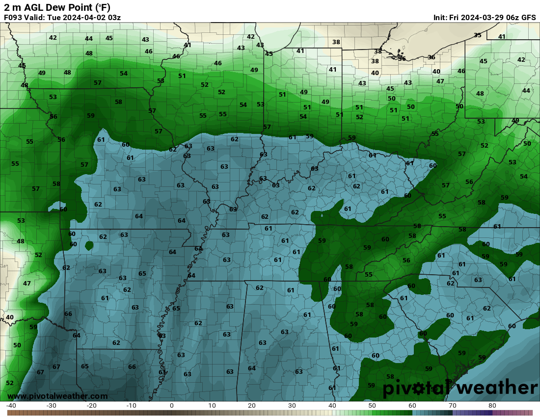
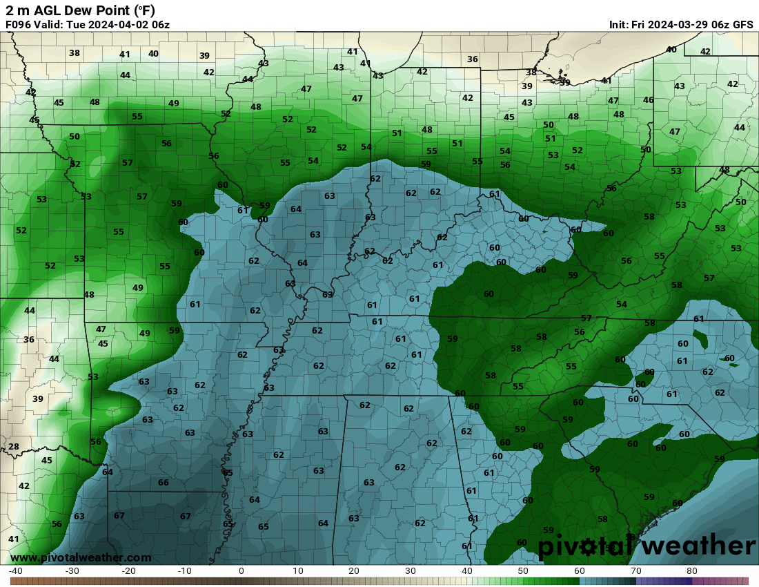
Dew points are another parameter that I monitor for severe thunderstorms. Dews above 58 degrees are sufficient for severe storms.
As you can see, Monday night’s dew points will be well into the sixties.
Monday night 10 pm
Monday night 1 AM.
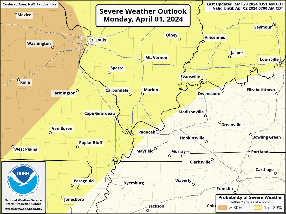
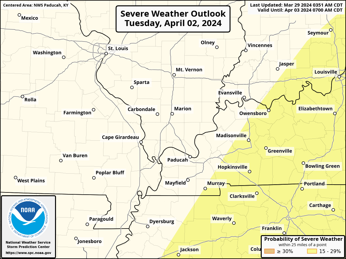
Then, finally on Tuesday the SPC has painted another area for severe thunderstorms. This time over our eastern counties.
The Speed of the frontal passage will be the determining factor in the risk zone placement.
Since these maps are still several days away, don’t walk away with one forecast. These outlooks will need adjusting.
If the front speeds up, then we could avoid the risk. If the front slows down, then the risk would shift westward. Monitor updates.
Locally heavy rain will occur with thunderstorms, as well. If thunderstorms train over the same areas, then some areas will pick up an inch or two of rain in less than an hour. Slow moving storms could cause ponding of water issues. This will also need to be monitored.
Here is the seven day rainfall outlook. I will update this again tomorrow. Over the past six to twelve months it seems these are a tad too high.
Rainfall totals will vary greatly, depending on where thunderstorms track. If a couple of storms impact the same county, then you could easily double these rain totals.
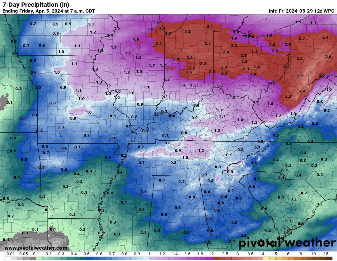
Overall, a fairly common active spring weather pattern as we push deeper into the holiday weekend and early next week.
We will dry out behind the front passage. Cooler.
Too soon for an eclipse forecast. Way too far out. A lot of models show clouds, but you are throwing dice if you believe any given weather forecast that far in advance. 🙂 Stay tuned. We will be monitoring it.
![]()
.
Click here if you would like to return to the top of the page.
This outlook covers southeast Missouri, southern Illinois, western Kentucky, and far northwest Tennessee.

.
Today’s Storm Prediction Center’s (SPC) Severe Weather Outlook
Light green is where thunderstorms may occur but should be below severe levels.
Dark green is a level one risk. Yellow is a level two risk. Orange is a level three (enhanced) risk. Red is a level four (moderate) risk. Pink is a level five (high) risk.
One is the lowest risk. Five is the highest risk.
A severe storm is one that produces 58 mph wind or higher, quarter or larger size hail, and/or a tornado.
Explanation of tables. Click here.
Day One Severe Weather Outlook

Day One Severe Weather Outlook. Zoomed in on our region.

.
Day One Tornado Probability Outlook

Day One Regional Tornado Outlook. Zoomed in on our region.

.
Day One Large Hail Probability Outlook

Day One Regional Hail Outlook. Zoomed in on our region.

.
Day One High wind Probability Outlook

Day One Regional Wind Outlook. Zoomed in on our region.

.
Tomorrow’s severe weather outlook. Day two outlook.

Day Two Outlook. Zoomed in on our region.

.
Day Three Severe Weather Outlook

.

.
The images below are from NOAA’s Weather Prediction Center.
24-hour precipitation outlook..
 .
.
.
48-hour precipitation outlook.
. .
.
![]()
_______________________________________
.

Click here if you would like to return to the top of the page.
Again, as a reminder, these are models. They are never 100% accurate. Take the general idea from them.
What should I take from these?
- The general idea and not specifics. Models usually do well with the generalities.
- The time-stamp is located in the upper left corner.
.
What am I looking at?
You are looking at computer model data. Meteorologists use many different models to forecast the weather.
Occasionally, these maps are in Zulu time. 12z=7 AM. 18z=1 PM. 00z=7 PM. 06z=1 AM
Green represents light rain. Dark green represents moderate rain. Yellow and orange represent heavier rain.
.
This animation is the FVS Model.
Occasionally, these maps are in Zulu time. 12z=7 AM. 18z=1 PM. 00z=7 PM. 06z=1 AM
Double click images to enlarge them. Blue is snow. Pink is a wintry mix. Green is rain.
.
This animation is the NAM Model.
Occasionally, these maps are in Zulu time. 12z=7 AM. 18z=1 PM. 00z=7 PM. 06z=1 AM
Double click images to enlarge them.
.
This animation is the HRRR Model.
Green is rain. Yellow and orange are heavier rain. Pink is a wintry mix. Blue is snow. Dark blue is heavier snow.
Occasionally, these maps are in Zulu time. 12z=7 AM. 18z=1 PM. 00z=7 PM. 06z=1 AM
Double click images to enlarge them.
.
This animation is the GFS Model.
Green is rain. Yellow and orange are heavier rain. Pink is a wintry mix. Blue is snow. Dark blue is heavier snow.
Occasionally, these maps are in Zulu time. 12z=7 AM. 18z=1 PM. 00z=7 PM. 06z=1 AM
Double click images to enlarge them.
.
This animation is the EC Model.
Green is rain. Yellow and orange are heavier rain. Pink is a wintry mix. Blue is snow. Dark blue is heavier snow.
Occasionally, these maps are in Zulu time. 12z=7 AM. 18z=1 PM. 00z=7 PM. 06z=1 AM
Double click images to enlarge them.
..![]()

.
Click here if you would like to return to the top of the page.
.Average high temperatures for this time of the year are around 62 degrees.
Average low temperatures for this time of the year are around 40 degrees.
Average precipitation during this time period ranges from 0.60″ to 1.20″
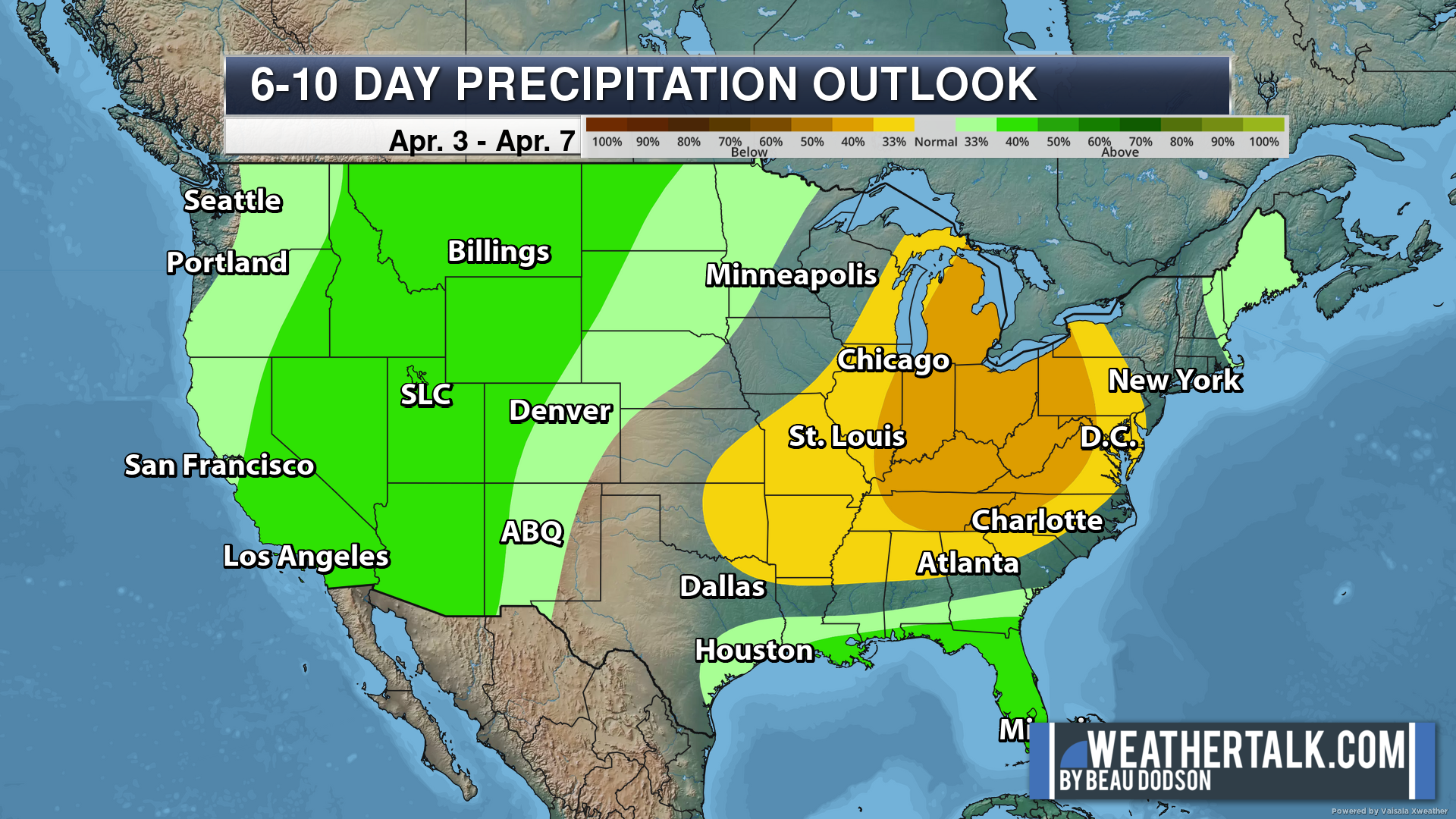
Six to Ten Day Outlook.
Blue is below average. Red is above average. The no color zone represents equal chances.
Average highs for this time of the year are in the lower 60s. Average lows for this time of the year are in the lower 40s.
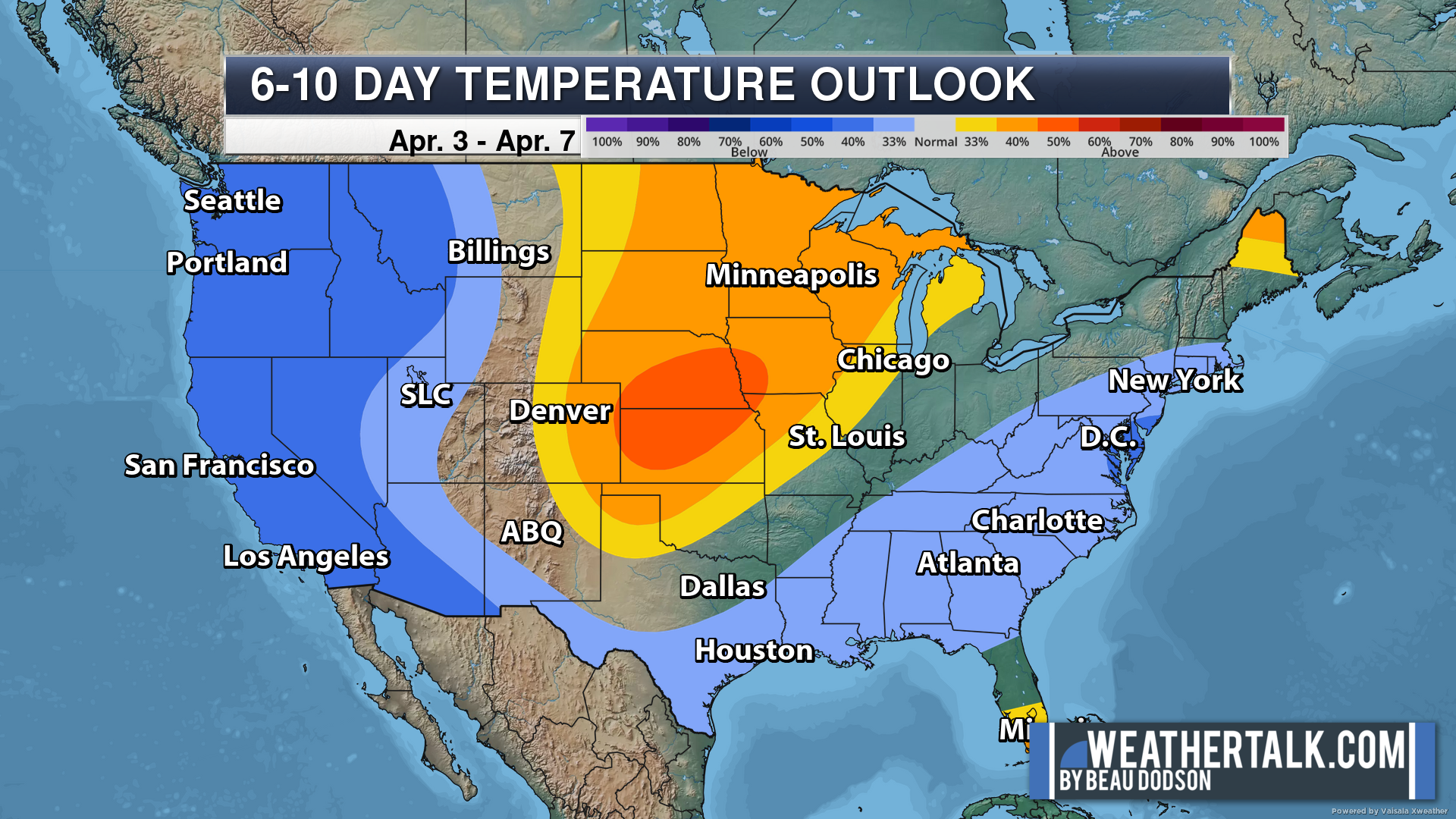
Green is above average precipitation. Yellow and brown favors below average precipitation. Average precipitation for this time of the year is around one inch per week.
.

Average low temperatures for this time of the year are around 41 degrees.
Average precipitation during this time period ranges from 0.60″ to 1.20″
.
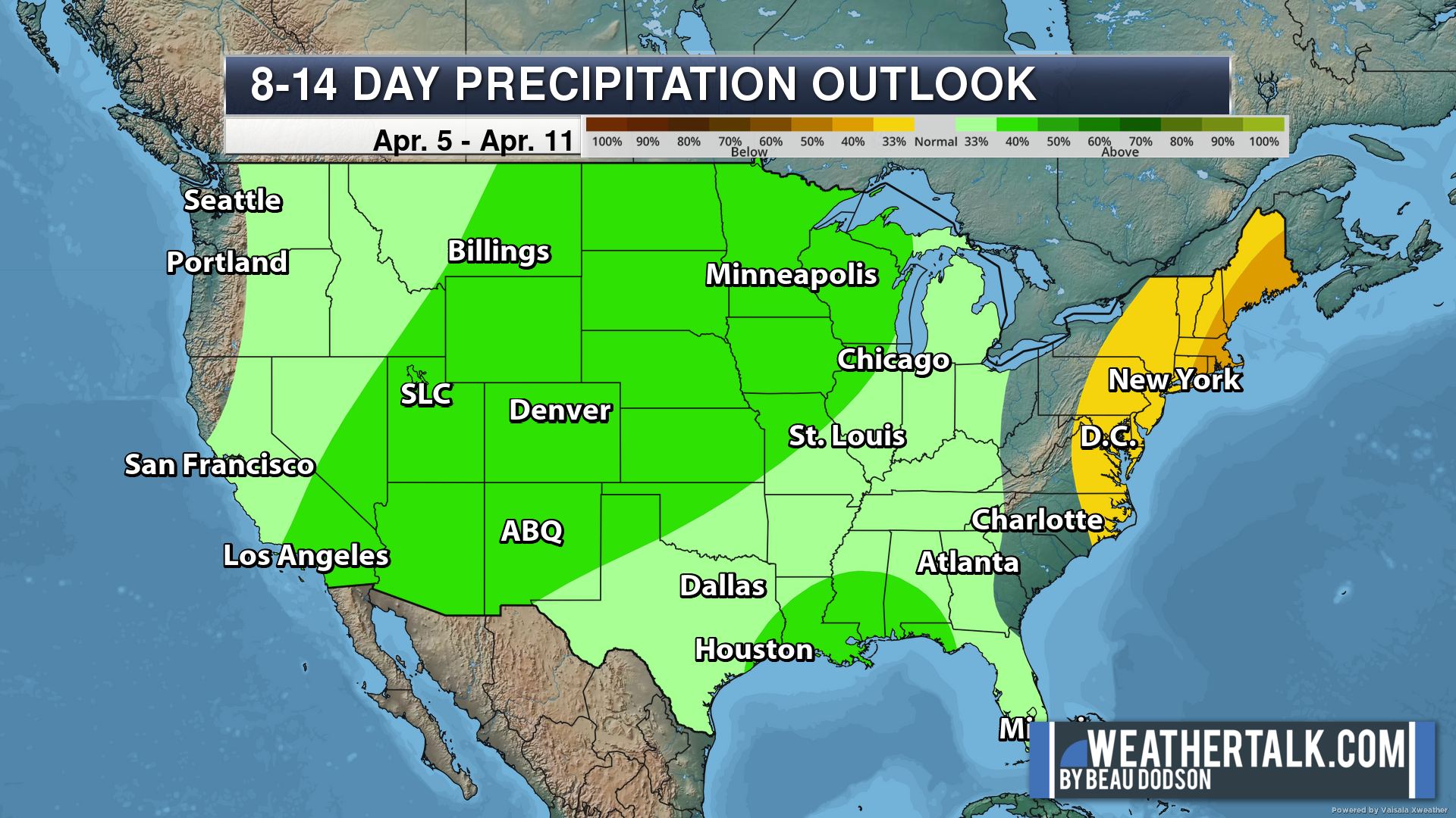
Eight to Fourteen Day Outlook.
Blue is below average. Red is above average. The no color zone represents equal chances.
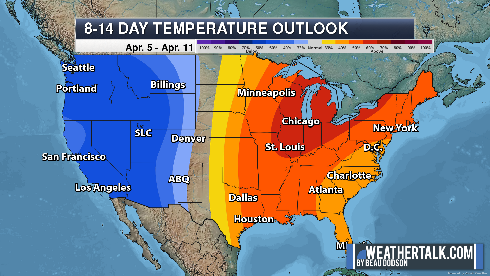
Green is above average precipitation. Yellow and brown favors below average precipitation. Average precipitation for this time of the year is around one inch per week.
.
![]()
The app is for subscribers. Subscribe at www.weathertalk.com/welcome then go to your app store and search for WeatherTalk
Subscribers, PLEASE USE THE APP. ATT and Verizon are not reliable during severe weather. They are delaying text messages.
The app is under WeatherTalk in the app store.

Apple users click here

Android users click here
.

Radars and Lightning Data
Interactive-city-view radars. Clickable watches and warnings.
https://wtalk.co/B3XHASFZ
If the radar is not updating then try another one. If a radar does not appear to be refreshing then hit Ctrl F5. You may also try restarting your browser.
Backup radar site in case the above one is not working.
https://weathertalk.com/morani
Regional Radar
https://imagery.weathertalk.com/prx/RadarLoop.mp4
** NEW ** Zoom radar with chaser tracking abilities!
ZoomRadar
Lightning Data (zoom in and out of your local area)
https://wtalk.co/WJ3SN5UZ
Not working? Email me at beaudodson@usawx.com
National map of weather watches and warnings. Click here.
Storm Prediction Center. Click here.
Weather Prediction Center. Click here.
.

Live lightning data: Click here.
Real time lightning data (another one) https://map.blitzortung.org/#5.02/37.95/-86.99
Our new Zoom radar with storm chases
.
.

Interactive GOES R satellite. Track clouds. Click here.
GOES 16 slider tool. Click here.
College of DuPage satellites. Click here
.

Here are the latest local river stage forecast numbers Click Here.
Here are the latest lake stage forecast numbers for Kentucky Lake and Lake Barkley Click Here.
.
.
Find Beau on Facebook! Click the banner.


 .
.