
Click one of the links below to take you directly to that section
![]()
![]()
![]()
![]()
![]()
![]()
![]()
.

.
Seven Day Hazardous Weather Outlook
1. Is lightning in the forecast? YES. I am watching Friday into the middle of next week.
2. Are severe thunderstorms in the forecast? MONITOR. I am watching Sunday into the middle of next week. Several disturbances will bring shower and thunderstorm chances. Placement of the storms and timing will need to be worked out.
3. Is flash flooding in the forecast? NOT AT THIS TIME.
4. Will non-thunderstorm winds top 40 mph? NOT AT THIS TIME.
5. Will the heat index exceed 100 degrees? NO.
6. Will the wind chill dip below 10 degrees? NO.
7. Is measurable snow and/or sleet in the forecast? NO.
8. Is freezing rain/ice in the forecast? NO.
Freezing rain is rain that falls and instantly freezes on objects such as trees and power lines Freezing fog possible, as well.
.

Fire weather risk level.
Tuesday through Tuesday night: 3. Very low risk.
Wednesday: 3. Very low risk.
Wednesday night: 5. Medium risk.
Fire Weather Discussion
It will be breezy today with southwest winds at 10 to 20 mph with some gusts to around 30 mph, becoming west during the afternoon and decreasing this evening. Afternoon humidity will drop into the 35 to 45 percent range. Drier conditions and lighter winds can be expected Wednesday with afternoon humidity dropping into the 25 to 35 percent range. Afternoon humidity readings Thursday will be in the middle 20s to around 30 percent.
A Haines Index of 6 means a high potential for an existing fire to become large or exhibit erratic fire behavior, 5 means medium potential, 4 means low potential, and anything less than 4 means very low potential.
.

THE FORECAST IS GOING TO VARY FROM LOCATION TO LOCATION.
Scroll down to see your local forecast details.
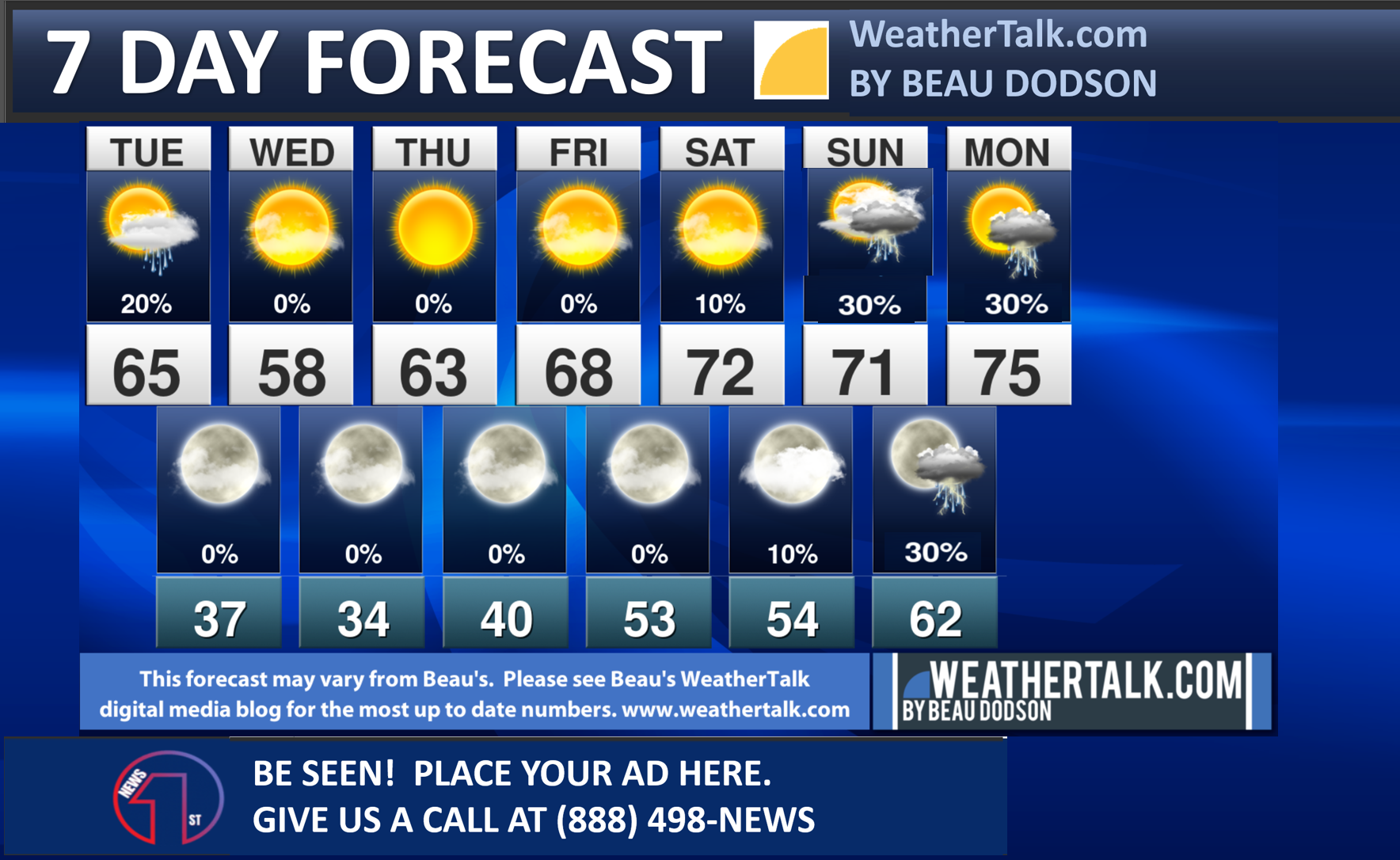
Seven-day forecast for southeast Missouri, southern Illinois, western Kentucky, and western Tennessee.
This is a BLEND for the region. Scroll down to see the region by region forecast.
48-hour forecast Graphics


.
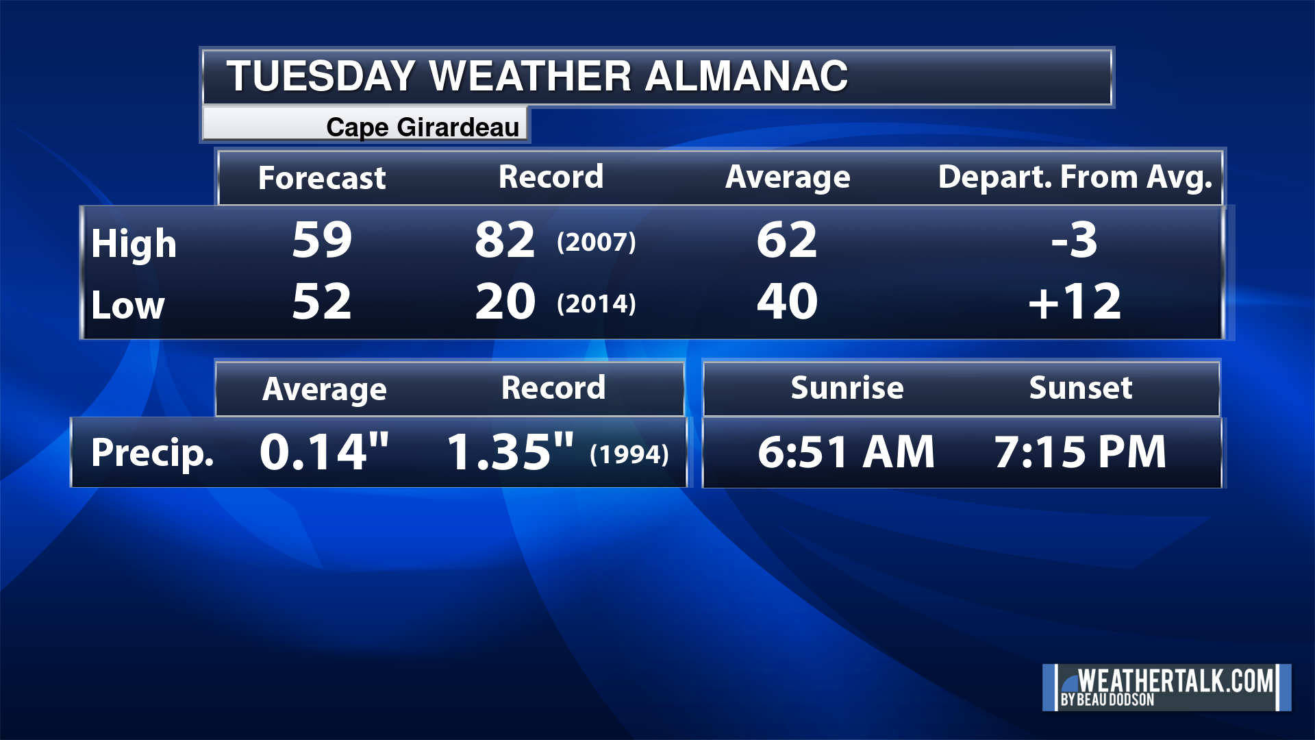
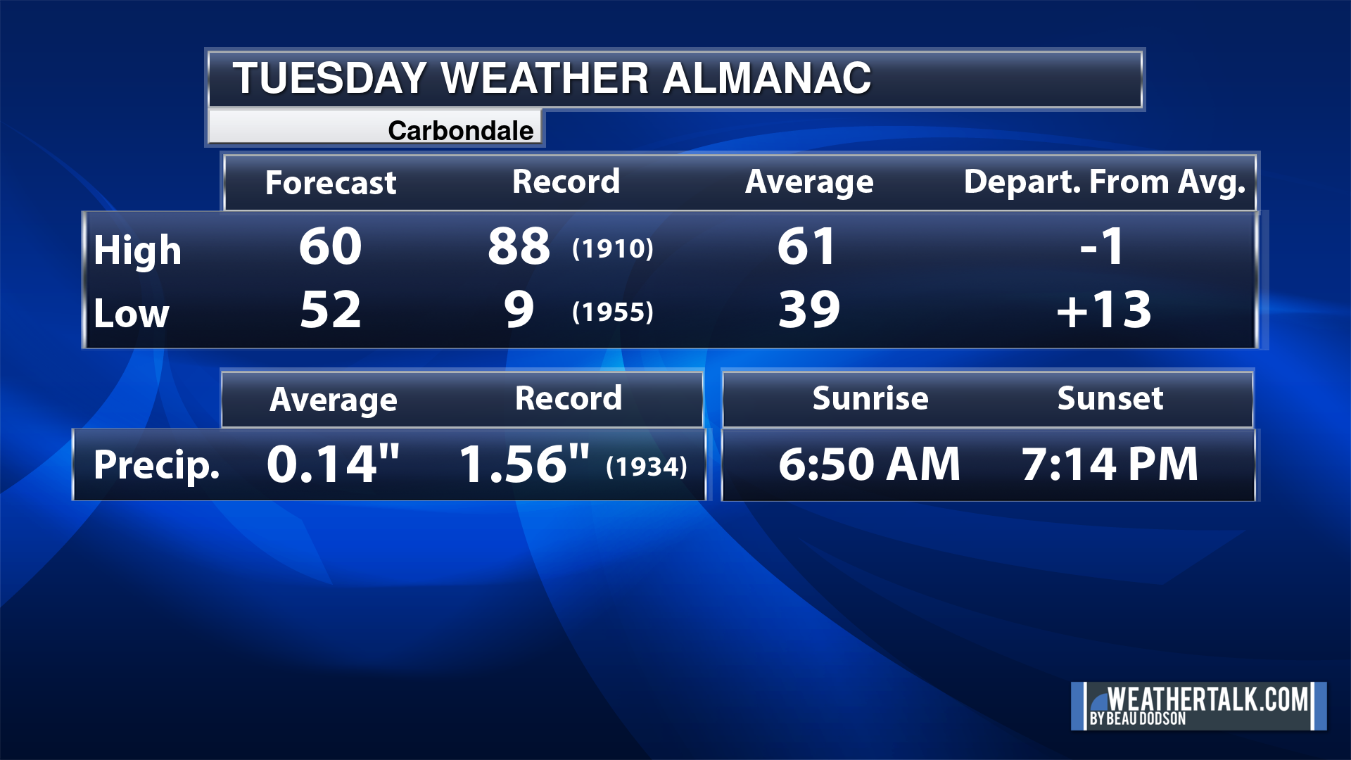
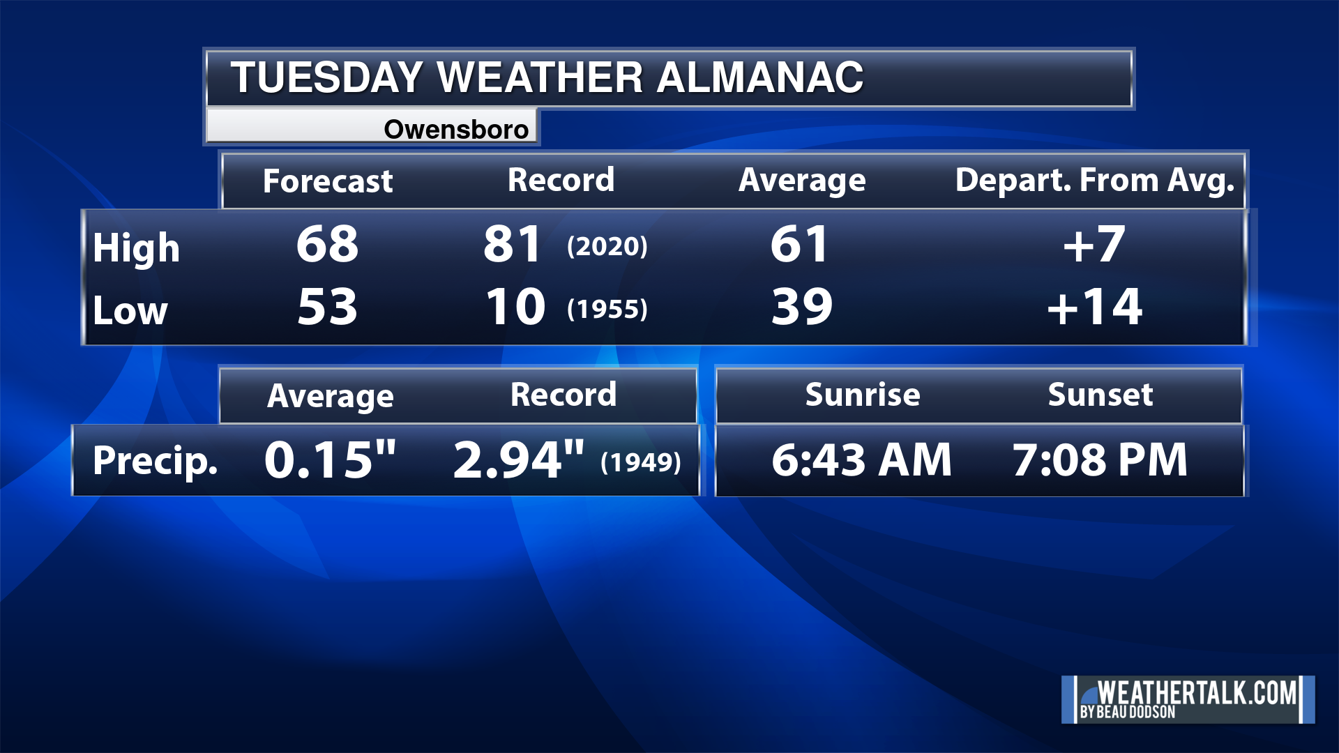
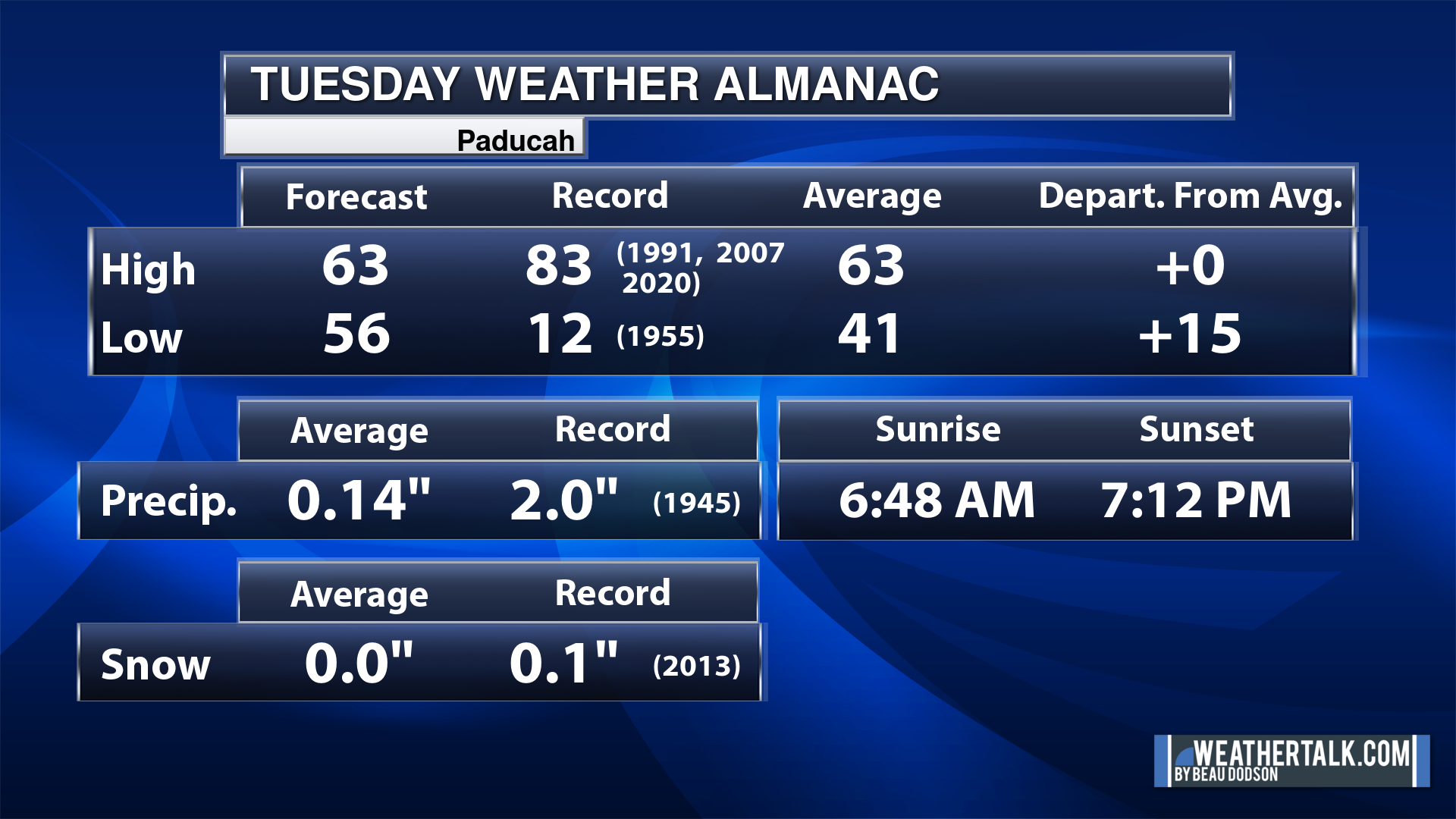
Today’s Local Almanacs (for a few select cities). Your location will be comparable.
Note, the low is this morning’s low and not tomorrows.
The forecast temperature shows you today’s expected high and this morning’s low.
The graphic shows you the record high and record low for today. It shows you what year that occurred, as well.
It then shows you what today’s average temperature is.
It shows you the departures (how may degrees above or below average temperatures will be ).
It shows you the average precipitation for today. Average comes from thirty years of rain totals.
It also shows you the record rainfall for the date and what year that occurred.
The sunrise and sunset are also shown.

![]()
.
.
Tuesday Forecast: Morning clouds. Becoming partly sunny. A few light showers remaining over mainly Kentucky.
What is the chance of precipitation?
Far northern southeast Missouri ~ 10%
Southeast Missouri ~ 10%
The Missouri Bootheel ~ 10%
I-64 Corridor of southern Illinois ~ 20%
Southern Illinois ~ 20%
Extreme southern Illinois (southern seven counties) ~ 20%
Far western Kentucky (Purchase area) ~ 20%
The Pennyrile area of western KY ~ 30%
Northwest Kentucky (near Indiana border) ~ 30%
Northwest Tennessee ~ 20%
Coverage of precipitation: Widely scattered
Timing of the precipitation: Before 4 PM.
Far northern southeast Missouri ~ 48° to 52°
Southeast Missouri ~ 54° to 56°
The Missouri Bootheel ~ 54° to 56°
I-64 Corridor of southern Illinois ~ 58° to 62°
Southern Illinois ~ 56° to 60°
Extreme southern Illinois (southern seven counties) ~ 58° to 62°
Far western Kentucky ~ 62° to 65°
The Pennyrile area of western KY ~ 64° to 68°
Northwest Kentucky (near Indiana border) ~ 62° to 65°
Northwest Tennessee ~ 62° to 65°
Winds will be from this direction: West southwest 15 to 30 mph.
Wind chill or heat index (feels like) temperature forecast: 48° to 60°
What impacts are anticipated from the weather? Wet roadways
Should I cancel my outdoor plans? No, but monitor the Beau Dodson Weather Radars.
UV Index: 6. High.
Sunrise: 6:49 AM
Sunset: 7:13 PM
.
Tuesday Night Forecast: Clearing and colder.
What is the chance of precipitation?
Far northern southeast Missouri ~ 0%
Southeast Missouri ~ 0%
The Missouri Bootheel ~ 0%
I-64 Corridor of southern Illinois ~ 0%
Southern Illinois ~ 0%
Extreme southern Illinois (southern seven counties) ~ 0%
Far western Kentucky (Purchase area) ~ 0%
The Pennyrile area of western KY ~ 0%
Northwest Kentucky (near Indiana border) ~ 0%
Northwest Tennessee ~ 0%
Coverage of precipitation:
Timing of the precipitation:
Temperature range:
Far northern southeast Missouri ~ 30° to 32°
Southeast Missouri ~ 33° to 36°
The Missouri Bootheel ~ 36° to 38°
I-64 Corridor of southern Illinois ~ 30° to 32°
Southern Illinois ~ 32° to 34°
Extreme southern Illinois (southern seven counties) ~ 33° to 36°
Far western Kentucky ~ 34° to 38°
The Pennyrile area of western KY ~ 34° to 38°
Northwest Kentucky (near Indiana border) ~ 34° to 38°
Northwest Tennessee ~ 34° to 38°
Winds will be from this direction: West northwest 7 to 14 mph
Wind chill or heat index (feels like) temperature forecast: 28° to 38°
What impacts are anticipated from the weather?
Should I cancel my outdoor plans? No
Moonrise: 8:48 PM
Moonset: 7:24 AM
The phase of the moon: Waning Gibbous
.
Wednesday Forecast: Mostly sunny.
What is the chance of precipitation?
Far northern southeast Missouri ~ 0%
Southeast Missouri ~ 0%
The Missouri Bootheel ~ 0%
I-64 Corridor of southern Illinois ~ 0%
Southern Illinois ~ 0%
Extreme southern Illinois (southern seven counties) ~ 0%
Far western Kentucky (Purchase area) ~ 0%
The Pennyrile area of western KY ~ 0%
Northwest Kentucky (near Indiana border) ~ 0%
Northwest Tennessee ~ 0%
Coverage of precipitation:
Timing of the precipitation:
Far northern southeast Missouri ~ 55° to 58°
Southeast Missouri ~ 55° to 58°
The Missouri Bootheel ~ 56° to 58°
I-64 Corridor of southern Illinois ~ 55° to 58°
Southern Illinois ~ 55° to 58°
Extreme southern Illinois (southern seven counties) ~ 56° to 58°
Far western Kentucky ~ 56° to 60°
The Pennyrile area of western KY ~ 56° to 60°
Northwest Kentucky (near Indiana border) ~ 56° to 60°
Northwest Tennessee ~ 60° to 62°
Winds will be from this direction: Northwest 7 to 14 mph
Wind chill or heat index (feels like) temperature forecast: 52° to 58°
What impacts are anticipated from the weather?
Should I cancel my outdoor plans? No
UV Index: 7. High.
Sunrise: 6:48 AM
Sunset: 7:14 PM
.
Wednesday Night Forecast: Mostly clear.
What is the chance of precipitation?
Far northern southeast Missouri ~ 0%
Southeast Missouri ~ 0%
The Missouri Bootheel ~ 0%
I-64 Corridor of southern Illinois ~ 0%
Southern Illinois ~ 0%
Extreme southern Illinois (southern seven counties) ~ 0%
Far western Kentucky (Purchase area) ~ 0%
The Pennyrile area of western KY ~ 0%
Northwest Kentucky (near Indiana border) ~ 0%
Northwest Tennessee ~ 0%
Coverage of precipitation:
Timing of the precipitation:
Temperature range:
Far northern southeast Missouri ~ 28° to 32°
Southeast Missouri ~ 32° to 34°
The Missouri Bootheel ~ 32° to 35°
I-64 Corridor of southern Illinois ~ 28° to 32°
Southern Illinois ~ 30° to 34°
Extreme southern Illinois (southern seven counties) ~ 32° to 34°
Far western Kentucky ~ 32° to 34°
The Pennyrile area of western KY ~ 32° to 34°
Northwest Kentucky (near Indiana border) ~ 32° to 34°
Northwest Tennessee ~ 33° to 36°
Winds will be from this direction: North 6 to 12 mph
Wind chill or heat index (feels like) temperature forecast: 26° to 34°
What impacts are anticipated from the weather?
Should I cancel my outdoor plans? No
Moonrise: 9:47 PM
Moonset: 7:47 AM
The phase of the moon: Waning Gibbous
.
Thursday Forecast: Mostly sunny.
What is the chance of precipitation?
Far northern southeast Missouri ~ 0%
Southeast Missouri ~ 0%
The Missouri Bootheel ~ 0%
I-64 Corridor of southern Illinois ~ 0%
Southern Illinois ~ 0%
Extreme southern Illinois (southern seven counties) ~ 0%
Far western Kentucky (Purchase area) ~ 0%
The Pennyrile area of western KY ~ 0%
Northwest Kentucky (near Indiana border) ~ 0%
Northwest Tennessee ~ 0%
Coverage of precipitation:
Timing of the precipitation:
Far northern southeast Missouri ~ 62° to 64°
Southeast Missouri ~ 62° to 64°
The Missouri Bootheel ~ 62° to 64°
I-64 Corridor of southern Illinois ~ 62° to 64°
Southern Illinois ~ 62° to 64°
Extreme southern Illinois (southern seven counties) ~ 62° to 64°
Far western Kentucky ~ 62° to 64°
The Pennyrile area of western KY ~ 62° to 64°
Northwest Kentucky (near Indiana border) ~ 62° to 64°
Northwest Tennessee ~ 62° to 64°
Winds will be from this direction: Variable wind direction 7 to 14 mph
Wind chill or heat index (feels like) temperature forecast: 58° to 64°
What impacts are anticipated from the weather?
Should I cancel my outdoor plans? No
UV Index: 7. High.
Sunrise: 6:46 AM
Sunset: 7:15 PM
.
Thursday Night Forecast: Mostly clear.
What is the chance of precipitation?
Far northern southeast Missouri ~ 0%
Southeast Missouri ~ 0%
The Missouri Bootheel ~ 0%
I-64 Corridor of southern Illinois ~ 0%
Southern Illinois ~ 0%
Extreme southern Illinois (southern seven counties) ~ 0%
Far western Kentucky (Purchase area) ~ 0%
The Pennyrile area of western KY ~ 0%
Northwest Kentucky (near Indiana border) ~ 0%
Northwest Tennessee ~ 0%
Coverage of precipitation:
Timing of the precipitation:
Temperature range:
Far northern southeast Missouri ~ 38° to 42°
Southeast Missouri ~ 38° to 42°
The Missouri Bootheel ~ 38° to 42°
I-64 Corridor of southern Illinois ~ 38° to 42°
Southern Illinois ~ 38° to 42°
Extreme southern Illinois (southern seven counties) ~ 38° to 42°
Far western Kentucky ~ 38° to 42°
The Pennyrile area of western KY ~ 38° to 42°
Northwest Kentucky (near Indiana border) ~ 38° to 42°
Northwest Tennessee ~ 38° to 42°
Winds will be from this direction: South southwest 7 to 14 mph.
Wind chill or heat index (feels like) temperature forecast: 34° to 40°
What impacts are anticipated from the weather?
Should I cancel my outdoor plans? No
Moonrise: 10:51 PM
Moonset: 8:14 AM
The phase of the moon: Waning Gibbous
.
Friday Forecast: Mostly sunny.
What is the chance of precipitation?
Far northern southeast Missouri ~ 0%
Southeast Missouri ~ 0%
The Missouri Bootheel ~ 0%
I-64 Corridor of southern Illinois ~ 0%
Southern Illinois ~ 0%
Extreme southern Illinois (southern seven counties) ~ 0%
Far western Kentucky (Purchase area) ~ 0%
The Pennyrile area of western KY ~ 0%
Northwest Kentucky (near Indiana border) ~ 0%
Northwest Tennessee ~ 0%
Coverage of precipitation:
Timing of the precipitation:
Far northern southeast Missouri ~ 68° to 72°
Southeast Missouri ~ 68° to 72°
The Missouri Bootheel ~ 68° to 72°
I-64 Corridor of southern Illinois ~ 68° to 72°
Southern Illinois ~ 68° to 72°
Extreme southern Illinois (southern seven counties) ~ 68° to 72°
Far western Kentucky ~ 68° to 72°
The Pennyrile area of western KY ~ 68° to 72°
Northwest Kentucky (near Indiana border) ~ 68° to 72°
Northwest Tennessee ~ 68° to 72°
Winds will be from this direction: South southwest 10 to 20 mph. Gusty.
Wind chill or heat index (feels like) temperature forecast: 68° to 72°
What impacts are anticipated from the weather?
Should I cancel my outdoor plans? No
UV Index: 7. High.
Sunrise: 6:45 AM
Sunset: 7:16 PM
.
Friday Night Forecast: Partly cloudy. A chance of thunderstorms over our northern counties.
What is the chance of precipitation?
Far northern southeast Missouri ~ 20%
Southeast Missouri ~ 20%
The Missouri Bootheel ~ 0%
I-64 Corridor of southern Illinois ~ 20%
Southern Illinois ~ 20%
Extreme southern Illinois (southern seven counties) ~ 10%
Far western Kentucky (Purchase area) ~ 0%
The Pennyrile area of western KY ~ 0%
Northwest Kentucky (near Indiana border) ~ 20%
Northwest Tennessee ~ 0%
Coverage of precipitation: Widely scattered
Timing of the precipitation: After 10 PM
Temperature range:
Far northern southeast Missouri ~ 50° to 52°
Southeast Missouri ~ 50° to 52°
The Missouri Bootheel ~ 50° to 52°
I-64 Corridor of southern Illinois ~ 50° to 52°
Southern Illinois ~ 50° to 52°
Extreme southern Illinois (southern seven counties) ~ 50° to 52°
Far western Kentucky ~ 50° to 52°
The Pennyrile area of western KY ~ 50° to 52°
Northwest Kentucky (near Indiana border) ~ 50° to 52°
Northwest Tennessee ~ 50° to 52°
Winds will be from this direction: South southwest 15 to 30 mph.
Wind chill or heat index (feels like) temperature forecast: 50° to 52°
What impacts are anticipated from the weather?
Should I cancel my outdoor plans? No
Moonrise: 11:55 PM
Moonset: 8:45 AM
The phase of the moon: Waning Gibbous
.
Click here if you would like to return to the top of the page.

-
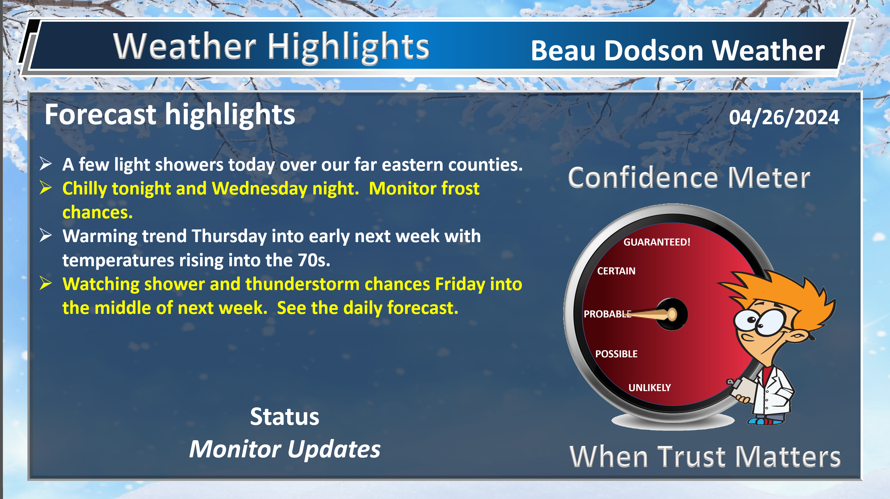
- A few remaining showers and thunderstorms.
- Chilly tonight and tomorrow night.
- Warming trends late week.
- Watching shower and thunderstorm chances Easter and Monday
Weather advice:
Do you have any suggestions or comments? Email me at beaudodson@usawx.com
Make sure you have three to five ways of receiving your severe weather information.
.
Beau’s Forecast Discussion
Good day, everyone.
Our widespread rain event has pushed off to the east. The region received beneficial rain yesterday afternoon and evening.
Strong and gusty winds of 30 to 50 mph were reported across the region, as well. Several structures were damaged in southeast Missouri. Several trees and large branches fell in the region with thousands without power.
Scattered power outages were an issue.
The winds were not from thunderstorms, but rather because of rapidly falling and rising barometric pressure. A tight pressure gradient.
Typical spring winds.
A few showers may linger today, but the bulk of the rain is over. Rain showers will be more likely over the Pennyrile area of western Kentucky vs areas farther to the west.
No big deal with little additional in the way of rain totals.
We need rain, because we have been in drought.
It will be chilly tonight with lows in the 30s. Lows will dip into the 30s Wednesday night, as well. I can’t rule out frost.
A complicated weather forecast will develop Friday into the middle of next week. We have several potential severe weather days. But, confidence in forecasting severe weather is low.
A frontal boundary will drape itself to our north Friday into Sunday. The exact placement of that front will be the deciding factor as to where the severe weather threat will be.
We may end up with a threat over our northern counties and then the threat shifts southward with time.
If the front pushes too far north, then we won’t have severe weather concerns.
So, as you can see, there are questions about the forecast.
I will need to fine tune the timing of thunderstorms chances, the placement of thunderstorms chances, and watch where the front drapes itself.
Stay tuned and monitor updates concerning this potential series of weather events.
It does appear a strong cold front may move through the region next Tuesday or Wednesday. Again, there are questions this far out.
I suspect the Storm Prediction Center will have to add some risk zones in future updates.
From the Storm Prediction Center
If a northern-stream upper trough over central Canada can phase with the ejecting lower-latitude trough over the western CONUS, as some guidance suggests, then a more organized severe threat may exist, focused on Day 7/Monday and Day 8/Tuesday. At this point, the regions of interest include locations along/east of a surface dryline over the southern/central Plains, and along/south of a warm front draped across the OH Valley. Both instability and deep-layer shear appear strong enough for severe convection. But, there are still some substantial differences in the location of greatest severe risk next Monday and Tuesday. Trends in guidance will be closely monitored. If deterministic and ensemble guidance can come into better agreement regarding the evolution of the upper trough, along with related surface features, then a broad 15% severe area may be needed for next Monday and/or Tuesday in later outlooks.
It will be warm Friday into early next week with widespread 70s returning.
![]()
.
Click here if you would like to return to the top of the page.
This outlook covers southeast Missouri, southern Illinois, western Kentucky, and far northwest Tennessee.

.
Today’s Storm Prediction Center’s (SPC) Severe Weather Outlook
Light green is where thunderstorms may occur but should be below severe levels.
Dark green is a level one risk. Yellow is a level two risk. Orange is a level three (enhanced) risk. Red is a level four (moderate) risk. Pink is a level five (high) risk.
One is the lowest risk. Five is the highest risk.
A severe storm is one that produces 58 mph wind or higher, quarter or larger size hail, and/or a tornado.
Explanation of tables. Click here.
Day One Severe Weather Outlook

Day One Severe Weather Outlook. Zoomed in on our region.

.
Day One Tornado Probability Outlook

Day One Regional Tornado Outlook. Zoomed in on our region.

.
Day One Large Hail Probability Outlook

Day One Regional Hail Outlook. Zoomed in on our region.

.
Day One High wind Probability Outlook

Day One Regional Wind Outlook. Zoomed in on our region.

.
Tomorrow’s severe weather outlook. Day two outlook.

Day Two Outlook. Zoomed in on our region.

.
Day Three Severe Weather Outlook

.

.
The images below are from NOAA’s Weather Prediction Center.
24-hour precipitation outlook..
 .
.
.
48-hour precipitation outlook.
. .
.
![]()
_______________________________________
.

Click here if you would like to return to the top of the page.
Again, as a reminder, these are models. They are never 100% accurate. Take the general idea from them.
What should I take from these?
- The general idea and not specifics. Models usually do well with the generalities.
- The time-stamp is located in the upper left corner.
.
What am I looking at?
You are looking at computer model data. Meteorologists use many different models to forecast the weather.
Occasionally, these maps are in Zulu time. 12z=7 AM. 18z=1 PM. 00z=7 PM. 06z=1 AM
Green represents light rain. Dark green represents moderate rain. Yellow and orange represent heavier rain.
.
This animation is the FVS Model.
Occasionally, these maps are in Zulu time. 12z=7 AM. 18z=1 PM. 00z=7 PM. 06z=1 AM
Double click images to enlarge them. Blue is snow. Pink is a wintry mix. Green is rain.
.
This animation is the NAM Model.
Occasionally, these maps are in Zulu time. 12z=7 AM. 18z=1 PM. 00z=7 PM. 06z=1 AM
Double click images to enlarge them.
.
This animation is the HRRR Model.
Green is rain. Yellow and orange are heavier rain. Pink is a wintry mix. Blue is snow. Dark blue is heavier snow.
Occasionally, these maps are in Zulu time. 12z=7 AM. 18z=1 PM. 00z=7 PM. 06z=1 AM
Double click images to enlarge them.
.
This animation is the GFS Model.
Green is rain. Yellow and orange are heavier rain. Pink is a wintry mix. Blue is snow. Dark blue is heavier snow.
Occasionally, these maps are in Zulu time. 12z=7 AM. 18z=1 PM. 00z=7 PM. 06z=1 AM
Double click images to enlarge them.
.
This animation is the EC Model.
Green is rain. Yellow and orange are heavier rain. Pink is a wintry mix. Blue is snow. Dark blue is heavier snow.
Occasionally, these maps are in Zulu time. 12z=7 AM. 18z=1 PM. 00z=7 PM. 06z=1 AM
Double click images to enlarge them.
..![]()

.
Click here if you would like to return to the top of the page.
.Average high temperatures for this time of the year are around 62 degrees.
Average low temperatures for this time of the year are around 40 degrees.
Average precipitation during this time period ranges from 0.60″ to 1.20″
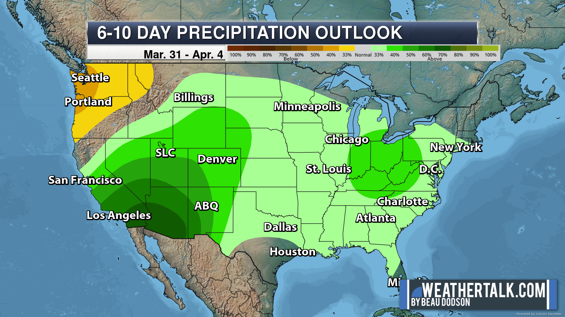
Six to Ten Day Outlook.
Blue is below average. Red is above average. The no color zone represents equal chances.
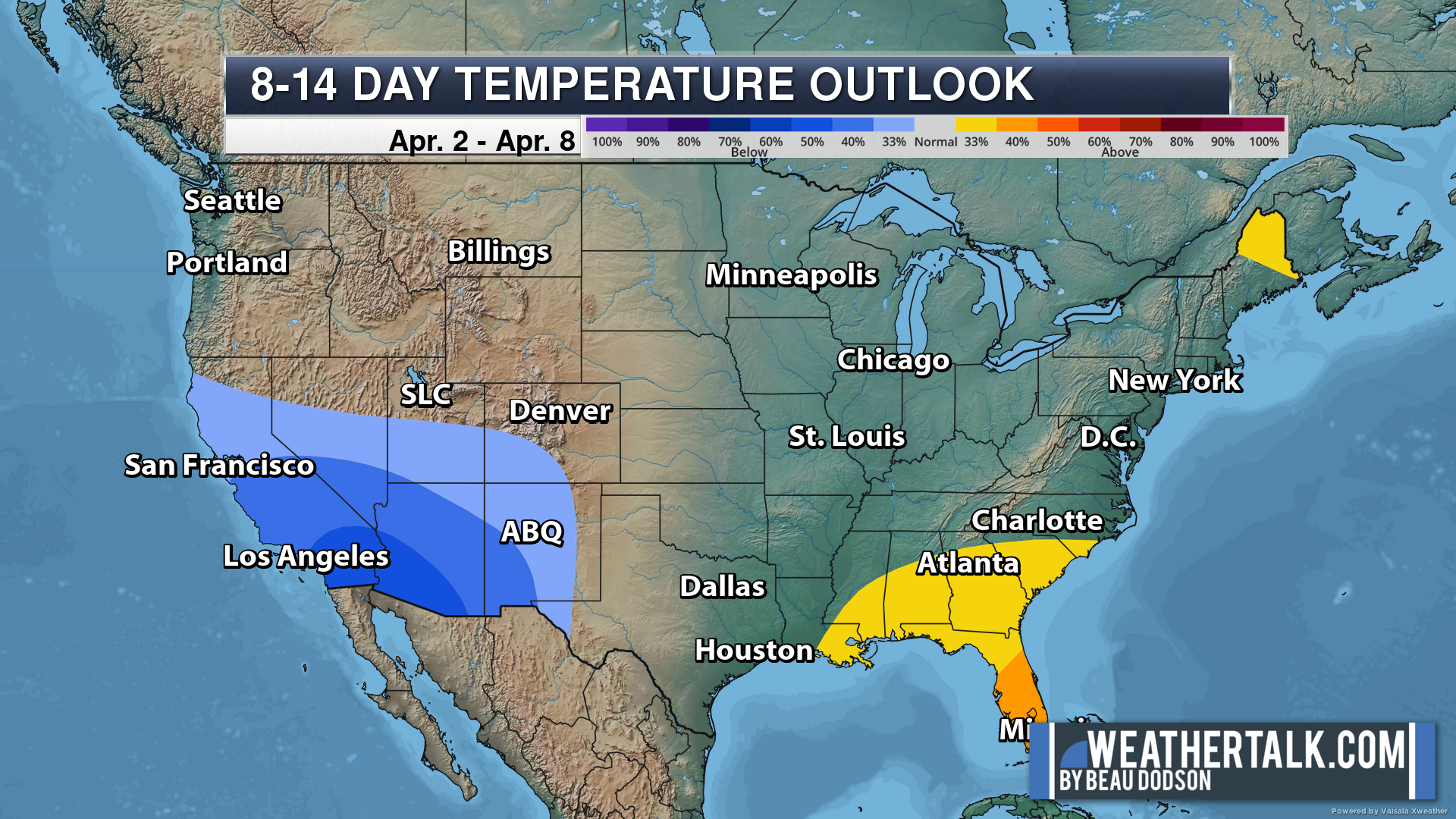
Average highs for this time of the year are in the lower 60s. Average lows for this time of the year are in the lower 40s.
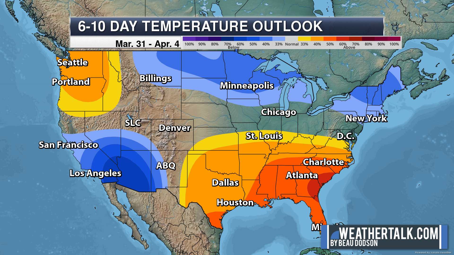
Green is above average precipitation. Yellow and brown favors below average precipitation. Average precipitation for this time of the year is around one inch per week.
.

Average low temperatures for this time of the year are around 41 degrees.
Average precipitation during this time period ranges from 0.60″ to 1.20″
.
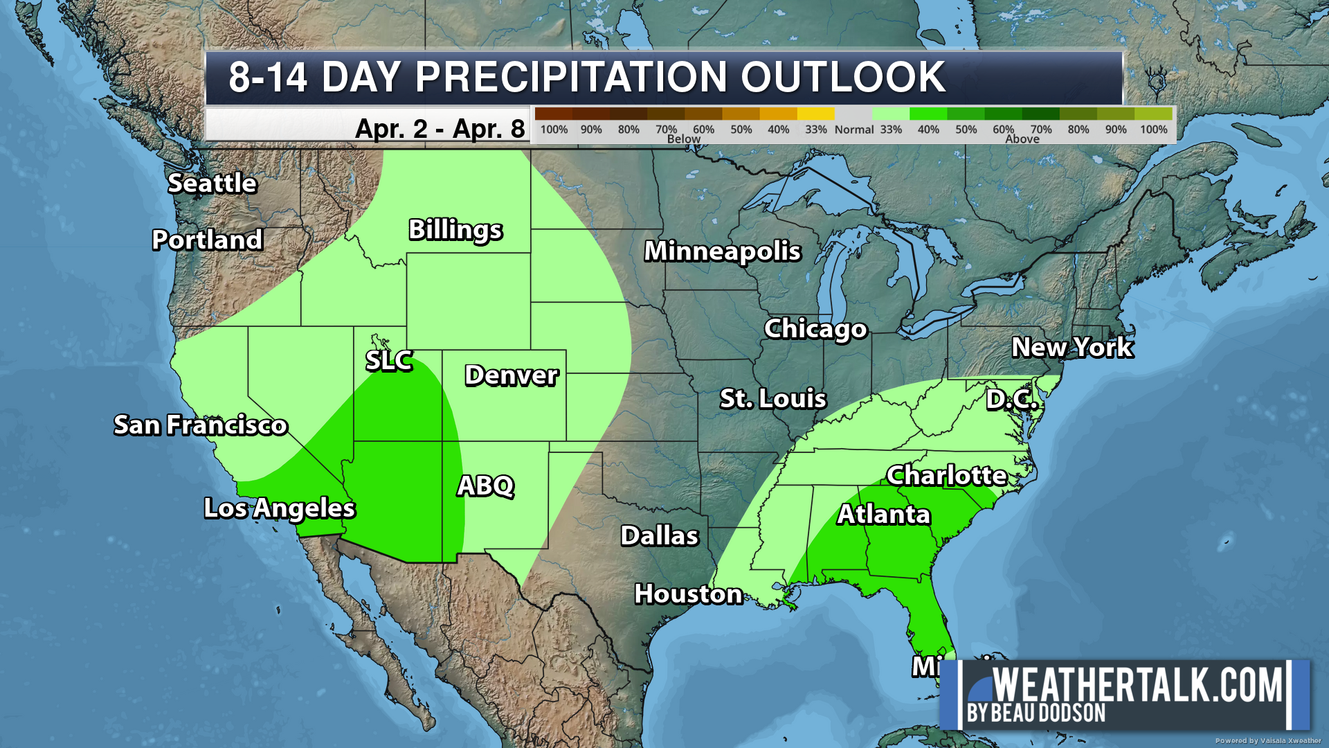
Eight to Fourteen Day Outlook.
Blue is below average. Red is above average. The no color zone represents equal chances.
Green is above average precipitation. Yellow and brown favors below average precipitation. Average precipitation for this time of the year is around one inch per week.
.
![]()
The app is for subscribers. Subscribe at www.weathertalk.com/welcome then go to your app store and search for WeatherTalk
Subscribers, PLEASE USE THE APP. ATT and Verizon are not reliable during severe weather. They are delaying text messages.
The app is under WeatherTalk in the app store.

Apple users click here

Android users click here
.

Radars and Lightning Data
Interactive-city-view radars. Clickable watches and warnings.
https://wtalk.co/B3XHASFZ
If the radar is not updating then try another one. If a radar does not appear to be refreshing then hit Ctrl F5. You may also try restarting your browser.
Backup radar site in case the above one is not working.
https://weathertalk.com/morani
Regional Radar
https://imagery.weathertalk.com/prx/RadarLoop.mp4
** NEW ** Zoom radar with chaser tracking abilities!
ZoomRadar
Lightning Data (zoom in and out of your local area)
https://wtalk.co/WJ3SN5UZ
Not working? Email me at beaudodson@usawx.com
National map of weather watches and warnings. Click here.
Storm Prediction Center. Click here.
Weather Prediction Center. Click here.
.

Live lightning data: Click here.
Real time lightning data (another one) https://map.blitzortung.org/#5.02/37.95/-86.99
Our new Zoom radar with storm chases
.
.

Interactive GOES R satellite. Track clouds. Click here.
GOES 16 slider tool. Click here.
College of DuPage satellites. Click here
.

Here are the latest local river stage forecast numbers Click Here.
Here are the latest lake stage forecast numbers for Kentucky Lake and Lake Barkley Click Here.
.
.
Find Beau on Facebook! Click the banner.


 .
.