
Click one of the links below to take you directly to that section
![]()
![]()
![]()
![]()
![]()
![]()
![]()
.

.
Seven Day Hazardous Weather Outlook
1. Is lightning in the forecast? YES. Lightning is possible today into tomorrow. Lightning is possible this coming weekend. I will keep an eye on Sunday and Monday.
2. Are severe thunderstorms in the forecast? MONITOR. There is a low end risk of severe weather over Missouri this afternoon and tonight. There is a low end risk of severe weather over Kentucky and Indiana Tuesday late morning and afternoon. The main concern will be gusty wind and perhaps a report of hail.
I will keep an eye on early next week.
3. Is flash flooding in the forecast? NOT AT THIS TIME. Locally heavy rain is possible Monday and Monday night, but the risk of flooding appears low.
4. Will non-thunderstorm winds top 40 mph? YES. Winds will gust above 40 mph today and tonight. These will be gradient winds because of the deep area of low pressure.
5. Will the heat index exceed 100 degrees? NO.
6. Will the wind chill dip below 10 degrees? NO.
7. Is measurable snow and/or sleet in the forecast? NO.
8. Is freezing rain/ice in the forecast? NO.
Freezing rain is rain that falls and instantly freezes on objects such as trees and power lines Freezing fog possible, as well.
.

Fire weather risk level.
Monday through Monday night: 3. Very low risk.
Tuesday: 3. Very low risk.
Tuesday night:3. Very low risk.
Fire Weather Discussion
An approaching storm system will spread rain and maybe a few thunderstorms into the region later today into tonight. Expect strong winds today, especially late this afternoon and into this evening, sustained 20 to 30 mph and gusts 40 to 55 mph. Strong transport within a modest mixed layer should yield very good dispersion both today and Tuesday.
Gusty north winds and low RH are forecast Saturday behind a cold front. This should lead to good smoke dispersion despite modest mixing heights.
A Haines Index of 6 means a high potential for an existing fire to become large or exhibit erratic fire behavior, 5 means medium potential, 4 means low potential, and anything less than 4 means very low potential.
.

THE FORECAST IS GOING TO VARY FROM LOCATION TO LOCATION.
Scroll down to see your local forecast details.
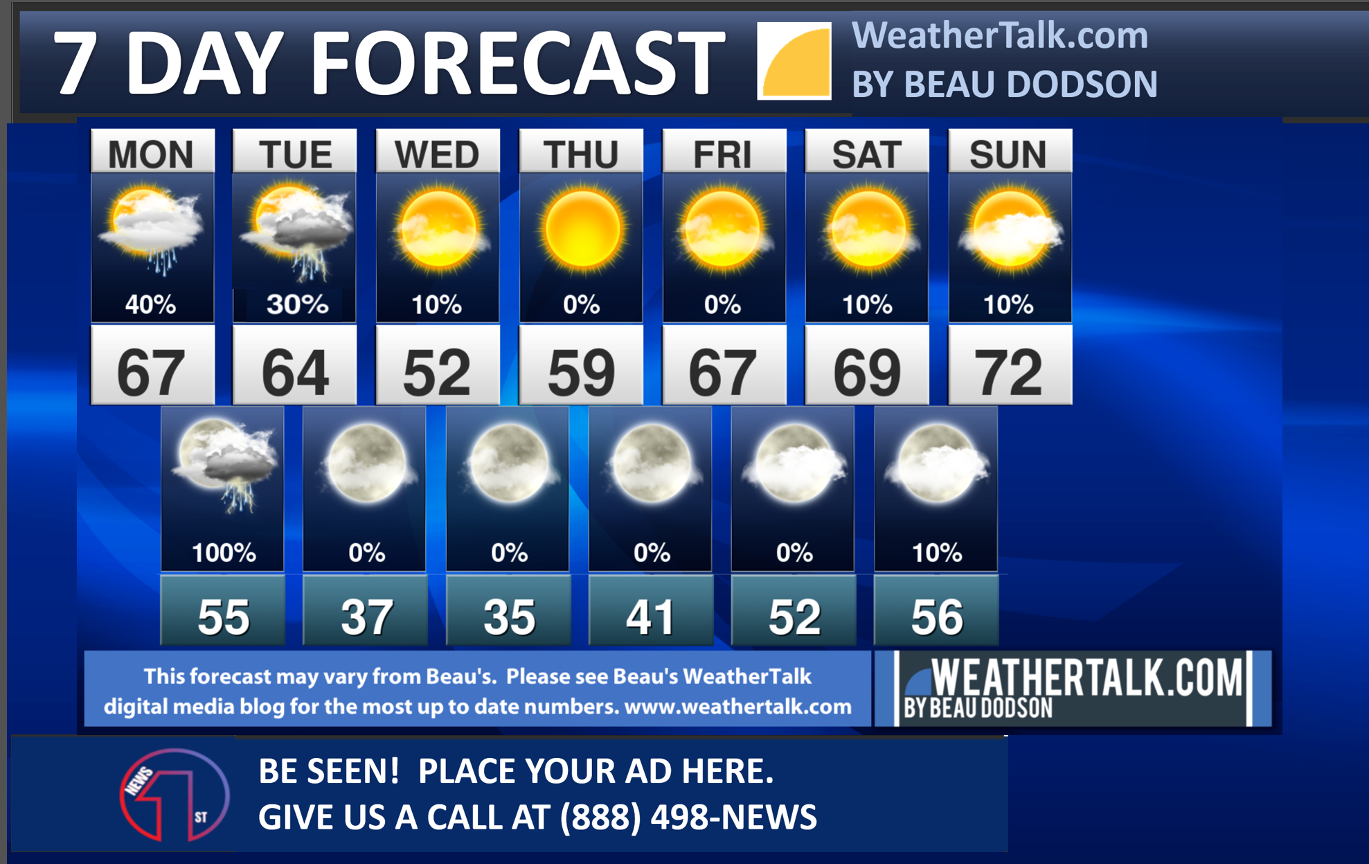
Seven-day forecast for southeast Missouri, southern Illinois, western Kentucky, and western Tennessee.
This is a BLEND for the region. Scroll down to see the region by region forecast.
48-hour forecast Graphics


.
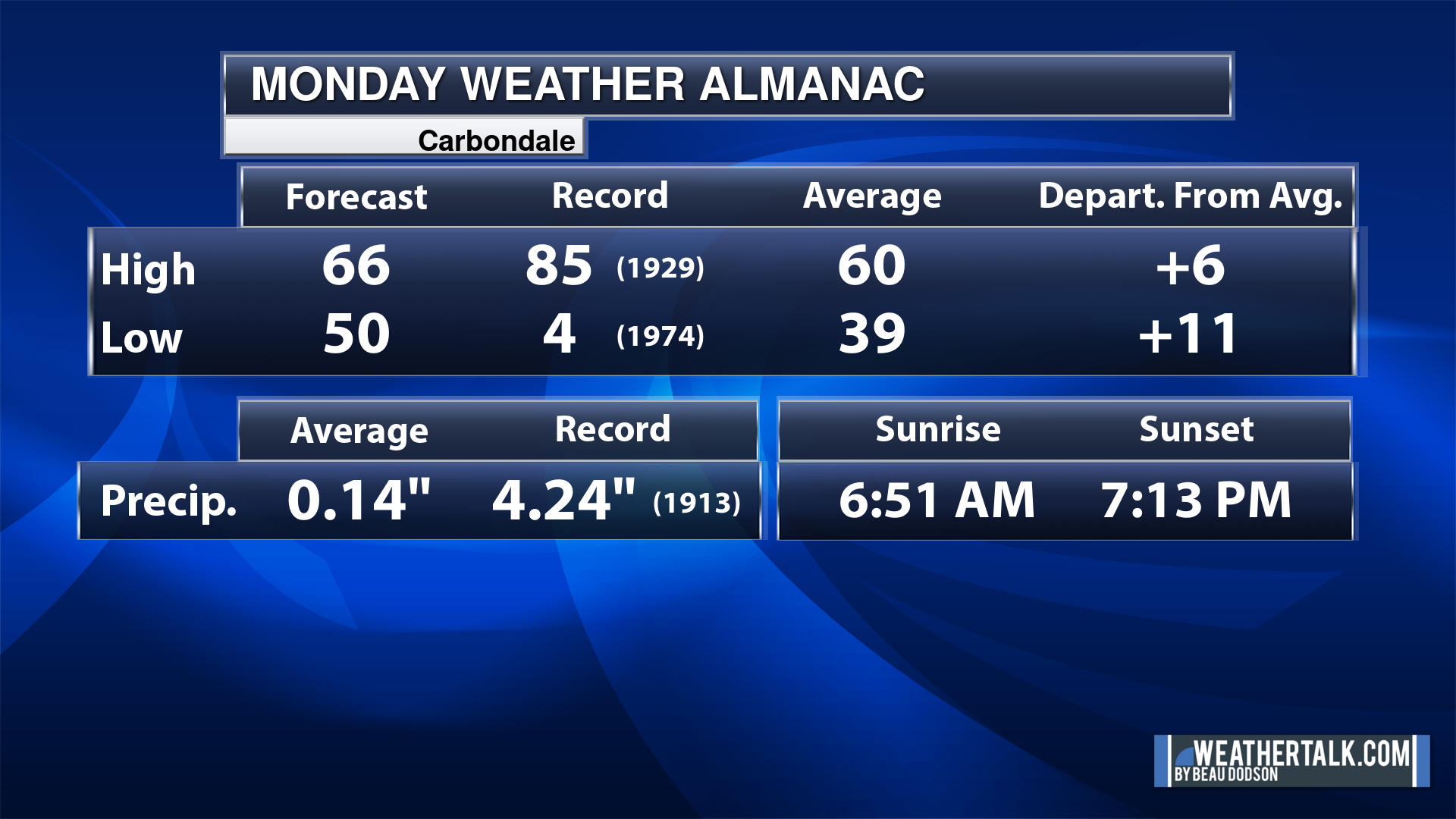
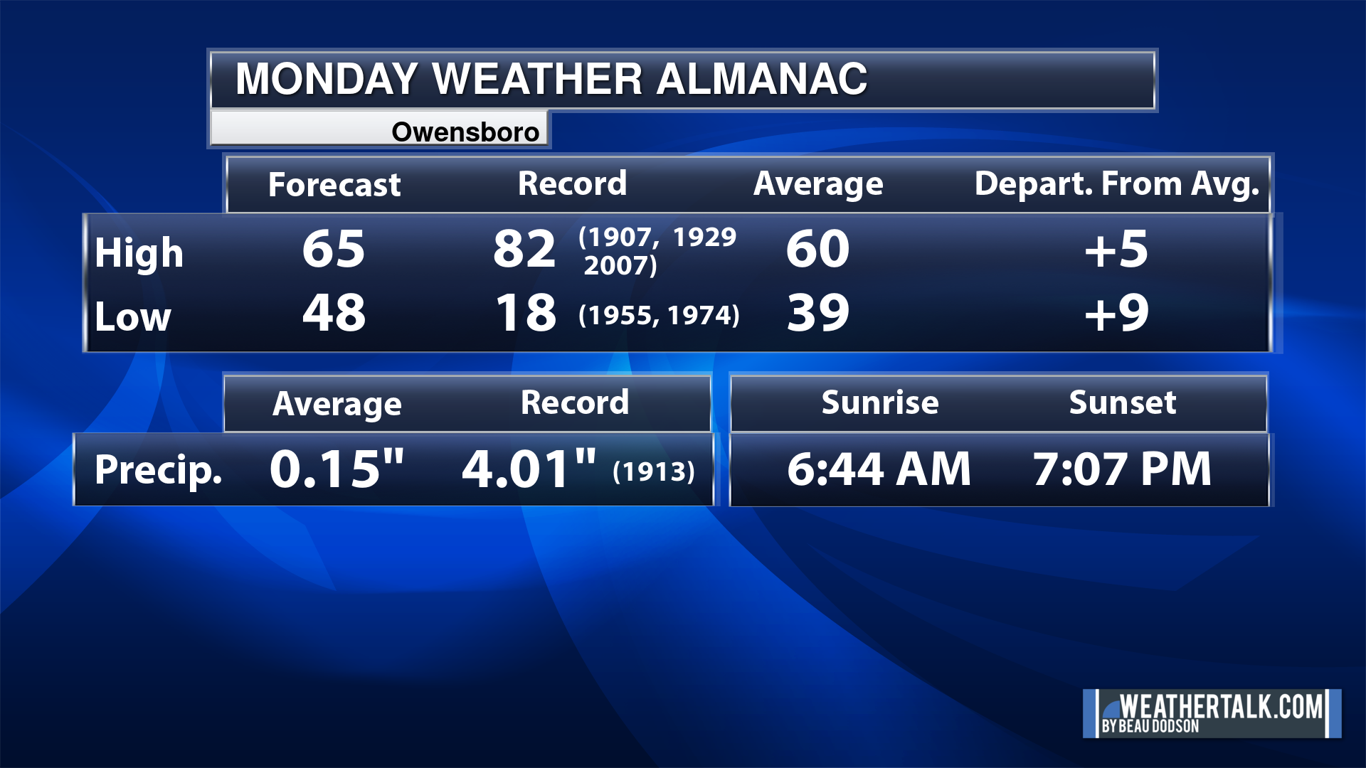
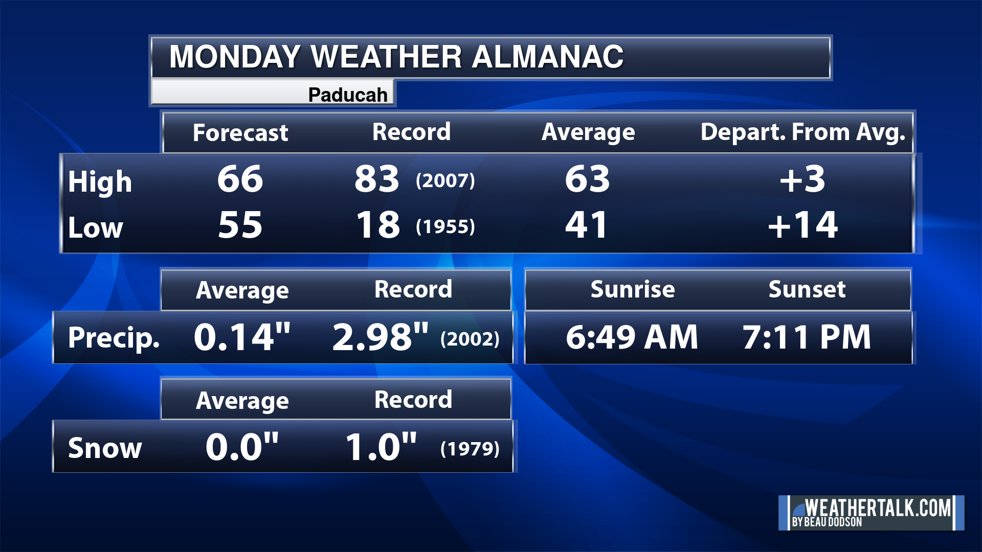
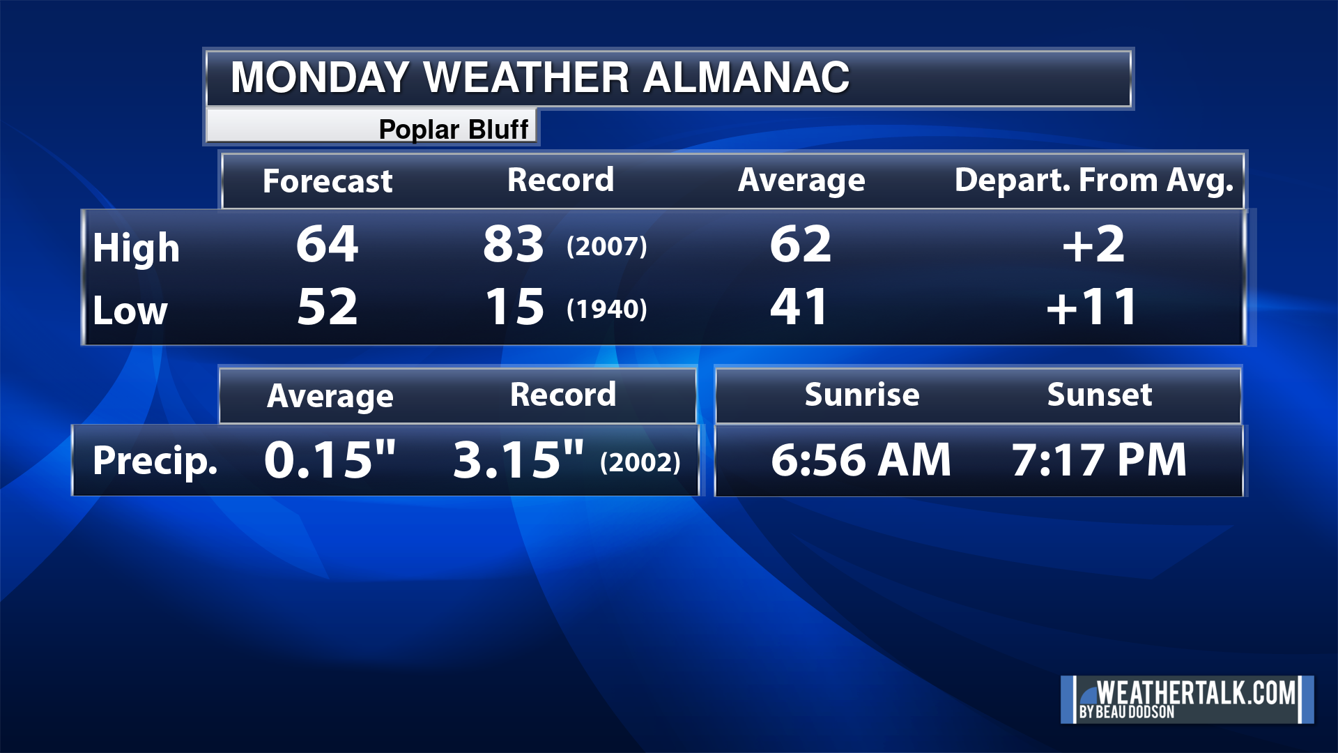
Today’s Local Almanacs (for a few select cities). Your location will be comparable.
Note, the low is this morning’s low and not tomorrows.
The forecast temperature shows you today’s expected high and this morning’s low.
The graphic shows you the record high and record low for today. It shows you what year that occurred, as well.
It then shows you what today’s average temperature is.
It shows you the departures (how may degrees above or below average temperatures will be ).
It shows you the average precipitation for today. Average comes from thirty years of rain totals.
It also shows you the record rainfall for the date and what year that occurred.
The sunrise and sunset are also shown.

![]()
.
.
Monday Forecast: Windy. Intervals of clouds. An increasing chance of showers and thunderstorms as we move into the afternoon and evening hours. Approaching from Missouri and Arkansas.
What is the chance of precipitation?
Far northern southeast Missouri ~ 70%
Southeast Missouri ~ 70%
The Missouri Bootheel ~ 70%
I-64 Corridor of southern Illinois ~ 60%
Southern Illinois ~ 60%
Extreme southern Illinois (southern seven counties) ~ 60%
Far western Kentucky (Purchase area) ~ 60%
The Pennyrile area of western KY ~ 40%
Northwest Kentucky (near Indiana border) ~ 30%
Northwest Tennessee ~ 60%
Coverage of precipitation: Numerous west. Scattered east.
Timing of the precipitation: Any given point of time, but increasing chances late afternoon and evening.
Far northern southeast Missouri ~ 62° to 65°
Southeast Missouri ~ 62° to 65°
The Missouri Bootheel ~ 62° to 65°
I-64 Corridor of southern Illinois ~ 63° to 66°
Southern Illinois ~ 64° to 66°
Extreme southern Illinois (southern seven counties) ~ 64° to 66°
Far western Kentucky ~ 64° to 68°
The Pennyrile area of western KY ~ 64° to 68°
Northwest Kentucky (near Indiana border) ~ 64° to 66°
Northwest Tennessee ~ 64° to 68°
Winds will be from this direction: South southeast 15 to 45 mph. Gusty.
Wind chill or heat index (feels like) temperature forecast: 55° to 60°
What impacts are anticipated from the weather? Wet roadways. Lightning.
Should I cancel my outdoor plans? Have a plan B and monitor the Beau Dodson Weather Radars.
UV Index: 3. Moderate.
Sunrise: 6:51 AM
Sunset: 7:12 PM
.
Monday Night Forecast: Mostly cloudy. Windy. Showers and thunderstorms.
What is the chance of precipitation?
Far northern southeast Missouri ~ 100%
Southeast Missouri ~ 100%
The Missouri Bootheel ~ 100%
I-64 Corridor of southern Illinois ~ 100%
Southern Illinois ~ 100%
Extreme southern Illinois (southern seven counties) ~ 100%
Far western Kentucky (Purchase area) ~ 100%
The Pennyrile area of western KY ~ 100%
Northwest Kentucky (near Indiana border) ~ 100%
Northwest Tennessee ~ 100%
Coverage of precipitation: Numerous
Timing of the precipitation: Any given point of time
Temperature range:
Far northern southeast Missouri ~ 44° to 46°
Southeast Missouri ~ 44° to 48°
The Missouri Bootheel ~ 46° to 50°
I-64 Corridor of southern Illinois ~ 42° to 44°
Southern Illinois ~ 43° to 46°
Extreme southern Illinois (southern seven counties) ~ 48° to 52°
Far western Kentucky ~ 48° to 52°
The Pennyrile area of western KY ~ 52° to 55°
Northwest Kentucky (near Indiana border) ~ 38° to 52°
Northwest Tennessee ~ 50° to 55°
Winds will be from this direction: Southwest becoming west 10 to 35 mph with higher gusts.
Wind chill or heat index (feels like) temperature forecast: 40° to 50°
What impacts are anticipated from the weather? Wet roadways. Lightning.
Should I cancel my outdoor plans? Have a plan B and monitor the Beau Dodson Weather Radars.
Moonrise: 7:48 PM
Moonset: 7:03 AM
The phase of the moon: Full
.
Tuesday Forecast: Morning clouds. Becoming partly sunny. A few morning showers and then perhaps a few showers and thunderstorms late morning and afternoon over mainly Kentucky.
What is the chance of precipitation?
Far northern southeast Missouri ~ 20%
Southeast Missouri ~ 20%
The Missouri Bootheel ~ 20%
I-64 Corridor of southern Illinois ~ 30%
Southern Illinois ~ 30%
Extreme southern Illinois (southern seven counties) ~ 30%
Far western Kentucky (Purchase area) ~ 30%
The Pennyrile area of western KY ~ 40%
Northwest Kentucky (near Indiana border) ~ 40%
Northwest Tennessee ~ 30%
Coverage of precipitation: Scattered
Timing of the precipitation: Before 4 PM.
Far northern southeast Missouri ~ 52° to 55°
Southeast Missouri ~ 54° to 58°
The Missouri Bootheel ~ 54° to 58°
I-64 Corridor of southern Illinois ~ 58° to 62°
Southern Illinois ~ 60° to 62°
Extreme southern Illinois (southern seven counties) ~ 62° to 64°
Far western Kentucky ~ 63° to 66°
The Pennyrile area of western KY ~ 68° to 72°
Northwest Kentucky (near Indiana border) ~ 63° to 66°
Northwest Tennessee ~ 64° to 68°
Winds will be from this direction: South southwest 15 to 30 mph. Gusty.
Wind chill or heat index (feels like) temperature forecast: 48° to 60°
What impacts are anticipated from the weather? Wet roadways. Lightning.
Should I cancel my outdoor plans? No, but monitor the Beau Dodson Weather Radars.
UV Index: 6. High.
Sunrise: 6:49 AM
Sunset: 7:13 PM
.
Tuesday Night Forecast: Clearing and colder.
What is the chance of precipitation?
Far northern southeast Missouri ~ 0%
Southeast Missouri ~ 0%
The Missouri Bootheel ~ 0%
I-64 Corridor of southern Illinois ~ 0%
Southern Illinois ~ 0%
Extreme southern Illinois (southern seven counties) ~ 0%
Far western Kentucky (Purchase area) ~ 0%
The Pennyrile area of western KY ~ 0%
Northwest Kentucky (near Indiana border) ~ 0%
Northwest Tennessee ~ 0%
Coverage of precipitation:
Timing of the precipitation:
Temperature range:
Far northern southeast Missouri ~ 30° to 32°
Southeast Missouri ~ 33° to 36°
The Missouri Bootheel ~ 36° to 38°
I-64 Corridor of southern Illinois ~ 30° to 32°
Southern Illinois ~ 32° to 34°
Extreme southern Illinois (southern seven counties) ~ 33° to 36°
Far western Kentucky ~ 34° to 38°
The Pennyrile area of western KY ~ 34° to 38°
Northwest Kentucky (near Indiana border) ~ 34° to 38°
Northwest Tennessee ~ 34° to 38°
Winds will be from this direction: West northwest 7 to 14 mph
Wind chill or heat index (feels like) temperature forecast: 28° to 38°
What impacts are anticipated from the weather?
Should I cancel my outdoor plans? No
Moonrise: 8:48 PM
Moonset: 7:24 AM
The phase of the moon: Waning Gibbous
.
Wednesday Forecast: Mostly sunny.
What is the chance of precipitation?
Far northern southeast Missouri ~ 0%
Southeast Missouri ~ 0%
The Missouri Bootheel ~ 0%
I-64 Corridor of southern Illinois ~ 0%
Southern Illinois ~ 0%
Extreme southern Illinois (southern seven counties) ~ 0%
Far western Kentucky (Purchase area) ~ 0%
The Pennyrile area of western KY ~ 0%
Northwest Kentucky (near Indiana border) ~ 0%
Northwest Tennessee ~ 0%
Coverage of precipitation:
Timing of the precipitation:
Far northern southeast Missouri ~ 55° to 58°
Southeast Missouri ~ 55° to 58°
The Missouri Bootheel ~ 56° to 58°
I-64 Corridor of southern Illinois ~ 55° to 58°
Southern Illinois ~ 55° to 58°
Extreme southern Illinois (southern seven counties) ~ 56° to 58°
Far western Kentucky ~ 56° to 60°
The Pennyrile area of western KY ~ 56° to 60°
Northwest Kentucky (near Indiana border) ~ 56° to 60°
Northwest Tennessee ~ 60° to 62°
Winds will be from this direction: Northwest 7 to 14 mph
Wind chill or heat index (feels like) temperature forecast: 52° to 58°
What impacts are anticipated from the weather?
Should I cancel my outdoor plans? No
UV Index: 7. High.
Sunrise: 6:48 AM
Sunset: 7:14 PM
.
Wednesday Night Forecast: Mostly clear.
What is the chance of precipitation?
Far northern southeast Missouri ~ 0%
Southeast Missouri ~ 0%
The Missouri Bootheel ~ 0%
I-64 Corridor of southern Illinois ~ 0%
Southern Illinois ~ 0%
Extreme southern Illinois (southern seven counties) ~ 0%
Far western Kentucky (Purchase area) ~ 0%
The Pennyrile area of western KY ~ 0%
Northwest Kentucky (near Indiana border) ~ 0%
Northwest Tennessee ~ 0%
Coverage of precipitation:
Timing of the precipitation:
Temperature range:
Far northern southeast Missouri ~ 28° to 32°
Southeast Missouri ~ 32° to 34°
The Missouri Bootheel ~ 32° to 35°
I-64 Corridor of southern Illinois ~ 28° to 32°
Southern Illinois ~ 30° to 34°
Extreme southern Illinois (southern seven counties) ~ 32° to 34°
Far western Kentucky ~ 32° to 34°
The Pennyrile area of western KY ~ 32° to 34°
Northwest Kentucky (near Indiana border) ~ 32° to 34°
Northwest Tennessee ~ 33° to 36°
Winds will be from this direction: North 6 to 12 mph
Wind chill or heat index (feels like) temperature forecast: 26° to 34°
What impacts are anticipated from the weather?
Should I cancel my outdoor plans? No
Moonrise: 9:47 PM
Moonset: 7:47 AM
The phase of the moon: Waning Gibbous
.
Click here if you would like to return to the top of the page.

-
- Windy today and tonight.
- A few showers today.
- Showers and thunderstorms likely tonight into tomorrow morning.
- A second line of storms possible tomorrow over mainly Indiana and Kentucky.
- Chilly temperatures for several nights this week. Watch for frost and a light freeze (for some).
- Watching shower and thunderstorm chances Easter into next Monday.
Weather advice:
Do you have any suggestions or comments? Email me at beaudodson@usawx.com
Make sure you have three to five ways of receiving your severe weather information.
.
Beau’s Forecast Discussion
Good day, everyone.

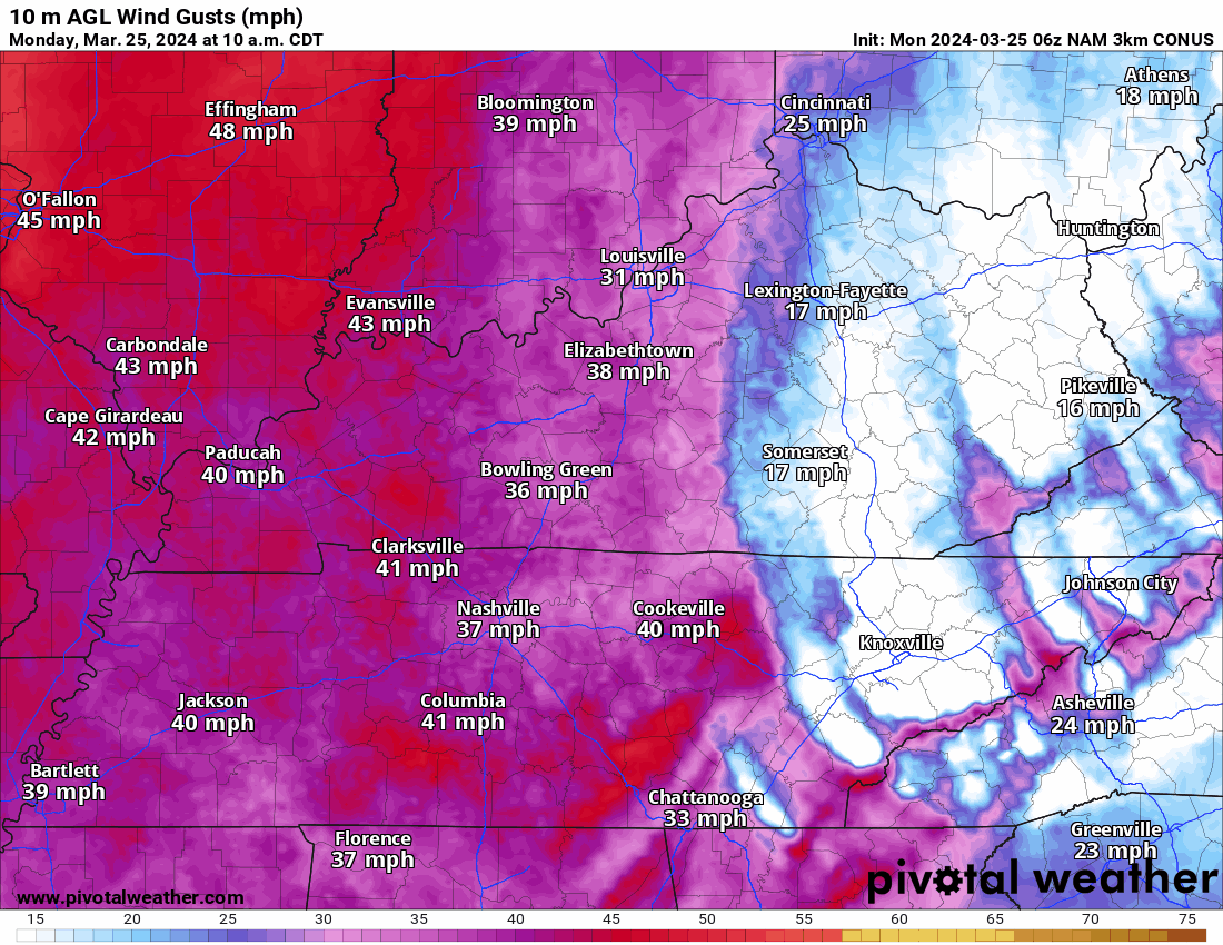
We have a windy day ahead of us.
Southerly winds of 25 to 40 mph will be common. Occasional gusts above 40 mph will be possible.
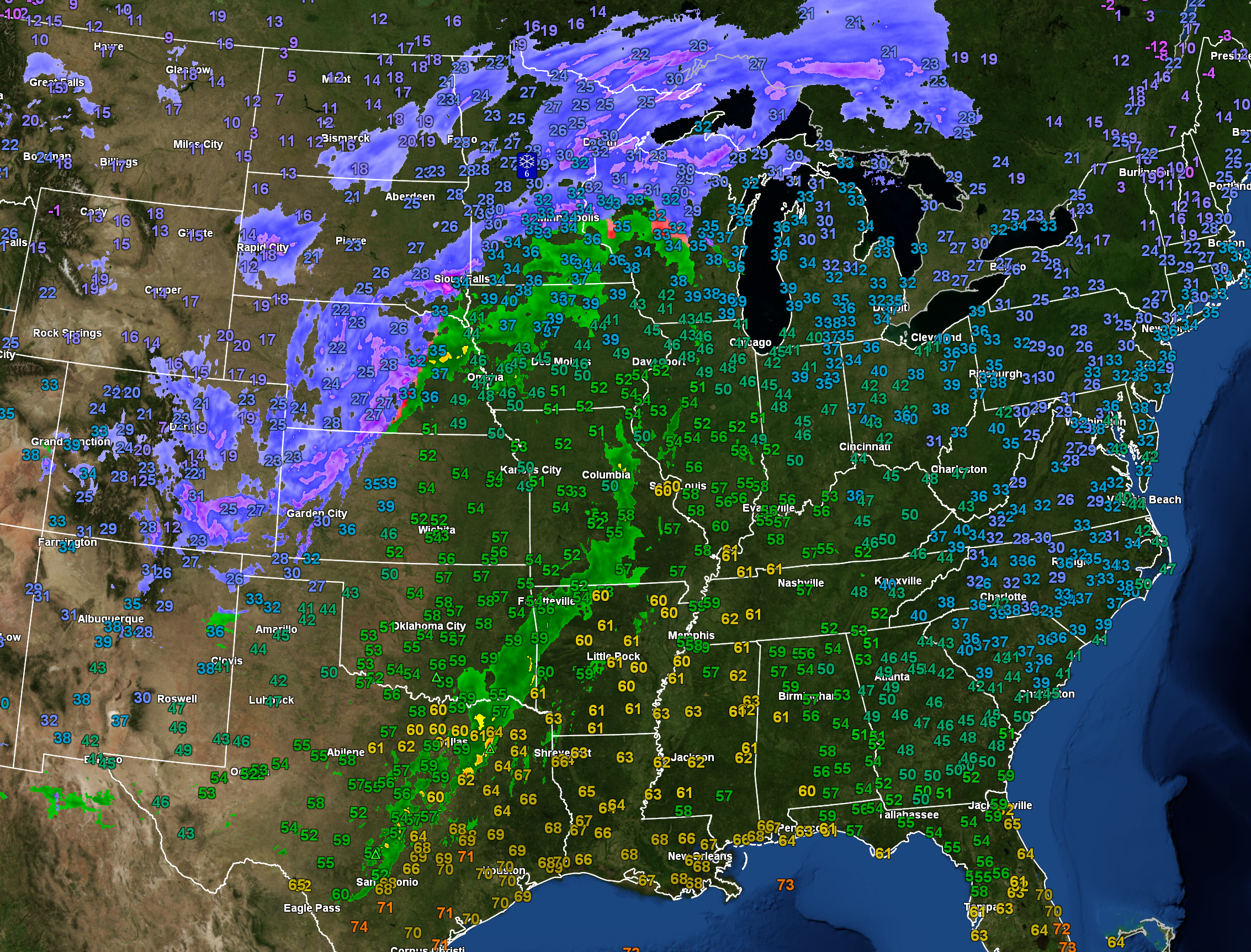
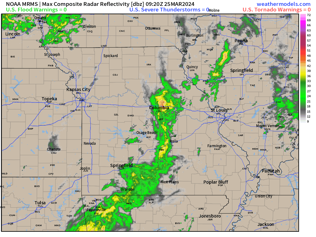
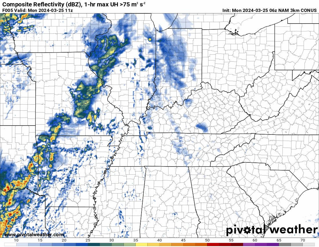
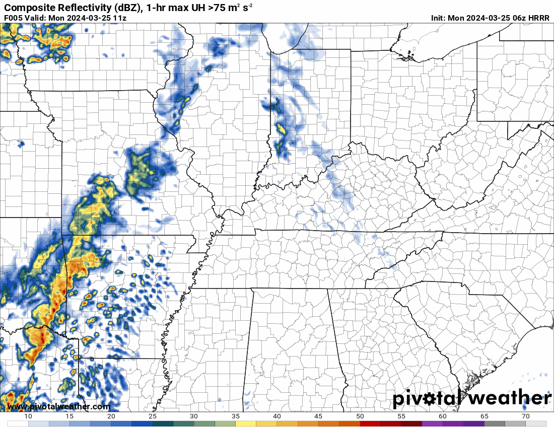
First, let’s look at radar. You can see the storm system to our west. Widespread showers and thunderstorms. Widespread snow from Canada to Mexico.
Blue and purple represent snow. Green would be the rain.
Locally, we don’t have to worry about snow, thankfully.
We will, however, have showers and thunderstorms developing from west to east.
Precipitation coverage will increase this afternoon into tonight.
Double click images to enlarge them.
6 AM radar animation. What radar was showing at 6 am.
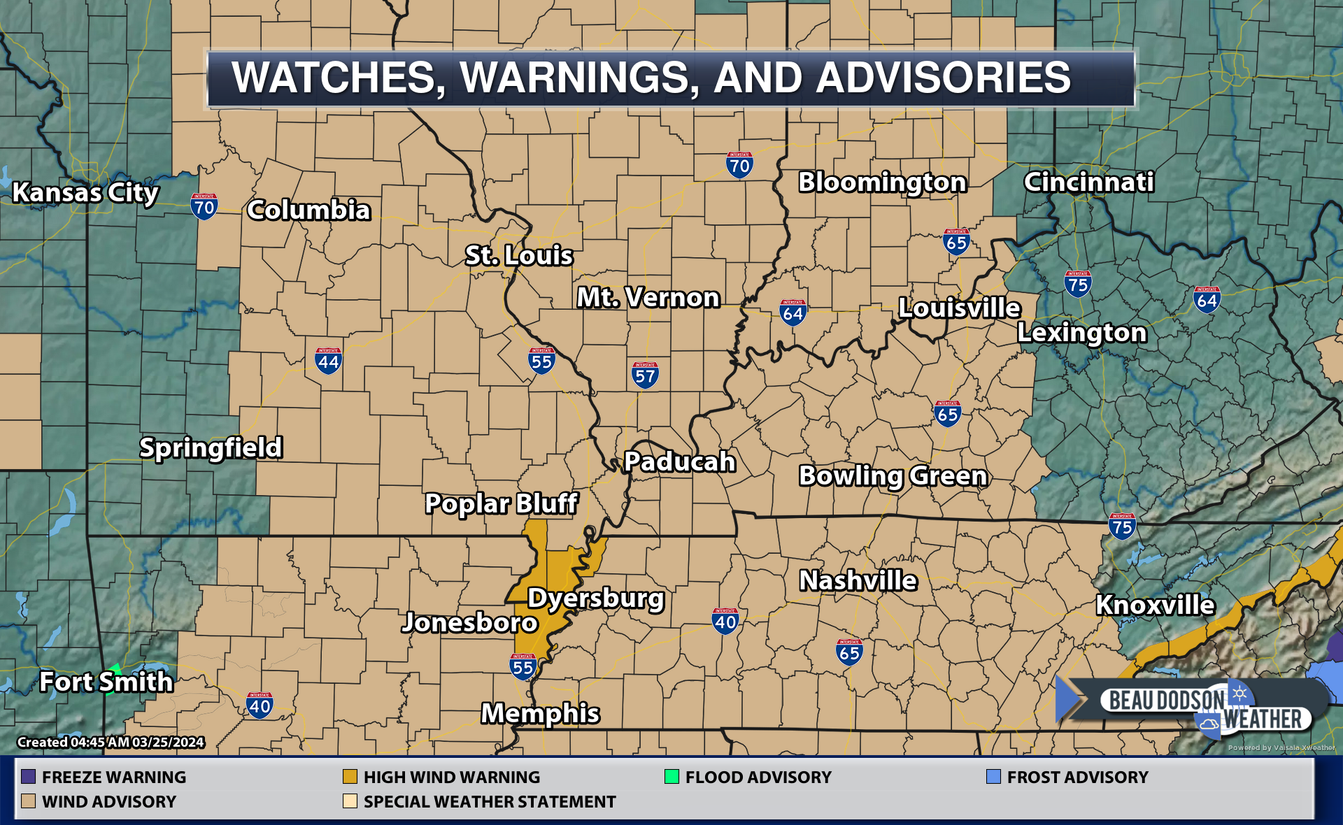
A wind advisory blankets the region. A high wind warning for the Bootheel and a small portion of northwest Tennessee.
The high warning is where winds could gust above 50 mph!
Here is the NAM model showing wind gusts and timing. The time is in Zulu.
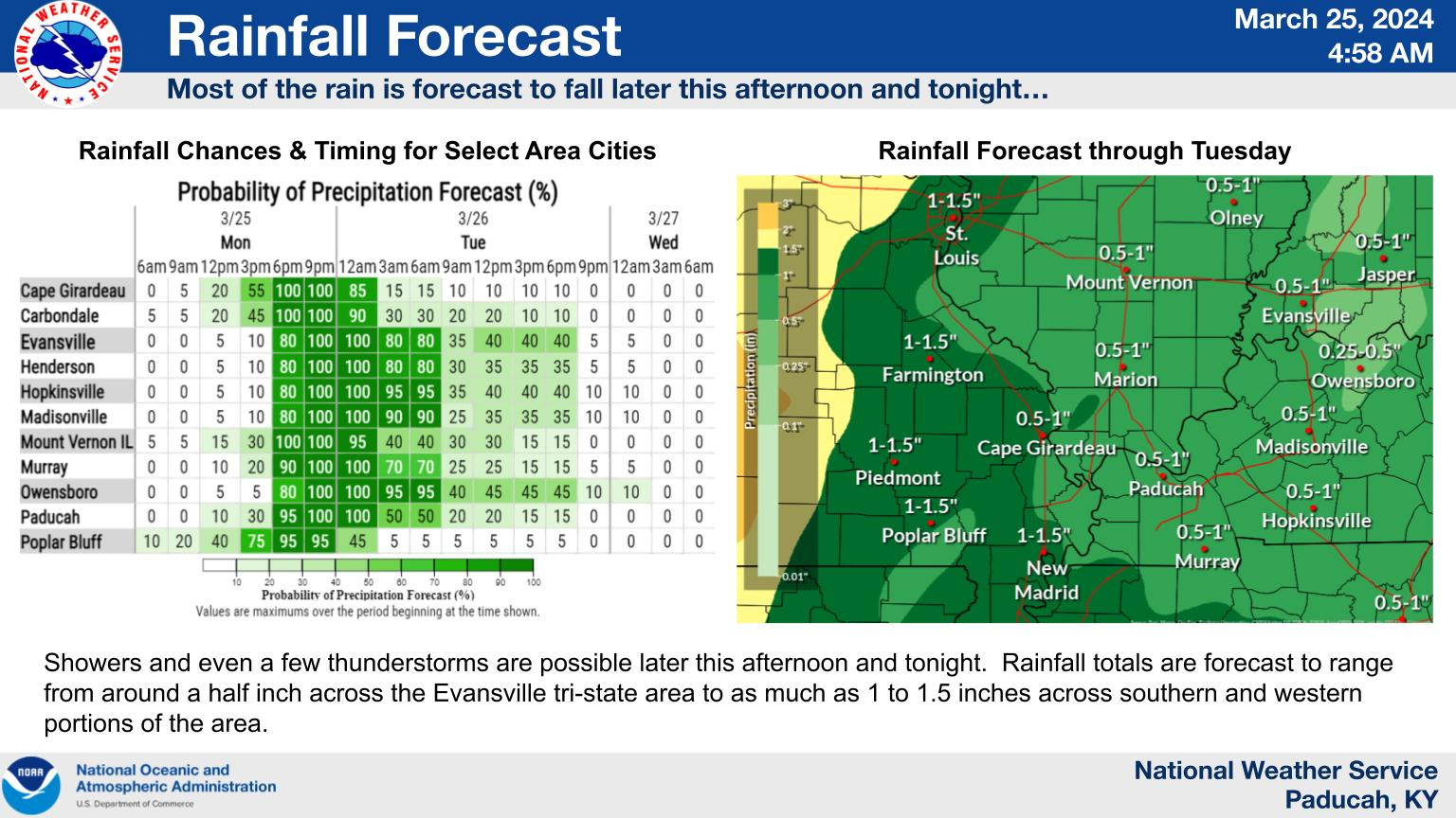
Rainfall totals
This graphic is from the Paducah, Kentucky NWS.
Double click images to enlarge them.
Here is the WPC NOAA rainfall outlook.
Double click images to enlarge them.
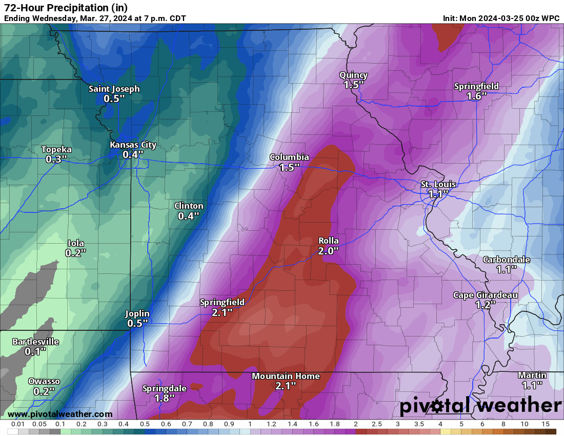
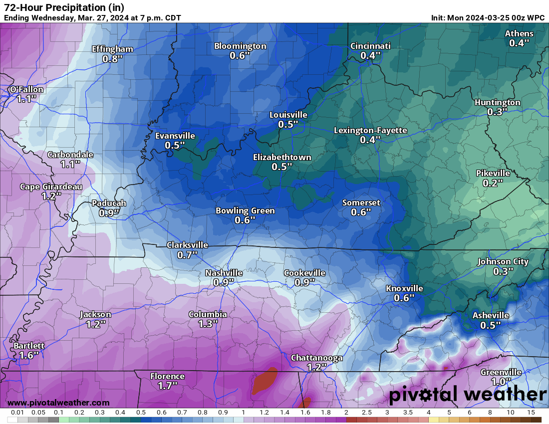
We need rain. We are still in drought.
A few of the thunderstorms could be strong this afternoon and evening. Perhaps bringing down some gusty winds. Brief heavy rain and lightning, as well. I can’t rule out a severe thunderstorm warning.
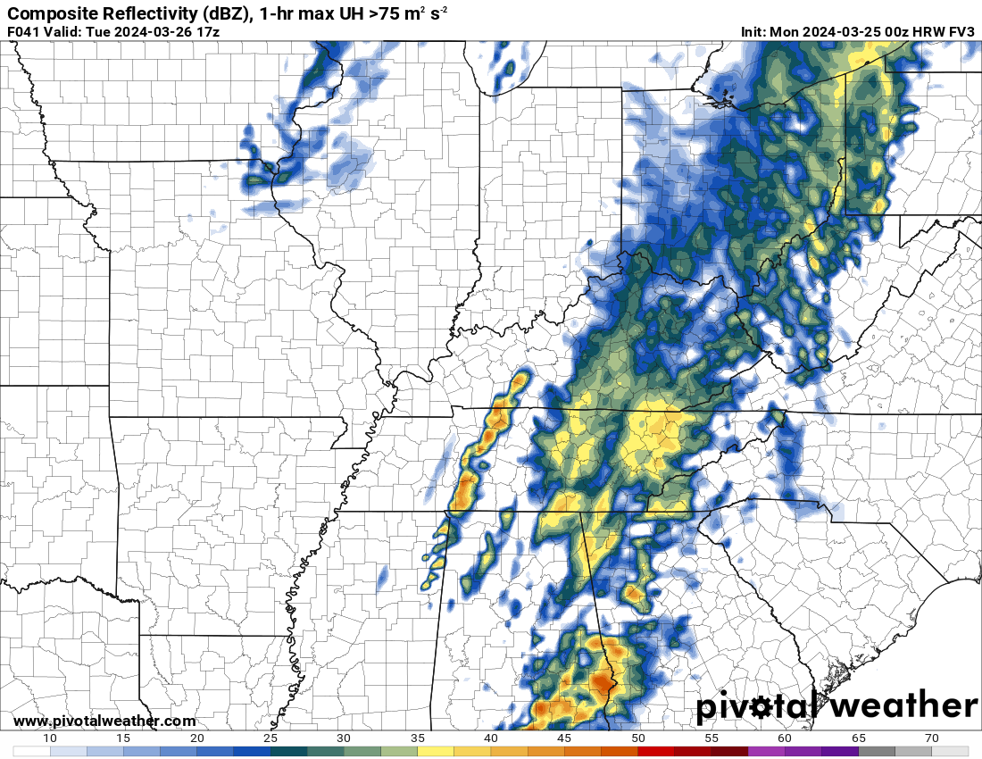
On Tuesday, a second line of storms is forecast to form over portions of Indiana and Kentucky. If the front speeds up, then my area won’t be impacted by this. I will need to monitor it.
That line of storms could produce a few reports of hail and damaging wind.
The Storm Prediction Center has a level one risk for portions of northwest Kentucky Tuesday late morning into the afternoon hours.
Let’s look at a couple of models concerning the Tuesday storms.
These first two models show the line forming to the east of my forecast area.
I will keep an eye on it.
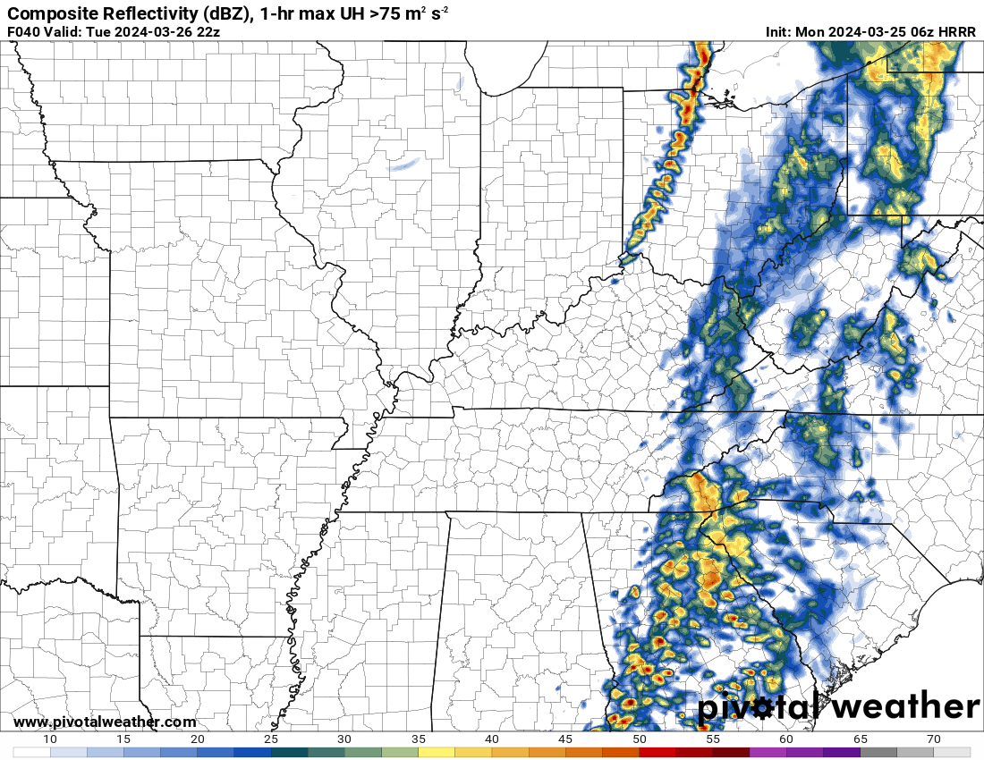
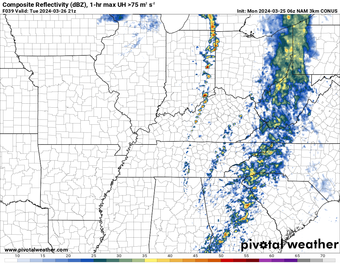
This last one shows it forming in south central Kentucky down into Tennessee.
All data shows Tuesday’s event being fairly far east.
Conditions dry out Tuesday from west to east.
The bulk of this rain event is this afternoon and tonight.
It will be chilly Tuesday and Wednesday night. I can’t rule out frost if the wind subsides.
Lows will dip into the 30s both nights.
A slow warming trend Thursday into the weekend.
I am watching another storm system Sunday into Monday with perhaps some showers and thunderstorms.
Highs Friday into Monday are likely to rise into the 70s. Perhaps mid 70s for the weekend with lows in the 50s.
![]()
.
Click here if you would like to return to the top of the page.
This outlook covers southeast Missouri, southern Illinois, western Kentucky, and far northwest Tennessee.

.
Today’s Storm Prediction Center’s (SPC) Severe Weather Outlook
Light green is where thunderstorms may occur but should be below severe levels.
Dark green is a level one risk. Yellow is a level two risk. Orange is a level three (enhanced) risk. Red is a level four (moderate) risk. Pink is a level five (high) risk.
One is the lowest risk. Five is the highest risk.
A severe storm is one that produces 58 mph wind or higher, quarter or larger size hail, and/or a tornado.
Explanation of tables. Click here.
Day One Severe Weather Outlook

Day One Severe Weather Outlook. Zoomed in on our region.

.
Day One Tornado Probability Outlook

Day One Regional Tornado Outlook. Zoomed in on our region.

.
Day One Large Hail Probability Outlook

Day One Regional Hail Outlook. Zoomed in on our region.

.
Day One High wind Probability Outlook

Day One Regional Wind Outlook. Zoomed in on our region.

.
Tomorrow’s severe weather outlook. Day two outlook.

Day Two Outlook. Zoomed in on our region.

.
Day Three Severe Weather Outlook

.

.
The images below are from NOAA’s Weather Prediction Center.
24-hour precipitation outlook..
 .
.
.
48-hour precipitation outlook.
. .
.
![]()
_______________________________________
.

Click here if you would like to return to the top of the page.
Again, as a reminder, these are models. They are never 100% accurate. Take the general idea from them.
What should I take from these?
- The general idea and not specifics. Models usually do well with the generalities.
- The time-stamp is located in the upper left corner.
.
What am I looking at?
You are looking at computer model data. Meteorologists use many different models to forecast the weather.
Occasionally, these maps are in Zulu time. 12z=7 AM. 18z=1 PM. 00z=7 PM. 06z=1 AM
Green represents light rain. Dark green represents moderate rain. Yellow and orange represent heavier rain.
.
This animation is the FVS Model.
Occasionally, these maps are in Zulu time. 12z=7 AM. 18z=1 PM. 00z=7 PM. 06z=1 AM
Double click images to enlarge them. Blue is snow. Pink is a wintry mix. Green is rain.
.
This animation is the NAM Model.
Occasionally, these maps are in Zulu time. 12z=7 AM. 18z=1 PM. 00z=7 PM. 06z=1 AM
Double click images to enlarge them.
.
This animation is the HRRR Model.
Green is rain. Yellow and orange are heavier rain. Pink is a wintry mix. Blue is snow. Dark blue is heavier snow.
Occasionally, these maps are in Zulu time. 12z=7 AM. 18z=1 PM. 00z=7 PM. 06z=1 AM
Double click images to enlarge them.
.
This animation is the GFS Model.
Green is rain. Yellow and orange are heavier rain. Pink is a wintry mix. Blue is snow. Dark blue is heavier snow.
Occasionally, these maps are in Zulu time. 12z=7 AM. 18z=1 PM. 00z=7 PM. 06z=1 AM
Double click images to enlarge them.
.
This animation is the EC Model.
Green is rain. Yellow and orange are heavier rain. Pink is a wintry mix. Blue is snow. Dark blue is heavier snow.
Occasionally, these maps are in Zulu time. 12z=7 AM. 18z=1 PM. 00z=7 PM. 06z=1 AM
Double click images to enlarge them.
..![]()

.
Click here if you would like to return to the top of the page.
.Average high temperatures for this time of the year are around 62 degrees.
Average low temperatures for this time of the year are around 40 degrees.
Average precipitation during this time period ranges from 0.60″ to 1.20″
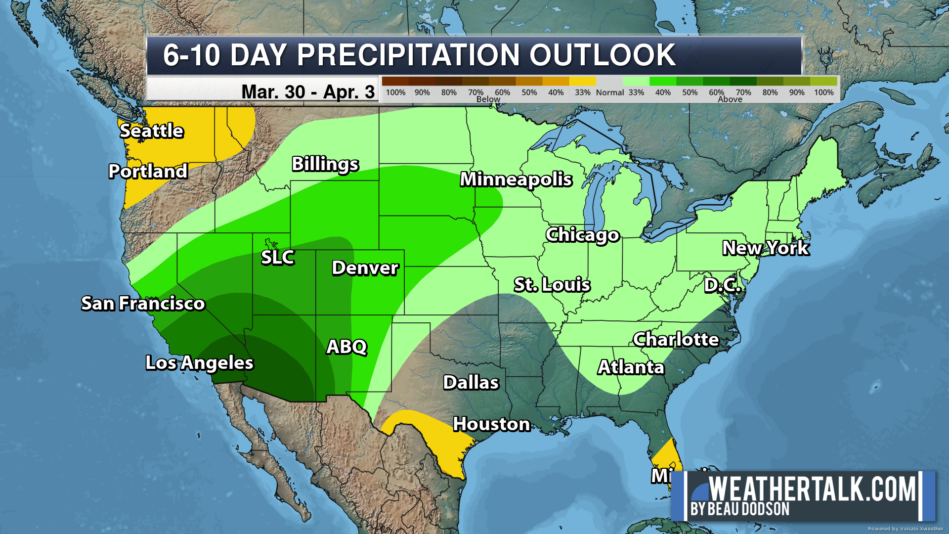
Six to Ten Day Outlook.
Blue is below average. Red is above average. The no color zone represents equal chances.
Average highs for this time of the year are in the lower 60s. Average lows for this time of the year are in the lower 40s.
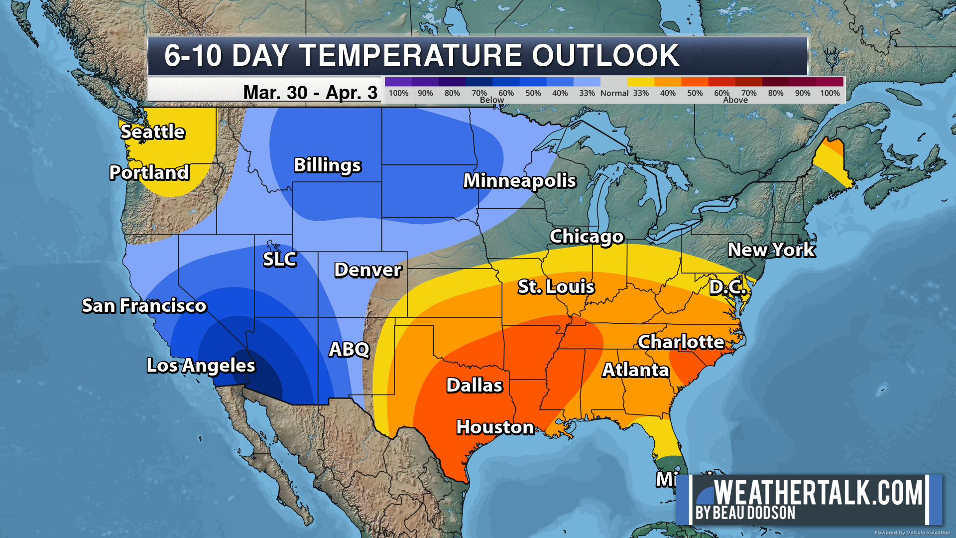
Green is above average precipitation. Yellow and brown favors below average precipitation. Average precipitation for this time of the year is around one inch per week.
.

Average low temperatures for this time of the year are around 41 degrees.
Average precipitation during this time period ranges from 0.60″ to 1.20″
.
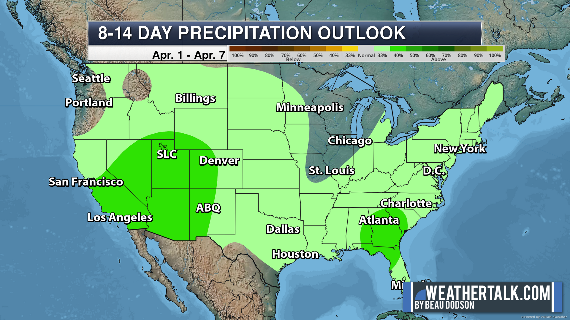
Eight to Fourteen Day Outlook.
Blue is below average. Red is above average. The no color zone represents equal chances.
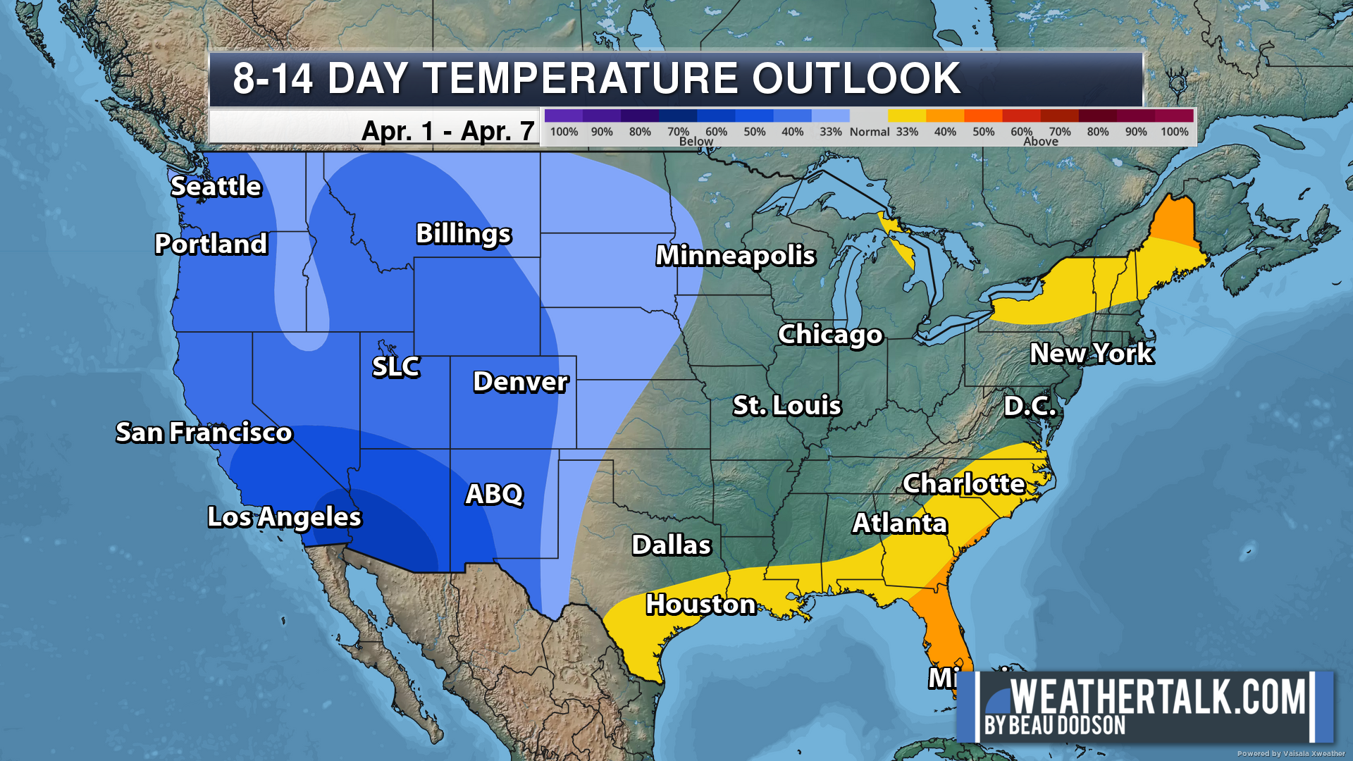
Green is above average precipitation. Yellow and brown favors below average precipitation. Average precipitation for this time of the year is around one inch per week.
.
![]()
The app is for subscribers. Subscribe at www.weathertalk.com/welcome then go to your app store and search for WeatherTalk
Subscribers, PLEASE USE THE APP. ATT and Verizon are not reliable during severe weather. They are delaying text messages.
The app is under WeatherTalk in the app store.

Apple users click here

Android users click here
.

Radars and Lightning Data
Interactive-city-view radars. Clickable watches and warnings.
https://wtalk.co/B3XHASFZ
If the radar is not updating then try another one. If a radar does not appear to be refreshing then hit Ctrl F5. You may also try restarting your browser.
Backup radar site in case the above one is not working.
https://weathertalk.com/morani
Regional Radar
https://imagery.weathertalk.com/prx/RadarLoop.mp4
** NEW ** Zoom radar with chaser tracking abilities!
ZoomRadar
Lightning Data (zoom in and out of your local area)
https://wtalk.co/WJ3SN5UZ
Not working? Email me at beaudodson@usawx.com
National map of weather watches and warnings. Click here.
Storm Prediction Center. Click here.
Weather Prediction Center. Click here.
.

Live lightning data: Click here.
Real time lightning data (another one) https://map.blitzortung.org/#5.02/37.95/-86.99
Our new Zoom radar with storm chases
.
.

Interactive GOES R satellite. Track clouds. Click here.
GOES 16 slider tool. Click here.
College of DuPage satellites. Click here
.

Here are the latest local river stage forecast numbers Click Here.
Here are the latest lake stage forecast numbers for Kentucky Lake and Lake Barkley Click Here.
.
.
Find Beau on Facebook! Click the banner.


 .
.