We have some great sponsors for the Weather Talk Blog. Please support them when you have the opportunity.
Milner and Orr Funeral Home and Cremation Services located in Paducah, Kentucky and three other western Kentucky towns – at Milner and Orr they believe in families helping families. You can find Milner and Orr on Facebook, as well.
![]()

This forecast update covers far southern Illinois, far southeast Missouri, and far western Kentucky. See the coverage map on the right side of the blog.
Remember that weather evolves. Check back frequently for updates, especially during active weather.
The forecast numbers below may vary quite a bit across the region. These are averages.
Thursday – Cloudy. Some morning showers. There was some flooding overnight in some counties. Avoid flooded roadways. It will be cooler today and damp. Temperatures will mostly be in the 40’s to lower 50’s. North/northwest winds at 10-20 mph. My confidence in this part of the forecast verifying is high
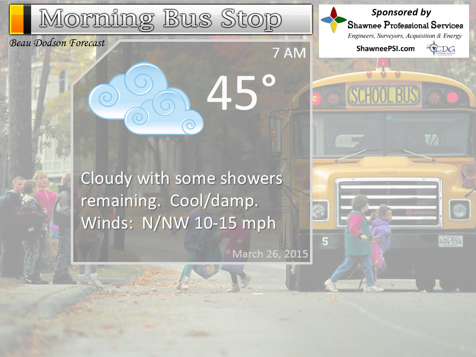
Morning School Bus Stop Weather – Cloudy with some showers. Cool. Damp. North/northwest winds at 10-15 mph. Temperatures mainly in the 40’s.
—————————————————————————————-
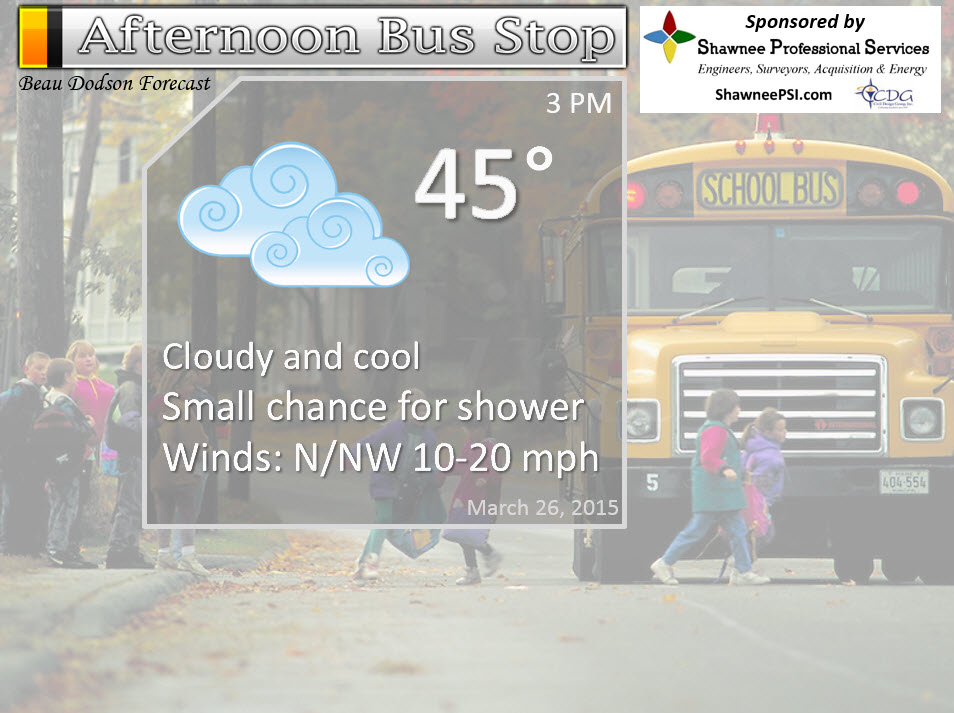
Afternoon School Bus Stop Weather – Cloudy. Small chance for a remaining shower. Cool/damp. Temperatures holding in the 40’s. Gusty north/northwest winds at 10-20 mph.
Thursday night – Partly cloudy and cold. Temperatures will drop into the 30’s. Northerly winds at 10 mph. My confidence in this part of the forecast verifying is medium
Friday – A mix of sun and clouds. Small chance for precipitation. Cold. Highs in the upper 30’s to mid 40’s. Northwest winds at 5-10 mph. My confidence in this part of the forecast verifying is medium
Friday night – Some clouds. Small chance for precipitation – perhaps a little better chance over southeast Missouri. Rain or rain/snow – light. Lows in the 20’s. Light winds. My confidence in this part of the forecast verifying is medium
Saturday – Cold morning. A freeze possible. A chance for light rain or snow over mainly southeast Missouri. Becoming partly cloudy. Highs in the 40’s. My confidence in this part of the forecast verifying is low

The School Bus Stop Forecast is brought to your by Shawnee Professional Services. For more information click here
Current Temperatures Around The Local Area


Don’t forget to check out the Southern Illinois Weather Observatory web-site for weather maps, tower cams, scanner feeds, radars, and much more! Click here

An explanation of what is happening in the atmosphere over the coming days…
Highlights
1. Rain will come to an end later today. Turning colder.
2. Colder over the next few days – frost and freeze conditions likely over the coming days. We could experience temperatures into the 20’s by Saturday morning. Sensitive plants may need protecting.
3. Weal weather system on Friday night and Saturday morning will bring a chance for light rain or light snow to mainly southeast Missouri.
3. Temperature start to rebound by Sunday
Shorter than usual update today because I had to work the severe weather event last night. It is 1 am right now, still working.
If you aren’t aware…I run now-cast threads on Facebook. Those are live question and answer threads. I monitor them continuously and answer your questions. You can always find me there during a severe weather event.
Example – this is last nights thread (you can get a feel for what type of information I post for you)
Last night’s severe weather thread – click here
Here is a satellite view of the storms yesterday evening. This is around the time Moore, Oklahoma was experiencing a tornado. The risk for severe weather was greater out there. Seems like poor Moore, Oklahoma is hit by tornadoes all the time.
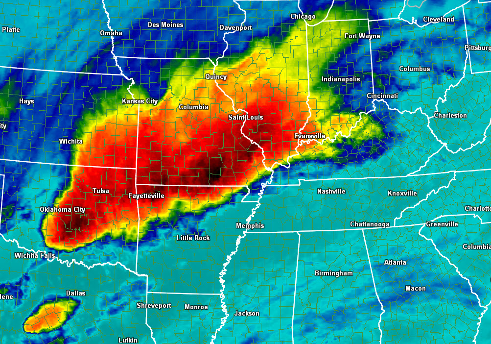
Somewhat calmer weather will prevail today. We still have lingering rain to deal with this morning and perhaps into the afternoon for some counties.
There was a lot of rain last night in the region. Rainfall totals of 1-3″ in some counties. This has caused streams to rise and ditches to overflow. Some flash flood warnings were issued overnight. Avoid flooded roadways.
Waters will reside today into bigger streams. Some additional larger stream and river rises are possible.
Most rivers have crested or are at crest. They will fall rapidly over the coming days. See the river stage graphs below (click the link for other locations, as well)
Temperatures are going to be colder over the coming days. We may have to deal with patchy frost during the overnight hours and even freeze conditions on Saturday morning. I suspect some locations will dip into the 20’s.
Cold for late March! No doubt about it.
A few weak disturbances will pass through the area, as well. A small chance for light rain or snow with the passing of the disturbances. Not a big deal, but of interest. Somebody could see a snowflake in the area.
Perhaps the best chance will be Friday night and Saturday morning. Data brings precipitation in from the north/northwest. This might be a southeast Missouri event. Light rain and light snow. Should not be a big deal, but some people in the area might pick up a little bit of precipitation.
I will try to have a longer update for you later tonight (Thursday night).
Radars
WEATHER RADAR PAGE – Click here —
I also set up a storm tracking page with additional links (use during active weather for quick reference)
Storm Tracking Tool Page
Don’t forget to support our sponsors!
Check out our sponsors! There are more on the right side bar of the page, as well. Be sure and let them know that you appreciate their sponsorship of the WeatherTalk daily weather bulletin.
How about a $5 meal deal? The DQ Grill and Chill (located across from Noble Park in Paducah, Kentucky) is the newest WeatherTalk Blog sponsor! A local business helping to sponsor the weather information that you have come to love so much.
Check out their Facebook page for specials, as well DQ Grill and Chill on Facebook


Premier Portable Buildings proudly serving our region. For more information click the above ad or here
They can also be found on this Facebook page
G&C Multi-Services out of Paducah, Kentucky. G & C Multi-Services is a service provider in Western Kentucky that provides industrial and commercial equipment fabrication, machine troubleshooting, repair and maintenance, and installation. They can custom fabricate steel, stainless, and aluminum products per customer specifications.
Visit their web-site here. Or click the ad below! Facebook page.


Wortham Dental Care located in Paducah, Kentucky. The gentle dentist. Mercury free dentistry. They also do safe Mercury removal. You can find Wortham Dental Care on Facebook, as well

Trover’s Equipment and Lawn Care – Family owned and operated! They are a dealer for Snapper, Simplicity, Snapper Pro, Bad Boy Mowers, and Intimidator Utility Vehicles. They are a Stihl and Dolmar power products dealer. They also are a dealer for Briggs & Stratton, Kohler gas & diesel engines, and Kawasaki engines. They service and repair just about any brand. You can find them on Facebook, as well
The School Bus Stop Forecast is brought to your by Shawnee Professional Services. For more information click here

Shawnee Professional Services & Civil Design Group have been providing Land Surveying, Engineering, Grant Administration and Acquisition services for the past 20 years. Currently Licensed in Illinois, Kentucky, Missouri, Indiana, and Tennessee; please contact Shawnee for any Land Surveying or Engineering needs. Shawnee’s company size allows them to devote individual attention to each client and to approach each project with the required thoroughness to successfully complete the project, large or small. Visit Shawnee’s website at shawneepsi.com for more information. Shawnee has offices in Paducah, KY, Vienna, IL and Benton, IL.
.

Here are the current river stage forecasts. You can click your state and then the dot for your location. It will bring up the full forecast and hydrograph.
Click Here For River Stage Forecasts…
Here are some current forecast hydrographs. These will be updated each day with new information.


Smithland Lock and Dam

Paducah, Kentucky Forecast Stage

Cairo, Illinois

We have regional radars and local city radars – if a radar does not seem to be updating then try another one. Occasional browsers need their cache cleared. You may also try restarting your browser. That usually fixes the problem. Occasionally we do have a radar go down. That is why I have duplicates. Thus, if one fails then try another one.
If you have any problems then please send me an email beaudodson@usawx.com
WEATHER RADAR PAGE – Click here —
We also have a new national interactive radar – you can view that radar by clicking here.
Local interactive city radars include St Louis, Mt Vernon, Evansville, Poplar Bluff, Cape Girardeau, Marion, Paducah, Hopkinsville, Memphis, Nashville, Dyersburg, and all of eastern Kentucky – these are interactive radars. Local city radars – click here
NOTE: Occasionally you will see ground clutter on the radar (these are false echoes). Normally they show up close to the radar sites – including Paducah.

Regional Radar – Click on radar to take you our full radar page.


Regional Radar

Live Lightning Data – zoom and pan: Click here
Live Lightning Data with sound (click the sound button on the left side of the page): Click here
![]()
Current WARNINGS (a warning means take action now). Click on your county to drill down to the latest warning information. Keep in mind that there can be a 2-3 minute delay in the updated warning information.
I strongly encourage you to use a NOAA Weather Radio or warning cell phone app for the most up to date warning information. Nothing is faster than a NOAA weather radio.


Color shaded counties are under some type of watch, warning, advisory, or special weather statement. Click your county to view the latest information.

Missouri Warnings

Illinois Warnings

Kentucky Warnings

Here is the official 6-10 day and 8-14 day temperature and precipitation outlook. Check the date stamp at the top of each image (so you understand the time frame).
The forecast maps below are issued by the Weather Prediction Center (NOAA).


The latest 8-14 day temperature and precipitation outlook. Note the dates are at the top of the image. These maps DO NOT tell you how high or low temperatures or precipitation will be. They simply give you the probability as to whether temperatures or precipitation will be above or below normal.


Who do you trust for your weather information and who holds them accountable?
I have studied weather in our region since the late 1970’s. I have 37 years of experience in observing our regions weather patterns. My degree is in Broadcast Meteorology from Mississippi State University and an Associate of Science (AS). I am currently working on my Bachelor’s Degree in Geoscience. Just need to finish two Spanish classes!
I am a member of the American Meteorological Society. I am a NOAA Weather-Ready Nation Ambassador. And, I am the Meteorologist for McCracken County Emergency Management.
I own and operate the Southern Illinois Weather Observatory.
There is a lot of noise on the internet. A lot of weather maps are posted without explanation. Over time you should learn who to trust for your weather information.
My forecast philosophy is simple and straight forward.
- Communicate in simple terms
- To be as accurate as possible within a reasonable time frame before an event
- Interact with you on Twitter, Facebook, and the blog
- Minimize the “hype” that you might see on television or through other weather sources
- Push you towards utilizing wall-to-wall LOCAL TV coverage during severe weather events
I am a recipient of the Mark Trail Award, WPSD Six Who Make A Difference Award, Kentucky Colonel, and the Caesar J. Fiamma” Award from the American Red Cross. In 2009 I was presented with the Kentucky Office of Highway Safety Award. I was recognized by the Kentucky House of Representatives for my service to the State of Kentucky leading up to several winter storms and severe weather outbreaks.
If you click on the image below you can read the Kentucky House of Representatives Resolution.

I am also President of the Shadow Angel Foundation which serves portions of western Kentucky and southern Illinois.
Many of my graphics are from www.weatherbell.com – a great resource for weather data, model data, and more


This blog was inspired by ABC 33/40’s Alabama Weather Blog – view their blog
Current tower cam view from the Weather Observatory- Click here for all cameras.

Southern Illinois Weather Observatory

The Weather Observatory

Southern Illinois Weather Observatory
WSIL TV 3 has a number of tower cameras. Click here for their tower camera page & Illinois Road Conditions

Marion, Illinois
WPSD TV 6 has a number of tower cameras. Click here for their tower camera page & Kentucky Road Conditions & Kentucky Highway and Interstate Cameras

Downtown Paducah, Kentucky
Benton, Kentucky Tower Camera – Click here for full view

Benton, Kentucky

I24 Paducah, Kentucky

I24 Mile Point 9 – Paducah, KY

I24 – Mile Point 3 Paducah, Kentucky

You can sign up for my AWARE email by clicking here I typically send out AWARE emails before severe weather, winter storms, or other active weather situations. I do not email watches or warnings. The emails are a basic “heads up” concerning incoming weather conditions.