
Click one of the links below to take you directly to that section
![]()
![]()
![]()
![]()
![]()
![]()
![]()
.

.
Seven Day Hazardous Weather Outlook
1. Is lightning in the forecast? YES. Lightning is possible today into Friday. Peak chances will be Thursday afternoon/night into early Friday morning. 4PM today through 4 AM tomorrow.
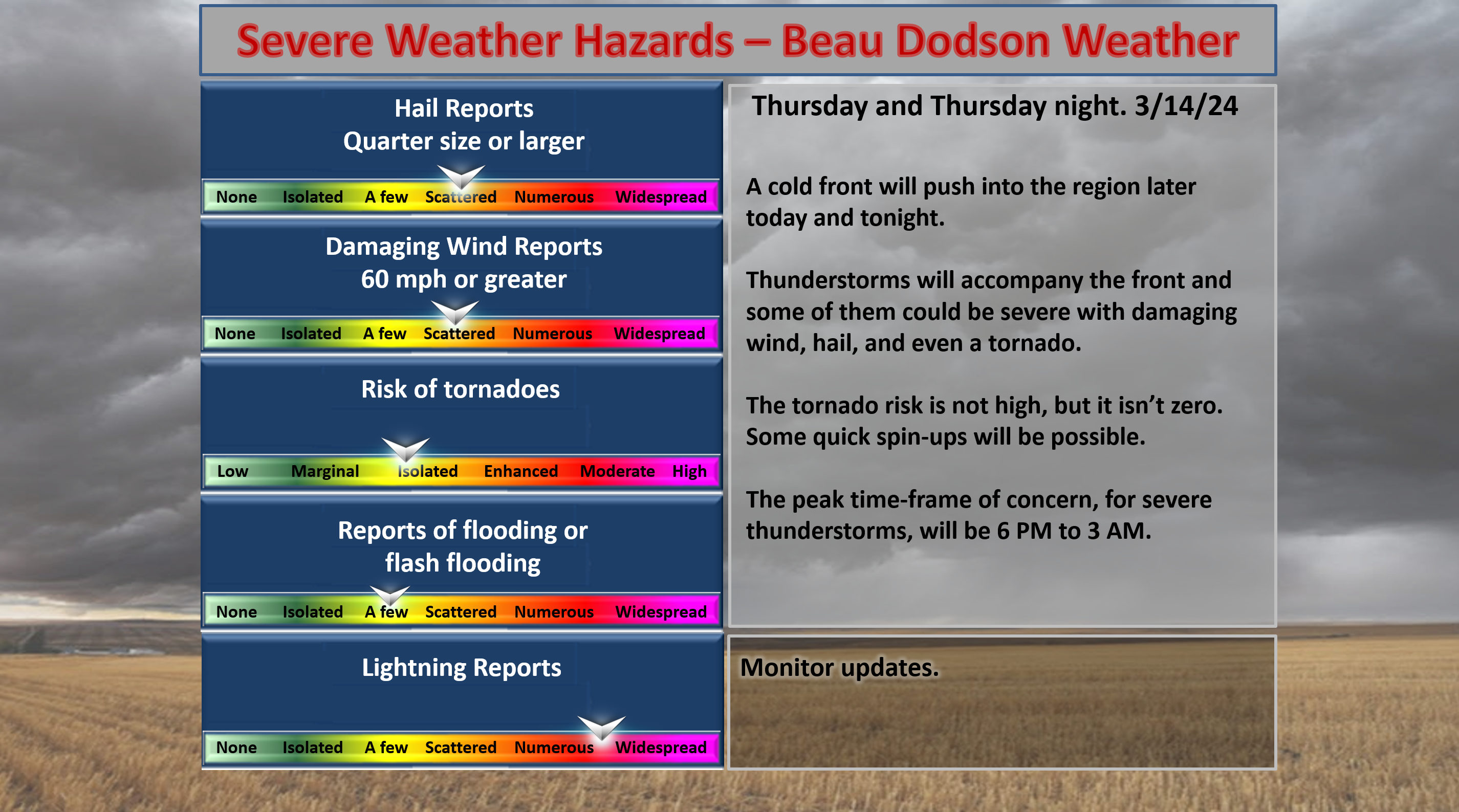
2. Are severe thunderstorms in the forecast? YES. Severe thunderstorms with large hail, damaging wind, and tornadoes will be possible today and tonight. Isolated tornado risk. A greater risk for large hail and damaging wind.
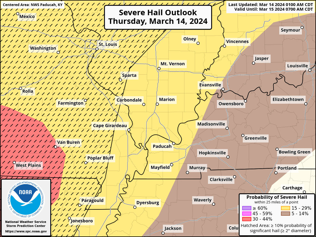
There is a risk of golf ball size hail later this afternoon and evening over mainly southeast Missouri, but we will need to monitor the rest of the area, as well.
3. Is flash flooding in the forecast? POSSIBLE. If thunderstorms train over the same areas, then some flooding will be possible. The risk is a bit higher across southern Missouri into northwest Tennessee.
4. Will non-thunderstorm winds top 40 mph? NO.
5. Will the heat index exceed 100 degrees? NO.
6. Will the wind chill dip below 10 degrees? NO.
7. Is measurable snow and/or sleet in the forecast? NO.
8. Is freezing rain/ice in the forecast? NO.
Freezing rain is rain that falls and instantly freezes on objects such as trees and power lines Freezing fog possible, as well.
.

Fire weather risk level.
Thursday through Thursday night: 4. Low risk.
Friday: 3. Very low risk.
Friday night: 3. Very low risk.
Fire Weather Discussion
It will be warm and breezy today with showers and thunderstorms increasing in coverage through the day and into tonight as a cold front passes through the region. Widespread wetting rains are expected, with the highest totals of 1-1.5 inches forecast along the AR and TN borders. Drier and cooler weather will return this weekend.
A Haines Index of 6 means a high potential for an existing fire to become large or exhibit erratic fire behavior, 5 means medium potential, 4 means low potential, and anything less than 4 means very low potential.
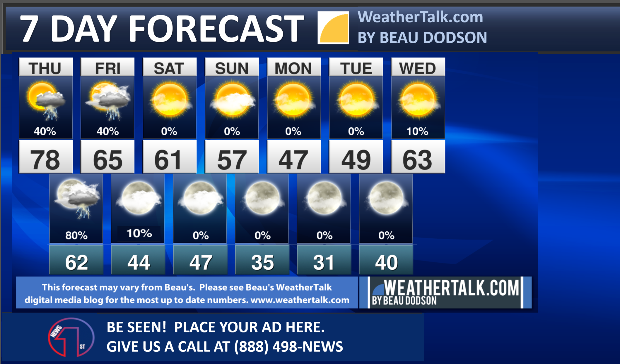
Seven-day forecast for southeast Missouri, southern Illinois, western Kentucky, and western Tennessee.
This is a BLEND for the region. Scroll down to see the region by region forecast.
.

THE FORECAST IS GOING TO VARY FROM LOCATION TO LOCATION.
Scroll down to see your local forecast details.
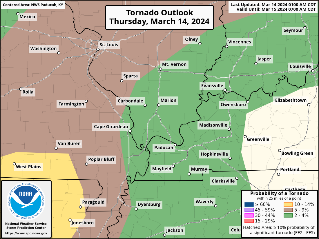
Here is the latest Storm Prediction Center tornado outlook.
The yellow zone has the highest risk. Brown is the second highest risk. Green is the lowest risk.
Remember, what I always say, the weather doesn’t always follow our color charts. A tornado in the yellow or a tornado in green is still a tornado.
Here is the latest Storm Prediction Center hail risk outlook. The hatched area is where very large hail is possible.
Some NWS graphics (Paducah office)
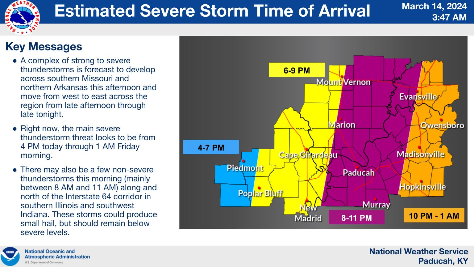
Some showers and storms are possible BEFORE the main time-frame of concern.
This graphic shows you the time-frame of main concern (which is evening and into the overnight hours).

Radars and Lightning Data
Interactive-city-view radars. Clickable watches and warnings.
https://wtalk.co/B3XHASFZ
If the radar is not updating then try another one. If a radar does not appear to be refreshing then hit Ctrl F5. You may also try restarting your browser.
Backup radar site in case the above one is not working.
https://weathertalk.com/morani
Regional Radar
https://imagery.weathertalk.com/prx/RadarLoop.mp4
** NEW ** Zoom radar with chaser tracking abilities!
ZoomRadar
Lightning Data (zoom in and out of your local area)
https://wtalk.co/WJ3SN5UZ
Not working? Email me at beaudodson@usawx.com
.
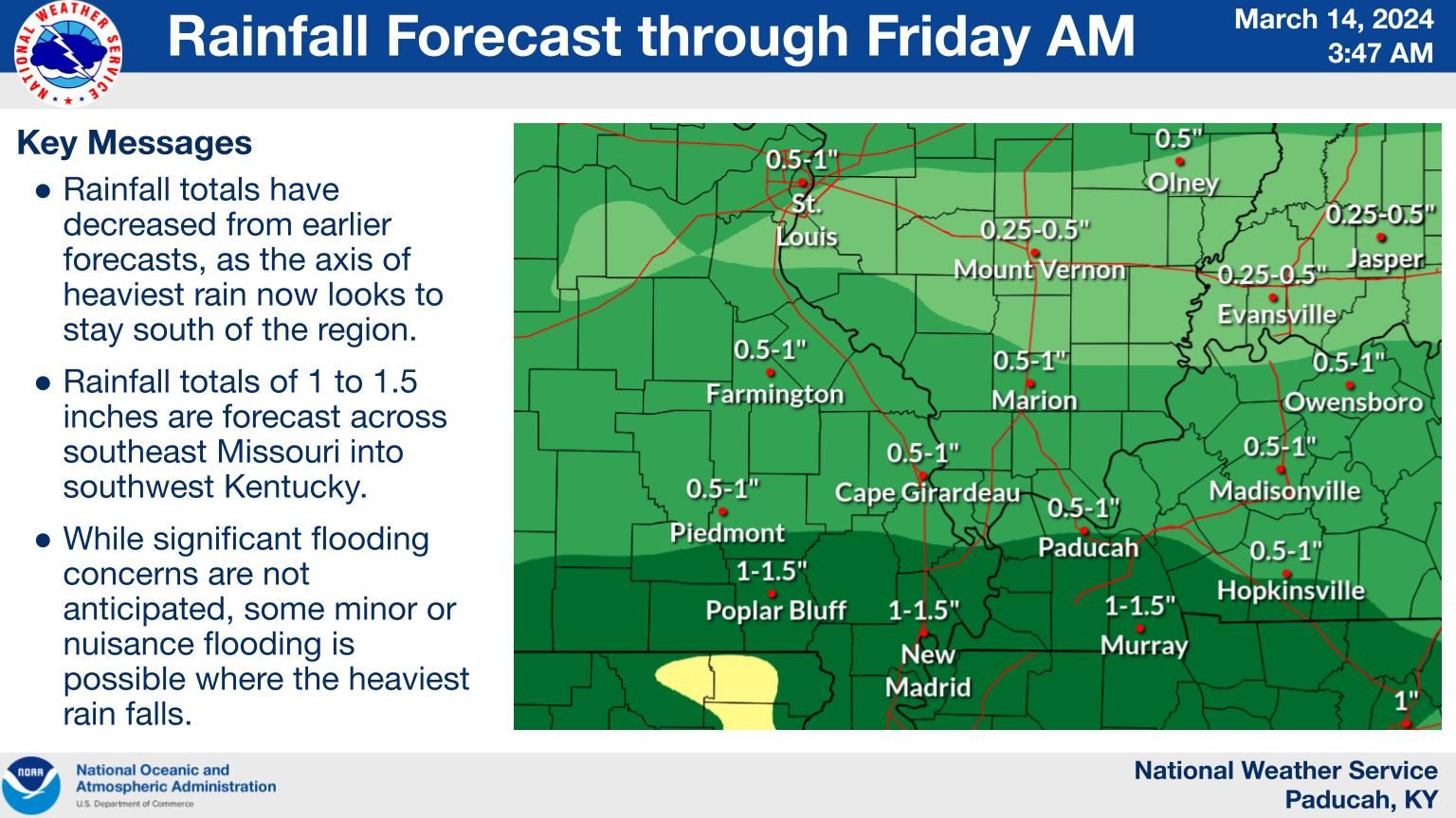
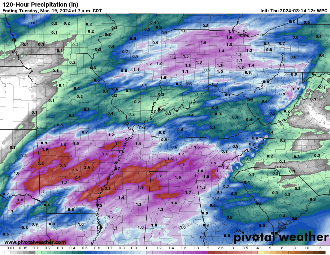
Rain totals today into Friday.
As always, totals will vary, but this is the general idea. Hopefully, most locations will receive some rain. We are in drought and there have been quite a few field and grass fires.
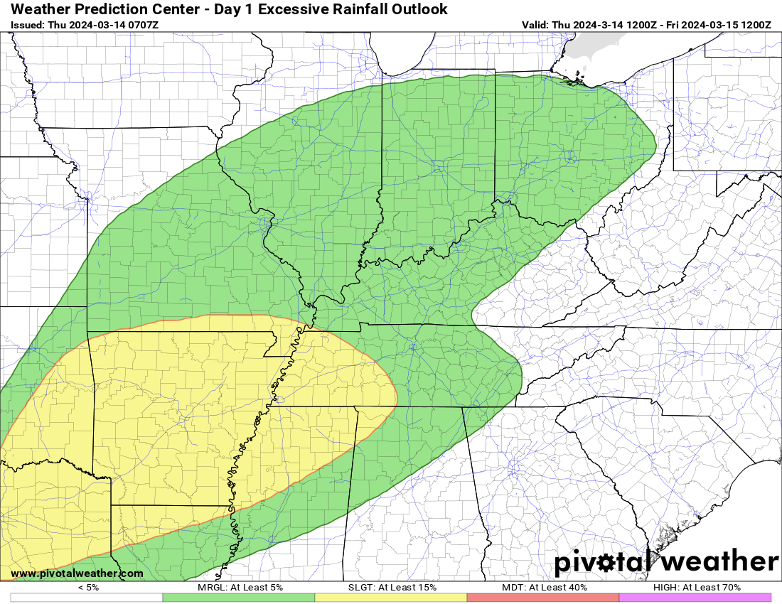
Flash Flood Outlook
The WPC/NOAA has outlined a level one and two risk of flash flooding. This will be for tonight.
.
48-hour forecast Graphics


.
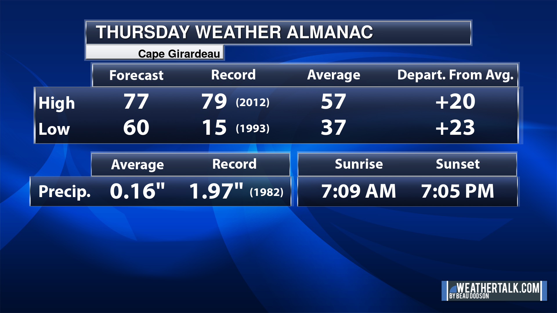
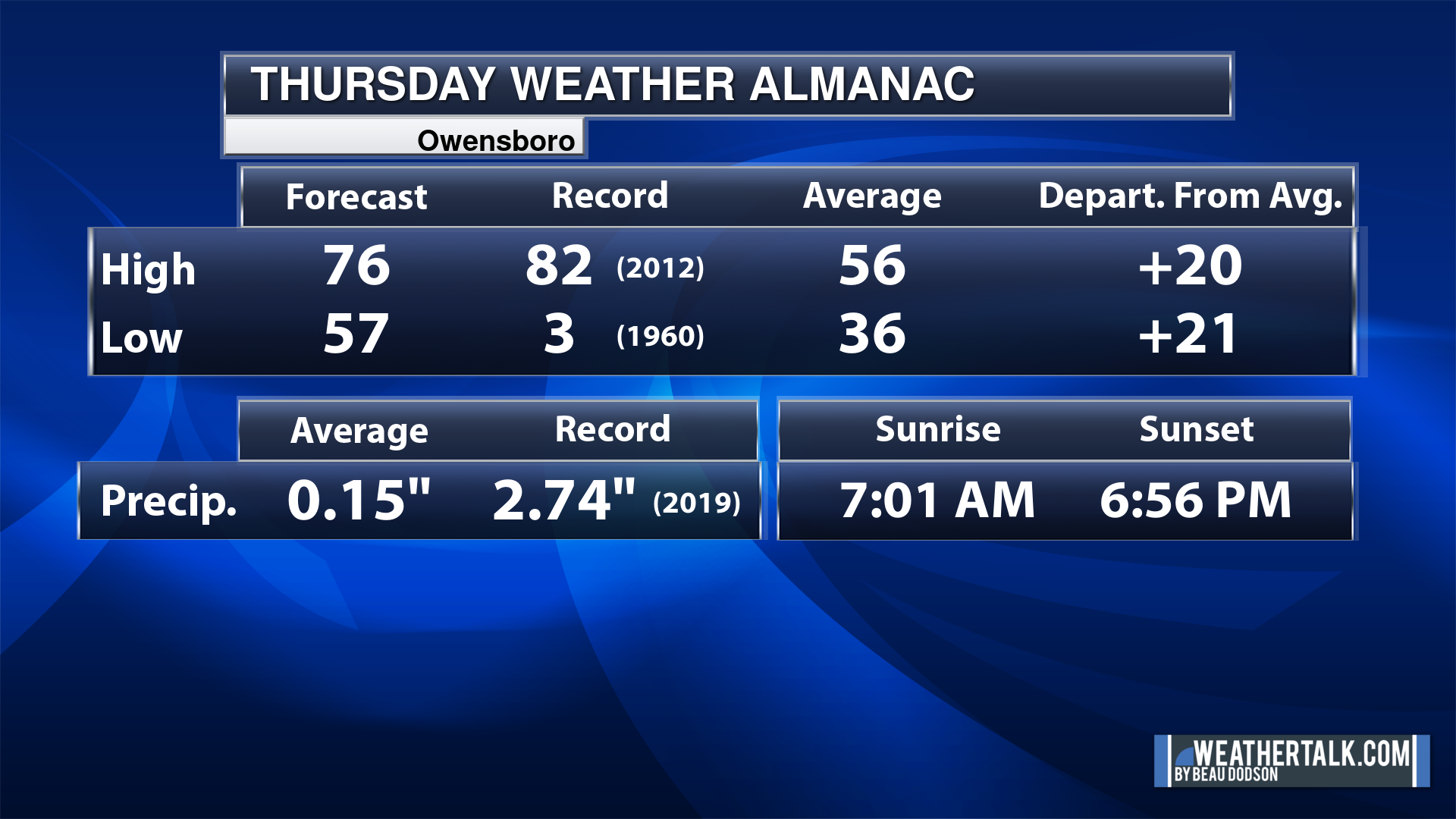
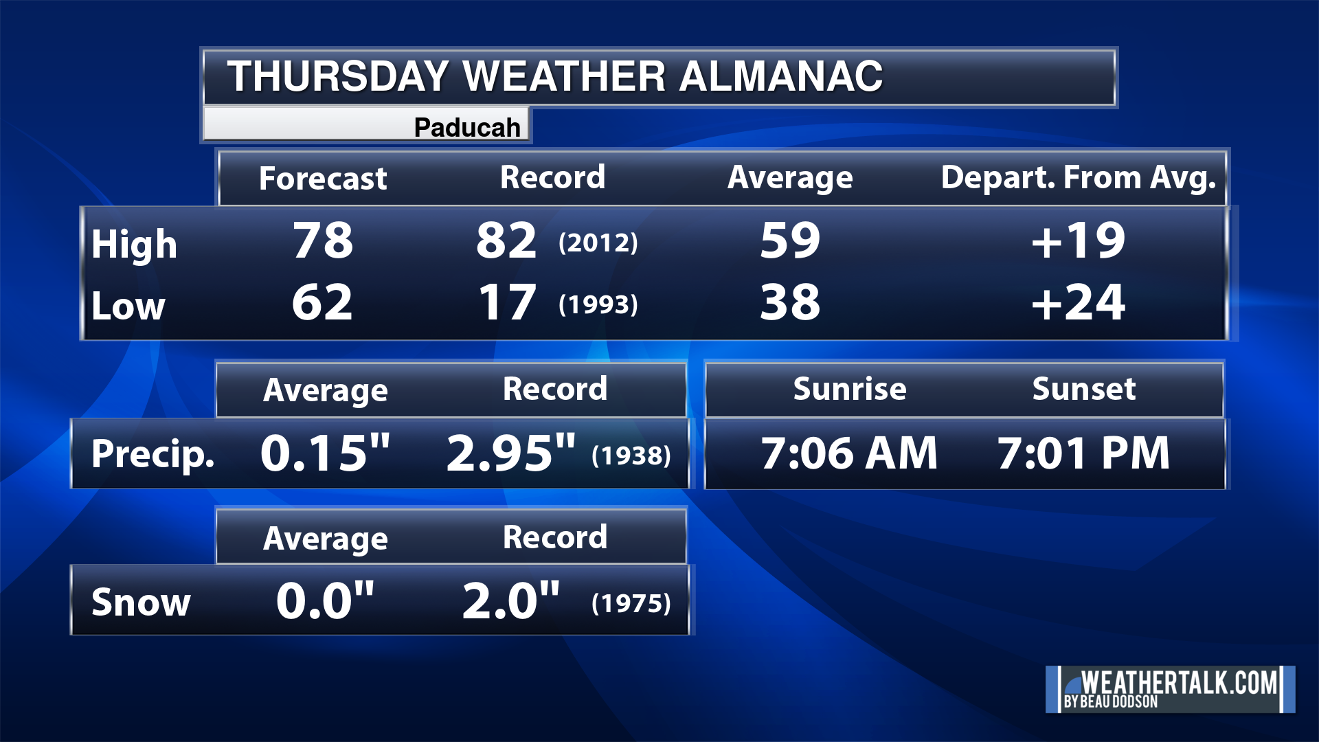
Today’s Local Almanacs (for a few select cities). Your location will be comparable.
Note, the low is this morning’s low and not tomorrows.
The forecast temperature shows you today’s expected high and this morning’s low.
The graphic shows you the record high and record low for today. It shows you what year that occurred, as well.
It then shows you what today’s average temperature is.
It shows you the departures (how may degrees above or below average temperatures will be ).
It shows you the average precipitation for today. Average comes from thirty years of rain totals.
It also shows you the record rainfall for the date and what year that occurred.
The sunrise and sunset are also shown.


![]()
.
.
Thursday Forecast: A mix of sun and clouds. A chance of showers and thunderstorms. Chances will be higher west northwest vs south southeast.
What is the chance of precipitation?
Far northern southeast Missouri ~ 70%
Southeast Missouri ~ 60%
The Missouri Bootheel ~ 40%
I-64 Corridor of southern Illinois ~ 40%
Southern Illinois ~ 40%
Extreme southern Illinois (southern seven counties) ~ 40%
Far western Kentucky (Purchase area) ~ 30%
The Pennyrile area of western KY ~ 20%
Northwest Kentucky (near Indiana border) ~ 20%
Northwest Tennessee ~ 20%
Coverage of precipitation: Numerous northwest. Isolated southeast.
Timing of the precipitation: Any given point of time.
Far northern southeast Missouri ~ 75° to 80°
Southeast Missouri ~ 75° to 80°
The Missouri Bootheel ~ 75° to 80°
I-64 Corridor of southern Illinois ~ 75° to 80°
Southern Illinois ~ 75° to 80°
Extreme southern Illinois (southern seven counties) ~ 75° to 80°
Far western Kentucky ~ 75° to 80°
The Pennyrile area of western KY ~ 75° to 80°
Northwest Kentucky (near Indiana border) ~ 75° to 80°
Northwest Tennessee ~ 75° to 80°
Winds will be from this direction: South southwest 10 to 25 mph. Gusty.
Wind chill or heat index (feels like) temperature forecast: 70° to 78°
What impacts are anticipated from the weather? Wet roadways. Lightning. Monitor the risk of severe weather.
Should I cancel my outdoor plans? No, but monitor updates and the Beau Dodson Weather Radars.
UV Index: 4. Moderate.
Sunrise: 7:07 AM
Sunset: 7:02 PM
.
Thursday Night Forecast: Cloudy. Showers and thunderstorms. Some storms could be intense with hail and gusty winds.
What is the chance of precipitation?
Far northern southeast Missouri ~ 90%
Southeast Missouri ~ 90%
The Missouri Bootheel ~ 90%
I-64 Corridor of southern Illinois ~ 90%
Southern Illinois ~ 90%
Extreme southern Illinois (southern seven counties) ~ 90%
Far western Kentucky (Purchase area) ~ 90%
The Pennyrile area of western KY ~ 70%
Northwest Kentucky (near Indiana border) ~ 80%
Northwest Tennessee ~ 90%
Coverage of precipitation: Numerous
Timing of the precipitation: Any given point of time. Less likely after 4 AM vs before.
Temperature range:
Far northern southeast Missouri ~ 52° to 55°
Southeast Missouri ~ 52° to 55°
The Missouri Bootheel ~ 54° to 58°
I-64 Corridor of southern Illinois ~ 52° to 55°
Southern Illinois ~ 52° to 55°
Extreme southern Illinois (southern seven counties) ~ 52° to 55°
Far western Kentucky ~ 56° to 58°
The Pennyrile area of western KY ~ 58° to 62°
Northwest Kentucky (near Indiana border) ~ 54° to 56°
Northwest Tennessee ~ 58° to 60°
Winds will be from this direction: Southwest becoming west northwest at 10 to 25 mph. Gusty.
Wind chill or heat index (feels like) temperature forecast: 50° to 56°
What impacts are anticipated from the weather? Wet roadways. Lightning. Monitor the risk of severe thunderstorms.
Should I cancel my outdoor plans? Have a plan B and monitor updates.
Moonrise: 9:33 AM
Moonset:
The phase of the moon: Waxing Crescent
.
Friday Forecast: Morning clouds. A chance of showers and thunderstorms. Mainly early in the day, although showers and storms may linger into the afternoon over our eastern counties.
What is the chance of precipitation?
Far northern southeast Missouri ~ 10%
Southeast Missouri ~ 10%
The Missouri Bootheel ~ 40%
I-64 Corridor of southern Illinois ~ 10%
Southern Illinois ~ 30%
Extreme southern Illinois (southern seven counties) ~ 40%
Far western Kentucky (Purchase area) ~ 40%
The Pennyrile area of western KY ~ 60%
Northwest Kentucky (near Indiana border) ~ 40%
Northwest Tennessee ~ 60%
Coverage of precipitation: Scattered
Timing of the precipitation: Mainly during the morning, but precip may linger over our eastern counties.
Far northern southeast Missouri ~ 62° to 65°
Southeast Missouri ~ 62° to 65°
The Missouri Bootheel ~ 63° to 66°
I-64 Corridor of southern Illinois ~ 62° to 64°
Southern Illinois ~ 62° to 65°
Extreme southern Illinois (southern seven counties) ~ 63° to 66°
Far western Kentucky ~ 63° to 66°
The Pennyrile area of western KY ~ 66° to 68°
Northwest Kentucky (near Indiana border) ~ 63° to 66°
Northwest Tennessee ~ 63° to 66°
Winds will be from this direction: Southwest becoming west northwest at 10 to 20 mph.
Wind chill or heat index (feels like) temperature forecast: 60° to 65°
What impacts are anticipated from the weather? Wet roadways. Lightning.
Should I cancel my outdoor plans? No, but monitor updates and the Beau Dodson Weather Radars.
UV Index: 4. Moderate.
Sunrise: 7:05 AM
Sunset: 7:03 PM
.
Friday Night Forecast: Partly cloudy.
What is the chance of precipitation?
Far northern southeast Missouri ~ 0%
Southeast Missouri ~ 0%
The Missouri Bootheel ~ 0%
I-64 Corridor of southern Illinois ~ 0%
Southern Illinois ~ 0%
Extreme southern Illinois (southern seven counties) ~ 0%
Far western Kentucky (Purchase area) ~ 0%
The Pennyrile area of western KY ~ 0%
Northwest Kentucky (near Indiana border) ~ 0%
Northwest Tennessee ~ 0%
Coverage of precipitation:
Timing of the precipitation:
Temperature range:
Far northern southeast Missouri ~ 35° to 40°
Southeast Missouri ~ 36° to 40°
The Missouri Bootheel ~ 42° to 45°
I-64 Corridor of southern Illinois ~ 38° to 40°
Southern Illinois ~ 38° to 42°
Extreme southern Illinois (southern seven counties) ~ 38° to 42°
Far western Kentucky ~ 38° to 42°
The Pennyrile area of western KY ~ 40° to 44°
Northwest Kentucky (near Indiana border) ~ 38° to 42°
Northwest Tennessee ~ 42° to 44°
Winds will be from this direction: North northwest 7 to 14 mph
Wind chill or heat index (feels like) temperature forecast: 34° to 40°
What impacts are anticipated from the weather?
Should I cancel my outdoor plans? No
Moonrise: 10:13 AM
Moonset: 12:36 AM
The phase of the moon: Waxing Crescent
.
Saturday Forecast: Mostly sunny.
What is the chance of precipitation?
Far northern southeast Missouri ~ 0%
Southeast Missouri ~ 0%
The Missouri Bootheel ~ 0%
I-64 Corridor of southern Illinois ~ 0%
Southern Illinois ~ 0%
Extreme southern Illinois (southern seven counties) ~ 0%
Far western Kentucky (Purchase area) ~ 0%
The Pennyrile area of western KY ~ 0%
Northwest Kentucky (near Indiana border) ~ 0%
Northwest Tennessee ~ 0%
Coverage of precipitation:
Timing of the precipitation:
Far northern southeast Missouri ~ 63° to 66°
Southeast Missouri ~ 63° to 66°
The Missouri Bootheel ~ 63° to 66°
I-64 Corridor of southern Illinois ~ 63° to 66°
Southern Illinois ~ 63° to 66°
Extreme southern Illinois (southern seven counties) ~ 63° to 66°
Far western Kentucky ~ 63° to 66°
The Pennyrile area of western KY ~ 63° to 66°
Northwest Kentucky (near Indiana border) ~ 63° to 66°
Northwest Tennessee ~ 63° to 66°
Winds will be from this direction: West northwest becoming west 7 to 14 mph
Wind chill or heat index (feels like) temperature forecast: 60° to 65°
What impacts are anticipated from the weather?
Should I cancel my outdoor plans? No
UV Index: 6. High.
Sunrise: 7:04 AM
Sunset: 7:04 PM
.
Saturday Night Forecast: Becoming partly cloudy.
What is the chance of precipitation?
Far northern southeast Missouri ~ 0%
Southeast Missouri ~ 0%
The Missouri Bootheel ~ 0%
I-64 Corridor of southern Illinois ~ 0%
Southern Illinois ~ 0%
Extreme southern Illinois (southern seven counties) ~ 0%
Far western Kentucky (Purchase area) ~ 0%
The Pennyrile area of western KY ~ 0%
Northwest Kentucky (near Indiana border) ~ 0%
Northwest Tennessee ~ 0%
Coverage of precipitation:
Timing of the precipitation:
Temperature range:
Far northern southeast Missouri ~ 40° to 45°
Southeast Missouri ~ 42° to 44°
The Missouri Bootheel ~ 43° to 46°
I-64 Corridor of southern Illinois ~ 40° to 45°
Southern Illinois ~ 42° to 45°
Extreme southern Illinois (southern seven counties) ~ 44° to 46°
Far western Kentucky ~ 44° to 46°
The Pennyrile area of western KY ~ 44° to 46°
Northwest Kentucky (near Indiana border) ~ 42° to 45°
Northwest Tennessee ~ 44° to 46°
Winds will be from this direction: Southwest becoming west 7 to 14 mph
Wind chill or heat index (feels like) temperature forecast: 40° to 45°
What impacts are anticipated from the weather?
Should I cancel my outdoor plans? No
Moonrise: 11:00 AM
Moonset: 1:43 AM
The phase of the moon: First Quarter
.
Click here if you would like to return to the top of the page.

-
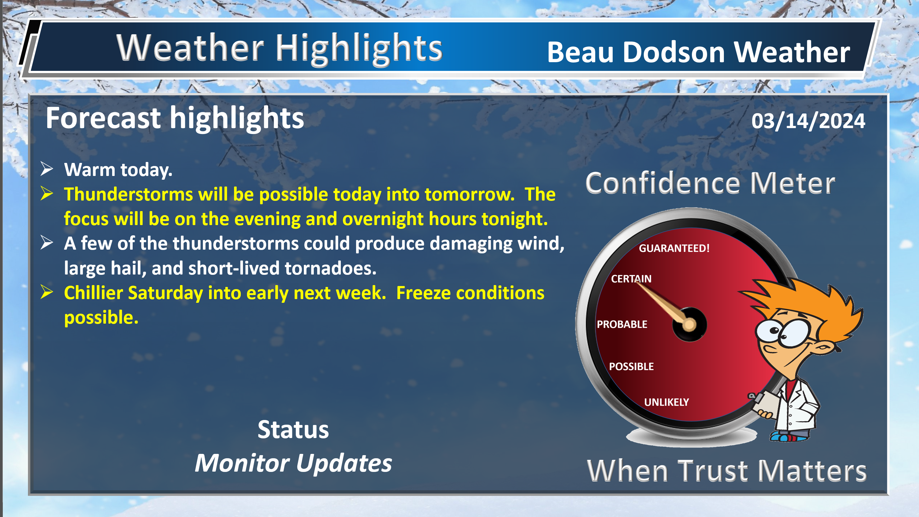
- Warm today. Breezy, at times.
- Showers and thunderstorms today and especially tonight.
- Some of the storms could be severe with damaging wind, hail, and tornadoes. Monitor your Beau Dodson Weather App.
Weather advice:
Do you have any suggestions or comments? Email me at beaudodson@usawx.com
Make sure you have three to five ways of receiving your severe weather information.
.
Beau’s Forecast Discussion
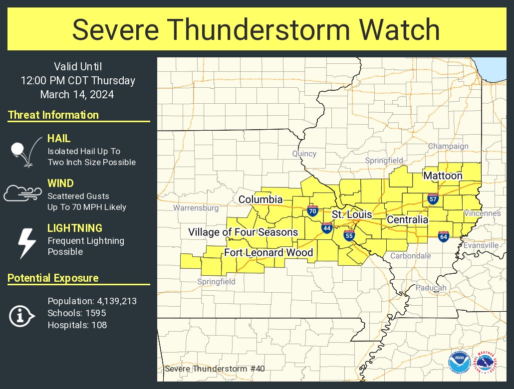
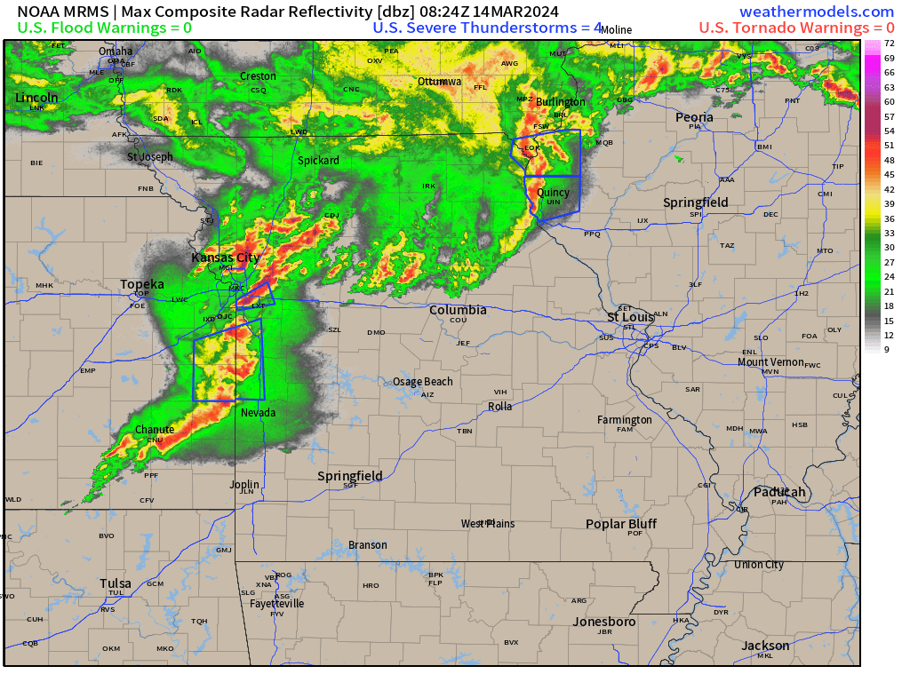
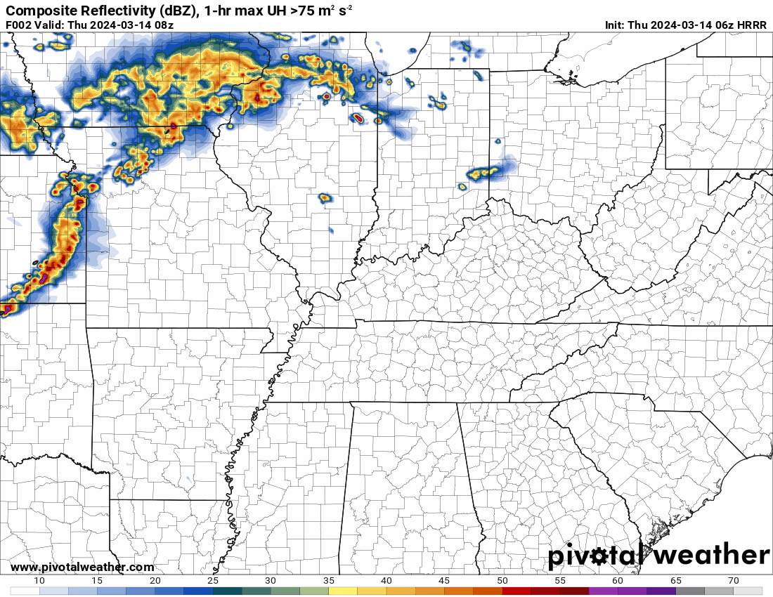
First, a severe thunderstorm watch has been issued for our far northwest counties. This is for a line of thunderstorms moving through western Missouri. That line is moving eastward. It could clip our northern counties, but with time I suspect it will weaken.
4:45 AM radar
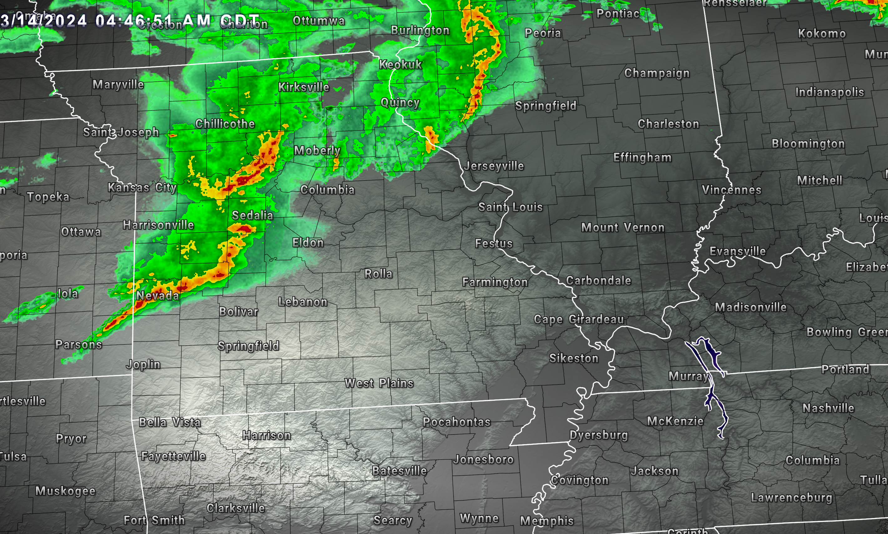
Radar loop from 4:45 AM
See the radars at the top or bottom of the page for the most up to date radars.
The Paducah, KY and St Louis, MO NWS radars were down for repairs this morning. Hopefully, they will get those working again.
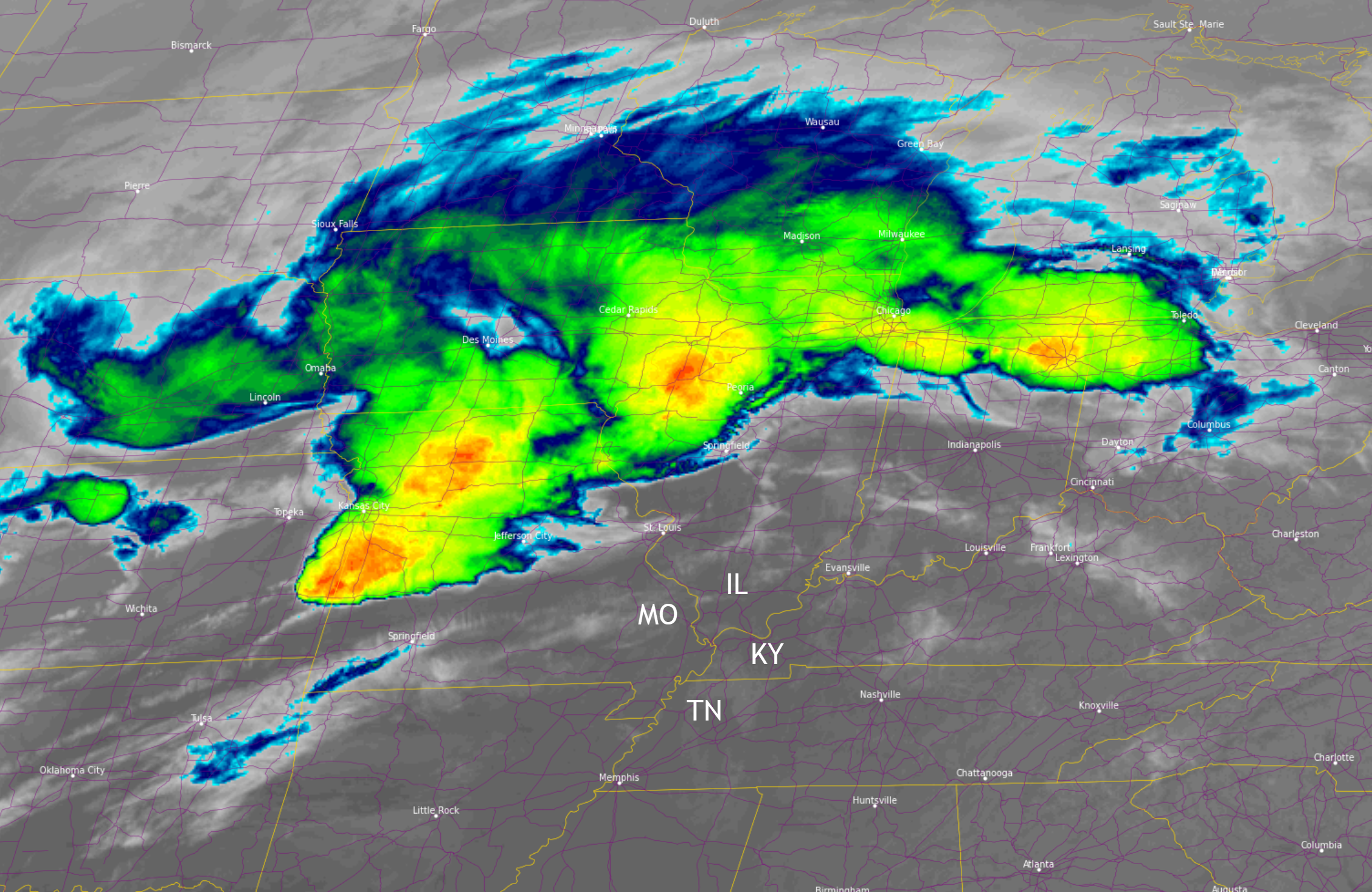
This is what satellite looked like early this morning. Those bright cloud covers are thunderstorm tops. Very cold cloud tops.
That line will push into eastern Missouri later this morning, weakening.
There will likely be a bit of a thunderstorm lull later this morning and early afternoon. Then, with time, more thunderstorms will form.
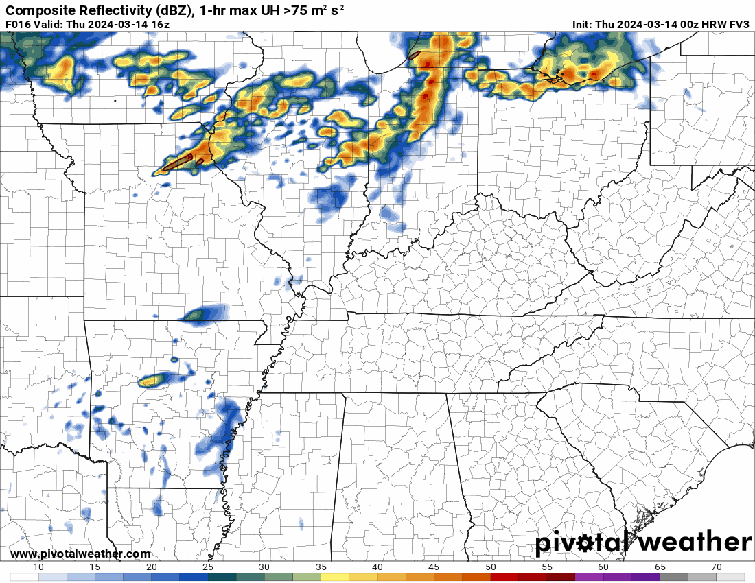
Supercells are likely to form over Arkansas, Missouri, and Illinois this afternoon and evening. Some of these thunderstorms could produce 70 mph wind, golf ball size hail, and tornadoes.
With time those supercells will become a line of thunderstorms and will push across our region. It does appear the activity will be numerous/widespread.
The Storm Prediction Center has a risk for severe weather in our region, mainly this evening into the overnight hours. We are watching 4 PM to 3 AM time-frame.
There remain questions, as there usually are, about where storms form and in what shape they will be when they arrive in your county.
The best advice is to monitor updates.
Locally heavy rain of one to three inches will occur where thunderstorms train repeatedly over the same locations.
Generally, however, rain totals of 0.50″ to 1.00″ are expected. Then, pockets of higher totals are likely. The highest totals are forecast to be across northern Arkansas along the extreme southern portion of Missouri into the Bootheel and then into northwest Tennessee.
Make sure your Beau Dodson Weather app is up and working. Open it, if you ever are wondering if you missed a message. Don’t forget, it has a button that says SEE ALL. You can see all the messages that I have sent out.
Showers and thunderstorms may linger into Friday morning across at least portions of Kentucky and Tennessee.
Shower and thunderstorm chances will be coming to an end across southeast Missouri and southern Illinois during the morning hours.
By Friday night, the region should be dry. Cooler, but nothing extreme.
Highs Saturday will rise into the sixties. Colder Saturday night into early next week. Lows will drop into the 20s and 30s Sunday and Monday night.
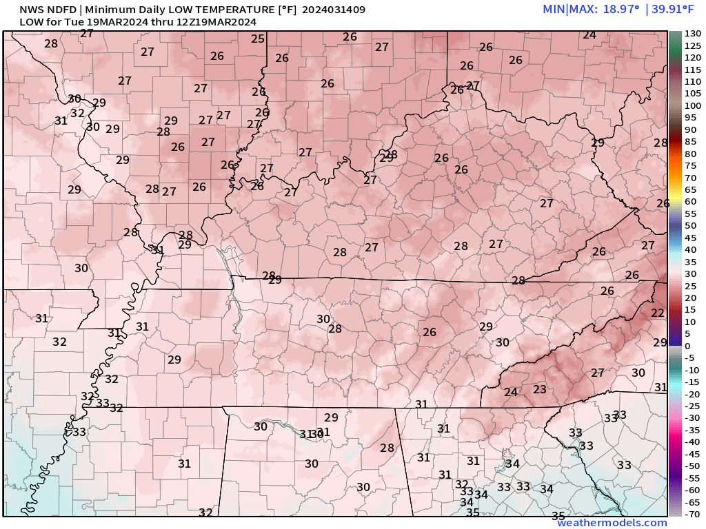
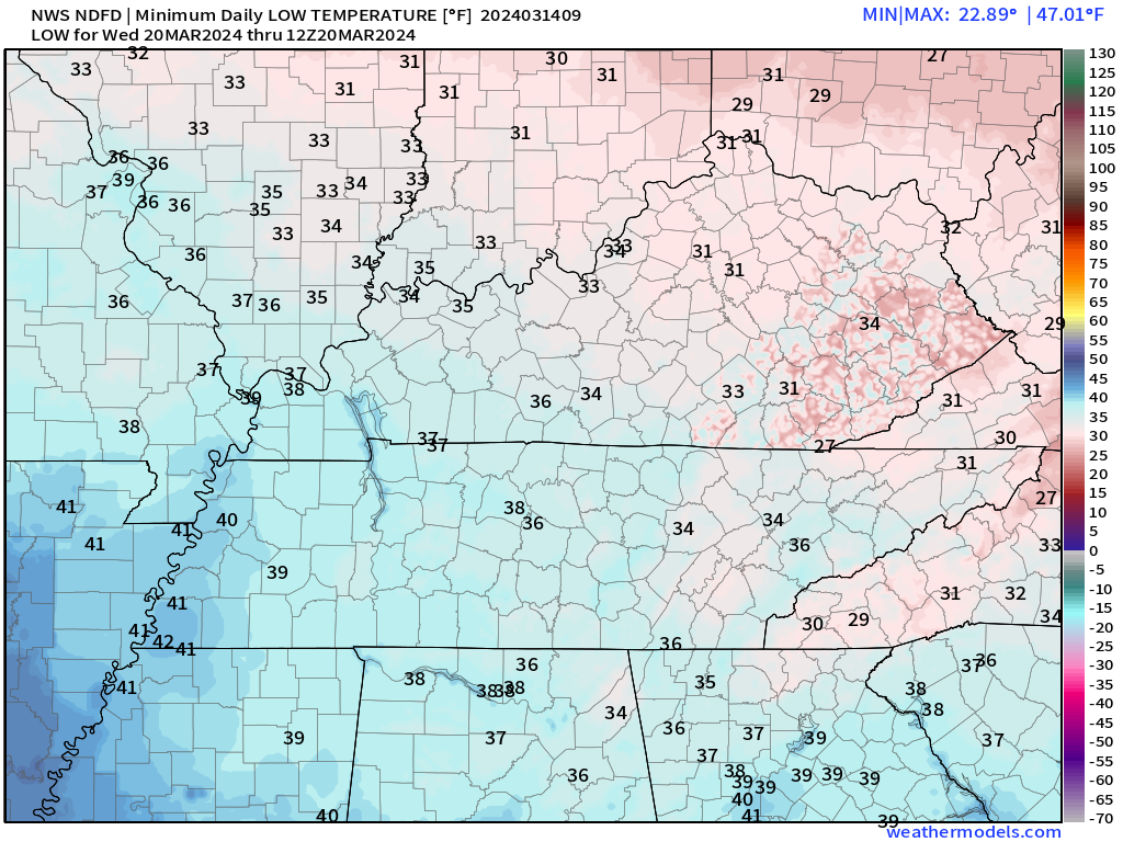
Let’s check out the expected lows. Hopefully, this will moderate with time. Mid twenties would be a hard freeze and would likely cause some damage to plants and fruit trees. Many have bloomed.
Sunday night lows
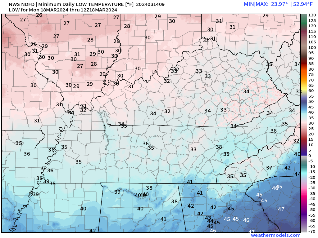
Monday night lows
Tuesday night lows
![]()
.
Click here if you would like to return to the top of the page.
This outlook covers southeast Missouri, southern Illinois, western Kentucky, and far northwest Tennessee.

.
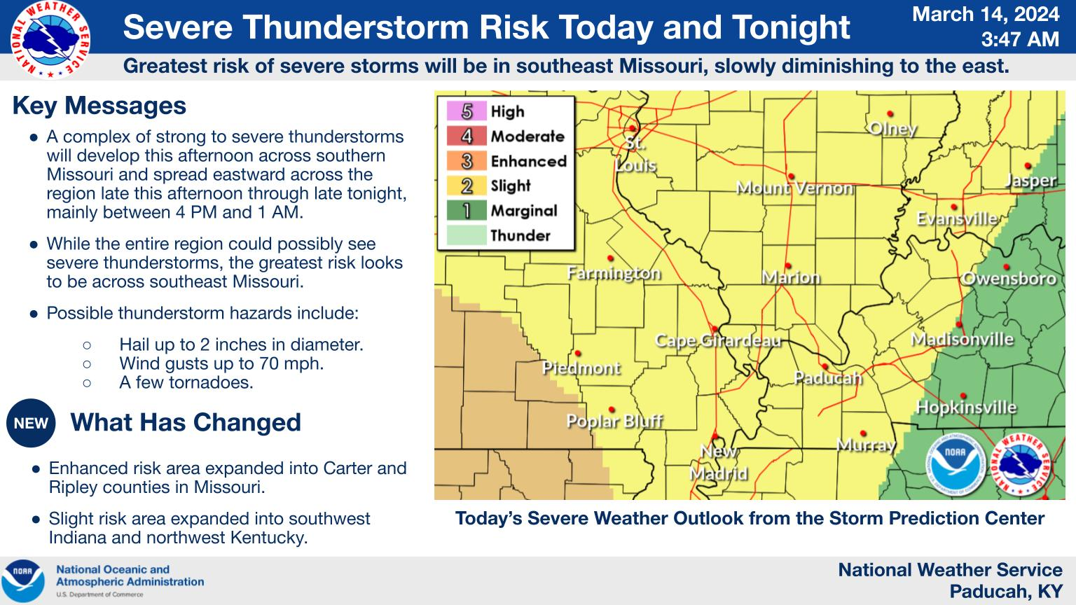
Today’s Storm Prediction Center’s (SPC) Severe Weather Outlook
Light green is where thunderstorms may occur but should be below severe levels.
Dark green is a level one risk. Yellow is a level two risk. Orange is a level three (enhanced) risk. Red is a level four (moderate) risk. Pink is a level five (high) risk.
One is the lowest risk. Five is the highest risk.
A severe storm is one that produces 58 mph wind or higher, quarter or larger size hail, and/or a tornado.
Explanation of tables. Click here.
Day One Severe Weather Outlook

Day One Severe Weather Outlook. Zoomed in on our region.

.
Day One Tornado Probability Outlook

Day One Regional Tornado Outlook. Zoomed in on our region.

.
Day One Large Hail Probability Outlook

Day One Regional Hail Outlook. Zoomed in on our region.

.
Day One High wind Probability Outlook

Day One Regional Wind Outlook. Zoomed in on our region.

.
Tomorrow’s severe weather outlook. Day two outlook.

Day Two Outlook. Zoomed in on our region.

.
Day Three Severe Weather Outlook

.

.
The images below are from NOAA’s Weather Prediction Center.
24-hour precipitation outlook..
 .
.
.
48-hour precipitation outlook.
. .
.
![]()
_______________________________________
.

Click here if you would like to return to the top of the page.
Again, as a reminder, these are models. They are never 100% accurate. Take the general idea from them.
What should I take from these?
- The general idea and not specifics. Models usually do well with the generalities.
- The time-stamp is located in the upper left corner.
.
What am I looking at?
You are looking at computer model data. Meteorologists use many different models to forecast the weather.
Occasionally, these maps are in Zulu time. 12z=7 AM. 18z=1 PM. 00z=7 PM. 06z=1 AM
Green represents light rain. Dark green represents moderate rain. Yellow and orange represent heavier rain.
.
This animation is the FVS Model.
Occasionally, these maps are in Zulu time. 12z=6 AM. 18z=12 PM. 00z=6 PM. 06z=12 AM
Double click images to enlarge them. Blue is snow. Pink is a wintry mix. Green is rain.
.
This animation is the NAM Model.
Occasionally, these maps are in Zulu time. 12z=6 AM. 18z=12 PM. 00z=6 PM. 06z=12 AM
Double click images to enlarge them.
.
This animation is the HRRR Model.
Green is rain. Yellow and orange are heavier rain. Pink is a wintry mix. Blue is snow. Dark blue is heavier snow.
Occasionally, these maps are in Zulu time. 12z=6 AM. 18z=12 PM. 00z=6 PM. 06z=12 AM
Double click images to enlarge them.
.
This animation is the GFS Model.
Green is rain. Yellow and orange are heavier rain. Pink is a wintry mix. Blue is snow. Dark blue is heavier snow.
Occasionally, these maps are in Zulu time. 12z=6 AM. 18z=12 PM. 00z=6 PM. 06z=12 AM
Double click images to enlarge them.
.
This animation is the EC Model.
Green is rain. Yellow and orange are heavier rain. Pink is a wintry mix. Blue is snow. Dark blue is heavier snow.
Occasionally, these maps are in Zulu time. 12z=6 AM. 18z=12 PM. 00z=6 PM. 06z=12 AM
Double click images to enlarge them.
..![]()

.
Click here if you would like to return to the top of the page.
.Average high temperatures for this time of the year are around 56 degrees.
Average low temperatures for this time of the year are around 36 degrees.
Average precipitation during this time period ranges from 0.60″ to 1.20″
Six to Ten Day Outlook.
Blue is below average. Red is above average. The no color zone represents equal chances.
Average highs for this time of the year are in the lower 60s. Average lows for this time of the year are in the lower 40s.
Check back for this graphic
Green is above average precipitation. Yellow and brown favors below average precipitation. Average precipitation for this time of the year is around one inch per week.
Check back for this graphic
.

Average low temperatures for this time of the year are around 38 degrees.
Average precipitation during this time period ranges from 0.60″ to 1.20″
.
Eight to Fourteen Day Outlook.
Blue is below average. Red is above average. The no color zone represents equal chances.
Check back for this graphic
Green is above average precipitation. Yellow and brown favors below average precipitation. Average precipitation for this time of the year is around one inch per week.
Check back for this graphic
.
![]()
The app is for subscribers. Subscribe at www.weathertalk.com/welcome then go to your app store and search for WeatherTalk
Subscribers, PLEASE USE THE APP. ATT and Verizon are not reliable during severe weather. They are delaying text messages.
The app is under WeatherTalk in the app store.

Apple users click here

Android users click here
.
Radars and Lightning Data
Interactive-city-view radars. Clickable watches and warnings.
https://wtalk.co/B3XHASFZ
If the radar is not updating then try another one. If a radar does not appear to be refreshing then hit Ctrl F5. You may also try restarting your browser.
Backup radar site in case the above one is not working.
https://weathertalk.com/morani
Regional Radar
https://imagery.weathertalk.com/prx/RadarLoop.mp4
** NEW ** Zoom radar with chaser tracking abilities!
ZoomRadar
Lightning Data (zoom in and out of your local area)
https://wtalk.co/WJ3SN5UZ
Not working? Email me at beaudodson@usawx.com
National map of weather watches and warnings. Click here.
Storm Prediction Center. Click here.
Weather Prediction Center. Click here.
.

Live lightning data: Click here.
Real time lightning data (another one) https://map.blitzortung.org/#5.02/37.95/-86.99
Our new Zoom radar with storm chases
.
.

Interactive GOES R satellite. Track clouds. Click here.
GOES 16 slider tool. Click here.
College of DuPage satellites. Click here
.

Here are the latest local river stage forecast numbers Click Here.
Here are the latest lake stage forecast numbers for Kentucky Lake and Lake Barkley Click Here.
.
.
Find Beau on Facebook! Click the banner.


 .
.