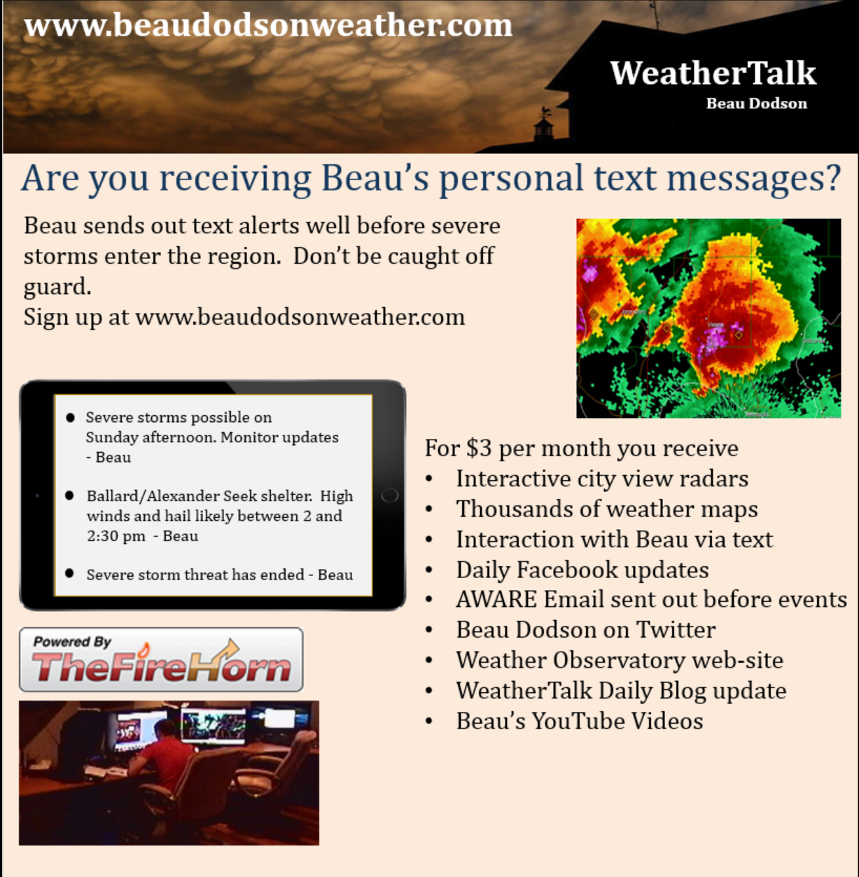
This is what you are missing out on if you are not a $3 a month subscriber!
- Daily forecast texts from my computer to your app/cell phone
- Severe weather app/text alerts from my keyboard to your app/cell phone
- Social media links sent directly to your app/cell phone. When I update the blog, videos, or Facebook you will receive the link.
- Missouri Valley centered video updates
- Ohio Valley centered video updates
- Long-range video updates
- Week one temperature and precipitation outlook
- Week two temperature and precipitation outlook
- Week three and four temperature and precipitation outlook
- Monthly outlooks
Monthly operating costs for Weather Talk can top $2000.00. Your $3 subscription helps pay for those costs. I work for you.
.
.

.

.
Your $3 per month also helps support these local charity projects.
.

.

.
March 1, 2018
Thursday Forecast Details
Forecast: Mostly cloudy early. Highs early in the day. Windy. Turning cooler. A chance of showers and perhaps a few thunderstorms before noon. Showers ending from west to east.
Temperatures: MO ~ 54 to 58 IL ~ 54 to 58 KY ~ 56 to 58
What is the chance of precipitation? MO ~ 30% ending IL ~ 60% ending KY ~ 60% mainly early TN ~ 60% mainly early
Coverage of precipitation: Scattered early. Ending west to east.
Wind chill values: N/A
Accumulating snow or ice: No
Winds: Southwest to west & northwest at 15 to 30 mph with gusts to 44 mph
What impacts are anticipated from the weather? Wet roadways. Strong winds.
My confidence in the forecast verifying: High
Is severe weather expected? No
The NWS defines severe weather as 58 mph wind or great, 1″ hail or larger, and/or tornadoes
Should I cancel my outdoor plans? No, but monitor updates. Some morning showers possible. Strong winds.
.
Thursday Night Forecast Details:
Forecast: Clearing. Cool. Windy.
Temperatures: MO ~ 28 to 34 IL ~ 28 to 34 KY ~ 28 to 34
What is the chance of precipitation? MO ~ 0% IL ~ 0% KY ~ 0% TN ~ 0%
Coverage of precipitation: None
Wind chill values: N/A
Accumulating snow or ice: No
Winds: West and northwest at 10 to 20 mph with gusts to 25
What impacts are anticipated from the weather? None
My confidence in the forecast verifying: High
Is severe weather expected? No
The NWS defines severe weather as 58 mph wind or great, 1″ hail or larger, and/or tornadoes
Should I cancel my outdoor plans? No
.
March 2, 2018
Friday Forecast Details
Forecast: Mostly sunny. Nice.
Temperatures: MO ~ 52 to 56 IL ~ 52 to 56 KY ~ 54 to 58
What is the chance of precipitation? MO ~ 0% IL ~ 0% KY ~ 0% TN ~ 0%
Coverage of precipitation: None
Wind chill values: N/A
Accumulating snow or ice: No
Winds: Northeast and north at 7 to 14 mph
What impacts are anticipated from the weather? None
My confidence in the forecast verifying: High
Is severe weather expected? No
The NWS defines severe weather as 58 mph wind or great, 1″ hail or larger, and/or tornadoes
Should I cancel my outdoor plans? No
.
Friday Night Forecast Details:
Forecast: Mostly clear and chilly.
Temperatures: MO ~ 28 to 34 IL ~ 28 to 34 KY ~ 30 to 34
What is the chance of precipitation? MO ~ 0% IL ~ 0% KY ~ 0% TN ~ 0%
Coverage of precipitation: None
Wind chill values: N/A
Accumulating snow or ice: No
Winds: North at 4 to 8 mph
What impacts are anticipated from the weather? None
My confidence in the forecast verifying: High
Is severe weather expected? No
The NWS defines severe weather as 58 mph wind or great, 1″ hail or larger, and/or tornadoes
Should I cancel my outdoor plans? No
.
March 3, 2018
Saturday Forecast Details
Forecast: Mostly sunny.
Temperatures: MO ~ 53 to 56 IL ~ 53 to 56 KY ~ 53 to 56
What is the chance of precipitation? MO ~ 0% IL ~ 0% KY ~ 0% TN ~ 0%
Coverage of precipitation: None
Wind chill values: N/A
Accumulating snow or ice: No
Winds: East at 4 to 8 mph
What impacts are anticipated from the weather? None
My confidence in the forecast verifying: High
Is severe weather expected? No
The NWS defines severe weather as 58 mph wind or great, 1″ hail or larger, and/or tornadoes
Should I cancel my outdoor plans? No
.
Saturday Night Forecast Details:
Forecast: Mostly clear.
Temperatures: MO ~ 30 to 35 IL ~ 30 to 35 KY ~ 30 to 35
What is the chance of precipitation? MO ~ 0% IL ~ 0% KY ~ 0% TN ~ 0%
Coverage of precipitation: None
Wind chill values: N/A
Accumulating snow or ice: No
Winds: Southeast and east at 4 to 8 mph
What impacts are anticipated from the weather? None
My confidence in the forecast verifying: High
Is severe weather expected? No
The NWS defines severe weather as 58 mph wind or great, 1″ hail or larger, and/or tornadoes
Should I cancel my outdoor plans? No
.
March 4, 2018
Sunday Forecast Details
Forecast: Mostly sunny. Mild. Some increase in clouds late in the day. A 10% of a shower near Poplar Bluff.
Temperatures: MO ~ 56 to 60 IL ~ 56 yo 60 KY ~ 56 to 62
What is the chance of precipitation? MO ~ 10% IL ~ 0% KY ~ 0% TN ~ 0%
Coverage of precipitation: Most likely none
Wind chill values: N/A
Accumulating snow or ice: No
Winds: East and southeast at 5 to 10 mph
What impacts are anticipated from the weather? None
My confidence in the forecast verifying: High
Is severe weather expected? No
The NWS defines severe weather as 58 mph wind or great, 1″ hail or larger, and/or tornadoes
Should I cancel my outdoor plans? No
.
Sunday Night Forecast Details:
Forecast: Increasing clouds. A chance of showers mainly after 2 AM. Rain chances may arrive earlier over southeast Missouri.
Temperatures: MO ~ 40 to 45 IL ~ 40 to 45 KY ~ 40 to 45
What is the chance of precipitation? MO ~ 60% IL ~ 40% KY ~ 40% TN ~ 40%
Coverage of precipitation: Scattered late
Wind chill values: N/A
Accumulating snow or ice: No
Winds: South and southeast at 6 to 12 mph
What impacts are anticipated from the weather? Wet roadways late
My confidence in the forecast verifying: Medium
Is severe weather expected? No
The NWS defines severe weather as 58 mph wind or great, 1″ hail or larger, and/or tornadoes
Should I cancel my outdoor plans? No
.
March 5, 2018
Monday Forecast Details
Forecast: Cloudy. Scattered showers. Breezy.
Temperatures: MO ~ 54 to 58 IL ~ 54 to 58 KY ~ 54 to 58
What is the chance of precipitation? MO ~ 60% IL ~ 60% KY ~ 60% TN ~ 60%
Coverage of precipitation: Scattered
Wind chill values: N/A
Accumulating snow or ice: No
Winds: Southeast and south at 10 to 20 mph and gusty
What impacts are anticipated from the weather? Wet roadways.
My confidence in the forecast verifying: Medium
Is severe weather expected? No
The NWS defines severe weather as 58 mph wind or great, 1″ hail or larger, and/or tornadoes
Should I cancel my outdoor plans? Have a plan B. A few showers possible.
.
Monday Night Forecast Details:
Forecast: Cloudy. A chance of showers early. Rain ending. Cool.
Temperatures: MO ~ 36 to 42 IL ~ 36 to 42 KY ~ 36 to 42
What is the chance of precipitation? MO ~ 40% IL ~ 40% KY ~ 50% TN ~ 50%
Coverage of precipitation: Scattered early
Wind chill values: N/A
Accumulating snow or ice: No
Winds: West at 4 to 8 mph with gusts to 12 mph
What impacts are anticipated from the weather? Wet roadways early
My confidence in the forecast verifying: Medium
Is severe weather expected? No
The NWS defines severe weather as 58 mph wind or great, 1″ hail or larger, and/or tornadoes
Should I cancel my outdoor plans? Monitor
.
March 6, 2018
Tuesday Forecast Details
Forecast: Partly cloudy and breezy.
Temperatures: MO ~ 54 to 58 IL ~ 54 to 58 KY ~ 54 to 58
What is the chance of precipitation? MO ~ 0% IL ~ 0% KY ~ 0% TN ~ 0%
Coverage of precipitation: None
Wind chill values: N/A
Accumulating snow or ice: No
Winds: West at 10 to 20 mph
What impacts are anticipated from the weather? None
My confidence in the forecast verifying: Medium
Is severe weather expected? No
The NWS defines severe weather as 58 mph wind or great, 1″ hail or larger, and/or tornadoes
Should I cancel my outdoor plans? No
.
Tuesday Night Forecast Details:
Forecast: Mostly clear and cool.
Temperatures: MO ~ 33 to 36 IL ~ 33 to 36 KY ~ 33 to 36
What is the chance of precipitation? MO ~ 0% IL ~ 0% KY ~ 0% TN ~ 0%
Coverage of precipitation: None
Wind chill values: N/A
Accumulating snow or ice: No
Winds: West at 6 to 12 mph with gusts to 16 mph
What impacts are anticipated from the weather? None
My confidence in the forecast verifying: Medium
Is severe weather expected? No
The NWS defines severe weather as 58 mph wind or great, 1″ hail or larger, and/or tornadoes
Should I cancel my outdoor plans? No
.

.
Today through Tuesday: Winter weather is not anticipated.
.

.
The National Weather Service definition of a severe thunderstorm is one that produces quarter size hail or larger, 58 mph winds or greater, and/or a tornado.
Today through Monday: No severe weather. Lightning is possible today and again on Monday.
.

.
Need to check the latest river crest forecast? Click here.
Please check out the interactive city view radars to track the precipitation.
HIGHLIGHTS
- Rain ending west to east today.
- Dry tonight through Sunday afternoon.
- Strong and gusty winds today. Gusts above 40 mph possible.
- Flooding will continue to be an issue in many areas. Avoid flooded roadways.
- Dry Thursday night through Sunday afternoon.
- Rain chances may return Sunday night into Monday.
High confidence today into Sunday afternoon.
Need to check the river crest forecast? Click here.
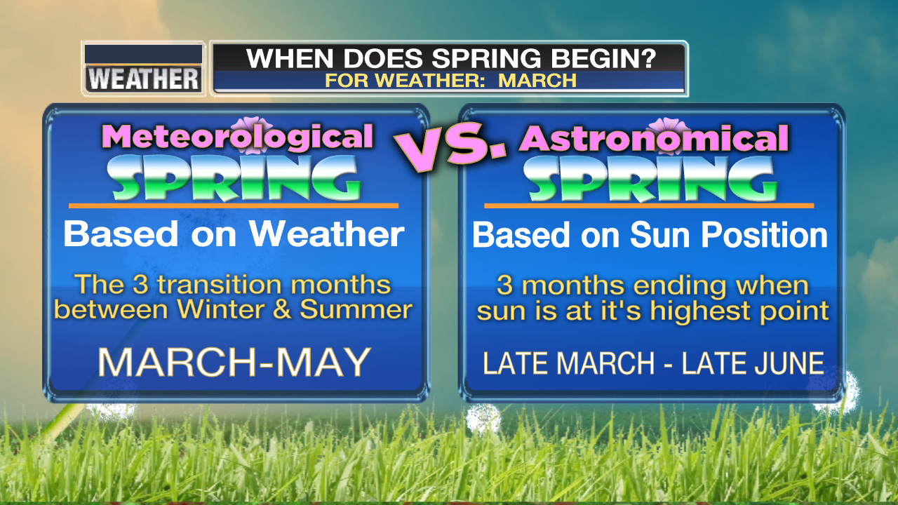
Welcome to meteorological spring! I found this graphic online and it sums it up nicely.
Welcome to meteorological spring, everyone. We made it!
I found this graphic online and it sums it up nicely.
Can it still snow? Sure, it could, but odds decrease with each passing day.
Our average low and high temperature will slowly climb as we move into the middle and end of March.
What are today’s average high and low temperatures?
33 degrees and 55 degrees.
What about March 31st?
43 degrees and 65 degrees!
.
.
More rain fell across the region overnight. The heaviest rains, however, we centered across Arkansas into Tennessee. That means more water coming down the Tennessee River basin into the LBL area and eventually into some of our rivers.
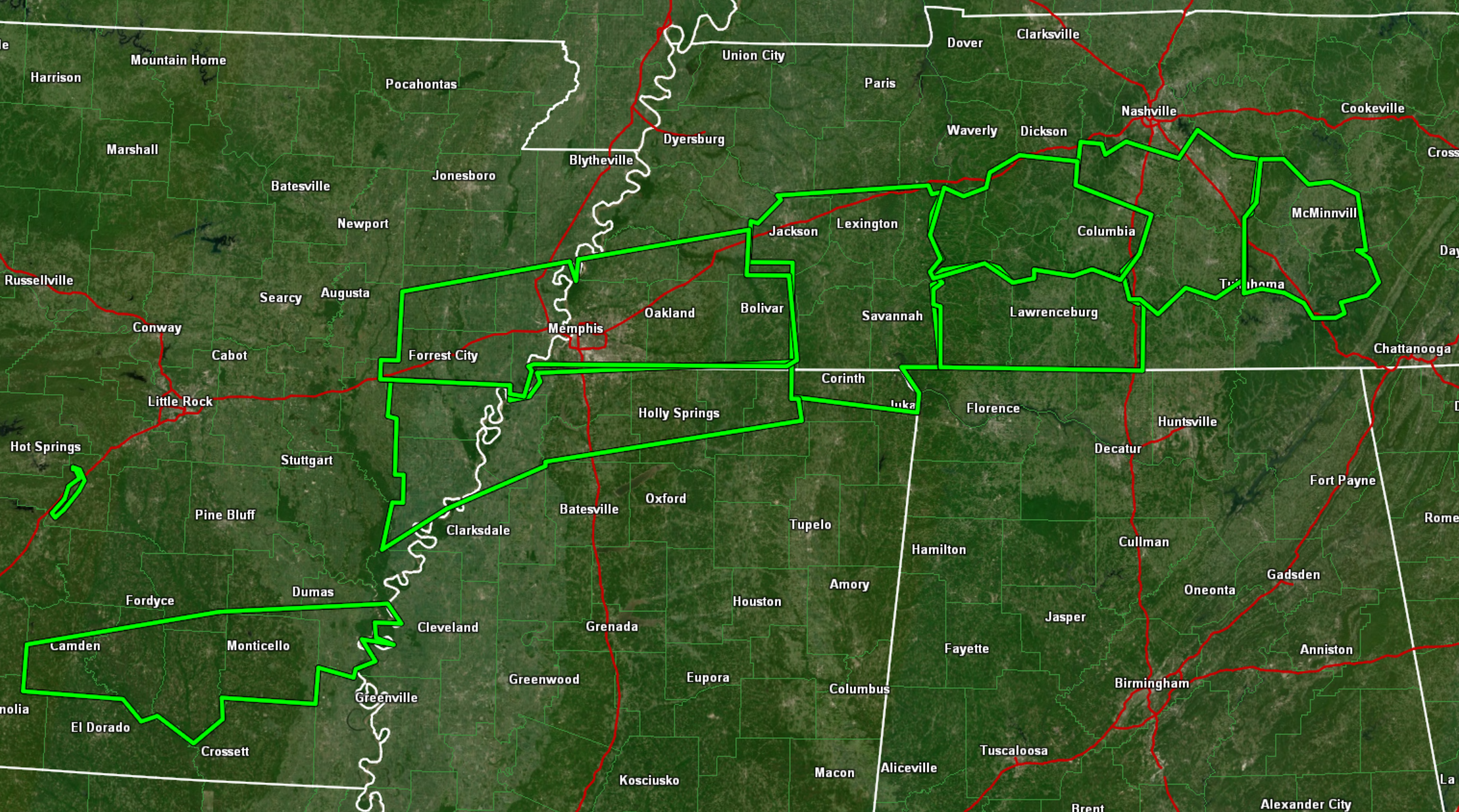
Here are the flash flood warnings that are in effect (as of 8 AM Thursday). A train of them.
.
.
Rainfall totals from the past 24 hours. Very heavy rain to our south.
Click image to enlarge
.

.
Please avoid flooded roadways. Many roads in the region are flooded.
Showers and thunderstorms this morning will end from west to east. We will have lingering clouds into this afternoon.
Dry weather will last into Sunday afternoon before another weather maker delivers more rain to the region Sunday night and Monday. At this time, the rain totals don’t look to be all that great. Severe weather appears unlikely. Lightning will be possible.
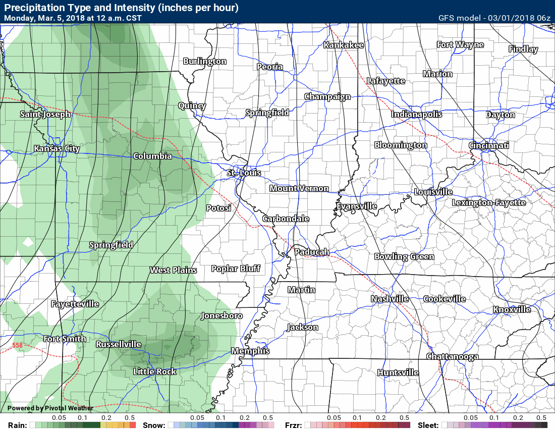
Here is the future-cast GFS radar for the Sunday night into Monday event.
What might radar look like Sunday night and Monday?
Timestamp upper left.
.
.
Rainfall totals of 0.20″ to 0.40″ are anticipated with the Sunday night and Monday event. This is still several days away, so I will monitor trends in case we see an uptick in the rain totals. We definitely do not need more rain.
The preliminary spring and summer forecast has been posted on the subscription website. Subscribe at www.beaudodsonweather.com
Spring and Summer outlook – Click here
Need to check the latest river crest forecast? Click here.
.

.

.
We offer regional radars and local city radars – if a radar does not update then try another one. Occasional browsers need their cache cleared. You may also try restarting your browser. This will usually fix any problems.
Need to check the latest river crest forecast? Click here.
.


We offer regional radars and local city radars – if a radar does not update then try another one. Occasional browsers need their cache cleared. You may also try restarting your browser. This will usually fix any problems.
During the winter you can track snow and ice by clicking the winterize button on the local city view interactive radars.
You may email me at beaudodson@usawx.com
Interactive Weather Radar Page. Choose the city nearest your location: Click this link
National interactive radar: Click this link.