We have some great sponsors for the Weather Talk Blog. Please let our sponsors know that you appreciate their support for the Weather Talk Blog.
Milner and Orr Funeral Home and Cremation Services located in Paducah, Kentucky and three other western Kentucky towns – at Milner and Orr they believe in families helping families. You can find Milner and Orr on Facebook, as well.
![]()
.

For all of your families eye care needs. Visit their web-site here. Or, you can also visit their Facebook page.
.

Best at Enabling Body Shop Profitability since 1996. Located In Paducah Kentucky and Evansville Indiana; serving all customers in between. They provide Customer Service, along with all the tools necessary for body shops to remain educated and competitive. Click the logo above for their main web-site. You can find McClintock Preferred Finishes on Facebook, as well

Expressway Carwash and Express Lube are a locally owned and operated full service Carwash and Lube established in 1987. We have been proudly serving the community for 29 years now at our Park Avenue location and 20 years at our Southside location. We have been lucky enough to partner with Sidecar Deli in 2015, which allows us to provide our customers with not only quality service, but quality food as well. . If you haven’t already, be sure to make Expressway your one stop shop, with our carwash, lube and deli. For hours of operation and pricing visit www.expresswashlube.com or Expressway Carwash on Facebook.

TORNADO SHELTERS! Endrizzi’s Storm Shelters – For more information click here. Endrizzi Contracting and Landscaping can be found on Facebook, as well – click here
I have launched the new weather texting service! I could use your help. Be sure and sign up and fully support all of the weather data you see each day.
This is a monthly subscription service. Supporting this helps support everything else. The cost is $3 a month for one phone, $5 a month for three phones, and $10 a month for seven phones.
For more information visit BeauDodsonWeather.com
Or directly sign up at Weathertalk.com


This forecast update covers far southern Illinois, far southeast Missouri, and far western Kentucky. See the coverage map on the right side of the blog.
Remember that weather evolves. Check back frequently for updates, especially during active weather.

.
Monday Night – Increasing clouds from the north. Less humid. A period of scattered thunderstorms.
What impact is expected? Perhaps isolated wet roadways and lightning. Gusty winds near storms.
Temperatures: Lows in the 58-64 degree range
Winds: Winds west and northwest at 5 mph.
What is the chance for precipitation? 40%
Coverage of precipitation: Scattered
Is severe weather expected? No
My confidence in this part of the forecast verifying is High
Should I cancel my outdoor plans? No
.
Tuesday. A few morning clouds. Then, sunshine. Only a 10% chance for precipitation Tuesday morning over northwest Kentucky.
What impact is expected? Most likely none. I will be monitoring a storm system to our north.
Temperatures: High temperatures in the 76-82 degree range.
Winds: Northwest and north winds at 7-14 mph and gusty at times.
What is the chance for precipitation? 10%
Coverage of precipitation? None to isolated.
Is severe weather expected? No
My confidence in this part of the forecast verifying is High
Should I cancel my outdoor plans? No
Sunrise will be at 5:34 a.m. and sunset will be at 8:13 p.m.
UV index will be 9-10. Very high.
Moonrise will be at 8:17 a.m. and moonset will be at 10:37 p.m. Waxing crescent
Tuesday Night – Clearing. Nice temperatures. Less humid. Patchy fog possible.
What impact is expected? None
Temperatures: Lows in the 55-60 degree range
Winds: Winds north/northwest at 3-6 mph.
What is the chance for precipitation? 0%
Coverage of precipitation: None.
Is severe weather expected? No
My confidence in this part of the forecast verifying is High
Should I cancel my outdoor plans? No
.
Wednesday – Patchy morning fog possible. Partly to mostly sunny. A few clouds possible.
What impact is expected? None
Temperatures: High temperatures in the 76-84 degree range
Winds: North and northwest winds at 6-12 mph
What is the chance for precipitation? 0%
Coverage of precipitation? None
Is severe weather expected? No
My confidence in this part of the forecast verifying is High
Should I cancel my outdoor plans? No
Sunrise will be at 5:34 a.m. and sunset will be at 8:13 p.m.
UV index will be 9-10. Very high.
Moonrise will be at 9:19 a.m. and moonset will be at 11:22 p.m. Waxing crescent
Wednesday Night – Mostly clear.
What impact is expected? None
Temperatures: Lows in the 58-64 degree range
Winds: Winds north or variable at 4-8 mph.
What is the chance for precipitation? 0%
Coverage of precipitation: None
Is severe weather expected? No
My confidence in this part of the forecast verifying is High
Should I cancel my outdoor plans? No
.
Thursday – A mix of sun and clouds. More humid.
What impact is expected? Most likely none
Temperatures: High temperatures in the 82-84 degree range
Winds: South and southeast winds at 6-12 mph
What is the chance for precipitation? 10%
Coverage of precipitation? None to perhaps isolated
Is severe weather expected? No
My confidence in this part of the forecast verifying is High
Should I cancel my outdoor plans? No
Sunrise will be at 5:34 a.m. and sunset will be at 8:14 p.m.
UV index will be 9-10. Very high.
Moonrise will be at 10:19 a.m. and moonset will be at 12:01 a.m. Waxing crescent
Thursday Night – Partly cloudy. A thunderstorm or two can’t be ruled out.
What impact is expected? Isolated chance for wet roadways and lightning.
Temperatures: Lows in the 64-68 degree range
Winds: Winds south and southwest at 4-8 mph.
What is the chance for precipitation? 20%
Coverage of precipitation: Isolated
Is severe weather expected? No
My confidence in this part of the forecast verifying is High
Should I cancel my outdoor plans? No
.
Friday – A mix of sun and clouds. Very warm. Humid. Breezy, at times.
What impact is expected? Most likely none. I will be monitoring for slight thunderstorm chances.
Temperatures: High temperatures in the 86-92 degree range (assuming we do not have a lot of clouds). Temperatures could rise into the lower 90s with plenty of sunshine.
Winds: Southwest and west winds at 7-14 mph. Gusts to 15 mph.
What is the chance for precipitation? 10%
Coverage of precipitation? Isolated
Is severe weather expected? No
My confidence in this part of the forecast verifying is High
Should I cancel my outdoor plans? No
Sunrise will be at 5:34 a.m. and sunset will be at 8:14 p.m.
UV index will be 9-10. Very high.
Moonrise will be at 11:19 a.m. and moonset will be at 12:01 a.m. Waxing crescent
Friday Night – Partly cloudy. Warm.
What impact is expected? None
Temperatures: Lows in the 68-74 degree range
Winds: Winds southwest at 5-10 mph.
What is the chance for precipitation? <10%
Coverage of precipitation: Isolated
Is severe weather expected? No
My confidence in this part of the forecast verifying is High
Should I cancel my outdoor plans? No
.
Saturday – Partly cloudy. Hot and humid.
What impact is expected? Heat index should rise into the 90’s to perhaps around 100 degrees.
Temperatures: High temperatures in the 88-94 degree range
Winds: South and southwest winds at 7-14 mph with gusts to 20 mph.
What is the chance for precipitation? <10%
Coverage of precipitation? Likely none
Is severe weather expected? No
My confidence in this part of the forecast verifying is High
Should I cancel my outdoor plans? No, but it might be hot.
Saturday Night – Partly cloudy. Warm. Humid.
What impact is expected? None
Temperatures: Lows in the 66-74 degree range
Winds: Winds west/southwest at 5-10 mph.
What is the chance for precipitation? <10%
Coverage of precipitation: Most likely none
Is severe weather expected? No
My confidence in this part of the forecast verifying is High
Should I cancel my outdoor plans? No
.
Sunday – Partly sunny. Breezy, at times. Hot and humid. A scattered thunderstorm possible.
What impact is expected? Heat index should reach into the 90’s to perhaps 100 degrees. A stray thunderstorm could produce wet roadways and lightning.
Temperatures: High temperatures in the 90-95 degree range
Winds: Southwest and west winds at 7-14 mph. Gusty.
What is the chance for precipitation? 20%
Coverage of precipitation? Isolated to perhaps scattered
Is severe weather expected? No
My confidence in this part of the forecast verifying is Low
Should I cancel my outdoor plans? No, but monitor radars
Sunday Night – Partly cloudy. Warm and humid. A thunderstorm possible.
What impact is expected? Perhaps wet roadways and lightning
Temperatures: Lows in the 70-75 degree range
Winds: Winds variable at 5-10 mph.
What is the chance for precipitation? 20%
Coverage of precipitation: Isolated
Is severe weather expected? No
My confidence in this part of the forecast verifying is Low
Should I cancel my outdoor plans? No, but monitor radars in case a storm pops up
.
Monday – Partly sunny. Muggy. A scattered thunderstorm possible.
What impact is expected? Perhaps some wet roadways and lightning.
Temperatures: High temperatures in the 86-92 degree range. Heat index into the 90s.
Winds: South winds at 7-14 mph
What is the chance for precipitation? 20%
Coverage of precipitation? Isolated to perhaps scattered.
Is severe weather expected? No
My confidence in this part of the forecast verifying is Low
Should I cancel my outdoor plans? No
Monday Night – Partly cloudy. A scattered thunderstorm possible.
What impact is expected? Wet roadways and lightning
Temperatures: Lows in the 68-74 degree range
Winds: Winds south at 5-10 mph.
What is the chance for precipitation? 20%
Coverage of precipitation: Isolated to scattered
Is severe weather expected? No
My confidence in this part of the forecast verifying is Low
Should I cancel my outdoor plans? No
.
Tuesday – Partly sunny. Warm. Muggy. A thunderstorm possible.
What impact is expected? Wet roadways and lightning
Temperatures: High temperatures in the 84-88 degree range
Winds: Southwest winds at 7-14 mph. Gusts to 20 mph.
What is the chance for precipitation? 30%
Coverage of precipitation? Scattered
Is severe weather expected? Monitor updates
My confidence in this part of the forecast verifying is Low
Should I cancel my outdoor plans? No, but monitor updates
Tuesday Night – Partly cloudy. Thunderstorms possible.
What impact is expected? Wet roadways and lightning
Temperatures: Lows in the 65-70 degree range
Winds: Winds south and southwest at 5-10 mph.
What is the chance for precipitation? 30%-40%
Coverage of precipitation: Scattered
Is severe weather expected? Monitor updates
My confidence in this part of the forecast verifying is Low
Should I cancel my outdoor plans? No, but monitor updates
.
Wednesday – Partly sunny. Warm. A thunderstorm possible.
What impact is expected? Wet roadways and lightning.
Temperatures: High temperatures in the 84-88 degree range
Winds: Northwest winds at 6-12 mph
What is the chance for precipitation? 30%
Coverage of precipitation? Scattered
Is severe weather expected? Not at this time
My confidence in this part of the forecast verifying is Low
Should I cancel my outdoor plans? No, but monitor updates
Wednesday Night – Partly cloudy. Cooler.
What impact is expected? Perhaps wet roadways and lightning
Temperatures: Lows in the 64-68 degree range
Winds: Winds west and northwest at 5-10 mph.
What is the chance for precipitation? 30%
Coverage of precipitation: Scattered
Is severe weather expected? Not at this time
My confidence in this part of the forecast verifying is Low
Should I cancel my outdoor plans? No, but monitor updates
.
Thursday – Partly to mostly sunny. A few clouds possible.
What impact is expected? None
Temperatures: High temperatures in the 76-84 degree range
Winds: North and northeast winds at 6-12 mph
What is the chance for precipitation? 0%
Coverage of precipitation? None
Is severe weather expected? No
My confidence in this part of the forecast verifying is Low
Should I cancel my outdoor plans? No
Sunrise will be at 5:14 a.m. and sunset will be at 8:28 p.m.
UV index will be 9-10. Very high.
Moonrise will be at 4:54 a.m. and moonset will be at 3:02 a.m. Waxing Gibbous
Thursday Night – Mostly clear.
What impact is expected? None
Temperatures: Lows in the 60-65 degree range
Winds: Winds variable at 5-10 mph.
What is the chance for precipitation? 0%
Coverage of precipitation: None
Is severe weather expected? No
My confidence in this part of the forecast verifying is Low
Should I cancel my outdoor plans? No
.
Friday – Partly to mostly sunny.
What impact is expected? None
Temperatures: High temperatures in the 82-86 degree range
Winds: Southeast winds at 5-10 mph
What is the chance for precipitation? 0%
Coverage of precipitation? None
Is severe weather expected? No
My confidence in this part of the forecast verifying is Low
Should I cancel my outdoor plans? No
Sunrise will be at 5:34 a.m. and sunset will be at 8:17 p.m.
UV index will be 9. Very high.
Moonrise will be at 5:46 p.m. and moonset will be at 3:49 a.m.
Friday Night – Mostly clear.
What impact is expected? None
Temperatures: Lows in the 60-65 degree range
Winds: Winds south at 5-10 mph.
What is the chance for precipitation? 0%
Coverage of precipitation: None
Is severe weather expected? No
My confidence in this part of the forecast verifying is High
Should I cancel my outdoor plans? No
.
The weekend forecast is sponsored by Farmer and Company Real Estate.

Farmer & Company Real Estate is proud to represent buyers and sellers in both Southern Illinois and Western Kentucky. With 13 licensed brokers, we can provide years of experience to buyers & sellers of homes, land & farms and commercial & investment properties. We look forward to representing YOU! Follow us on Facebook, as well
The weekend forecast is sponsored by Farmer and Company Real Estate. Click here to visit their site.


Don’t forget to check out the Southern Illinois Weather Observatory web-site for weather maps, tower cams, scanner feeds, radars, and much more! Click here

An explanation of what is happening in the atmosphere over the coming days…
- Fast moving system on Monday night. Thunderstorm?
- Nice weather Tuesday into Thursday. Cooler for a couple of days.
- Hot and humid. First heat wave of the season?
- Strong cold front early next week
Well, today has been beautiful! Wish this would have happened on Saturday. At least we had a nice day on Sunay. Hope you were able to enjoy today’s weather.
A fast moving weather system will brush our region tonight. It will approach from the north. A few scattered showers and thunderstorms will be possible. Lightning is the main concern. Severe weather is not anticipated.
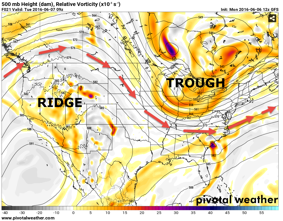
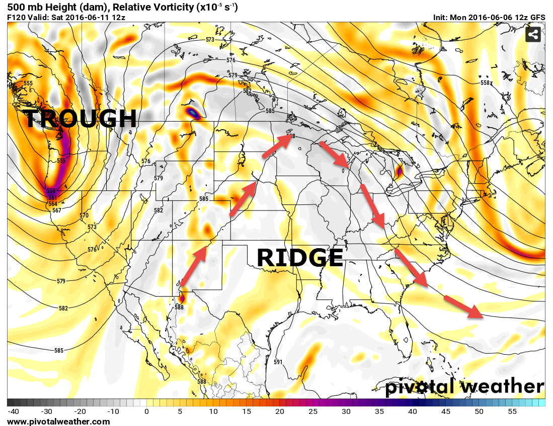
You can see the troughs and ridges on these next two maps. Watch the change. The first map shows you the 500 mb level for heights and vorticity. The colors represent where some lift might be occurring. An indication, depending on the placement of the vorts, for rain and storms.
This first one is for Tuesday morning. A disturbance passes through our region and to the northeast of our region. See the red lines? Those are indicating which direction the wind flow will be during the time frame indicated. We will have northwest flow on Tuesday. Winds aloft will be coming out of the northwest. The jet stream is dipping into our area. A trough normally means cooler weather and sometimes unsettled weather. It will mean cooler weather for our region.
Now, look at the second map. See the big difference? A ridge of high pressure builds into our region. These ridges, during the summer months, can mean hot and humid weather. And, they typically suppress thunderstorm activity. Our winds will be coming out of the southwest and south. The second map is for Friday and Saturday. Hot weather is expected because of this ridge of high pressure.
What is a trough and a ridge? Here you go – click here
Tuesday and Wednesday will deliver beautiful spring weather. High temperatures in the 70s to middle 80s. Nice for this time of the year. Not anticipating any precipitation on Tuesday into Wednesday.
We will start to warm up on Thursday. Another weak disturbance moves through our area on Thursday night and Friday morning. Another chance for a couple of thunderstorms in the region. Confidence is low on that part of the forecast.
A mini-heat wave arrives on Friday into Monday. I am currently forecasting widespread 90s for Saturday and Sunday. It will feel hot and it will feel humid. All of the recent rainfall won’t help our cause. That will only make it feel more uncomfortable.
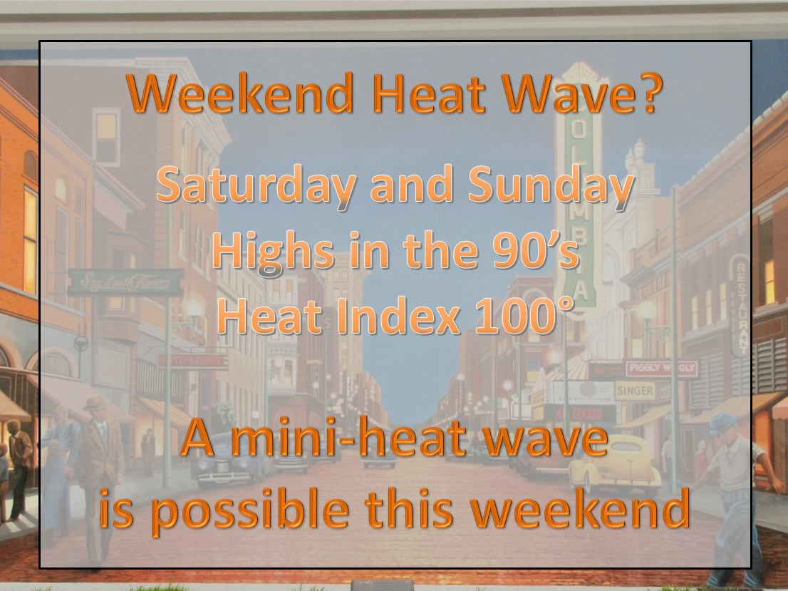
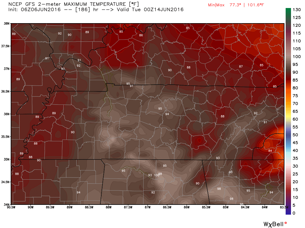
The hottest day might be Sunday. I can’t rule out middle 90s. Guidance has been trending warmer. You can see my forecast numbers above. They are hot. I consider hot weather to be 90 degrees and above. Heat index values might hit 100 degrees this weekend.
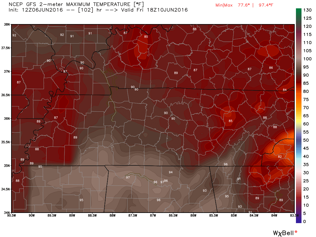
Here is what the GFS guidance is showing for high temperatures Saturday into Monday.
Click images for larger view. Weatherbell.com images
Friday high temperatures
Saturday highs
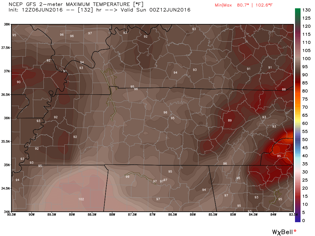
Sunday highs
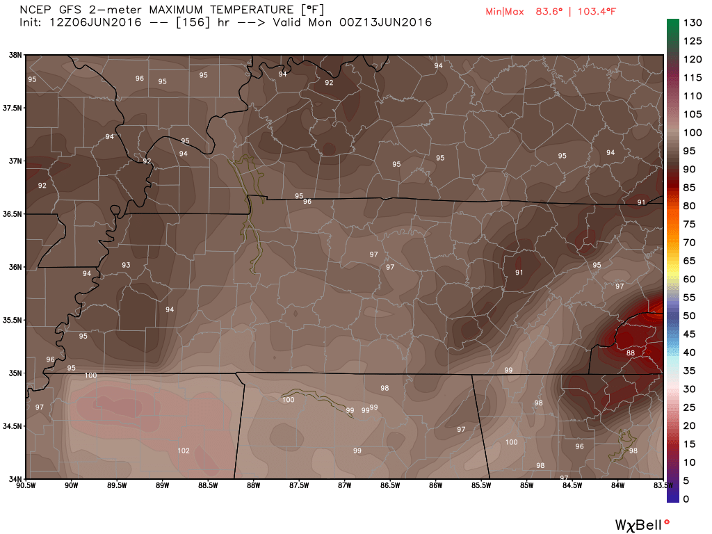
Monday highs
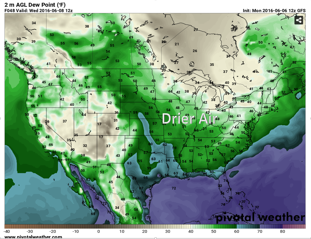
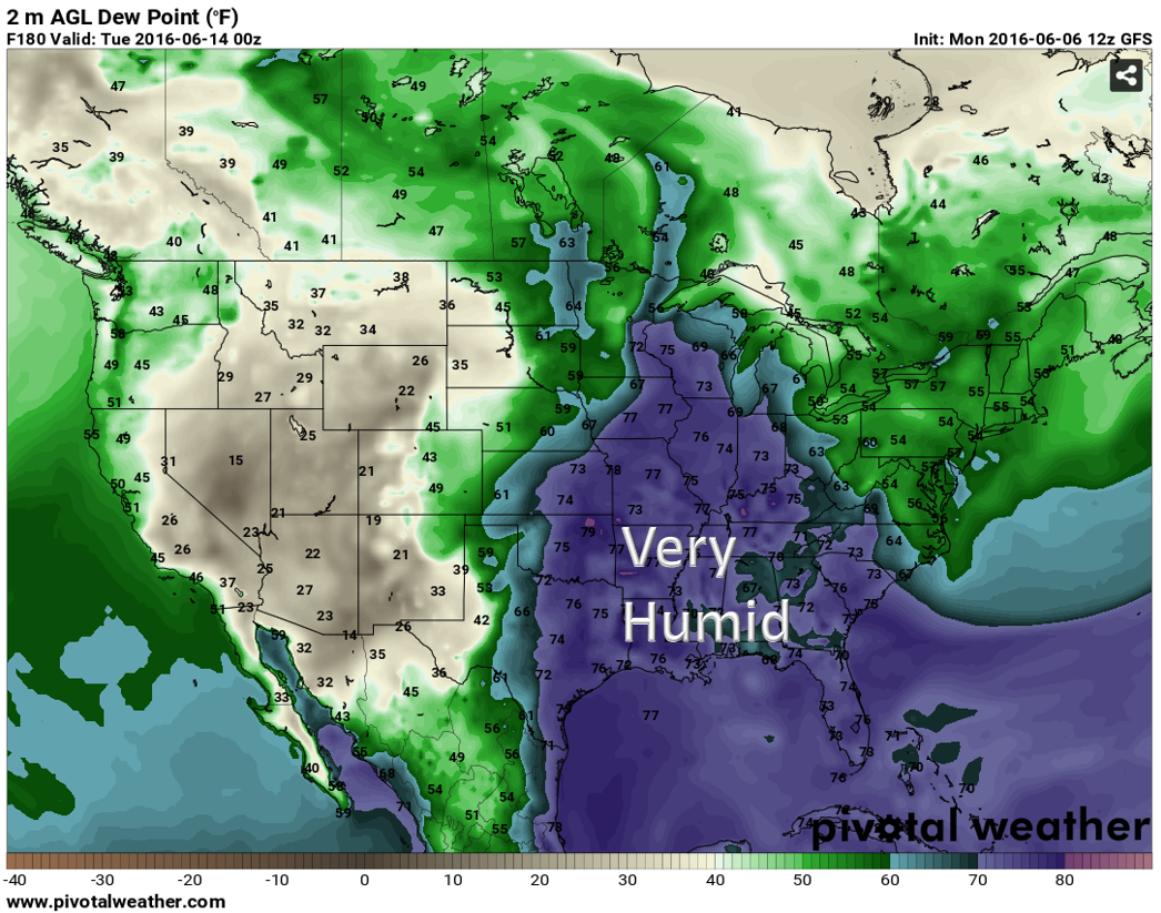
Watch the change in dew points. Dew points are a great way to measure moisture in the air. Better than humidity. To learn more about dew points you can click here. When the dew points rise into the 60’s it will start to feel humid outside. When they reach 70 degrees or above you can expect to feel uncomfortable. Very humid and sticky. The atmosphere feels muggy.
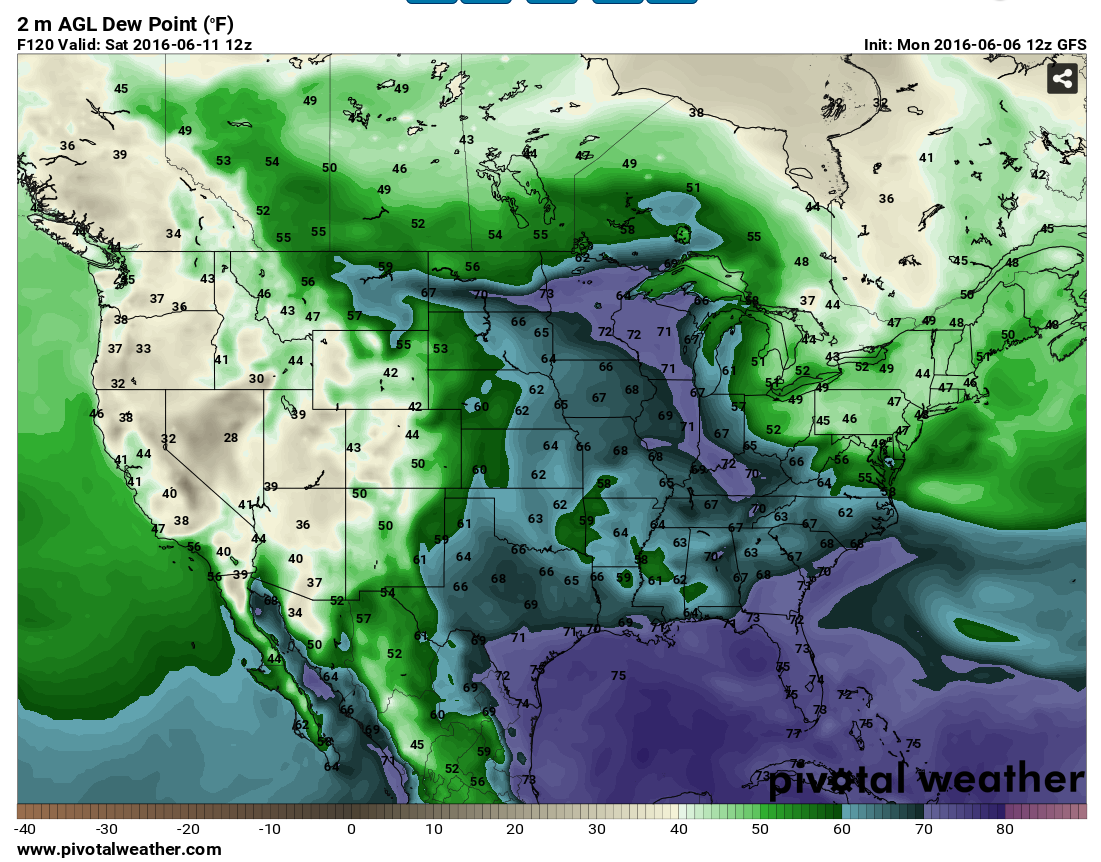
Here is the dew point map for Tuesday. Notice the 50’s over our region? Drier air. Should feel nicer outside on Tuesday and Wednesday.
But, watch what happens by Friday and Saturday. OUCH! Dew points jump into the 60’s and perhaps even 70’s.
Early next week the dew points are expected to be very high. Into the 70’s. Muggy. That means air that you wear (as Jim Rasor says). Very humid. Lot of fuel for storms, as well. We will have to monitor the cold front moving into the region early next week (assuming it does move into the area).
Early next week, a strong cold front is anticipated to bump into the hot air. This would occur on Monday or Tuesday of next week. Long way off for a forecaster. But, that is what I will be tracking. Thunderstorms will erupt along and ahead of the cold front. Some disagreement on where to place the strongest wind fields on Monday and Tuesday. I suspect somewhere from Iowa/Wisconsin/Missouri/Illinois/Indiana/Michigan will be under the threat of heavy rain and strong storms. Too far off for solid specifics. But, that is what I am tracking. Monitor updates.
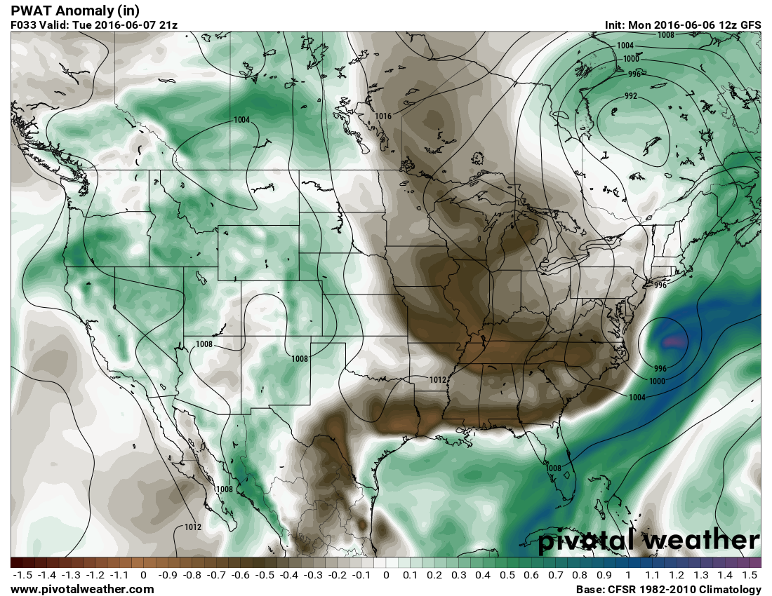
Here are the PWAT values for Tuesday and then early next week. These are the PWAT anomalies. How much above or below normal will they be. PWAT values are a GREAT way to measure the moisture of the entire atmosphere (top to bottom). Notice brown colors on Tuesday. Dry air. Notice the blue and greens next week. Moisture will be plentiful for any storms that form.
and then next week
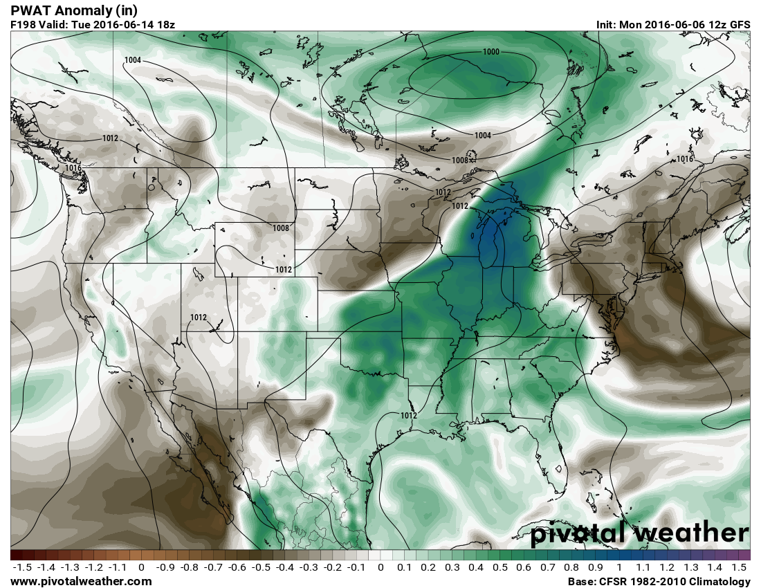
Cooler weather is anticipated behind next weeks cold front.
Radar


We have regional radars and local city radars – if a radar does not seem to be updating then try another one. Occasional browsers need their cache cleared. You may also try restarting your browser. That usually fixes the problem. Occasionally we do have a radar go down. That is why I have duplicates. Thus, if one fails then try another one.
If you have any problems then please send me an email beaudodson@usawx.com
WEATHER RADAR PAGE – Click here —
We also have a new national interactive radar – you can view that radar by clicking here.
Local interactive city radars include St Louis, Mt Vernon, Evansville, Poplar Bluff, Cape Girardeau, Marion, Paducah, Hopkinsville, Memphis, Nashville, Dyersburg, and all of eastern Kentucky – these are interactive radars. Local city radars – click here

Live Lightning Data – zoom and pan: Click here
Live Lightning Data with sound (click the sound button on the left side of the page): Click here

Can we expect severe thunderstorms over the next 24 to 48 hours? Remember that a severe thunderstorm is defined as a thunderstorm that produces 58 mph winds or higher, quarter size hail or larger, and/or a tornado.
.
Monday night: Perhaps a thunderstorm. Non-severe.
Tuesday-Friday: Severe weather is not anticipated. Small chance for a thunderstorm on Thursday night and Friday.
Next Saturday-Sunday: Should be dry
Sunday night into Wednesday: Thunderstorms are possible. Monitor updates.
.

.
I increased temperatures for the weekend. I did not change much concerning the rain forecast.
.

.
No major concerns. A couple of thunderstorms possible Monday night. Lightning would be the main concern.
.

.
No
.

How much precipitation should we expect over the next few days?
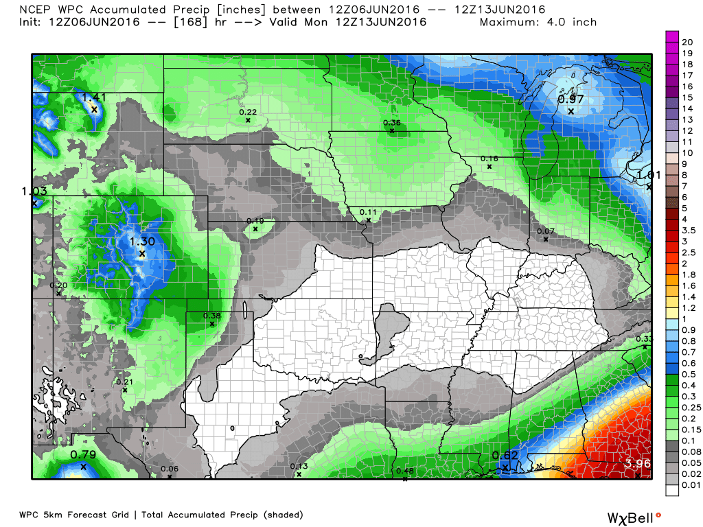
A couple of storms possible on Monday night. Rainfall totals of 0.40″ or less. Another chance Thursday night. Low confidence. Heavier rain will be possible next week.

Here are the current river stage forecasts. You can click your state and then the dot for your location. It will bring up the full forecast and hydrograph.
..

Here is the official 6-10 day and 8-14 day temperature and precipitation outlook. Check the date stamp at the top of each image (so you understand the time frame).
The forecast maps below are issued by the Weather Prediction Center (NOAA).


The latest 8-14 day temperature and precipitation outlook. Note the dates are at the top of the image. These maps DO NOT tell you how high or low temperatures or precipitation will be. They simply give you the probability as to whether temperatures or precipitation will be above or below normal.


Who do you trust for your weather information and who holds them accountable?
I have studied weather in our region since the late 1970’s. I have 37 years of experience in observing our regions weather patterns. My degree is in Broadcast Meteorology from Mississippi State University and an Associate of Science (AS). I am currently working on my Bachelor’s Degree in Geoscience.
My resume includes:
Member of the American Meteorological Society.
NOAA Weather-Ready Nation Ambassador.
Meteorologist for McCracken County Emergency Management. I served from 2005 through 2015.
I own and operate the Southern Illinois Weather Observatory.
Recipient of the Mark Trail Award, WPSD Six Who Make A Difference Award, Kentucky Colonel, and the Caesar J. Fiamma” Award from the American Red Cross.
In 2009 I was presented with the Kentucky Office of Highway Safety Award.
Recognized by the Kentucky House of Representatives for my service to the State of Kentucky leading up to several winter storms and severe weather outbreaks.
I am also President of the Shadow Angel Foundation which serves portions of western Kentucky and southern Illinois.
There is a lot of noise on the internet. A lot of weather maps are posted without explanation. Over time you should learn who to trust for your weather information.
My forecast philosophy is simple and straight forward.
- Communicate in simple terms
- To be as accurate as possible within a reasonable time frame before an event
- Interact with you on Twitter, Facebook, and the blog
- Minimize the “hype” that you might see on television or through other weather sources
- Push you towards utilizing wall-to-wall LOCAL TV coverage during severe weather events
I am a recipient of the Mark Trail Award, WPSD Six Who Make A Difference Award, Kentucky Colonel, and the Caesar J. Fiamma” Award from the American Red Cross. In 2009 I was presented with the Kentucky Office of Highway Safety Award. I was recognized by the Kentucky House of Representatives for my service to the State of Kentucky leading up to several winter storms and severe weather outbreaks.
If you click on the image below you can read the Kentucky House of Representatives Resolution.

Many of my graphics are from www.weatherbell.com – a great resource for weather data, model data, and more


You can sign up for my AWARE email by clicking here I typically send out AWARE emails before severe weather, winter storms, or other active weather situations. I do not email watches or warnings. The emails are a basic “heads up” concerning incoming weather conditions.