We have some great sponsors for the Weather Talk Blog. Please let our sponsors know that you appreciate their support for the Weather Talk Blog.
Milner and Orr Funeral Home and Cremation Services located in Paducah, Kentucky and three other western Kentucky towns – at Milner and Orr they believe in families helping families. You can find Milner and Orr on Facebook, as well.
![]()
Check out our sponsors! There are more on the right side bar of the page, as well. Be sure and let them know that you appreciate their sponsorship of the WeatherTalk daily weather bulletin.

Wortham Dental Care located in Paducah, Kentucky. The gentle dentist. Mercury free dentistry. They also do safe Mercury removal. You can find Wortham Dental Care on Facebook, as well

Trover’s Equipment and Lawn Care – Family owned and operated! They are a dealer for Snapper, Simplicity, Snapper Pro, Bad Boy Mowers, and Intimidator Utility Vehicles. They are a Stihl and Dolmar power products dealer. They also are a dealer for Briggs & Stratton, Kohler gas & diesel engines, and Kawasaki engines. They service and repair just about any brand. You can find them on Facebook, as well

Visit their web-site here. Or, you can also visit their Facebook page.

Endrizzi’s Storm Shelters – For more information click here. Endrizzi Contracting and Landscaping can be found on Facebook, as well – click here

Gary Eckelkamp’s web-site click the above banner or click here
.

This forecast update covers far southern Illinois, far southeast Missouri, and far western Kentucky. See the coverage map on the right side of the blog.
Remember that weather evolves. Check back frequently for updates, especially during active weather.
The forecast numbers below may vary a bit across the region. These are the averages.
Thursday night – Some showers and thunderstorms possible over southeast Missouri, mainly. Then another chance late tonight moving in from the northwest. Overnight lows in the 60’s with light winds.
Friday – Partly to mostly cloudy. A 40%-60% chance for showers and thunderstorms. Highs in the 80’s with southwest winds at 5-10 mph.
My confidence in this part of the forecast verifying is medium
Should I cancel my outdoor plans? Some storms possible. Have a backup plan.
Morning School Bus Stop Weather – Some clouds with a chance for a thunderstorm. Mild with temperatures in the 60’s. Light winds.
—————————————————————————————-
Afternoon School Bus Stop Weather – Warm and humid. A chance for a storm. Temperatures in the 80’s with light winds.
Friday night – Cloudy. A 40%-60% chance for some showers and thunderstorms. Mild with temperatures in the 60’s for overnight lows. Winds variable at 5-10 mph.
My confidence in this part of the forecast verifying is medium
Should I cancel my outdoor plans? Some storms possible. Have a back up plan.
Saturday – Partly sunny and warm. A bit humid. A chance for a morning thunderstorm and then a 20% chance for an afternoon thunderstorm. Highs in the lower 80’s to middle 80’s (depending on cloud cover). Variable winds at 5-10 mph.
My confidence in this part of the forecast verifying is medium
Should I cancel my outdoor plans? Saturday morning could have some storms in the region. I believe Saturday afternoon will only bring a 20% chance for a popup storm at any given spot. I would not cancel plans.
Saturday night – Partly cloudy with a 10%-20% chance for a thunderstorm. Warm and humid. Lows near 68 degrees. East/southeast winds at 5-10 mph.
My confidence in this part of the forecast verifying is high
Should I cancel my outdoor plans? No, but monitor radars for a popup thunderstorm.
Sunday – Partly sunny and very warm. Humid. A 10%-20% chance for a thunderstorm. Perhaps better chances towards evening. Southwest winds at 10 mph.
My confidence in this part of the forecast verifying is medium
Should I cancel my outdoor plans? No, but monitor radars in case some storms form in the afternoon.
Storm chances increase to 40%60% late Sunday night and Monday.
Don’t forget you can check out my Facebook page to ask questions.
![]()
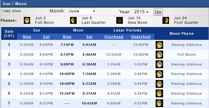
Sunrise and Sunset Times – Click Here


The School Bus Stop Forecast is sponsored by TransAmerica Agency Network Paducah District – you can visit their Facebook page here and their home page here

Current Temperatures Around The Local Area


Don’t forget to check out the Southern Illinois Weather Observatory web-site for weather maps, tower cams, scanner feeds, radars, and much more! Click here

An explanation of what is happening in the atmosphere over the coming days…
Highlights
1. I have some advertisement spots open. If you are interested then please contact me. You will be mentioned on Facebook, as well as the ad within this blog.
2. Thunderstorm chances on Friday and Friday night
3. How about the weekend?
Welcome to the weekend! We have some chances for showers and thunderstorms over the coming days.
The best chance will be Friday into Friday night. Then another round on Sunday night (perhaps late) and Monday. Perhaps most of Saturday and Sunday will be dry. I have placed 10%-20% chances for thunderstorms in the weekend forecast.
Saturday morning will need to be monitored for a little better chance for showers and thunderstorms. Late morning into afternoon less chances.
If you have outdoor events then check radar from time to time. It will be warm and a bit on the muggy side. Sunday has the potential to be very warm. If we can maximize sunshine on Sunday then middle to upper 80’s are possible. It will feel like summer.
How about temperatures? Highly dependent on cloud cover, but I will give it my best shot.
Friday high temperature map

Saturday high temperature map

Sunday high temperature map

Let’s look at some interesting maps
MCS season is here. An MCS is a large mass of thunderstorms that typically form at night and are fed by the low level jet. They reach they peak late at night and then slowly die out during the morning and afternoon hours. They normally leave outflow boundaries. Dying thunderstorms push air downward and outward. These are called outflow boundaries. These boundaries are where new storms can form in the heat of the day.
These types of systems are common in June and July. Here is a satellite view of the MCS complexes on Wednesday night and Thursday morning. They tracked into Missouri and then moved southward.
You are looking at satellite photograph with the radar overlayed on top. The bright red colors are very cold cloud tops. Thunderstorms are cumulonimbus clouds. Very high in the atmosphere. Thus, they are very cold.

Cross section of a cumulonimbus cloud. When a storm is that high in the atmosphere it has very cold cloud tops. The IR satellite above has colors that represent temperatures. Red is actually very cold.
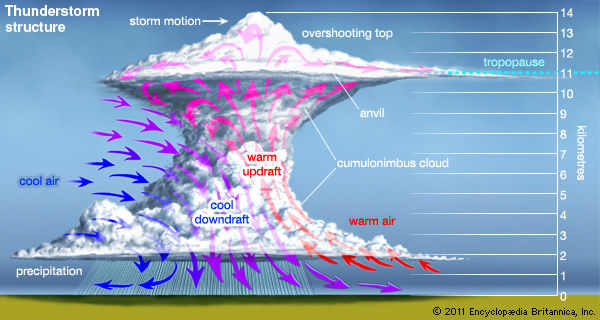
Here is a visible satellite image showing the Thursday morning storm complexes. You can see the wispy cirrus clouds over Nebraska. You can see two very large thunderstorm clusters on this image. See the overshooting tops on the satellite? The bulging white areas coming out of the storm complexes. See the diagram above for what an overshooting top is.
Click image for a larger view.

Here is a lesson on Mesoscale Convective Systems. Read it and learn more about these fascinating weather events.
http://www.wxonline.info/topics/mcs.html
These systems typically move around the outer edges of ridges of high pressure. The brown lines on the map below represent 500 mb heights. See how they are curving into our region? The center of this ridge is over Texas. It curves outward (temperatures aloft) into the Central United States.
See how the storms on this image are moving along that curved boundary?
The blue arrows are 500 mb wind barbs. The storms will typically follow the 500 mb wind field. Thus, these storms moving east and then southeast. Then, as they moved into our region, they moved southward.
Click image for a larger view

I can also pull out a bit more and show you the ridge better. The brown lines represent 500 mb heights. Warm temperatures aloft curving into our region and the Missouri Valley. Follow the clouds around the edge of the ridge. This is where MCS’s will setup shop and move. When the ridge weakens then we stand a better chance for rain and storms in our region. When the ridge strengthens then we have less to worry about in our region.


This section of the blog is speculative forecast information. Because it is past the range of what meteorologists can forecast accurately, it should be considered speculation. Anything past day 5 is considered a long range forecast.
Highlights
1. A cold front arrives on Sunday night and Monday with showers and thunderstorms
2. Watching Hurricane Blanca and where the moisture from it moves
3. Watching Gulf of Mexico for activity down the road
A cold front will push into the region on Sunday night and Monday. Showers and thunderstorms will accompany the front. Locally heavy rain will be possible in a few spots. This time of the year is known for heavy downpours. Plenty of moisture to work with.
Severe weather potential appears limited Sunday night through next Wednesday, but the heavy rain potential is there.
The front will sag south of our region by Monday night or Tuesday. If the front stalls out over our region then shower and storm chances will linger. Right now some models push it south and some models hang it up. Normally cold front have a hard time pushing southward during the Month of June. So, it could very well find itself stuck somewhere over or near our region. Eventually it would likely wash out.
Let’s look at a few maps
These maps are from weatherbell.com
This is the GFS model. The green represents precipitation. The cold front will be to our north on Sunday evening. You can see the stretch of green precipitation. This will move south on Sunday evening and night. Some showers and storms right over our region, as well.
This map is for 7 am on Monday morning.

Moving forward to Monday night…you can see showers and thunderstorms draped along the cold front over our region. Again, some questions as to whether the front stalls out over our region or not. Remember me talking about this subject earlier this week in the summer forecast.

By Tuesday night the GFS attempts to hold the front up over our region. This is up for debate. But, let’s keep an eye on it. Heavy rain would be a concern along a stalled out front.

Let me show you something of interest
This maps shows you the moisture from Hurricane Blanca. This is the Tuesday PWAT value forecast. PWAT values are how meteorologists measure moisture in the whole column of the atmosphere. The higher the number the more moisture available for storms.
Look over the Baja of California. See Hurricane Blanca or the remnants of Blanca? That moisture will push into the southwest United States next week. That is the forecast, at least. Eventually some of the moisture could move into the Central United States and find itself caught up along a cold front. This will need to be monitored. It might enhance precipitation a bit. Occasionally this type of setup can cause flash flooding in the United States.
PWAT value map is from wright-weather.com
What are PWAT values? Great question! I found this blog post that explains it quite well. Click here for more information on PWAT values.

Here is the GFS PWAT value forecast for late next week (next Friday night…June 15th). That is a cold front over the Central United States. See the curl into Iowa? That is an area of low pressure centered over Iowa and Illinois…pulling moisture northward. Some of the moisture is likely from the remnants of the hurricane that is forecast to come out of the Pacific Ocean. Assuming the system does track into the southwest United States.

Also, of interest
Will a possible tropical system for along the coast of Mexico or Texas in the long range? If so then that will need to be monitored for additional heavy rain concerns for parts of the U.S.
This would match the analog years that were made for the summer forecast. A June tropical system moving into Texas.
You can see it here on the GFS model. Look down in the Gulf of Mexico (western side). Long shot forecast? We will see what happens. This is the June 15th weather map.

Radars
WEATHER RADAR PAGE – Click here —

I also set up a storm tracking page with additional links (use during active weather for quick reference)
Storm Tracking Tool Page
Don’t forget to support our sponsors!

No major weather concerns. Thunderstorms are possible on Friday and Friday night. Lightning and heavy downpours would be the main concern for outdoor events. Severe weather risk is low.

If you have an outdoor event on Friday/Friday night then monitor radars. Chances go up again on Sunday evening. Right now most of Saturday and Sunday look pretty good. A few scattered storms possible, but widespread storms are not forecast for Saturday late morning through Sunday afternoon.

Here are the current river stage forecasts. You can click your state and then the dot for your location. It will bring up the full forecast and hydrograph.
Click Here For River Stage Forecasts…

The wild card tells you where the uncertainties are in the forecast
Wild card in this forecast – the wild card in the forecast will be thunderstorm chances on Saturday and Sunday. The push of precipitation should center on Friday and Friday night. Small chance Saturday morning. Then better chances again Sunday night into Tuesday. That leaves a question mark from Saturday morning into Sunday afternoon. Small chances, it appears for a popup thunderstorm.

Can we expect severe thunderstorms over the next 24 to 48 hours? Remember that a severe thunderstorm is defined as a thunderstorm that produces 58 mph winds or higher, quarter size hail or larger, and/or a tornado.
Thunderstorm threat level is TWO. Some storms are possible on Friday and Friday night. Small risk for strong storms. Not overly concerned about severe weather. But, some gusty winds possible with the most intense storms that form. Lightning is always a concern, of course…for outdoor events.
Anyone with outdoor events should monitor radars and lightning data. Even though a thunderstorm might not be severe, it could certainly cause problems if you have an outdoor sporting event or are camping.
Friday Severe Weather Outlook – Some thunderstorms possible
Saturday Severe Weather Outlook – Can’t rule out some thunderstorms
Sunday Severe Weather Outlook – Some storms possible Sunday evening and night
Monday Severe Weather Outlook – Can’t rule out some thunderstorms
Tuesday Severe Weather Outlook – Can’t rule out some thunderstorms


How much precipitation should we expect over the next few days?
As we enter the late spring and summer months, keep in mind that slow moving thunderstorms can always produce locally heavy rainfall totals. This is no secret to all of you who are farmers. Your neighbors could pick up 1″ of rain from a thunderstorm, meanwhile you are sitting on dry ground. Forecasting exact rainfall totals during this time of the year can be tricky, at best.
We have several chances for showers and thunderstorms over the coming days. Any thunderstorms that form in this environment could produce locally heavy rain. That makes it tricky to forecast totals for your house. Between now and Monday night most of us should pick up 0.25″-0.50″ of rain. There is a lower than normal confidence on this rainfall forecast.
Some spots will pick up 1-2″ of rain in thunderstorms. I believe the best chance for this happening will be over parts of southeast Missouri and northern parts of southern Illinois. This will be highly dependent on the exact placement of each complex of thunderstorms that move through the region. Again, low confidence.
Here is the rainfall total forecast through Monday night. Broad-brushed


We have regional radars and local city radars – if a radar does not seem to be updating then try another one. Occasional browsers need their cache cleared. You may also try restarting your browser. That usually fixes the problem. Occasionally we do have a radar go down. That is why I have duplicates. Thus, if one fails then try another one.
If you have any problems then please send me an email beaudodson@usawx.com
WEATHER RADAR PAGE – Click here —
We also have a new national interactive radar – you can view that radar by clicking here.
Local interactive city radars include St Louis, Mt Vernon, Evansville, Poplar Bluff, Cape Girardeau, Marion, Paducah, Hopkinsville, Memphis, Nashville, Dyersburg, and all of eastern Kentucky – these are interactive radars. Local city radars – click here
NOTE: Occasionally you will see ground clutter on the radar (these are false echoes). Normally they show up close to the radar sites – including Paducah.

Regional Radar – Click on radar to take you our full radar page.


Regional Radar

Live Lightning Data – zoom and pan: Click here
Live Lightning Data with sound (click the sound button on the left side of the page): Click here
I also set up a storm tracking page with additional links (use during active weather for quick reference)
Storm Tracking Tool Page

For the most up to date maps – click here


![]()
Current WARNINGS (a warning means take action now). Click on your county to drill down to the latest warning information. Keep in mind that there can be a 2-3 minute delay in the updated warning information.
I strongly encourage you to use a NOAA Weather Radio or warning cell phone app for the most up to date warning information. Nothing is faster than a NOAA weather radio.


Color shaded counties are under some type of watch, warning, advisory, or special weather statement. Click your county to view the latest information.

Missouri Warnings

Illinois Warnings

Kentucky Warnings

Here is the official 6-10 day and 8-14 day temperature and precipitation outlook. Check the date stamp at the top of each image (so you understand the time frame).
The forecast maps below are issued by the Weather Prediction Center (NOAA).


The latest 8-14 day temperature and precipitation outlook. Note the dates are at the top of the image. These maps DO NOT tell you how high or low temperatures or precipitation will be. They simply give you the probability as to whether temperatures or precipitation will be above or below normal.


Who do you trust for your weather information and who holds them accountable?
I have studied weather in our region since the late 1970’s. I have 37 years of experience in observing our regions weather patterns. My degree is in Broadcast Meteorology from Mississippi State University and an Associate of Science (AS). I am currently working on my Bachelor’s Degree in Geoscience. Just need to finish two Spanish classes!
I am a member of the American Meteorological Society. I am a NOAA Weather-Ready Nation Ambassador. And, I am the Meteorologist for McCracken County Emergency Management.
I own and operate the Southern Illinois Weather Observatory.
There is a lot of noise on the internet. A lot of weather maps are posted without explanation. Over time you should learn who to trust for your weather information.
My forecast philosophy is simple and straight forward.
- Communicate in simple terms
- To be as accurate as possible within a reasonable time frame before an event
- Interact with you on Twitter, Facebook, and the blog
- Minimize the “hype” that you might see on television or through other weather sources
- Push you towards utilizing wall-to-wall LOCAL TV coverage during severe weather events
I am a recipient of the Mark Trail Award, WPSD Six Who Make A Difference Award, Kentucky Colonel, and the Caesar J. Fiamma” Award from the American Red Cross. In 2009 I was presented with the Kentucky Office of Highway Safety Award. I was recognized by the Kentucky House of Representatives for my service to the State of Kentucky leading up to several winter storms and severe weather outbreaks.
If you click on the image below you can read the Kentucky House of Representatives Resolution.

I am also President of the Shadow Angel Foundation which serves portions of western Kentucky and southern Illinois.

Many of my graphics are from www.weatherbell.com – a great resource for weather data, model data, and more


This blog was inspired by ABC 33/40’s Alabama Weather Blog – view their blog
Current tower cam view from the Weather Observatory- Click here for all cameras.

Southern Illinois Weather Observatory

The Weather Observatory

Southern Illinois Weather Observatory
WSIL TV 3 has a number of tower cameras. Click here for their tower camera page & Illinois Road Conditions

Marion, Illinois
WPSD TV 6 has a number of tower cameras. Click here for their tower camera page & Kentucky Road Conditions & Kentucky Highway and Interstate Cameras

Downtown Paducah, Kentucky
Benton, Kentucky Tower Camera – Click here for full view

Benton, Kentucky

I24 Paducah, Kentucky

I24 Mile Point 9 – Paducah, KY

I24 – Mile Point 3 Paducah, Kentucky

You can sign up for my AWARE email by clicking here I typically send out AWARE emails before severe weather, winter storms, or other active weather situations. I do not email watches or warnings. The emails are a basic “heads up” concerning incoming weather conditions.