We have some great sponsors for the Weather Talk Blog. Please let our sponsors know that you appreciate their support for the Weather Talk Blog.
Milner and Orr Funeral Home and Cremation Services located in Paducah, Kentucky and three other western Kentucky towns – at Milner and Orr they believe in families helping families. You can find Milner and Orr on Facebook, as well.
![]()
Check out our sponsors! There are more on the right side bar of the page, as well. Be sure and let them know that you appreciate their sponsorship of the WeatherTalk daily weather bulletin.

Wortham Dental Care located in Paducah, Kentucky. The gentle dentist. Mercury free dentistry. They also do safe Mercury removal. You can find Wortham Dental Care on Facebook, as well

Trover’s Equipment and Lawn Care – Family owned and operated! They are a dealer for Snapper, Simplicity, Snapper Pro, Bad Boy Mowers, and Intimidator Utility Vehicles. They are a Stihl and Dolmar power products dealer. They also are a dealer for Briggs & Stratton, Kohler gas & diesel engines, and Kawasaki engines. They service and repair just about any brand. You can find them on Facebook, as well

Visit their web-site here. Or, you can also visit their Facebook page.

Endrizzi’s Storm Shelters – For more information click here. Endrizzi Contracting and Landscaping can be found on Facebook, as well – click here

Gary Eckelkamp’s web-site click the above banner or click here
.

This forecast update covers far southern Illinois, far southeast Missouri, and far western Kentucky. See the coverage map on the right side of the blog.
Remember that weather evolves. Check back frequently for updates, especially during active weather.
The forecast numbers below may vary a bit across the region. These are the averages.
The rest of today and tonight – Some clouds. Scattered locally heavy showers and thunderstorms. Temperatures will fall into the lower 70’s by morning. Southerly and southwesterly winds at 10 mph.
Monday – Partly cloudy. Warm. Humid. Thunderstorms once again possible. Typical June weather pattern. Highs around 86 to 92 degrees. Southerly/southwesterly winds at 10 mph. Storms that form could produce heavy rain and gusty winds.
Should I cancel my outdoor plans? I would not cancel plans, but I would definitely monitor radars from time to time.
My confidence in this part of the forecast verifying is high
What is the chance for precipitation? 40%
What impact is expected? Where storms do occur there will be heavy downpours, lightning, and 30-40 mph wind gusts. Small chance for pea to nickel size hail
Monday night – Some clouds with showers and thunderstorms possible. Some storms will produce heavy downpours and gusty winds.
My confidence in this part of the forecast verifying is high
Should I cancel my outdoor plans? No. But, check radars from time to time
What is the chance for precipitation? 30%
What impact is expected? Where storms do occur there could be heavy downpours, lightning, and 30-40 mph wind gusts. Small chance for pea to nickel size hail.
Tuesday – Partly cloudy with scattered showers and thunderstorms possible. Locally heavy rain possible where storms occur. Highs in the 80’s with southerly winds at 10 mph.
My confidence in this part of the forecast verifying is medium
Should I cancel my outdoor plans? Monitor radars from time to time. I would not cancel plans.
What is the chance for precipitation? 40%-50%
What impact is expected? Where storms do occur there could be heavy downpours, lightning, and 30-40 mph wind gusts. Small chance for pea to nickel size hail
Tuesday night – Partly cloudy with scattered showers and thunderstorms possible, once again. Mainly early.
My confidence in this part of the forecast verifying is high
Should I cancel my outdoor plans? I would not cancel plans. Just check radars from time to time if you have concerns.
Is severe weather expected? No
What is the chance for precipitation? 30%
What impact is expected? Where storms do occur there could be heavy downpours, lightning, and 30-40 mph wind gusts. Small chance for pea to nickel size hail
Wednesday – Increasingly cloudy. A chance for rain and thunderstorms. Much of the Wednesday into Friday forecast will depend on what happens with the system coming out of the Gulf of Mexico. Where it tracks will be key to our local weather. Confidence is lower than normal. Highs in the 80’s. Variable winds at 10-15 mph.
My confidence in this part of the forecast verifying is low
Should I cancel my outdoor plans? Monitor updates
Is severe weather expected? Not at this time, but monitor updates.
What is the chance for precipitation? 40%
What impact is expected? Locally heavy rain, lightning, and gusty winds will be possible.
![]()
Sunrise and Sunset Times – Click Here


Don’t forget to check out the Southern Illinois Weather Observatory web-site for weather maps, tower cams, scanner feeds, radars, and much more! Click here

An explanation of what is happening in the atmosphere over the coming days…
Highlights
1. Unsettled pattern for much of the new work week
2. Warm and humid into Thursday
3. Long range discussion centers around the potential tropical system or moisture moving into the Gulf of Mexico
4. I have some advertiser or sponsorship spots available on the blog and on Facebook. Contact me for details at beaudodson@usawx.com
Monday will bring more of the same. Warm and humid weather with occasional showers and heavy thunderstorms. Some of you have missed out on the rain over the last couple of days. Some of you have ended up with several inches of rain.
This is typical for June and July. Summer months always bring scattered heavy thunderstorms. The storms pulse up and produce torrential downpours, gusty winds, and even small hail. Occasionally a wind gust will bring down a tree branch or tree. But, widespread severe weather is not expected on Monday or Tuesday.
Flash flooding can occur where storms train over the same areas. We have seen this over the past week across parts of southern Illinois. Same will be true over the coming days.
Not a big fan of the broken record forecast. But, it is what it is. Scattered storms over the coming days. Some of you will once again miss out…some of you will pick up a few inches of rain.
Highs will be in the 80’s to lower 90’s. Cloud cover will always be the wild card in the temperature department. More clouds and a few storms and temperatures will be knocked down a few notches.
I will be keeping a close eye on the tropics. See the extended discussion for more details.
Did you know I had a ton of weather maps for you to explore on my web-site? Click here

This section of the blog is speculative forecast information. Because it is past the range of what meteorologists can forecast accurately, it should be considered speculation. Anything past day 5 is considered a long range forecast.
Highlights
1. All eyes on the tropics
2. Perhaps a bit calmer weather after the tropical system passes through the region?
3. Cooler towards the end of the month? Or no?
4. How is July shaping up?
Well, all eyes are certainly now on the tropics. I started talking about this concern back on June 1st. More than 2 weeks ago. Now every meteorologist is talking about it. The pattern favored a lot of tropical moisture moving into the Central United States. Pattern recognition is a favorite forecasting method of determining what might happen based on analog years. What happened in the past, in other words.
The real question is whether this thing even fully develops. Will it become a tropical storm or hurricane? If so, where does it then move? All important questions when it comes to making a forecast call on what happens locally. Then the question becomes…where does it track? It could miss our local area or it could move right over us. Models show a variety of solution.
Some data takes the system into Kansas and northwest Missouri. Other data takes the system much further south and east. Too far out to say where it tracks. Wherever it tracks there will be locally heavy rain.
I would not be surprised if this system intensified over land. Why? For a few reasons. One is great inflow for the system. Favorable outflow and perhaps because the ground over Oklahoma and Texas is warm and moist. Some debate among meteorologists on this topic. We will see what happens as it moves inland.
Here is the latest WPC NOAA rainfall forecast for the rest of the new work week. Again, where this system tracks is key to how this map verifies. Any shift west or east will change the numbers. BIG numbers for a huge chunk of real estate. Click to enlarge. Map is produced by weatherbell.com

Here is the high resolution NAM model. You can see the system in the Gulf of Mexico moving ashore in Texas. This seems almost certain to happen. How strong will it be? That is one question on the table.
Image is from weatherbell.com
This is for Monday night at 7 pm

By Tuesday night at 7 pm the system is moving inland. You can see it over Texas and Oklahoma/Arkansas.

But where does it swirl after that? I am thinking someone in Missouri and Illinois picks up 2-4″ of rain with locally 6″ of rain. Right now I am leaning towards southwest and south central Missouri into central and eastern Missouri and then into parts of central Illinois and perhaps northern parts of southern Illinois.
South and east of there will also have to deal with some very heavy thunderstorms.
Keep in mind that nothing is set in stone. Some other models bring it right over our local counties.
Here is a high resolution tropical model from weatherbell.com
Just look at how well organized the system is on this model.
This is for Thursday morning. This model depicts high winds over parts of our region…especially western counties. It also depicts very heavy rain along the track of the system.
Historically systems like this have caused some problems. Occasionally they can produce damaging winds well inland. Will that happen with this one? Too soon to say. It may not even track over or near our region. Data is all over the place with the eventual track.
These type of systems are notoriously difficult to forecast days in advance (track).

Then on Thursday afternoon the same model shows this. You can see this model believes the heaviest rains will stay a bit to our north.

Some of the precipitation maps for the system. You can see where it tracks based on total precipitation. Rainfall forecast map from NCEP GFS from weatherbell.com
Those are some 5-8″ totals over parts of Missouri and Illinois. If the model is correct.

Let’s zoom in on the GFS model. This is one idea. Does not mean it will be correct or exact. But, I want you to see the potential of this thing. Click image to read the numbers better. This is from the GFS model from Hazwx.com

Here is another model (similar to the above GFS but tweaked a bit differently). It comes up with a similar solution

Keep in mind that nothing is set in stone. Some other models bring it right over our local counties.
What has already started over the past few days…
What has already happened is that deep moisture from the Pacific Ocean and the Gulf of Mexico/Caribbean has spread into the southern and central United States. This deep moisture has already been responsible for extremely heavy rainfall totals in some areas.
Let’s look at PWAT values. PWAT values is how meteorologists measure moisture/deep moisture in the atmosphere. This is a better gauge of how much moisture is contained in all levels of the atmosphere (not just the surface). When you start seeing 1.5 and 2.0″ numbers (for this time of the year) then the atmosphere is juiced up.
When the atmosphere is juiced up you can experience very heavy rainfall totals in short periods of time.
Let’s look at Monday through Thursday. Some of these numbers will depend on the track of the tropical system. Does it or does it not develop?
Images are from wright-weather.com
Here is the Monday PWAT value map

Here is the Tuesday night PWAT value map

Here is the Wednesday night PWAT value map

Here is the Thursday PWAT value map. That is a lot of moisture to work with.

Finally, on Friday. See how the numbers drop dramatically behind the system on Thursday? The lower numbers would mean drier air.

Parts of southern Illinois have picked up 1″-7″+ of rain over the past 7-10 days. Very heavy downpours will continue to be a concern over the coming week. If slow moving thunderstorms train over the same areas then you can expect to pick up 1-2″ per hour in the rainfall department.
Parts of northern Illinois (another pick area in my long range forecast for heavy rain) has picked up 5-10″ of rain in the past week or so. Big amounts!
IF the tropical system moves towards the Missouri and Ohio Valleys then we will expect a more general and widespread rain event. Some of the rain will be heavy. Gusty winds can also accompany these systems and brief short lived tornadoes. But, will that impact our region? Not sure, yet. Stay tuned as I continue to monitor the path of the tropical system or its moisture.
Beyond this system…perhaps some calmer weather down the road? Appears after the system moves through our region we might dry out for a few days (I say dry out for those who have been picking up rain).
There are mixed signals on the end of the month. Some of the data is showing a cooler shot of air and some of the analog forecasts are showing warmer than normal. Isn’t that just peachy. Now, which one should I go with?
How about July?
June didn’t turn out exactly as planned. Yes, in the rainfall department it has been about as expected (for most). But, for temperatures…it has been warmer than expected.
A lot of signals are pointing towards cooler than normal temperatures in July. That is a stretch for our region. It is hard for cold fronts to push this far south. But, that is what the signals are showing. We will see if I can get the July forecast right. Cooler than normal is the forecast with a 40% confidence level. The concern (which was also the concern in June and we saw which one won out) is the southeast ridge. That ridge has been responsible for our warm temperatures over the past few weeks.
If you remember in the long range discussions…if the southeast ridge pokes into our region then we warm up. When it pushes away we end up with cooler than normal temperatures with rounds of thunderstorms. Once again we will play tug of war with the southeast ridge during July. Which will win? The trough to the north and west or the ridge in the east? Whichever one wins will determine what happens next. Grab the popcorn? Not that July weather is ever very exciting. Might as well have some popcorn to go with it.
Radars
WEATHER RADAR PAGE – Click here —

I also set up a storm tracking page with additional links (use during active weather for quick reference)
Storm Tracking Tool Page
Don’t forget to support our sponsors!

How much precipitation should we expect over the next few days?
As we enter the late spring and summer months, keep in mind that slow moving thunderstorms can always produce locally heavy rainfall totals. This is no secret to all of you who are farmers. Your neighbors could pick up 1″ of rain from a thunderstorm, meanwhile you are sitting on dry ground. Forecasting exact rainfall totals during this time of the year can be tricky, at best.
Same song and dance. Rainfall amounts will vary greatly across the region. We have experienced this for the last couple of weeks. Some places end up with buckets of rain and other areas remain dry. The same will be true on Monday.
A more widespread rain event is possible towards the middle and end of the week. Monitor updates. The track of the system is still questionable, at best.

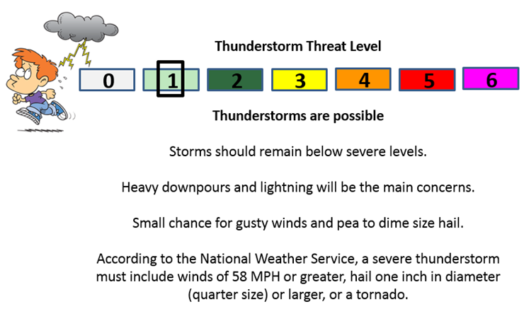
Can we expect severe thunderstorms over the next 24 to 48 hours? Remember that a severe thunderstorm is defined as a thunderstorm that produces 58 mph winds or higher, quarter size hail or larger, and/or a tornado.
Thunderstorm threat level is ONE. Some gusty storms will again be possible on Monday into at least Wednesday and Thursday.
Anyone with outdoor events should monitor radars and lightning data. Even though a thunderstorm might not be severe, it could certainly cause problems if you have an outdoor sporting event or are camping.
Monday Severe Weather Outlook – Some storms are possible, but they should remain below severe levels
Tuesday Severe Weather Outlook – Some storms are possible, but they should remain below severe levels
Wednesday Severe Weather Outlook – Some storms are possible, but they should remain below severe levels
Thursday Severe Weather Outlook – Some storms are possible, but they should remain below severe levels. Monitor updates concerning the track of the tropical system coming into the Gulf of Mexico.

The main concern continues to be centered around these heavy thunderstorms that form during the late morning and afternoon hours. Downpours of 1-2″ per hour can quickly cause some issues with street flooding and poorly drained areas.
Lightning is a concern, as always. Outdoor events should monitor radars.
Gusty winds with some of the storms. There have been a few reports over the recent days of wind damage to trees. Isolated.
I am watching a deep slug of moisture for later this week. Perhaps it will track somewhere near our region. But, where? That is the question.

Another case of better safe than sorry…throw an umbrella and rain jacket in the car. That is about the best advice! Some places will end up with a heavy downpour and other areas will remain mostly dry. Same pattern from the past few days.

Here are the current river stage forecasts. You can click your state and then the dot for your location. It will bring up the full forecast and hydrograph.
Click Here For River Stage Forecasts…

The wild card tells you where the uncertainties are in the forecast
Wild card in this forecast – The wild card in the forecast is an easy one. Where does all of the tropical moisture from the Gulf of Mexico spread over the coming week? We already have deep moisture over much of the southern and central United States. This is thanks to hurricane outs in the Pacific and a rich feed of moisture coming out of the Gulf of Mexico and Caribbean.
Any boundaries or systems that interact with all of this moisture will produce heavy thunderstorms.
Current Temperatures Around The Local Area


We have regional radars and local city radars – if a radar does not seem to be updating then try another one. Occasional browsers need their cache cleared. You may also try restarting your browser. That usually fixes the problem. Occasionally we do have a radar go down. That is why I have duplicates. Thus, if one fails then try another one.
If you have any problems then please send me an email beaudodson@usawx.com
WEATHER RADAR PAGE – Click here —
We also have a new national interactive radar – you can view that radar by clicking here.
Local interactive city radars include St Louis, Mt Vernon, Evansville, Poplar Bluff, Cape Girardeau, Marion, Paducah, Hopkinsville, Memphis, Nashville, Dyersburg, and all of eastern Kentucky – these are interactive radars. Local city radars – click here
NOTE: Occasionally you will see ground clutter on the radar (these are false echoes). Normally they show up close to the radar sites – including Paducah.

Regional Radar – Click on radar to take you our full radar page.


Regional Radar

Live Lightning Data – zoom and pan: Click here
Live Lightning Data with sound (click the sound button on the left side of the page): Click here
I also set up a storm tracking page with additional links (use during active weather for quick reference)
Storm Tracking Tool Page
![]()
Current WARNINGS (a warning means take action now). Click on your county to drill down to the latest warning information. Keep in mind that there can be a 2-3 minute delay in the updated warning information.
I strongly encourage you to use a NOAA Weather Radio or warning cell phone app for the most up to date warning information. Nothing is faster than a NOAA weather radio.


Color shaded counties are under some type of watch, warning, advisory, or special weather statement. Click your county to view the latest information.

Missouri Warnings

Illinois Warnings

Kentucky Warnings

Here is the official 6-10 day and 8-14 day temperature and precipitation outlook. Check the date stamp at the top of each image (so you understand the time frame).
The forecast maps below are issued by the Weather Prediction Center (NOAA).


The latest 8-14 day temperature and precipitation outlook. Note the dates are at the top of the image. These maps DO NOT tell you how high or low temperatures or precipitation will be. They simply give you the probability as to whether temperatures or precipitation will be above or below normal.


Who do you trust for your weather information and who holds them accountable?
I have studied weather in our region since the late 1970’s. I have 37 years of experience in observing our regions weather patterns. My degree is in Broadcast Meteorology from Mississippi State University and an Associate of Science (AS). I am currently working on my Bachelor’s Degree in Geoscience. Just need to finish two Spanish classes!
I am a member of the American Meteorological Society. I am a NOAA Weather-Ready Nation Ambassador. And, I am the Meteorologist for McCracken County Emergency Management.
I own and operate the Southern Illinois Weather Observatory.
There is a lot of noise on the internet. A lot of weather maps are posted without explanation. Over time you should learn who to trust for your weather information.
My forecast philosophy is simple and straight forward.
- Communicate in simple terms
- To be as accurate as possible within a reasonable time frame before an event
- Interact with you on Twitter, Facebook, and the blog
- Minimize the “hype” that you might see on television or through other weather sources
- Push you towards utilizing wall-to-wall LOCAL TV coverage during severe weather events
I am a recipient of the Mark Trail Award, WPSD Six Who Make A Difference Award, Kentucky Colonel, and the Caesar J. Fiamma” Award from the American Red Cross. In 2009 I was presented with the Kentucky Office of Highway Safety Award. I was recognized by the Kentucky House of Representatives for my service to the State of Kentucky leading up to several winter storms and severe weather outbreaks.
If you click on the image below you can read the Kentucky House of Representatives Resolution.

I am also President of the Shadow Angel Foundation which serves portions of western Kentucky and southern Illinois.

Many of my graphics are from www.weatherbell.com – a great resource for weather data, model data, and more


This blog was inspired by ABC 33/40’s Alabama Weather Blog – view their blog
Current tower cam view from the Weather Observatory- Click here for all cameras.

Southern Illinois Weather Observatory

The Weather Observatory

Southern Illinois Weather Observatory
WSIL TV 3 has a number of tower cameras. Click here for their tower camera page & Illinois Road Conditions

Marion, Illinois
WPSD TV 6 has a number of tower cameras. Click here for their tower camera page & Kentucky Road Conditions & Kentucky Highway and Interstate Cameras

Downtown Paducah, Kentucky
Benton, Kentucky Tower Camera – Click here for full view

Benton, Kentucky

I24 Paducah, Kentucky

I24 Mile Point 9 – Paducah, KY

I24 – Mile Point 3 Paducah, Kentucky

You can sign up for my AWARE email by clicking here I typically send out AWARE emails before severe weather, winter storms, or other active weather situations. I do not email watches or warnings. The emails are a basic “heads up” concerning incoming weather conditions.