We have some great sponsors for the Weather Talk Blog. Please let our sponsors know that you appreciate their support for the Weather Talk Blog.
Milner and Orr Funeral Home and Cremation Services located in Paducah, Kentucky and three other western Kentucky towns – at Milner and Orr they believe in families helping families. You can find Milner and Orr on Facebook, as well.
![]()
.

For all of your families eye care needs. Visit their web-site here. Or, you can also visit their Facebook page.
.

Best at Enabling Body Shop Profitability since 1996. Located In Paducah Kentucky and Evansville Indiana; serving all customers in between. They provide Customer Service, along with all the tools necessary for body shops to remain educated and competitive. Click the logo above for their main web-site. You can find McClintock Preferred Finishes on Facebook, as well

Expressway Carwash and Express Lube are a locally owned and operated full service Carwash and Lube established in 1987. We have been proudly serving the community for 29 years now at our Park Avenue location and 20 years at our Southside location. We have been lucky enough to partner with Sidecar Deli in 2015, which allows us to provide our customers with not only quality service, but quality food as well. . If you haven’t already, be sure to make Expressway your one stop shop, with our carwash, lube and deli. For hours of operation and pricing visit www.expresswashlube.com or Expressway Carwash on Facebook.

TORNADO SHELTERS! Endrizzi’s Storm Shelters – For more information click here. Endrizzi Contracting and Landscaping can be found on Facebook, as well – click here
I have launched the new weather texting service! I could use your help. Be sure and sign up and fully support all of the weather data you see each day.
This is a monthly subscription service. Supporting this helps support everything else. The cost is $3 a month for one phone, $5 a month for three phones, and $10 a month for seven phones.
For more information visit BeauDodsonWeather.com
Or directly sign up at Weathertalk.com


This forecast update covers far southern Illinois, far southeast Missouri, and far western Kentucky. See the coverage map on the right side of the blog.
Remember that weather evolves. Check back frequently for updates, especially during active weather.

.
Friday Night – Mostly clear. Warm.
What impact is expected? None
Temperatures: Lows in the 65-70 degree range
Winds: Winds south and southeast at 3-6 mph.
What is the chance for precipitation? <10%
Coverage of precipitation: None
Is severe weather expected? No
My confidence in this part of the forecast verifying is High
Should I cancel my outdoor plans? No
Sunset will be at 8:14 p.m.
Moonset will be at 12:36 a.m.
.
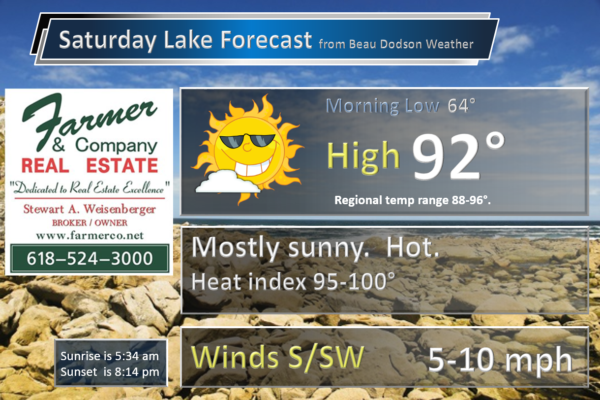
Saturday – Partly to mostly sunny. Hot and humid. Less than a 10% chance for a storm.
What impact is expected? Heat index should rise well into the 90s to perhaps 100 degrees.
Temperatures: High temperatures in the 90-96 degree range
Winds: South and southwest winds at 7-14 mph with gusts to 15-20 mph.
What is the chance for precipitation? <10%
Coverage of precipitation? None
Is severe weather expected? No
My confidence in this part of the forecast verifying is High
Should I cancel my outdoor plans? No, but it will be hot.
Sunrise will be at 5:34 a.m. and sunset will be at 8:14 p.m.
UV index will be 9-10. Very high.
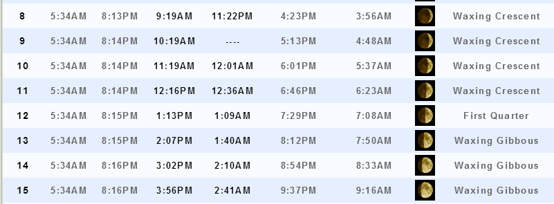
Moonrise will be at 12:16 p.m. and moonset will be at 12:36 a.m. Waxing crescent
Saturday Night – Partly cloudy. Warm. Humid.
What impact is expected? None
Temperatures: Lows in the 68-74 degree range
Winds: Winds west/southwest at 3-6 mph.
What is the chance for precipitation? <10%
Coverage of precipitation: None
Is severe weather expected? No
My confidence in this part of the forecast verifying is High
Should I cancel my outdoor plans? No
.
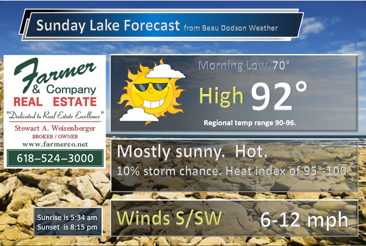
Sunday – Partly sunny. Breezy, at times. Hot and humid. An isolated thunderstorm possible.
What impact is expected? Heat index should reach into the 90’s to perhaps 102 degrees. A stray thunderstorm could produce wet roadways and lightning.
Temperatures: High temperatures in the 92-96 degree range
Winds: Southwest and west winds at 6-12 mph. Gusts to 15 mph.
What is the chance for precipitation? 10%-20%
Coverage of precipitation? None to perhaps isolated
Is severe weather expected? No
My confidence in this part of the forecast verifying is High
Should I cancel my outdoor plans? No
Sunrise will be at 5:34 a.m. and sunset will be at 8:15 p.m.
UV index will be 9-10. Very high.
Moonrise will be at 1:13 p.m. and moonset will be at 1:09 a.m. First quarter.
Sunday Night – Partly cloudy. Warm and humid. A chance for an isolated thunderstorm.
What impact is expected? Perhaps wet roadways and lightning (if anything at all)
Temperatures: Lows in the 70-75 degree range
Winds: Winds west/northwest at 4-8 mph.
What is the chance for precipitation? 10%-20%
Coverage of precipitation: Isolated
Is severe weather expected? No
My confidence in this part of the forecast verifying is High
Should I cancel my outdoor plans? No
.
Monday – Partly sunny. Muggy. A scattered thunderstorm possible.
What impact is expected? Perhaps isolated wet roadways and lightning.
Temperatures: High temperatures in the 90-95 degree range. Heat index into the upper 90s to around 100.
Winds: West/southwest winds at 7-14 mph
What is the chance for precipitation? 20%
Coverage of precipitation? Isolated to perhaps scattered.
Is severe weather expected? No
My confidence in this part of the forecast verifying is Medium
Should I cancel my outdoor plans? No
Sunrise will be at 5:34 a.m. and sunset will be at 8:15 p.m.
UV index will be 9-10. Very high.
Moonrise will be at 2:07 p.m. and moonset will be at 1:40 a.m. Waxing Gibbous.
Monday Night – Partly cloudy. A scattered thunderstorm possible.
What impact is expected? Perhaps some wet roadways and lightning
Temperatures: Lows in the 70-75 degree range
Winds: Winds southwest at 4-8 mph.
What is the chance for precipitation? 20%-30%
Coverage of precipitation: Isolated to scattered
Is severe weather expected? No.
My confidence in this part of the forecast verifying is High
Should I cancel my outdoor plans? No
.
Tuesday – Partly sunny. Warm. Muggy. Scattered showers and thunderstorms possible.
What impact is expected? Wet roadways and lightning
Temperatures: High temperatures in the 86-94 degree range
Winds: Southwest winds at 7-14 mph. Gusts to 18 mph.
What is the chance for precipitation? 40%
Coverage of precipitation? Scattered
Is severe weather expected? Monitor updates.
My confidence in this part of the forecast verifying is Medium
Should I cancel my outdoor plans? No, but monitor radars.
Sunrise will be at 5:34 a.m. and sunset will be at 8:16 p.m.
UV index will be 7-8. Moderate/High.
Moonrise will be at 3:02 p.m. and moonset will be at 2:10 a.m. Waxing Gibbous.
Tuesday Night – Partly cloudy. Showers and thunderstorms possible.
What impact is expected? Wet roadways and lightning
Temperatures: Lows in the 66-74 degree range
Winds: Winds south and southwest at 5-10 mph.
What is the chance for precipitation? 40%-50%
Coverage of precipitation: Scattered to perhaps numerous
Is severe weather expected? Monitor updates
My confidence in this part of the forecast verifying is Medium
Should I cancel my outdoor plans? No, but monitor radars.
.
Wednesday – Partly sunny. Warm and humid. Showers and thunderstorms possible.
What impact is expected? Wet roadways and lightning.
Temperatures: High temperatures in the 86-912 degree range
Winds: Southwest winds at 6-12 mph
What is the chance for precipitation? 40%-50%
Coverage of precipitation? Scattered to numerous
Is severe weather expected? Monitor updates
My confidence in this part of the forecast verifying is Medium
Should I cancel my outdoor plans? No, but monitor updates
Sunrise will be at 5:34 a.m. and sunset will be at 8:16 p.m.
UV index will be 7-8. Moderate/High.
Moonrise will be at 3:56 p.m. and moonset will be at 2:41 a.m. Waxing Gibbous.
Wednesday Night – Partly cloudy. A shower or thunderstorm possible.
What impact is expected? Perhaps wet roadways and lightning
Temperatures: Lows in the 65-70 degree range
Winds: Winds southwest at 5-10 mph.
What is the chance for precipitation? 40%-50%
Coverage of precipitation: Scattered
Is severe weather expected? Monitor updates
My confidence in this part of the forecast verifying is Medium
Should I cancel my outdoor plans? No, but monitor updates
.
Low confidence as we move into the end of next week. Some data continues rain chances into all of Thursday, Friday, Saturday, Sunday, and Monday of the following week. I will be monitoring guidance trends.
% chances will increase if confidence grows in the overall pattern. Keep that in mind. I never go with high % numbers this far out into the future. I ramp up with time. A 30% chance for precipitation in the long range is actually fairly high.
Thursday – Partly to mostly sunny. A thunderstorm possible.
What impact is expected? Wet roadways and lightning. Low confidence.
Temperatures: High temperatures in the 85-90 degree range
Winds: Southwest winds at 6-12 mph
What is the chance for precipitation? 40%
Coverage of precipitation? Isolated
Is severe weather expected? No
My confidence in this part of the forecast verifying is Low
Should I cancel my outdoor plans? No, but monitor radars.
Sunrise will be at 5:34 a.m. and sunset will be at 8:16 p.m.
UV index will be 8-9. High.
Moonrise will be at 4:51 p.m. and moonset will be at 3:14 a.m. Waxing Gibbous
Thursday Night – Partly cloudy. Thunderstorms possible.
What impact is expected? Possibly wet roadways and lightning
Temperatures: Lows in the 64-68 degree range
Winds: Winds variable at 5-10 mph.
What is the chance for precipitation? 30%-40%
Coverage of precipitation: Scattered
Is severe weather expected? No
My confidence in this part of the forecast verifying is Low
Should I cancel my outdoor plans? No
.
Friday – Partly sunny. Showers and thunderstorms possible.
What impact is expected? Possibly wet roadways and lightning
Temperatures: High temperatures in the 80-86 degree range
Winds: West winds at 5-10 mph
What is the chance for precipitation? 30%-40%
Coverage of precipitation? Scattered
Is severe weather expected? No
My confidence in this part of the forecast verifying is Low
Should I cancel my outdoor plans? No
Sunrise will be at 5:34 a.m. and sunset will be at 8:17 p.m.
UV index will be 7. Medium to high.
Moonrise will be at 5:46 p.m. and moonset will be at 3:49 a.m. Waxing Gibbous.
Friday Night – Partly cloudy. Thunderstorms possible.
What impact is expected? Possibly wet roadways and lightning
Temperatures: Lows in the 60-66 degree range
Winds: Winds west at 5-10 mph.
What is the chance for precipitation? 30%
Coverage of precipitation: Scattered
Is severe weather expected? No
My confidence in this part of the forecast verifying is Low
Should I cancel my outdoor plans? No
.
Saturday – Partly to sunny.
What impact is expected?
Temperatures: High temperatures in the 78-86 degree range
Winds: Northwest winds at 5-10 mph
What is the chance for precipitation? 20%-30%
Coverage of precipitation?
Is severe weather expected?
My confidence in this part of the forecast verifying is Low
Should I cancel my outdoor plans? No
Sunrise will be at 5:35 a.m. and sunset will be at 8:17 p.m.
UV index will be 6-7. Moderate.
Moonrise will be at 6:40 p.m. and moonset will be at 4:27 a.m. Waxing Gibbous.
Saturday Night – Partly cloudy.
What impact is expected?
Temperatures: Lows in the 60-66 degree range
Winds: Winds west at 5-10 mph.
What is the chance for precipitation? 20%-30%
Coverage of precipitation:
Is severe weather expected?
My confidence in this part of the forecast verifying is Low
Should I cancel my outdoor plans? No
.
Sunday – Partly to mostly sunny.
What impact is expected?
Temperatures: High temperatures in the 78-85 degree range
Winds: East winds at 5-10 mph
What is the chance for precipitation? 20%
Coverage of precipitation?
Is severe weather expected?
My confidence in this part of the forecast verifying is Low
Should I cancel my outdoor plans?
Sunrise will be at 5:34 a.m. and sunset will be at 8:17 p.m.
UV index will be 9-10. Very high.
Moonrise will be at 7:34 p.m. and moonset will be at 5:09 a.m. Waxing Gibbous.
Sunday Night – Mostly clear.
What impact is expected?
Temperatures: Lows in the 62-68 degree range
Winds: Winds south at 5-10 mph.
What is the chance for precipitation? 20%
Coverage of precipitation:
Is severe weather expected?
My confidence in this part of the forecast verifying is Low
Should I cancel my outdoor plans? No
.
Monday – Partly to mostly sunny.
What impact is expected?
Temperatures: High temperatures in the 78-86 degree range
Winds: East winds at 5-10 mph
What is the chance for precipitation? 10%
Coverage of precipitation?
Is severe weather expected?
My confidence in this part of the forecast verifying is Low
Should I cancel my outdoor plans? No
Sunrise will be at 5:35 a.m. and sunset will be at 8:17 p.m.
UV index will be 9-10. Very high.
Moonrise will be at 8:25 p.m. and moonset will be at 5:57 a.m. Full moon.
Monday Night – Mostly clear.
What impact is expected?
Temperatures: Lows in the 64-68 degree range
Winds: Winds south at 5-10 mph.
What is the chance for precipitation? <10%
Coverage of precipitation:
Is severe weather expected?
My confidence in this part of the forecast verifying is Low
Should I cancel my outdoor plans? No
.
The weekend forecast is sponsored by Farmer and Company Real Estate.

Farmer & Company Real Estate is proud to represent buyers and sellers in both Southern Illinois and Western Kentucky. With 13 licensed brokers, we can provide years of experience to buyers & sellers of homes, land & farms and commercial & investment properties. We look forward to representing YOU! Follow us on Facebook, as well
The weekend forecast is sponsored by Farmer and Company Real Estate. Click here to visit their site.


Don’t forget to check out the Southern Illinois Weather Observatory web-site for weather maps, tower cams, scanner feeds, radars, and much more! Click here

An explanation of what is happening in the atmosphere over the coming days…
- Here comes the heat!
- Thunderstorm chances?
- Slow moving system late next week?
- Another cool down in the charts
A hot and humid pattern is setting up shop across our region. That will mean temperatures in the upper 80’s to middle 90’s over the coming days. Expect the warmest days to be Sunday and Monday. I would not be surprised if a few spots top 95 degrees. Heat index values of 95-102 degrees will be common on Saturday, Sunday, and Monday. UV index will range from 8-10 over the coming days. Sun screen weather. Lake weather. Summer weather.
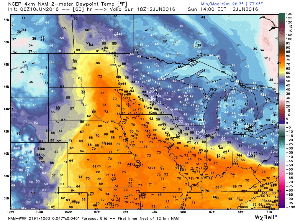
Here are the dew points for Sunday and Monday. You can see some 70’s showing up on the map. That would be muggy air. This is the Saturday afternoon dew point map. Click the image for a larger view.
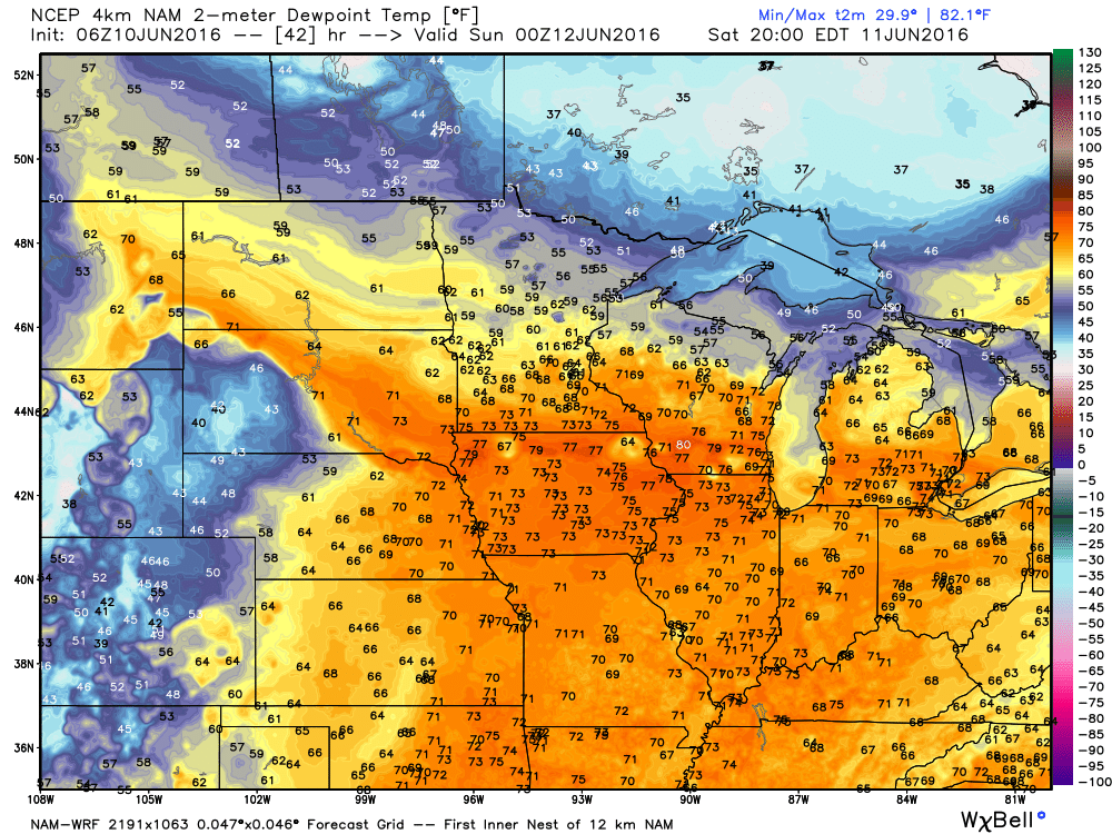
This is the Sunday afternoon image. Images are from weatherbell.com
A couple of storms could pop up on Sunday and Sunday night. Isolated, at best. Most areas will remain dry.
Thunderstorm chances will begin to increase on Monday and Tuesday. I am still forecasting precipitation chances to peak around Tuesday night/Wednesday. Perhaps centered on Wednesday. Rainfall totals could be heavy.
An unsettled pattern may develop from Wednesday night into Friday night. A slow moving upper level low is currently forecast to move slowly over our region. That would occur on Thursday and Friday. How fast the system exits is questionable. As long as the system remains over our region we will have thunderstorms in the forecast. I will taper chances on Friday night and Saturday of next week. But, confidence is low. Keep that in mind.
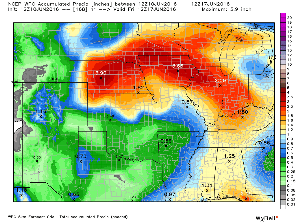
Isolated flash flooding is possible next week. PWAT values could top two inches. Those are very high numbers. Slow moving storms could produce 1-3″ of rain per hour. This is a typical pattern for summer. It is not unusual to experience isolated flash flooding from a system such as this. Widespread rainfall totals of 0.50″-1.00″ will be possible next week. And, as mentioned, some areas could experience a lot more rain. I won’t be surprised if some locations top three inches of rain between Monday and next Friday night.
There will also be a risk for frequent lightning and gusty thunderstorm winds. The overall severe weather risk won’t be zero, but it probably won’t be great, either. Isolated reports of wind damage could occur next week. Typical for June. Down burst winds. A bigger concern could be lightning. Again, typical for summer months.
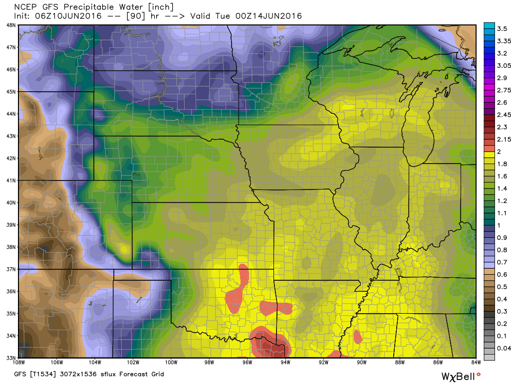
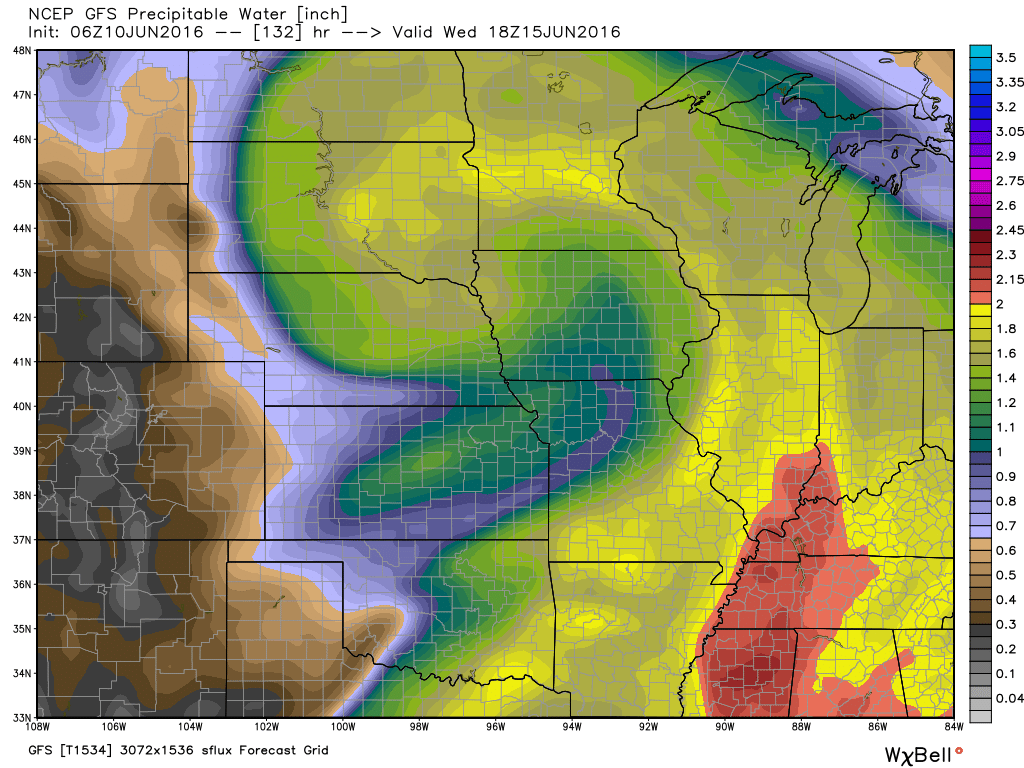
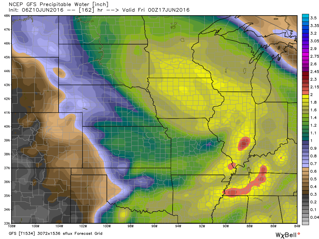
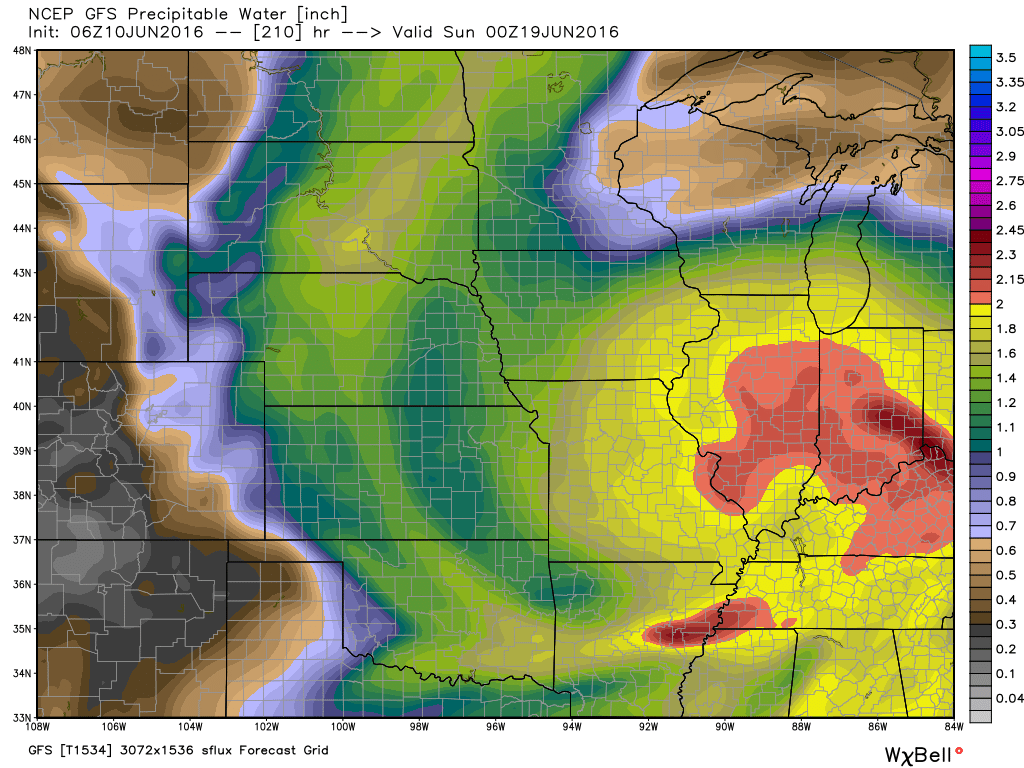
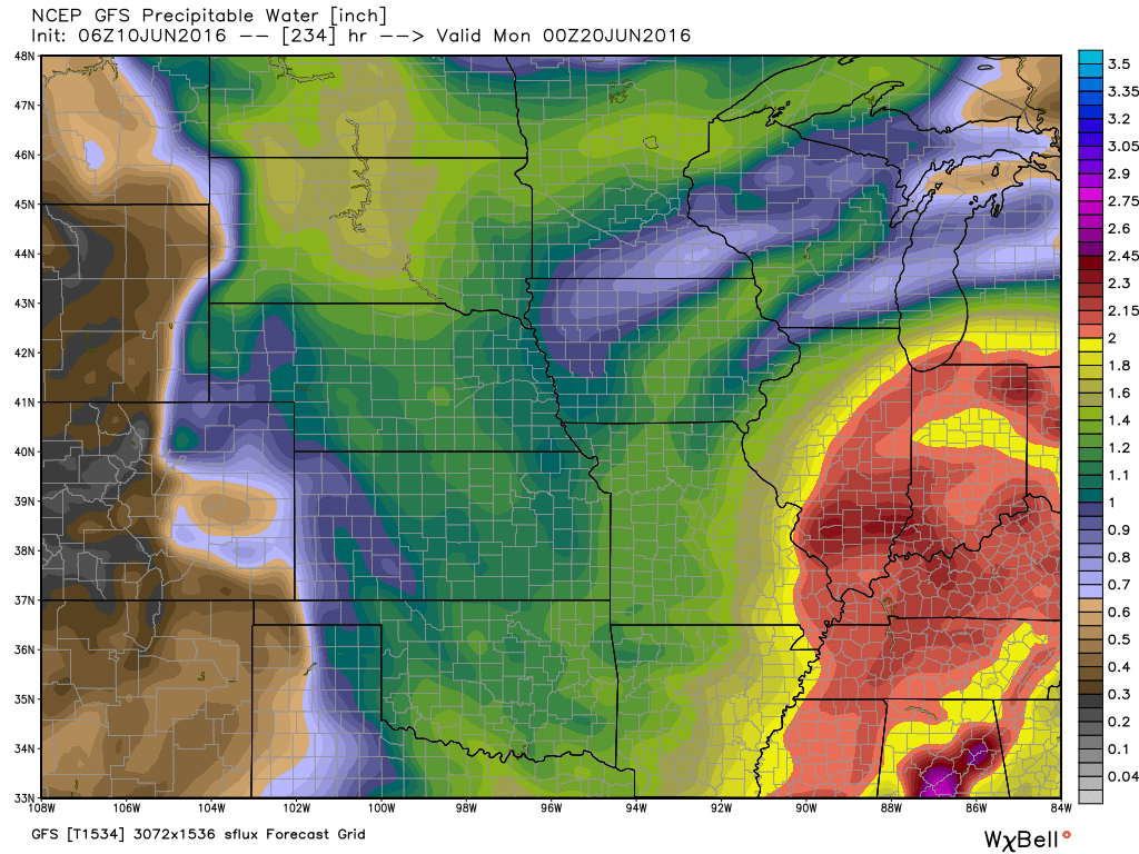
Here are some PWAT value charts for next week. A lot of moisture in the atmosphere. Once you get into the red colors you are looking at PWAT values topping two inches. That is very high.
What are PWAT values? Click here.
This first image is for Monday afternoon. You can see widespread yellow over the region. That would be PWAT values above 1.5″.
This next image is for Tuesday.
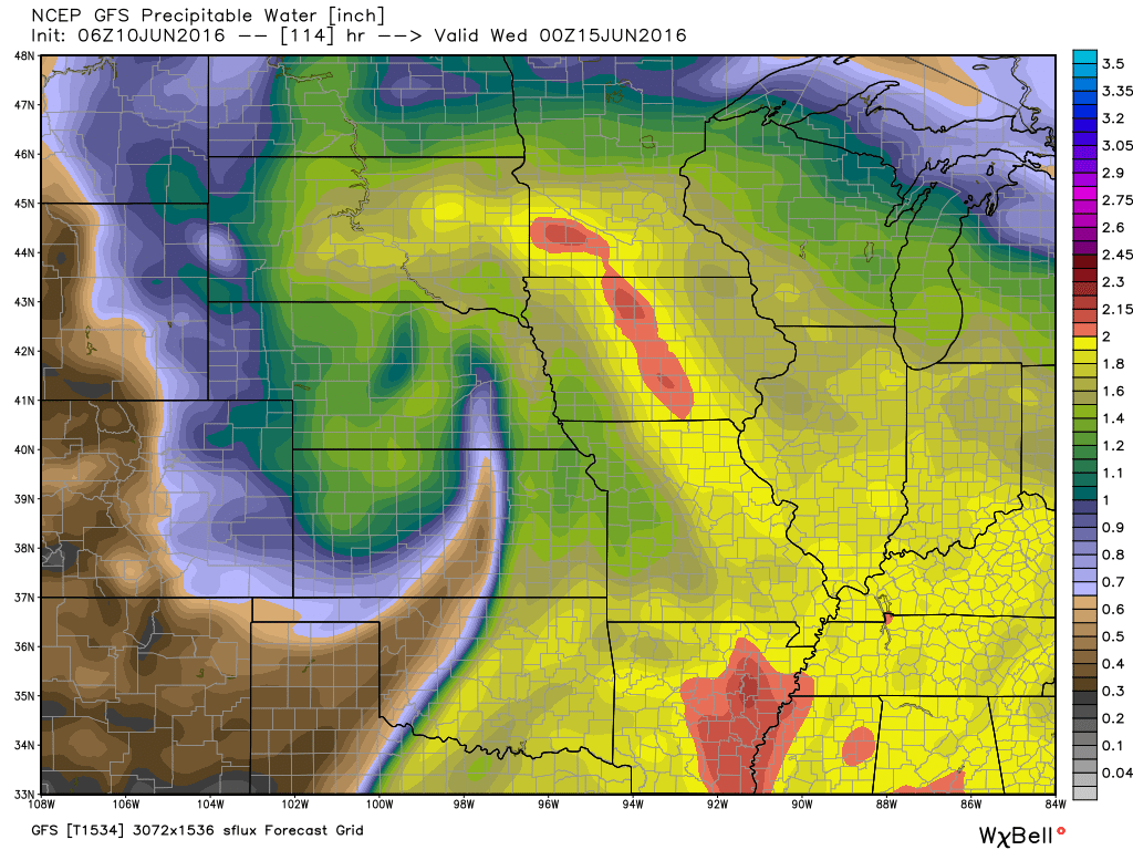
Numbers go up on Wednesday. PWAT values topping two inches.
This next image is for Thursday
This next image is for Saturday. Very high numbers over the Ohio Valley. Some question on how the forecast unfolds next Thursday through Sunday. A slow moving system could deliver additional rain chances.
This last image is for next Sunday. The GFS guidance has very high numbers over our region. Low confidence that this pans out. But, worth monitoring.
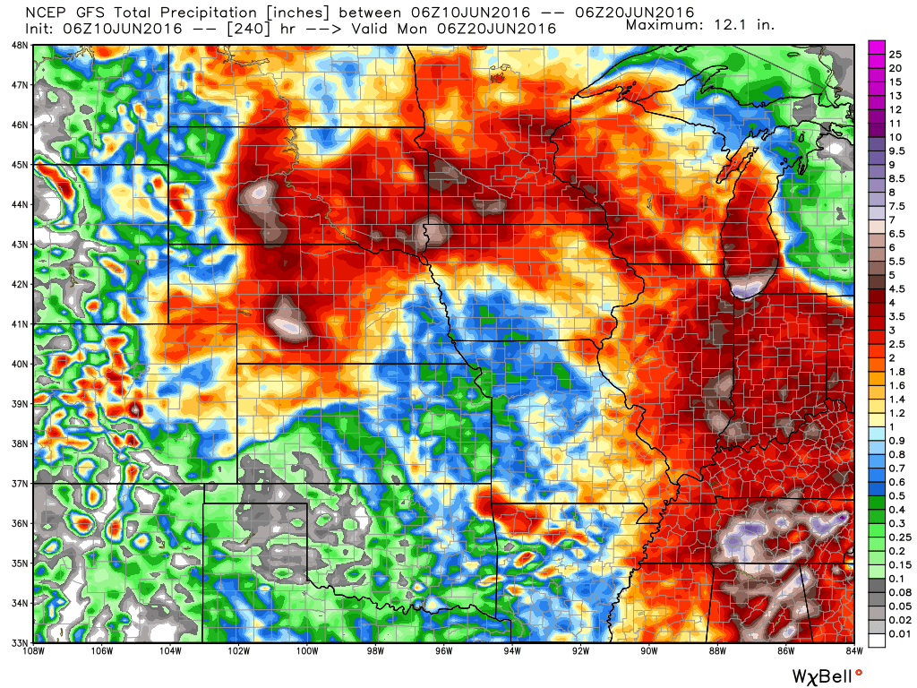
Here is the GFS guidance for rainfall totals. This won’t be exact. But, you get the general idea. We will have showers and thunderstorms next week. Some storms could be heavy. A widespread 0.50″-1.00″ rain event is likely occur from Monday through next Friday. And, some places could very well top two or three inches of rain.
For now, let’s enjoy the weekend. We can worry about rain next week.
Radar


We have regional radars and local city radars – if a radar does not seem to be updating then try another one. Occasional browsers need their cache cleared. You may also try restarting your browser. That usually fixes the problem. Occasionally we do have a radar go down. That is why I have duplicates. Thus, if one fails then try another one.
If you have any problems then please send me an email beaudodson@usawx.com
WEATHER RADAR PAGE – Click here —
We also have a new national interactive radar – you can view that radar by clicking here.
Local interactive city radars include St Louis, Mt Vernon, Evansville, Poplar Bluff, Cape Girardeau, Marion, Paducah, Hopkinsville, Memphis, Nashville, Dyersburg, and all of eastern Kentucky – these are interactive radars. Local city radars – click here

Live Lightning Data – zoom and pan: Click here
Live Lightning Data with sound (click the sound button on the left side of the page): Click here

Can we expect severe thunderstorms over the next 24 to 48 hours? Remember that a severe thunderstorm is defined as a thunderstorm that produces 58 mph winds or higher, quarter size hail or larger, and/or a tornado.
.
Friday night: Severe weather is not anticipated.
Friday night into Saturday night: Severe weather is not anticipated.
Sunday into Sunday night: Isolated thunderstorm chance. Severe weather is not anticipated.
Monday into Friday: Thunderstorms will be possible. Monitor updates. A few storms could produce damaging winds.
.

.
I have adjusted rain chances for late next week. Otherwise, no significant changes.
.

.
No major short range weather concerns (other than hot weather this weekend)
.

.
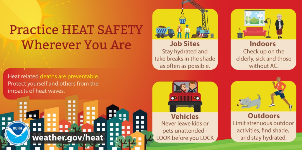
Summer heat will be a concern this weekend. Our first heat wave of the season. Sun screen alert! UV index will range from 9-10 on Friday, Saturday, and Sunday.
.

How much precipitation should we expect over the next few days?

Here are the current river stage forecasts. You can click your state and then the dot for your location. It will bring up the full forecast and hydrograph.
..

Here is the official 6-10 day and 8-14 day temperature and precipitation outlook. Check the date stamp at the top of each image (so you understand the time frame).
The forecast maps below are issued by the Weather Prediction Center (NOAA).


The latest 8-14 day temperature and precipitation outlook. Note the dates are at the top of the image. These maps DO NOT tell you how high or low temperatures or precipitation will be. They simply give you the probability as to whether temperatures or precipitation will be above or below normal.


Who do you trust for your weather information and who holds them accountable?
I have studied weather in our region since the late 1970’s. I have 37 years of experience in observing our regions weather patterns. My degree is in Broadcast Meteorology from Mississippi State University and an Associate of Science (AS). I am currently working on my Bachelor’s Degree in Geoscience.
My resume includes:
Member of the American Meteorological Society.
NOAA Weather-Ready Nation Ambassador.
Meteorologist for McCracken County Emergency Management. I served from 2005 through 2015.
I own and operate the Southern Illinois Weather Observatory.
Recipient of the Mark Trail Award, WPSD Six Who Make A Difference Award, Kentucky Colonel, and the Caesar J. Fiamma” Award from the American Red Cross.
In 2009 I was presented with the Kentucky Office of Highway Safety Award.
Recognized by the Kentucky House of Representatives for my service to the State of Kentucky leading up to several winter storms and severe weather outbreaks.
I am also President of the Shadow Angel Foundation which serves portions of western Kentucky and southern Illinois.
There is a lot of noise on the internet. A lot of weather maps are posted without explanation. Over time you should learn who to trust for your weather information.
My forecast philosophy is simple and straight forward.
- Communicate in simple terms
- To be as accurate as possible within a reasonable time frame before an event
- Interact with you on Twitter, Facebook, and the blog
- Minimize the “hype” that you might see on television or through other weather sources
- Push you towards utilizing wall-to-wall LOCAL TV coverage during severe weather events
I am a recipient of the Mark Trail Award, WPSD Six Who Make A Difference Award, Kentucky Colonel, and the Caesar J. Fiamma” Award from the American Red Cross. In 2009 I was presented with the Kentucky Office of Highway Safety Award. I was recognized by the Kentucky House of Representatives for my service to the State of Kentucky leading up to several winter storms and severe weather outbreaks.
If you click on the image below you can read the Kentucky House of Representatives Resolution.

Many of my graphics are from www.weatherbell.com – a great resource for weather data, model data, and more


You can sign up for my AWARE email by clicking here I typically send out AWARE emails before severe weather, winter storms, or other active weather situations. I do not email watches or warnings. The emails are a basic “heads up” concerning incoming weather conditions.