Thursday, July 6, 2017
I will post your favorite storm tracking links below in the comment section.
Concerns: Locally heavy rain today. Locally intense storms on Friday afternoon and evening. Cloud to ground lightning (typical for the summer months).
Wind forecast for boaters
Remember, thunderstorms can produce much higher wind gusts and are not included in the wind forecast.
Today: South and southwest at 5 to 10 mph with gusts to 15
Tonight: Mostly west at 4 to 8 mph
Friday: South and southwest at 10 to 20 mph. Gusty.
Friday night: Becoming northwest at 7 to 14 mph early in the evening and then northwest at 4 to 8 mph late.
Saturday: North winds at 6 to 12 mph
Sunday: Variable winds at 5 to 10 mph
Just a reminder, I have hired four meteorologists to help with videos each day. On a typical day there will be between two and four videos. In particular, the long range videos are the main reason I brought on some help. These are some of the best long range meteorologists in the central and eastern United States. You can find the videos by clicking on the video tab on your Weather Talk home page.
Forecast details:
Today:
An upper level disturbance continues to slowly move through our region. This disturbance has been responsible for showers and thunderstorms over the last few days.
The system will progress southward and eastward through today. This will help shift the focus of thunderstorms further and further south and east (as we move through the day).
Some of the storms today could produce rainfall totals of one to two inches per hour. This could cause ponding of water on roadways. Same as recent days.
There will once again be a LARGE difference in rainfall totals across the area. This is typical for our summer months. Rainfall totals of 0.00″ to 2.50″ are possible. Locally higher amounts are possible.
Thunderstorm chances will dwindle to below 20% later tonight. We will remain in a warm and muggy air-mass.
Friday into Friday night:
A cold front will move into our region from the north. This front will sag into the region and bump into the very warm and unstable air-mass.
Scattered thunderstorms are forecast to form along the front, especially during the afternoon and evening hours.
A few severe thunderstorms can’t be ruled out. The greatest risk zone will be across southern Illinois and northwest Kentucky. This is where the atmosphere will be the most unstable.
The main concern will be quarter size hail and 60+ mph wind gusts. The tornado risk is low.
Intense storms could, however, occur anywhere in the region on Friday afternoon and evening. I will use the texting service to send out alerts, if need be.
Saturday and Sunday:
BEAUTIFUL weather is anticipated for most of Saturday and Sunday. The one fly in the ointment could be early Saturday morning (before 8 am). This will depend on just how fast our cold front exits. I will include a slight chance of storms early Saturday morning, but believe most of the region will have dried out by then.
The GREAT news is that lower dew points are forecast for the weekend.
The dew point is what controls the feel of the air. Dew points in the upper 60’s to middle 70’s are muggy. Dew points in the 50’s feel great.
Our dew points will drop into the upper 50’s to middle 60’s on Saturday and Sunday. This will feel much nicer than recent days. It will remain warm. Highs in the middle 80’s to near 90 degrees both days.
Sun screen weather with quite a bit of sunshine.
It should be nice camping weather for both Saturday and Sunday (with the one exception being the above mentioned issues for early Saturday morning). I am hoping that most of the storms end on Friday evening/night. Odds favor that happening.
Monday and next week
All good things must come to an end! We will enjoy Saturday and Sunday, but dew points will begin to rise by Monday. A return to muggy air is anticipated. It is summer, after all!
With the return of higher dew points will come shower and thunderstorm chances.
MCS’s are possible next week in the region, but details are still a bit uncertain. What is an MCS? I will post a link in the comment section below.
Basically, they are thunderstorm masses that drop locally heavy rain and can occasionally produce severe weather. MCS’s are responsible for most of the corn belts summer rainfall totals. A necessary evil, as some might say.
Links can be found below.
What is an MCS?
https://weather.com/science/weather-explainers/news/mcs-thunderstorm-clusters-flash-flooding-high-winds-derecho
Storm Tracking Links
Interaction national radar
http://weather.weatherobservatory.com/interactive/
Your local city view interactive radars
http://www.weatherobservatory.com/weather-radar.htm
Your Paducah City Interactive City View Radar
http://www.weatherobservatory.com/radar_paducah.htm
Your Poplar Bluff Interactive City View Radar
http://weatherobservatory.com/radar_pbluff.htm
Your Mt Vernon Interactive City View Radar
http://weatherobservatory.com/radar_mtver.htm
Northeast Arkansas and Missouri Bootheel City View Interactive Radar
http://weatherobservatory.com/radar_memphis.htm
Bootheel Interactive City View Radar
http://weatherobservatory.com/radar_dyers.htm
Purchase Area Interactive Radar
http://weatherobservatory.com/radar_hoptown.htm
Northwest Kentucky and Southeast Illinois City View Interactive Radar
http://weatherobservatory.com/radar_evans.htm
Visible satellite (only to be used during the day)
http://weather.weatherobservatory.com/maps/sats/vis/latest/uslowerohvalley.html
Here is the live lightning tracker. You can see each bolt and adjust your viewing area. Lightning tracking website
https://www.lightningmaps.org/?lang=en#m=sat;r=0;t=3;s=0;o=0;b=;n=0;y=37.4677;x=-88.6755;z=8;d=2;dl=2;dc=0;


Videos can be viewed at this link. Long Range Video Update
If you believe you missed a video then you can also click the LIVE FEED link on the Weather Talk website. That page holds links for several days.
I can text you the videos, as well. Make sure you have text option FOUR turned on. That would be the Weather Extra text option. Sign up for the text messages at www.beaudodsonweather.com
.
 .
..
This forecast update covers southern Illinois, southeast Missouri, western Kentucky. and northwest Tennessee.
.
The following link is for Weather Text subscribers. This is the page where short and long range video outlooks have been posted. The videos are being produced by a team of meteorologists. Some of the best in the region.
https://weathertalk.com/app/beaucast
.
July 5, 2017
Wednesday Night Forecast Details:
Forecast: Cloudy. Warm. A shower or thunderstorm possible, especially eastern half of the region.
Temperatures: MO ~ 68 to 74 IL ~ 68 to 74 KY ~ 70 to 75 TN ~ 70 to 75
Winds: South and southeast at 4 to 8 mph
What impacts are anticipated from the weather? Lightning. Wet roadways. Gusty winds with storms.
My confidence in the forecast verifying: Medium. Some adjustments are possible
Is severe weather expected? Some storms could be quite intense. I can’t rule out a severe thunderstorm.
The NWS defines severe weather as 58 mph winds or great, 1″ hail or larger, and/or tornadoes
What is the chance of precipitation? MO ~ 60% IL ~ 60% KY ~ 60% TN ~ 60%
Coverage of precipitation: Scattered to perhaps numerous.
Should I cancel my outdoor plans? No, but monitor updates and radars.
.
July 6, 2017
Thursday Forecast Details
Forecast: Quite a few clouds. A chance for showers and thunderstorms. Storms ending west to east.
Temperatures: MO ~ 82 to 86 IL ~ 82 to 86 KY ~ 82 to 86 TN ~ 82 to 86
Winds: Southerly winds becoming more north and northwest at 5 to 10 mph
What impacts are anticipated from the weather? Wet roadways. Lightning.
My confidence in the forecast verifying: Medium. Some adjustments are possible.
Is severe weather expected? Monitor updates.
The NWS defines severe weather as 58 mph winds or great, 1″ hail or larger, and/or tornadoes
What is the chance of precipitation? MO ~ 40% IL ~ 50% KY ~ 60% TN ~ 60%
Coverage of precipitation: Scattered to perhaps numerous
Should I cancel my outdoor plans? No, but check radars
.
Thursday Night Forecast Details:
Forecast: Mostly clear to partly cloudy.
Temperatures: MO ~ 66 to 72 IL ~ 66 to 72 KY ~ 66 to 72 TN ~ 66 to 72
Winds: Variable at 3 to 6 mph
What impacts are anticipated from the weather? Most likely none. Perhaps patchy fog. Early evening wet roadways and lightning possible over the Pennyrile area of western Kentucky.
My confidence in the forecast verifying: Medium. Some adjustments are possible
Is severe weather expected? No.
The NWS defines severe weather as 58 mph winds or great, 1″ hail or larger, and/or tornadoes
What is the chance of precipitation? MO ~ 10% IL ~ 10% KY ~ 20% TN ~ 20%
Coverage of precipitation: None to isolated
Should I cancel my outdoor plans? No
.
July 7, 2017
Friday Forecast Details
Forecast: Partly to mostly sunny. Hot and humid. A few thunderstorms possible. Breezy, at times.
Temperatures: MO ~ 88 to 92 IL ~ 88 to 92 KY ~ 88 to 92 TN ~ 88 to 92
Winds: West and southwest winds at 10 to 20 mph. Gusty.
What impacts are anticipated from the weather? Lightning. Wet roadways
My confidence in the forecast verifying: Medium. This forecast should verify.
Is severe weather expected? Monitor updates
The NWS defines severe weather as 58 mph winds or great, 1″ hail or larger, and/or tornadoes
What is the chance of precipitation? MO ~ 30% IL ~ 30% KY ~ 30% TN ~ 30%
Coverage of precipitation: Scattered
Should I cancel my outdoor plans? No, but monitor updates and radars.
.
Friday Night Forecast Details:
Forecast: Partly cloudy. Warm. A chance for an isolated evening storm.
Temperatures: MO ~ 66 to 72 IL ~ 66 to 72 KY ~ 66 to 72 TN ~ 66 to 72
Winds: Winds becoming north and northwest at 5 to 10 mph with gusts to 18 mph
What impacts are anticipated from the weather? Lightning. Wet roadways
My confidence in the forecast verifying: Low. Significant adjustments are possible.
Is severe weather expected? Monitor updates.
The NWS defines severe weather as 58 mph winds or great, 1″ hail or larger, and/or tornadoes
What is the chance of precipitation? MO ~ 30% IL ~ 30% KY ~ 30% TN ~ 30%
Coverage of precipitation: Scattered.
Should I cancel my outdoor plans? No, but monitor updates and radars.
.
July 8, 2017
Saturday Forecast Details
Forecast: Mostly sunny. Patchy cumulus clouds. Less humid. Warm.
Temperatures: MO ~ 85 to 90 IL ~ 85 to 90 KY ~ 85 to 90 TN ~ 85 to 90
Winds: North winds at 5 to 10 mph with gusts to 15 mph.
What impacts are anticipated from the weather? None anticipated
My confidence in the forecast verifying: High. This forecast should verify.
Is severe weather expected? No
The NWS defines severe weather as 58 mph winds or great, 1″ hail or larger, and/or tornadoes
What is the chance of precipitation? MO ~ 0% IL ~ 0% KY ~ 0% TN ~ 0%
Coverage of precipitation: None anticipated
Should I cancel my outdoor plans? No
.
Saturday Night Forecast Details:
Forecast: Mostly clear. Pleasant evening anticipated. Less humid.
Temperatures: MO ~ 62 to 66 IL ~ 62 to 66 KY ~ 62 to 66 TN ~ 65 to 70
Winds: North light winds
What impacts are anticipated from the weather? None anticipated
My confidence in the forecast verifying: High. This forecast should verify.
Is severe weather expected? No
The NWS defines severe weather as 58 mph winds or great, 1″ hail or larger, and/or tornadoes
What is the chance of precipitation? MO ~ 0% IL ~ 0% KY ~ 0% TN ~ 0%
Coverage of precipitation: None anticipated
Should I cancel my outdoor plans? No
.
July 9, 2017
Sunday Forecast Details
Forecast: Partly to mostly sunny. A small chance for a shower.
Temperatures: MO ~ 85 to 90 IL ~ 85 to 90 KY ~ 85 to 90 TN ~ 85 to 90
Winds: Variable winds at 5 to 10 mph.
What impacts are anticipated from the weather? Most likely none
My confidence in the forecast verifying: Low. Significant adjustments are possible.
Is severe weather expected? No
The NWS defines severe weather as 58 mph winds or great, 1″ hail or larger, and/or tornadoes
What is the chance of precipitation? MO ~ 10% IL ~ 10% KY ~ 10% TN ~ 10%
Coverage of precipitation: Most likely none.
Should I cancel my outdoor plans? No
Sunday Night Forecast Details:
Forecast: Mostly clear. A small chance for an evening shower.
Temperatures: MO ~ 65 to 70 IL ~ 65 to 70 KY ~ 65 to 70 TN ~ 65 to 70
Winds: Variable light winds
What impacts are anticipated from the weather? Most likely none.
My confidence in the forecast verifying: Medium. Some adjustments are possible.
Is severe weather expected? No
The NWS defines severe weather as 58 mph winds or great, 1″ hail or larger, and/or tornadoes
What is the chance of precipitation? MO ~ 30% IL ~ 30% KY ~ 30% TN ~ 30%
Coverage of precipitation: None to isolated.
Should I cancel my outdoor plans? No
.
July 10, 2017
Monday Forecast Details
Forecast: Mostly to partly sunny. Some cumulus clouds. Isolated thunderstorm possible. Warm.
Temperatures: MO ~ 85 to 90 IL ~ 85 to 90 KY ~ 85 to 90 TN ~ 85 to 90
Winds: South winds at 5 to 10 mph.
What impacts are anticipated from the weather? Lightning. Wet roadways
My confidence in the forecast verifying: Medium. Some adjustments are possible.
Is severe weather expected? No
The NWS defines severe weather as 58 mph winds or great, 1″ hail or larger, and/or tornadoes
What is the chance of precipitation? MO ~ 20% IL ~ 20% KY ~ 20% TN ~ 20%
Coverage of precipitation: None to isolated.
Should I cancel my outdoor plans? No
.
Monday Night Forecast Details:
Forecast: Partly cloudy. Warm. An isolated thunderstorm possible.
Temperatures: MO ~ 65 to 70 IL ~ 65 to 70 KY ~ 65 to 70 TN ~ 65 to 70
Winds: South winds at 3 to 6 mph
What impacts are anticipated from the weather? Isolated wet roadways and isolated lightning.
My confidence in the forecast verifying: Medium. Some adjustments are possible.
Is severe weather expected? No
The NWS defines severe weather as 58 mph winds or great, 1″ hail or larger, and/or tornadoes
What is the chance of precipitation? MO ~ 20% IL ~ 20% KY ~ 20% TN ~ 20%
Coverage of precipitation: None to isolated.
Should I cancel my outdoor plans? No
.

Don’t forget to check out the Southern Illinois Weather Observatory web-site for weather maps, tower cams, scanner feeds, radars, and much more! Click here
.

A severe thunderstorm is defined as a storm that produces quarter size hail or larger, 58 mph winds or greater, and/or a tornado. That is the official National Weather Service definition of a severe thunderstorm.
Wednesday night into Thursday evening: Isolated reports of high winds possible with storms on Wednesday and Wednesday night. Cloud to ground lightning is a concern for outdoor events. Torrential/tropical downpours could produce over two inch per hour rainfall reports. This is enough to cause localized flash flooding. Widespread severe weather and/or widespread flash flooding is not anticipated.
Friday into Sunday: Severe weather is not anticipated.

I hope everyone had a nice holiday. I did! The weather delivered a mixed bag. Plenty of scattered showers and heavy storms to cause headaches.
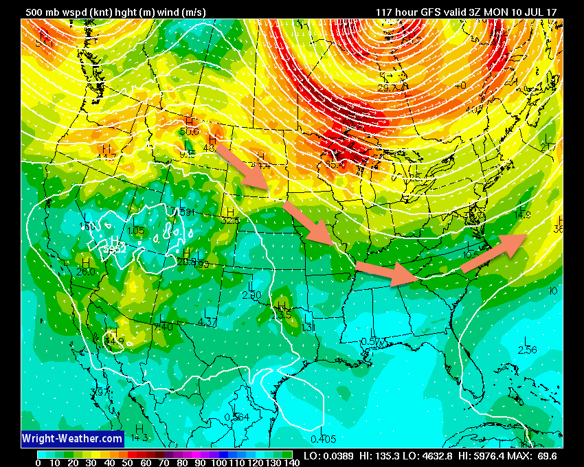
Our weather pattern will slowly evolve over the next few days into more of a northwest flow. What does that mean? Northwest flow is when the jet stream takes a dive into our region from the northwest. This will mean somewhat cooler temperatures, but especially lower dew points. Lower dew points will mean that it will feel nice again when you head outdoors.
Here is the 500 mb wind map for later this weekend. Notice how the winds dive in from the northwest? Northwest flow.
We first have to get through the next 48 to 72 hours hours.
An area of low pressure will slowly track through our region on Wednesday night and Thursday. This low is what has triggered our showers and thunderstorms over the past 12 to 24 hours. It is not in a hurry to exit.
Shower and thunderstorm chances will be with us into Thursday afternoon and evening, but the focus will shift more and more east with time. That means greater chances over the Pennyrile area of western Kentucky as we move into Thursday afternoon vs southeast Missouri.
There is a small risk for severe thunderstorms. Wind fields are fairly weak. That means the threat for organized severe weather is low, but a few reports of damaging winds can’t be ruled out.
Torrential/tropical downpours will be a concern for isolated flash flooding. Storms, this time of the year, can easily drop an inch or two of rain in thirty to sixty minutes. That could flood some of the common problem areas (roads/ditches).
A cold front will move into the region on Friday. This is great news for the weekend. Temperatures and dew points, behind the cold front, will drop a bit. That will mean a fresher atmosphere for Saturday and Sunday.
Thunderstorms are possible along the front on Friday. The threat for severe weather appears low, but a few gusty storms can’t be ruled out.
Let’s check out a few maps
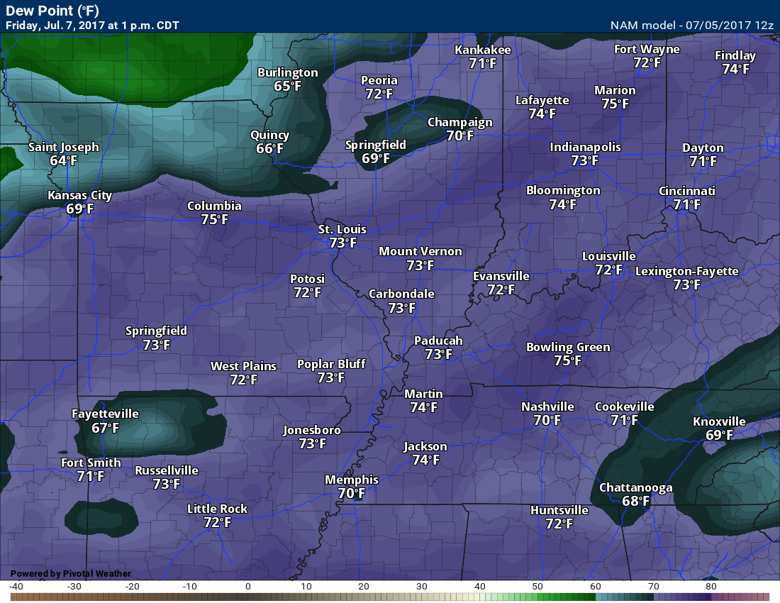
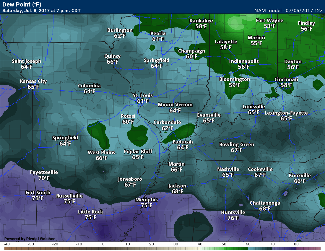
Here is the dew point map for Friday, Saturday, and Sunday
Friday
Click the images to enlarge
Saturday. Better!
Sunday
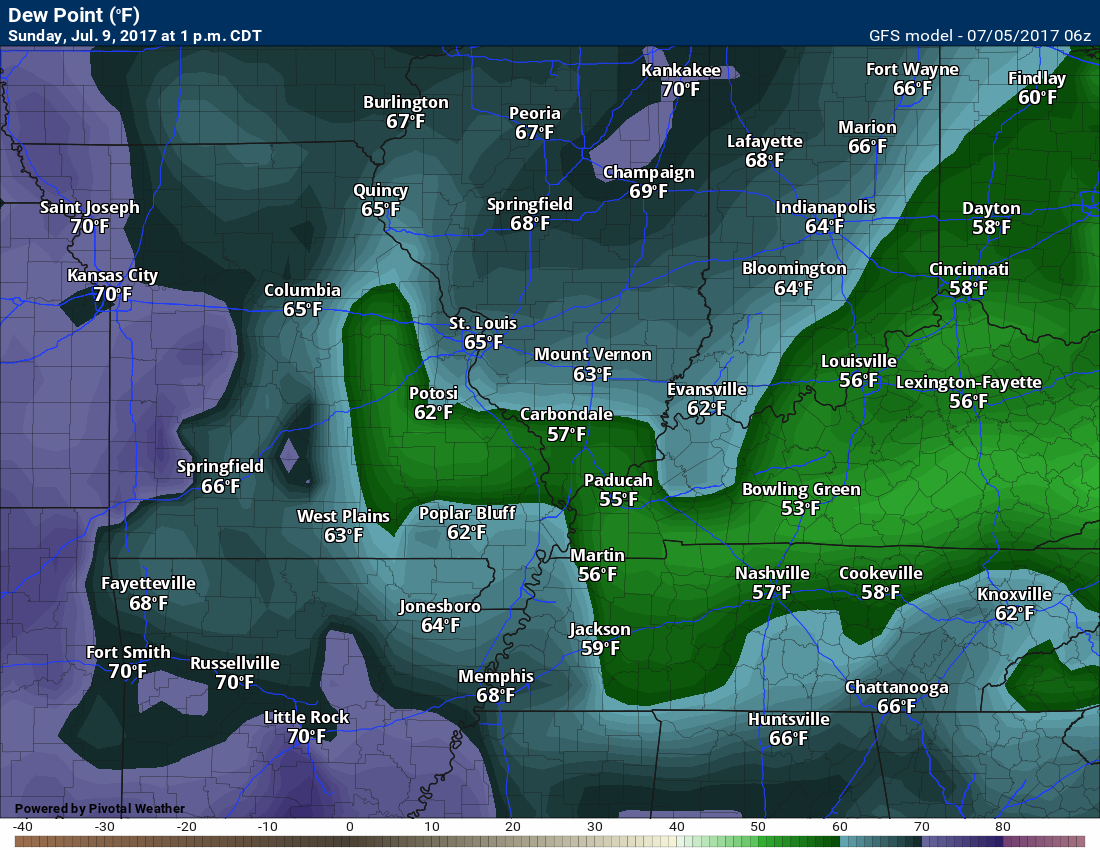
Notice the difference? Dew points in the 70’s are muggy. Dew points in the upper 50’s to lower 60’s is nice (for summer).
Saturday and Sunday should be dry. The European model guidance wants to bring a few showers into the region on Sunday. I will keep an eye on trends.
High temperatures on Friday should range from the upper 80’s into the lower 90’s. Highs on Saturday will likely range from 84 to 88 degrees. Highs on Sunday will likely range from 85 to 90 degrees. Again, the good news isn’t the temperatures, but rather the lower dew points/humidity levels.
Are you subscribing to the Weather Talk texts and videos?
We now have premiere videos for the short and long range forecasts!
Sign up at www.beaudodsonweather.com
We also have an Apple and Android app (scroll down to bottom of the page for more information)

Were you aware that I have hired some help for long range videos? Short range videos, as well. An amazing team of meteorologists.
Click the link below to read more
http://cms.weathertalk.com/meet-the-team/
Weather Talk subscribers now have some of the best short and long range weather videos produced across the eastern United States.
.

Find me on Twitter
.

We have regional radars and local city radars – if a radar does not update then try another one. Occasional browsers need their cache cleared. You may also try restarting your browser. That usually fixes the problem. Occasionally we do have a radar go down. That is why I have duplicates. Thus, if one fails then try another one.
During the winter you can track snow and ice by clicking the winterize button on the local city view interactive radars.
If you have any problems then please send me an email beaudodson@usawx.com
Interactive Weather Radar Page. Choose the city nearest your location: Click this link—
National interactive radar: Click this link.
Local interactive city radars include St Louis, Mt Vernon, Evansville, Poplar Bluff, Cape Girardeau, Marion, Paducah, Hopkinsville, Memphis, Nashville, Dyersburg, and all of eastern Kentucky. These are interactive radars. Local city radars – click here
.

The official 6-10 day and 8-14 day temperature and precipitation outlook. Check the date stamp at the top of each image (so you understand the time frame).
.
The forecast maps below are issued by the Weather Prediction Center (NOAA)
.

.

.
The latest 8-14 day temperature and precipitation outlook. Note the dates are at the top of the image. These maps DO NOT tell you how high or low temperatures or precipitation will be. They simply give you the probability as to whether temperatures or precipitation will be above or below normal.
.


.
The Beau Dodson Weather APP is ready for Apple and Android users. The purpose of this app is for me to deliver your text messages instantly. ATT and Verizon have not always been reliable when it comes to speed. The app allows instant delivery.
Some of you have asked if you can keep receiving the texts on your phone and the app. The answer to that is, yes. The Android app will automatically allow that to happen. On the Apple app, however, you will need to go into your app and click settings. Make sure the green tab is OFF. Off means you will still receive the texts to your phone and the app. If you have any questions, then email me at beaudodson@usawx.com
The app is for text subscribers.
The direct download, for the Apple app, can be viewed here
https://itunes.apple.com/us/app/id1190136514
If you have not signed up for the texting service then you may do so at www.beaudodsonweather.com

The Android app is also ready.
Remember, the app’s are for www.weathertalk.com subscribers. The app allows your to receive the text messages faster than ATT and Verizon.
Here is the download link for the Android version Click Here

——————————————————–
If you have not signed up for the texts messages, then please do. Link www.beaudodsonweather.com
Your support helps with the following:

and


Who do you trust for your weather information and who holds them accountable?
I have studied weather in our region since the late 1970’s. I have 39 years of experience in observing our regions weather patterns. My degree is in Broadcast Meteorology and a Bachelor’s of Science.
My resume includes:
Member of the American Meteorological Society.
NOAA Weather-Ready Nation Ambassador.
Meteorologist for McCracken County Emergency Management. I served from 2005 through 2015.
Meteorologist for McCracken County Rescue. 2015 through current
I own and operate the Southern Illinois Weather Observatory.
I am the chief meteorologist for Weather Talk LLC. I am the owner of Weather Talk LLC.
I am also a business owner in western Kentucky.
Recipient of the Mark Trail Award, WPSD Six Who Make A Difference Award, Kentucky Colonel, and the Caesar J. Fiamma” Award from the American Red Cross.
In 2005 I helped open the largest American Cross shelter in U.S. history in Houston, Texas. I was deployed to help after Hurricane Katrina and Hurricane Rita. I was a shelter manager of one of the Houston, Texas shelter divisions.
In 2009 I was presented with the Kentucky Office of Highway Safety Award.
Recognized by the Kentucky House of Representatives for my service to the State of Kentucky leading up to several winter storms and severe weather outbreaks.
If you click on the image below you can read the Kentucky House of Representatives Resolution.

I am also President of the Shadow Angel Foundation which serves portions of western Kentucky and southern Illinois.
There is a lot of noise on the internet. A lot of weather maps are posted without explanation. Over time you should learn who to trust for your weather information.
My forecast philosophy is simple and straight forward.
- Communicate in simple terms
- To be as accurate as possible within a reasonable time frame before an event
- Interact with you on Twitter, Facebook, email, texts, and this blog
- Minimize the “hype” that you might see on some television stations or through other weather sources
- Push you towards utilizing wall-to-wall LOCAL TV coverage during severe weather events
Many of the graphics on this page are from www.weatherbell.com
WeatherBell is a great resource for weather model guidance.


You can sign up for my AWARE email by clicking here I typically send out AWARE emails before severe weather, winter storms, or other active weather situations. I do not email watches or warnings. The emails are a basic “heads up” concerning incoming weather conditions