
We offer interactive local city live radars and regional radars. If a radar does not update then try another one. If a radar does not appear to be refreshing then hit Ctrl F5. You may also try restarting your browser.

July 29, 2018
Sunday Forecast Details
Forecast:
A mix of sun and clouds. Increasing clouds through the day. Scattered showers possible over mainly southeast Missouri and southern Illinois. Not as warm (mainly because of some clouds). We will need to monitor the precipitation coverage.
Temperatures: MO ~ 80 to 85 IL ~ 78 to 85 KY ~ 84 to 86 TN ~ 84 to 86
What is the chance of precipitation? MO ~ 50% to 60% IL ~ 40% to 50% KY ~ 30% TN ~ 20% to 30%
Coverage of precipitation: Scattered
Wind: Becoming east and southeast at 5 to 10 mph
What impacts are anticipated from the weather? Wet roadways and lightning. A few storms could produce gusty winds.
My confidence in the forecast verifying: Medium
Is severe weather expected? For most of the region, no. There will be a risk over southeast Missouri for a strong storm or two with gusty wind.
The NWS defines severe weather as 58 mph wind or great, 1″ hail or larger, and/or tornadoes
Should I cancel my outdoor plans? No, but monitor radars (esp over southeast Missouri and southern Illinois)
UV Index: 6 to 8 Moderate (depending on your location vs the thicker cloud cover)
Sunrise: 5:56 AM
Sunday Night Forecast Details:
Forecast: Cloudy with scattered showers and thunderstorms. Locally heavy rain where storms occur. Best chances over southeast Missouri and southern Illinois. Decreasing chances as you travel southeast.
Temperatures: MO ~ 64 to 68 IL ~ 64 to 68 KY ~ 64 to 68 TN ~ 66 to 68
What is the chance of precipitation? MO ~ 50% to 60% IL ~ 50% to 60% KY ~ 40% to 50% TN ~ 40% to 50%
Coverage of precipitation: Scattered to perhaps numerous. Greatest coverage over southeast Missouri and southern Illinois
Wind: East and southeast at 5 to 10 mph
What impacts are anticipated from the weather? Wet roadways and lightning. Locally heavy rain where thunderstorms occur.
My confidence in the forecast verifying: Medium
Is severe weather expected? Unlikely, but monitor updates. An isolated strong storm possible.
The NWS defines severe weather as 58 mph wind or great, 1″ hail or larger, and/or tornadoes
Should I cancel my outdoor plans? Rain is possible. Monitor radars
Sunset: 8:04 PM
Moonrise: 9:54 PM Waning Gibbous
Moonset: 8:25 AM
July 30, 2018
Monday Forecast Details
Forecast: Mostly cloudy. Scattered showers and thunderstorms. Locally heavy rain where thunderstorms occur. Temperatures will be dependent on cloud cover. Thicker clouds/precipitation will yield highs in the upper 70’s and lower 80’s.
Temperatures: MO ~ 78 to 84 IL ~ 78 to 84 KY ~ 83 to 86 TN ~ 83 to 86
What is the chance of precipitation? MO ~ 50% to 60% IL ~ 50% to 60% KY ~ 40% to 50% TN ~ 40% to 50%
Coverage of precipitation: Scattered to perhaps numerous
Wind: North and northwest at 5 to 10 mph
What impacts are anticipated from the weather? Wet roadways and lightning. Locally heavy rain where thunderstorms occur.
My confidence in the forecast verifying: Medium
Is severe weather expected? A strong storm is possible, but most likely storms will remain below severe levels.
The NWS defines severe weather as 58 mph wind or great, 1″ hail or larger, and/or tornadoes
Should I cancel my outdoor plans? I would suggest monitoring radars and having a plan B
UV Index: 3 to 6 (clouds will cause the UV index to be lower)
Sunrise: 5:58 AM
Monday Night Forecast Details:
Forecast: Cloudy with showers and thunderstorms. Locally heavy rain possible where thunderstorms occur.
Temperatures: MO ~ 63 to 66 IL ~ 63 to 66 KY ~ 64 to 68 TN ~ 66 to 68
What is the chance of precipitation? MO ~ 40% to 50% IL ~ 50% KY ~ 50% to 60% TN ~ 50% to 60%
Coverage of precipitation: Scattered to perhaps numerous
Wind: Northerly at 4 to 8 mph
What impacts are anticipated from the weather? Wet roadways and lightning. Locally heavy rain where thunderstorms occur.
My confidence in the forecast verifying: Medium
Is severe weather expected? Unlikely, but monitor updates
The NWS defines severe weather as 58 mph wind or great, 1″ hail or larger, and/or tornadoes
Should I cancel my outdoor plans? Monitor updates. Rain is possible. Have a plan B.
Sunset: 8:04 PM
Moonrise: 9:53 PM Waning Gibbous
Moonset: 8:23 AM
July 31, 2018
Tuesday Forecast Details
Forecast: Partly to mostly cloudy. Scattered showers and thunderstorms. High temperatures will again be highly dependent on cloud cover.
Temperatures: MO ~ 78 to 84 IL ~ 76 to 82 KY ~ 78 to 84 TN ~ 82 to 85
What is the chance of precipitation? MO ~ 40% to 50% IL ~ 40% to 50% KY ~ 40% to 50% TN ~ 40% to 50%
Coverage of precipitation: Scattered
Wind: Northwest at 3 to 6 mph
What impacts are anticipated from the weather? Wet roadways and lightning.
My confidence in the forecast verifying: Medium
Is severe weather expected? No
The NWS defines severe weather as 58 mph wind or great, 1″ hail or larger, and/or tornadoes
Should I cancel my outdoor plans? I would monitor radars and updates. Some rain will likely linger into Tuesday
UV Index: 4 to 6 Moderate
Sunrise: 5:59 AM
Tuesday Night Forecast Details:
Forecast: Some evening clouds. A few showers remaining. Patchy fog possible.
Temperatures: MO ~ 63 to 66 IL ~ 63 to 66 KY ~ 63 to 66 TN ~ 63 to 65
What is the chance of precipitation? MO ~10% IL ~ 20% KY ~ 20% TN ~ 10%
Coverage of precipitation: Spotty. Ending.
Wind: North and norhtwest at 5 to 10 mph
What impacts are anticipated from the weather? Evening wet roadways and lightning. Fog possible overnight.
My confidence in the forecast verifying: Medium to high
Is severe weather expected? No
The NWS defines severe weather as 58 mph wind or great, 1″ hail or larger, and/or tornadoes
Should I cancel my outdoor plans? No, but check radars
Sunset: 8:03 PM
Moonrise: 10:25 PM Waning Gibbous
Moonset: 9:21 AM
August 1, 2018
Wednesday Forecast Details
Forecast: Partly cloudy. Mild. Morning fog possible.
Temperatures: MO ~ 83 to 86 IL ~ 82 to 85 KY ~ 82 to 85 TN ~ 82 to 85
What is the chance of precipitation? MO ~ 5% IL ~ 5% KY ~ 10% TN ~ 10%
Coverage of precipitation: Most likely none
Wind: Northwest at 3 to 6 mph
What impacts are anticipated from the weather? If fog develops then there would be lower visibility during the morning hours
My confidence in the forecast verifying: Medium to high
Is severe weather expected? No
The NWS defines severe weather as 58 mph wind or great, 1″ hail or larger, and/or tornadoes
Should I cancel my outdoor plans? No
UV Index: 8 to 10 High
Sunrise: 5:59 AM
Wednesday Night Forecast Details:
Forecast: Mostly clear with a few passing clouds. Patchy fog.
Temperatures: MO ~ 63 to 66 IL ~ 63 to 66 KY ~ 64 to 66 TN ~ 64 to 66
What is the chance of precipitation? MO ~ 0% IL ~ 0% KY ~ 0% TN ~ 0%
Coverage of precipitation: Most likely none
Wind: Variable light wind
What impacts are anticipated from the weather? Lower visibility if fog forms
My confidence in the forecast verifying: High
Is severe weather expected? No
The NWS defines severe weather as 58 mph wind or great, 1″ hail or larger, and/or tornadoes
Should I cancel my outdoor plans? No
Sunset: 8:02 PM
Moonrise: 10:55 PM Waning Gibbous
Moonset: 10:21 AM
August 2, 2018
Thursday Forecast Details
Forecast: Partly to mostly sunny. Warmer. Patchy morning fog possible.
Temperatures: MO ~ 85 to 88 IL ~ 83 to 86 KY ~ 84 to 88 TN ~ 84 to 88
What is the chance of precipitation? MO ~ 0% IL ~ 0% KY ~ 0% TN ~ 0%
Coverage of precipitation: Most likely none
Wind: Variable to southwest at 3 to 6 mph
What impacts are anticipated from the weather? None
My confidence in the forecast verifying: High
Is severe weather expected? No
The NWS defines severe weather as 58 mph wind or great, 1″ hail or larger, and/or tornadoes
Should I cancel my outdoor plans? No
UV Index: 9 to 10 High
Sunrise: 6:00 AM
Thursday Night Forecast Details:
Forecast: Mostly clear with a few passing clouds.
Temperatures: MO ~ 63 to 66 IL ~ 63 to 66 KY ~ 64 to 66 TN ~ 64 to 66
What is the chance of precipitation? MO ~ 0% IL ~ 0% KY ~ 0% TN ~ 0%
Coverage of precipitation: None
Wind: South at 2 to 4 mph
What impacts are anticipated from the weather? None
My confidence in the forecast verifying: High
Is severe weather expected? No
The NWS defines severe weather as 58 mph wind or great, 1″ hail or larger, and/or tornadoes
Should I cancel my outdoor plans? No
Sunset: 8:01 PM
Moonrise: 11:25 PM Waning Gibbous
Moonset: 11:20 AM
Forecast: Partly to mostly sunny. Warm and humid. An isolated thunderstorm possible during the heat of the day. Garden variety if any at all.
Temperatures: MO ~ 84 to 88 IL ~ 84 to 88 KY ~ 84 to 88 TN ~ 84 to 88
What is the chance of precipitation? MO ~ 20% IL ~ 10% KY ~ 10% TN ~ 10%
Coverage of precipitation: None to isolated
Wind: South at 5 mph
What impacts are anticipated from the weather? Isolated wet roads and lightning.
My confidence in the forecast verifying: High
Is severe weather expected? Unlikely
The NWS defines severe weather as 58 mph wind or great, 1″ hail or larger, and/or tornadoes
Should I cancel my outdoor plans? No
UV Index: 9 to 10 High
Sunrise: 6:01 AM
Friday Night Forecast Details:
Forecast: Mostly clear with a few passing clouds. Mild and humid. An isolated thunderstorm possible before 7 PM.
Temperatures: MO ~ 64 to 68 IL ~ 64 to 66 KY ~ 64 to 68 TN ~ 64 to 68
What is the chance of precipitation? MO ~ 10% IL ~ 10% KY ~ 10% TN ~ 10%
Coverage of precipitation: None to isolated
Wind: South at 2 to 4 mph
What impacts are anticipated from the weather? None to isolated wet roads and lightning.
My confidence in the forecast verifying: High
Is severe weather expected? No
The NWS defines severe weather as 58 mph wind or great, 1″ hail or larger, and/or tornadoes
Should I cancel my outdoor plans? No
Sunset: 8:00 PM
Moonrise: 11:57 PM Waning Gibbous
Moonset: 12:17 PM
August 4, 2018
Saturday Forecast Details
Forecast: Partly to mostly sunny. Warm and humid. An isolated heat of the day thunderstorm possible.
Temperatures: MO ~ 85 to 90 IL ~ 85 to 88 KY ~ 86 to 88 TN ~ 86 to 88
What is the chance of precipitation? MO ~ 10% IL ~ 10% KY ~ 10% TN ~ 10%
Coverage of precipitation: None for most. Isolated storm possible.
Wind: South at 5 mph
What impacts are anticipated from the weather? None for most. An isolated wet road and lightning.
My confidence in the forecast verifying: Medium
Is severe weather expected? No
The NWS defines severe weather as 58 mph wind or great, 1″ hail or larger, and/or tornadoes
Should I cancel my outdoor plans? No
UV Index: 9 to 10 High
Sunrise: 6:02 AM
Saturday Night Forecast Details:
Forecast: Mostly clear with a few passing clouds.
Temperatures: MO ~ 65 to 70 IL ~ 65 to 68 KY ~ 64 to 68 TN ~ 64 to 68
What is the chance of precipitation? MO ~ 0% IL ~ 0% KY ~ 0% TN ~ 0%
Coverage of precipitation: None
Wind: South at 2 to 4 mph
What impacts are anticipated from the weather? Most likely none
My confidence in the forecast verifying: Medium
Is severe weather expected? No
The NWS defines severe weather as 58 mph wind or great, 1″ hail or larger, and/or tornadoes
Should I cancel my outdoor plans? No
Sunset: 7:58 PM
Moonrise: 11:59 PM Last quarter
Moonset: 1:19 PM
August 5, 2018
Sunday Forecast Details
Forecast: Partly to mostly sunny. Warm.
Temperatures: MO ~ 86 to 92 IL ~ 86 to 88 KY ~ 86 to 90 TN ~ 86 to 90
What is the chance of precipitation? MO ~ 10% IL ~ 10% KY ~ 10% TN ~ 10%
Coverage of precipitation: Most likely none
Wind: South at 5 to 10 mph
What impacts are anticipated from the weather? None
My confidence in the forecast verifying: Medium
Is severe weather expected? No
The NWS defines severe weather as 58 mph wind or great, 1″ hail or larger, and/or tornadoes
Should I cancel my outdoor plans? No
UV Index: 9 to 10 High
Sunrise: 6:03 AM
Sunday Night Forecast Details:
Forecast: Partly cloudy.
Temperatures: MO ~ 65 to 70 IL ~ 65 to 68 KY ~ 64 to 68 TN ~ 64 to 68
What is the chance of precipitation? MO ~ 10% IL ~ 10% KY ~ 10% TN ~ 10%
Coverage of precipitation: None
Wind: South at 2 to 4 mph
What impacts are anticipated from the weather? Most likely none
My confidence in the forecast verifying: Medium
Is severe weather expected? No
The NWS defines severe weather as 58 mph wind or great, 1″ hail or larger, and/or tornadoes
Should I cancel my outdoor plans? No
Sunset: 7:58 PM
Moonrise: 12:32 AM Waning crescent
Moonset: 2:24 PM
Learn more about the UV index readings. Click here.

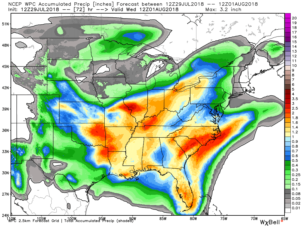
Here is the latest WPC / NOAA Rainfall charts
This graphic will not cover those wild swings in rainfall totals that occur from locally heavy thunderstorms. These number will be greatly underdone where slow moving thunderstorms occur.
Most of this falls Sunday into Tuesday.
There are quite a few model guidance packages that show less rainfall totals across portions of the region. This may be a concern for those in need of rain.
Click to enlarge graphics on this page
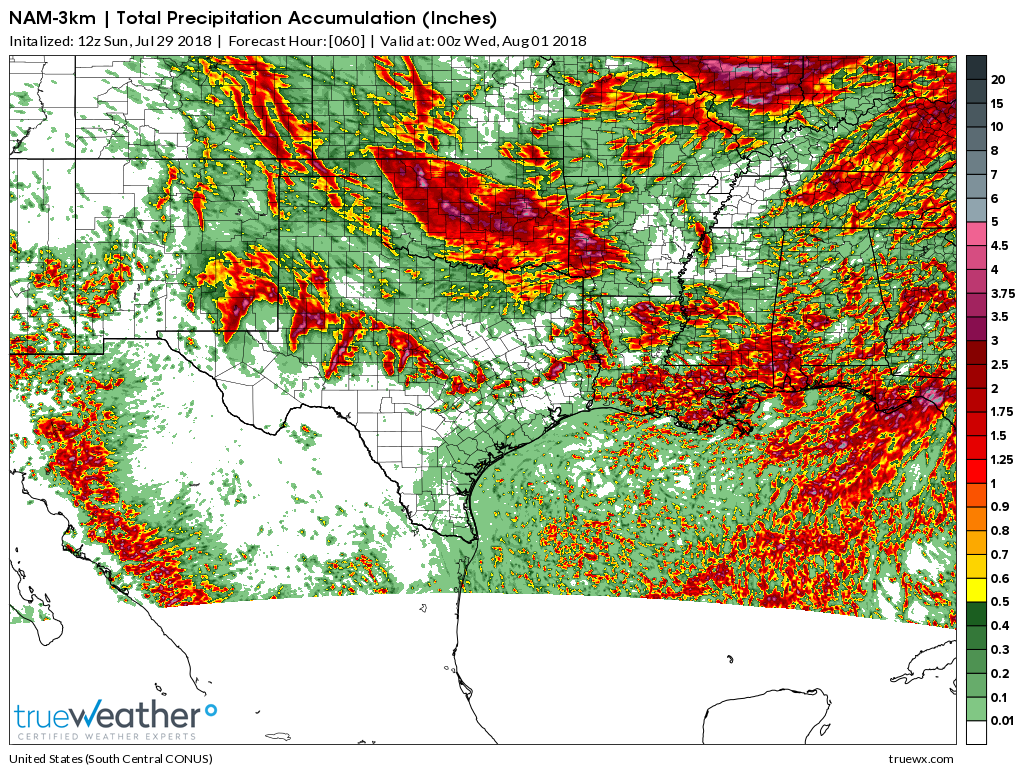
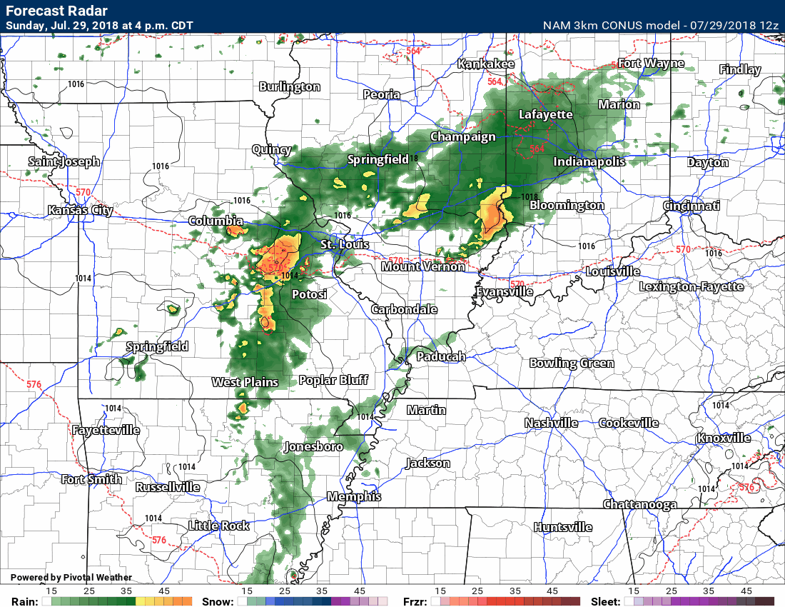
Here is the latest NAM model rainfall forecast
Notice that area where less precipitation occurs? In or near our region. That seems fairly likely to happen. The question is placement.
I know many of you need rain.
The placement of lesser rain totals favors our southern counties.
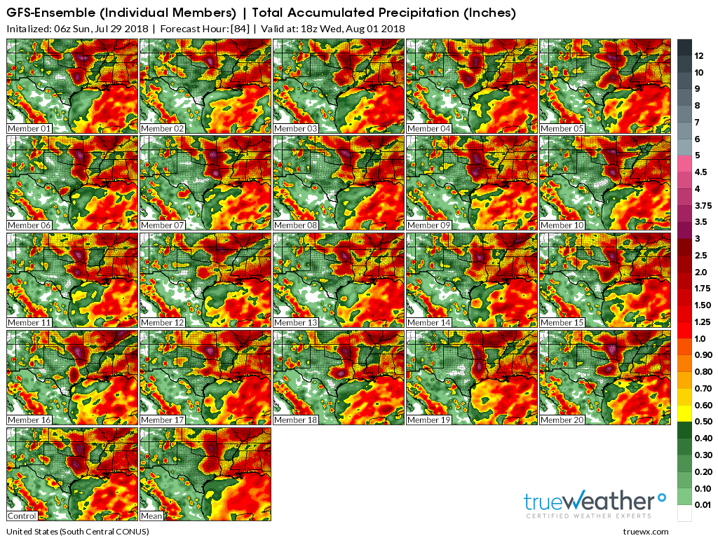
Here are the GFS ensembles
Notice the area of less precipitation? Again, this is a concern for some of us.
Click to enlarge this graphic. It is a bit hard to read. This is the southern United States. Our area is located in the upper right portion of each square graphic.
What are ensembles? I am glad you asked!
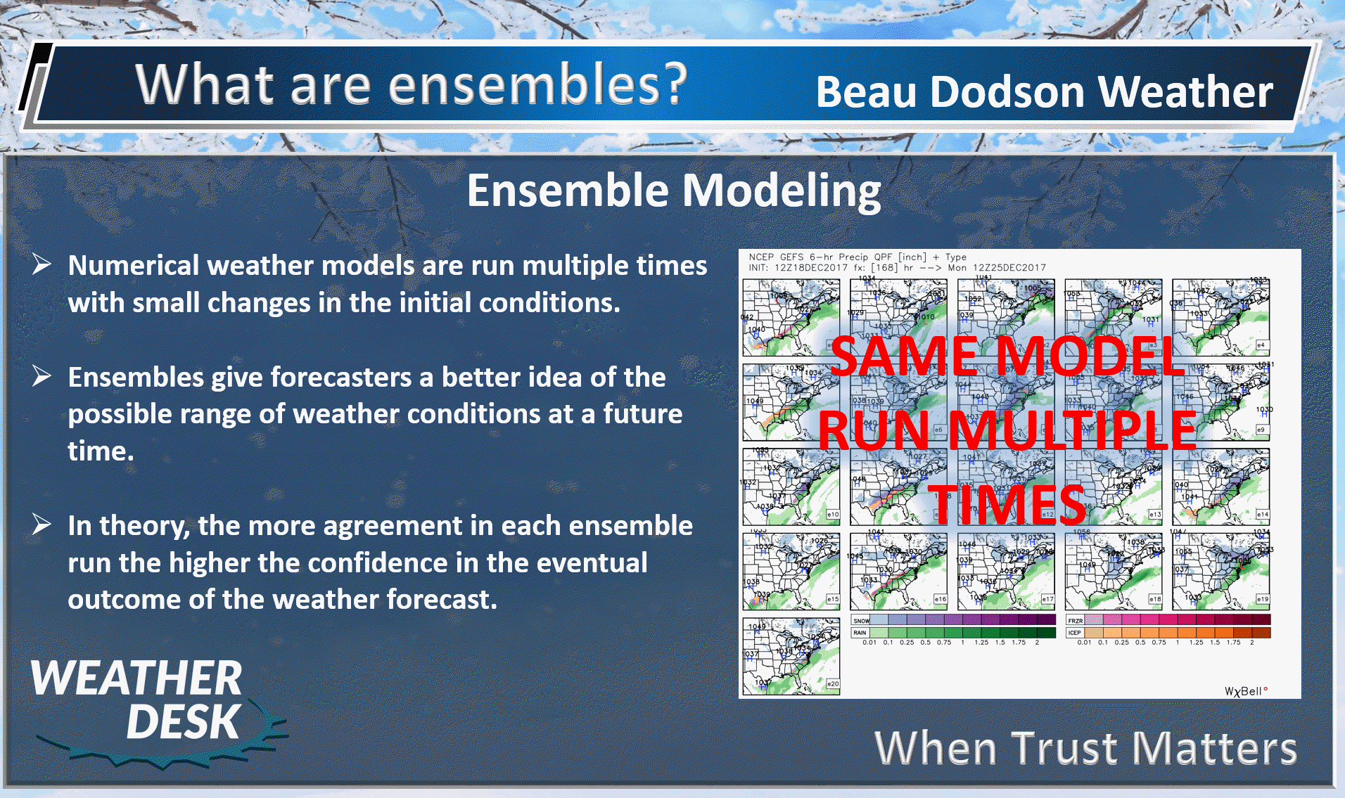
Bottom line, some of you may receive considerably less rainfall than others.
.

We offer interactive local city live radars and regional radars. If a radar does not update then try another one.
If a radar does not appear to be refreshing then hit Ctrl F5 on your keyboard.
You may also try restarting your browser.
The local city view radars also have clickable warnings.
During the winter months, you can track snow and ice by clicking the winterize button on the local city view interactive radars.

Questions? Broken links? Other questions?
You may email me at beaudodson@usawx.com

The National Weather Service defines a severe thunderstorm as one that produces quarter size hail or larger, 58 mph winds or greater, and/or a tornado.
Sunday through Tuesday: Thunderstorms are possible Sunday into Tuesday.
There is a low end risk of strong thunderstorms across southeast Missouri and southern Illinois Sunday into Sunday night. The main concern would be gusty winds.
There is a low end risk of strong thunderstorms across the entire region Monday into Monday night. The main concern would be isolated strong wind gusts.
Locally heavy rain will be a concern with PWAT values of 1.7″ to 2.0″. That is a lot of moisture for storms to tap into. Remember, PWAT is a measure of moisture in the entire atmosphere.
===============================
Summer thunderstorms can produce isolated microbursts.
microburst winds can exceed 50 mph.
What are microbursts?

Interactive live weather radar page. Choose the city nearest your location. If one of the cities does not work then try a nearby one. Click here.
National map of weather watches and warnings. Click here.
Storm Prediction Center. Click here.
Weather Prediction Center. Click here.

Live lightning data: Click here.

Weather Headlines
- Unsettled couple of days
- Some of you may end up with very little in the way of rain totals
- Shower and thunderstorm chances today into Tuesday
- Mostly dry Wednesday into the weekend
- Warm
We will have an unsettled period of weather over the coming 48 to 72 hours.
The main concern will be on and off shower and thunderstorm chances. There will be locally heavy rain where thunderstorms occur.
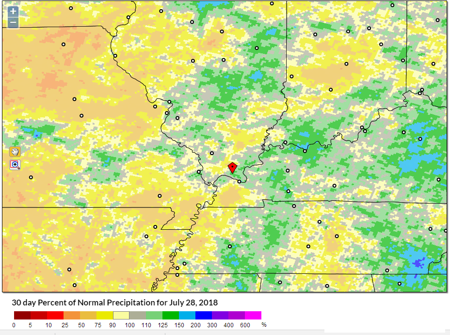
The bulk of the region should pick up 0.40″ to 0.80″ of rain. There will be some locations exceed two inches of rain. That would be where thunderstorms occur. PWAT values are high. Lot of moisture to work with.
We do need rain. Many areas are a bit on the dry side. Thus, this rain will be welcome by many.
Here is the latest SPI index (a measure of moisture). This shows you the last 30 days of precipitation departures.
The overall risk of severe weather is small. I can’t rule out a few reports of strong and gusty winds. The Storm Prediction Center has outlined portions of the region for strong storms today and again on Monday.
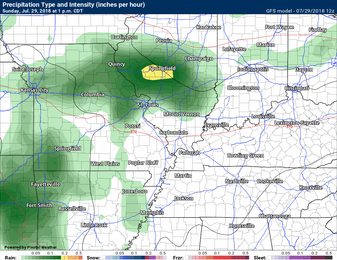
Keep in mind, this is just a model and models are never exact. This just gives you a general idea of the possibilities.
The time stamp is located in the upper left portion of the animation.
This is the NAM model future-cast radar animation.
Here is another model. This is the GFS model.
We should dry out Wednesday into the weekend. Some models are showing isolated showers and thunderstorms. For now, I have left the forecast dry.
It will remain warm into the weekend. We will flirt with the upper 80’s to around 90 degrees Friday into Sunday.
We offer interactive local city live radars and regional radars. If a radar does not update then try another one. If a radar does not appear to be refreshing then hit Ctrl F5. You may also try restarting your browser.
The local city view radars also have clickable warnings.
During the winter months, you can track snow and ice by clicking the winterize button on the local city view interactive radars.
You may email me at beaudodson@usawx.com
Find me on Facebook!

Find me on Twitter!

Did you know that a portion of your monthly subscription helps support local charity projects?
You can learn more about those projects by visiting the Shadow Angel Foundation website and the Beau Dodson News website.

I encourage subscribers to use the app vs regular text messaging. We have found text messaging to be delayed during severe weather. The app typically will receive the messages instantly. I recommend people have three to four methods of receiving their severe weather information.
Remember, my app and text alerts are hand typed and not computer generated. You are being given personal attention during significant weather events.
