What you need to know.
.
Key Points
- A line of thunderstorms (perhaps more than one) will impact at least portions of southeast Missouri and southern Illinois this afternoon into tonight.
- The severe risk is higher over southeast Missouri and southern Illinois. The threat is highest along and north of Bollinger and Cape Girardeau Counties in southeast Missouri and along and north of a line from Jackson, Williamson, Saline, and Gallatin Counties in southern Illinois.
- The threat of severe weather south of that line is less certain. That does not mean you are out of the woods. Monitor updates.
- Locally heavy rain will cause pockets of flash flooding. Again, the risk is higher over Missouri and Illinois. See the future-cast radars below.
- There are concerns that a few thunderstorms could produce wind damage, hail, and tornadoes.
Call to action.
Monitor updated weather forecasts.
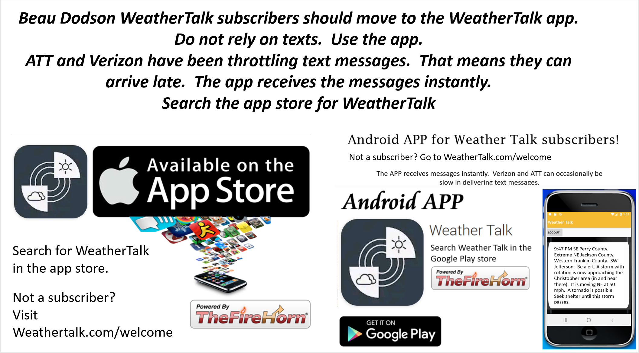
Make sure you are using the Weather Talk app. Download it from the app store. It is under Weather Talk.
TURN ON YOUR BEAU DODSON WEATHER TALK APP. Make sure it is on. Make sure you have not accidentally logged out of the app.
The app is for subscribers (please log into your account and make sure your payment has been updated. We have a large number of declined cards and PayPal payments.
Subscribe at www.weathertalk.com/welcome then go to your app store and search for WeatherTalk. Apple users click here. Android users click here
.
Wednesday, July 15, 2020
10:54
Storms have weakened.
End of severe event,
9:12 PM
July 15, 2020. 9:12 PM
Bollinger, Cape Girardeau, and Scott Counties in Missouri.
Western Union, Alexander, and Pulaski Counties in Illinois.
Radar shows a line of severe thunderstorms northern Bollinger and northern Cape Girardeau Counties in southeast Missouri and clipping southwest Jackson County, Illinois.
This line continues to move S SE at 50 mph.
Damaging wind is possible with this line of thunderstorms. Nickel size hail, as well. Frequent lightning. There is also a low-end chance of short-lived tornadoes.
Be weather aware as these storms push through the area.
Radars and Lightning Data
Interactive city-view radars
http://weatherobservatory.com/weather-radar.htm
A third backup radar
https://weathertalk.com/morani
Clickable watches and warnings can be viewed on the local city-view interactive radars (link above). Be sure and turn on the warnings above the local radars.
A new regional radar we offer
https://imagery.weathertalk.com/prx/RadarLoop.mp4
Lightning data
https://wtalk.co/7QT7WHKU
.
8:53 PM
July 15, 2020. 8:53 PM
Southwest Jackson County and Union County, Illinois.
Update.
Radar shows a line of severe thunderstorms in Perry County, Missouri. This line is moving S SE at 45 mph.
These storms will clip southwest Jackson County, Illinois. They will enter Union County.
Damaging wind is possible with this thunderstorm. Nickel size hail, as well. Frequent lightning. There is also a low-end chance of short-lived tornadoes.
Be weather aware as these storms push through the area.
Radars and Lightning Data
Interactive city-view radars
http://weatherobservatory.com/weather-radar.htm
A third backup radar
https://weathertalk.com/morani
Clickable watches and warnings can be viewed on the local city-view interactive radars (link above). Be sure and turn on the warnings above the local radars.
A new regional radar we offer
https://imagery.weathertalk.com/prx/RadarLoop.mp4
Lightning data
https://wtalk.co/7QT7WHKU
.
8:37 PM
July 15, 2020. 8:35 PM
Jackson, Williamson, and Union Counties.
The thunderstorms that produced the tornado warning have weakened.
These storms may still produce pockets of 55+ mph wind gusts, torrential rain, lightning, and nickel size hail.
Radars and Lightning Data
Interactive city-view radars
http://weatherobservatory.com/weather-radar.htm
A third backup radar
https://weathertalk.com/morani
Clickable watches and warnings can be viewed on the local city-view interactive radars (link above). Be sure and turn on the warnings above the local radars.
A new regional radar we offer
https://imagery.weathertalk.com/prx/RadarLoop.mp4
Lightning data
https://wtalk.co/7QT7WHKU
.
8:35 PM
July 15, 2020. 8:35 PM
Perry, Bollinger, and Cape Girardeau Counties.
A line of intense thunderstorms continues to push southward out of Perry County, Missouri.
Some of these storms will produce wind gusts above 55 mph. Nickel size hail, as well. There is a low-end chance of short lived tornadoes.
Stay inside until these thunderstorms pass your area.
Monitor the radars.
Radars and Lightning Data
Interactive city-view radars
http://weatherobservatory.com/weather-radar.htm
A third backup radar
https://weathertalk.com/morani
Clickable watches and warnings can be viewed on the local city-view interactive radars (link above). Be sure and turn on the warnings above the local radars.
A new regional radar we offer
https://imagery.weathertalk.com/prx/RadarLoop.mp4
Lightning data
https://wtalk.co/7QT7WHKU
.
8:28 PM
.
8:09 PM
July 15, 2020. 8:09 PM
Jackson County
Radar shows a possible tornado near Murphysboro, IL. Movement is E SE at 50 mph.
Remained sheltered.
Union and Williamson Counties should be monitoring these storms, as well.
Monitor the radars.
Radars and Lightning Data
Interactive city-view radars
http://weatherobservatory.com/weather-radar.htm
A third backup radar
https://weathertalk.com/morani
Clickable watches and warnings can be viewed on the local city-view interactive radars (link above). Be sure and turn on the warnings above the local radars.
A new regional radar we offer
https://imagery.weathertalk.com/prx/RadarLoop.mp4
Lightning data
https://wtalk.co/7QT7WHKU
.
8 PM
July 15, 2020. 8 PM
Jackson County
Radar shows a possible tornado over Ava, IL. Movement is E SE at 50 mph.
Seek shelter now.
.
7:56 PM
July 15, 2020. 7:56 PM
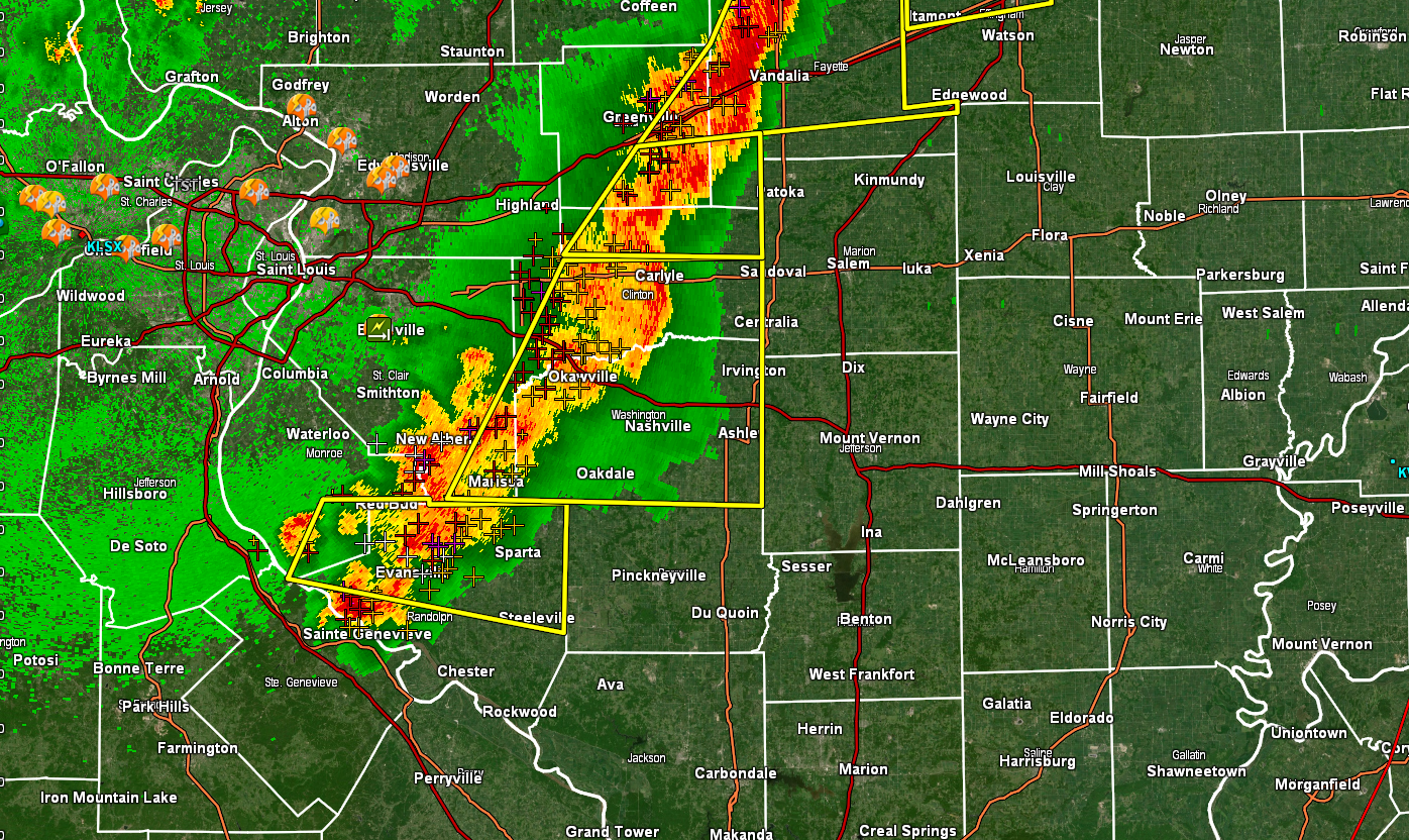
Jackson County, Illinois.
Radar shows damaging wind in several locations in Jackson County. The line of storms is bowing outward. That is usually a sign that high winds are occurring.
Wind damage is likely with this thunderstorm as it continues to move through the county.
Union, Johnson, and Williamson Counties should monitor this storm, as well.
Interactive-city-view radars. Clickable watches and warnings.
https://wtalk.co/B3XHASFZ
Backup radar site in case the above one is not working.
https://weathertalk.com/morani
.
7:50 PM
July 15, 2020. 7:50 PM
Randolph and Jackson County, Illinois
Radar shows rotation on the Randolph/Jackson County line near Wine Hill Road.
Continue to stay weather aware.
Monitor app updates and radars.
Monitor the radars.
Radars and Lightning Data
Interactive city-view radars
http://weatherobservatory.com/weather-radar.htm
A third backup radar
https://weathertalk.com/morani
Clickable watches and warnings can be viewed on the local city-view interactive radars (link above). Be sure and turn on the warnings above the local radars.
A new regional radar we offer
https://imagery.weathertalk.com/prx/RadarLoop.mp4
Lightning data
https://wtalk.co/7QT7WHKU
.
7:31 PM
July 15, 2020. 7:31 PM
Perry County, Missouri. Jackson County, Illinois.
Severe thunderstorms are moving into Perry County, Missouri and Jackson County, Illinois. Storms are moving E SE at 50 mph. They are coming out of the N NW.
These storms could produce wind gusts above 55 mph and quarter size hail.
A tornado watch is also in effect. Short-lived tornadoes are possible with these thunderstorms. Be prepared to seek shelter until the storms pass.
Monitor app updates and radars.
.
7:27 PM
July 15, 2020. 7:26 PM
Randolph County, Missouri.
Tornado Warning for…
Southeastern Randolph County in southwestern Illinois. Until 800 PM CDT.
At 724 PM CDT, a severe thunderstorm capable of producing a tornado was located over Bremen, moving southeast at 25 mph.
.
7:20 PM
.
6:46 PM
July 15, 2020. 6:46 PM.
Perry County, Missouri.
There are intense thunderstorms in Ste. Genevieve County.
There is a chance the line of storms will develop further south.
The atmosphere is unstable. Thunderstorms could produce hail and wind damage.
Monitor app updates and radars.
Radars and Lightning Data
Interactive-city-view radars. Clickable watches and warnings.
https://wtalk.co/B3XHASFZ
Backup radar site in case the above one is not working.
https://weathertalk.com/morani
Regional Radar
Lightning Data (zoom in and out of your local area)
https://wtalk.co/WJ3SN5UZ
.
6:34 PM
July 15, 2020. 6:34 PM.
MO. Bollinger, Scott, and Cape Girardeau Counties.
IL. Union, Williamson, Saline, Gallatin, Johnson, Pope, Hardin, Alexander, Pulaski, and Massac Counties.
KY. Ballard, McCracken, Livingston, Crittenden, Union, Webster, Henderson, Daviess.
I am monitoring thunderstorms over northern portions of southern Illinois.
There is a chance the line of storms will develop further south. For now, I am monitoring radar. There are uncertainties about whether storms will develop and spread southward.
Monitor app updates and radars.
.
6:27 PM
July 15, 2020. 6:27 PM.
Jefferson County.
Storms moving out of Washington County, Illinois, could produce high wind as they move into Jefferson County. The storms have weakened a little bit over the past 30 minutes.
The atmosphere is still unstable over Jefferson County.
Monitor the radars.
Radars and Lightning Data
Interactive city-view radars
http://weatherobservatory.com/weather-radar.htm
A third backup radar
https://weathertalk.com/morani
Clickable watches and warnings can be viewed on the local city-view interactive radars (link above). Be sure and turn on the warnings above the local radars.
A new regional radar we offer
https://imagery.weathertalk.com/prx/RadarLoop.mp4
Lightning data
https://wtalk.co/7QT7WHKU
6:24 PM
July 15, 2020. 6:22 PM.
Randolph, Perry, and Jackson Counties.
A severe thunderstorm was located near Ellis Grove and Sparta, IL. The storms are moving east at 50 mph.
These storms may clip northern Jackson County, Illinois. They may also impact portions of Franklin County.
They WILL impact Perry and Jefferson Counties in southern Illinois.
The storms have a history of producing wind damage and nickel size hail. Larger hail is possible.
Short-lived tornadoes can’t be ruled out. Be prepared to seek shelter from this line of thunderstorms.
Interactive city-view radars
http://weatherobservatory.com/weather-radar.htm
A third backup radar
https://weathertalk.com/morani
Clickable watches and warnings can be viewed on the local city-view interactive radars (link above). Be sure and turn on the warnings above the local radars.
A new regional radar we offer
https://imagery.weathertalk.com/prx/RadarLoop.mp4
Lightning data
https://wtalk.co/7QT7WHKU
6:18 PM
July 15, 2020. 6:18 PM.
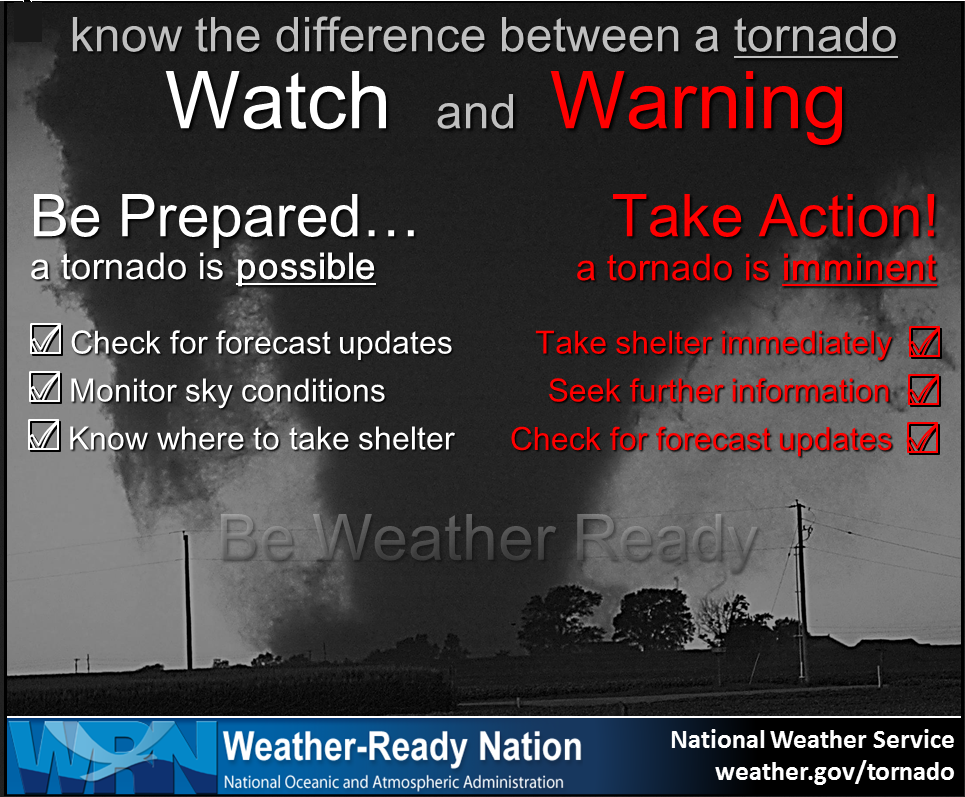
Tornado Watch
A tornado watch will be in effect this evening for portions of southern Illinois.
A watch means that conditions are favorable for severe weather. A warning means to seek shelter.
The watch was recently expanded to include Franklin, Jefferson, Hamilton, and White.
Remember, the tornado watch is in and CLOSE to the above mentioned area. Storms don’t follow our boundaries.
Severe storms are most likely from Randolph County eastward across Perry, Franklin, Jefferson, Hamilton, and White Counties.
Counties south of that line should also monitor radars and updates.
Storms may produce quarter size hail, 70 mph wind gusts, and even a tornado.
6 PM
From the Paducah, Kentucky, NWS
We are closely monitoring the line of convection moving towards Perry and Jefferson counties IL. It has had a history of producing winds of 60 to 70 mph across the St Louis area. Stll unsure if a downstream severe watch will be issued, as the environment becomes less supportive for severe the closer the storms get to the Wabash River Valley. So the severe threat may only end up impacting a limited portion of our area. Stay tuned!
End of their comment.
Line of storms approaching from the west (our northern counties). There could be wind damage with this line. Hail is possible. A tornado can’t be ruled out.
Be ready to seek shelter.
Radars
Interactive city-view radars
http://weatherobservatory.com/weather-radar.htm
A third backup radar
https://weathertalk.com/morani
Clickable watches and warnings can be viewed on the local city-view interactive radars (link above). Be sure and turn on the warnings above the local radars.
A new regional radar we offer
https://imagery.weathertalk.com/prx/RadarLoop.mp4
Lightning data
https://wtalk.co/7QT7WHKU
.
2:08 PM
THE NWS STORM PREDICTION CENTER HAS ISSUED A

* TORNADO WATCH FOR PORTIONS OF
  EASTERN ILLINOIS
  SOUTHWEST AND CENTRAL MISSOURI

* EFFECTIVE THIS WEDNESDAY AFTERNOON AND EVENING FROM 210 PM
  UNTIL 900 PM CDT.

* PRIMARY THREATS INCLUDE...
  A FEW TORNADOES POSSIBLE
  SCATTERED DAMAGING WIND GUSTS TO 70 MPH LIKELY
  SCATTERED LARGE HAIL EVENTS TO 1.5 INCHES IN DIAMETER POSSIBLE

SUMMARY...AN REMNANT MCV AND ITS RELATED STRONG DEEP-LAYER/LOW-LEVEL
WINDS WILL SUPPORT SUPERCELL THUNDERSTORMS AS WELL AS ORGANIZING
LINEAR BOWING STORMS THROUGH MID/LATE AFTERNOON. A FEW TORNADOES ARE
POSSIBLE ASIDE FROM MORE PREVALENT DAMAGING THUNDERSTORM WINDS.
SEVERE HAIL MAY ALSO OCCUR.

1:12 PM
Special statement from the Storm Prediction Center
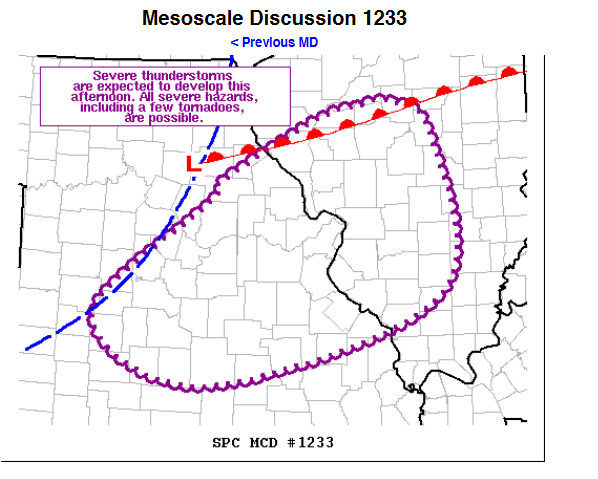
Mesoscale Discussion 1233
NWS Storm Prediction Center Norman OK
0110 PM CDT Wed Jul 15 2020
Areas affected…Central/Eastern MO…Southwest/Central IL
Concerning…Severe potential…Watch likely
Valid 151810Z – 152015Z
Probability of Watch Issuance…80 percent
SUMMARY…Severe thunderstorms capable of all severe hazards,
including a few tornadoes, are anticipated this afternoon from
central MO into central IL.
DISCUSSION…Regional radar and satellite imagery reveals an MCV
from last night’s storms just east of MKC, with associated showers
and thunderstorms (and attendant cloud cover) spreading
eastward/northeastward from northern/central MO into
northern/central IL. Broad area of low surface pressure associated
with this MCV exists from central MO to near the MO/IA/IL border
intersection, with an embedded surface low over central MO (about 40
miles north of COU). Outflow-reinforced boundary extending
southwestward from this low has effectively become the cold front,
while a warm front also extends from this low east-northeastward
into central IL.
The warm sector is currently characterized by temperatures in the
mid 80s, mid 70s dewpoints, and weak southerly/southeastward surface
winds. Some convective inhibition remains, but the combination of
continued diurnal heating and ascent attendant to the front and MCV
is expected to overcome this inhibition, resulting in convective
initiation. Warm and moist conditions will support moderate
instability. Enhanced mid-level flow atop the
southerly/southeasterly surface winds will result in moderate
vertical shear, with at least some modest low-level curvature. The
resulting environment conditions are supportive of initially
discrete storms capable of all severe hazards, including a few
tornadoes. Linear character to the ascent suggests growth into one
or more bowing segments, or perhaps even a coherent convective line,
is likely. Once this occurs, the primary severe threat will
transition to damaging wind gusts.
..Mosier/Guyer.. 07/15/2020
8 AM update.
A complex of thunderstorms will impact the region later this afternoon into tonight.
Some of these storms will be severe. The risk is highest over the northern half of southeast Missouri and then northern half of southern Illinois.
The threat is highest along and north of Bollinger and Cape Girardeau Counties in southeast Missouri and along and north of a line from Jackson, Williamson, Saline, and Gallatin Counties in southern Illinois. The threat of severe weather south of that line is less certain. That does not mean you are out of the woods. Monitor updates.
I will post updates on this page throughout the event. Check back.
Storm Prediction Center severe weather outlook.
Here is the latest Storm Prediction Center outlook. Remember, don’t pay too much attention to the different colors. Focus on the actual forecast. The forecast is for a few severe thunderstorms.
The black outline is our local area.
Light green is where thunderstorms may occur but should be below severe levels.
Dark green is a level one risk. Yellow is a level two risk. Orange is a level three (enhanced) risk. Red is a level four (moderate) risk. Pink is a level five (high) risk.
One is the lowest risk. Five is the highest risk.
A severe storm is one that produces 58 mph wind or higher, quarter size hail, and/or a tornado.

.
Future-cast radars
What am I looking at?
You are looking at different models. Meteorologists use many different models to forecast the weather. All models are wrong. Some are more wrong than others. Meteorologists have to make a forecast based on the guidance/models.
I show you these so you can see what the different models are showing as far as precipitation. If most of the models agree, then the confidence in the final weather forecast increases.
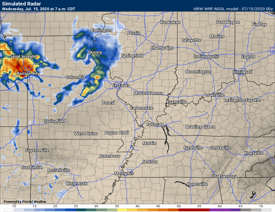
This animation is the Hrrr model.
This animation shows you what radar might look like as the next system pulls through the region. It is a future-cast radar.
Green is rain. Blue is snow. Pink and red represent sleet and freezing rain.
Time-stamp upper left. Click the animation to enlarge it.
Models handle afternoon and evening thunderstorms poorly. Keep that in mind.

This animation is the SPC WRF model.
This animation shows you what radar might look like as the next system pulls through the region. It is a future-cast radar.
Green is rain. Blue is snow. Pink and red represent sleet and freezing rain.
Time-stamp upper left. Click the animation to enlarge it.
Models handle afternoon and evening thunderstorms poorly. Keep that in mind.
.
This animation is the 3K American Model.
This animation shows you what radar might look like as the next system pulls through the region. It is a future-cast radar.
Green is rain. Blue is snow. Pink and red represent sleet and freezing rain.
Time-stamp upper left. Click the animation to enlarge it.
Models handle afternoon and evening thunderstorms poorly. Keep that in mind.
.
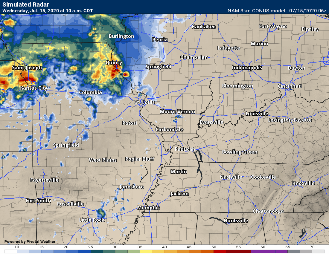
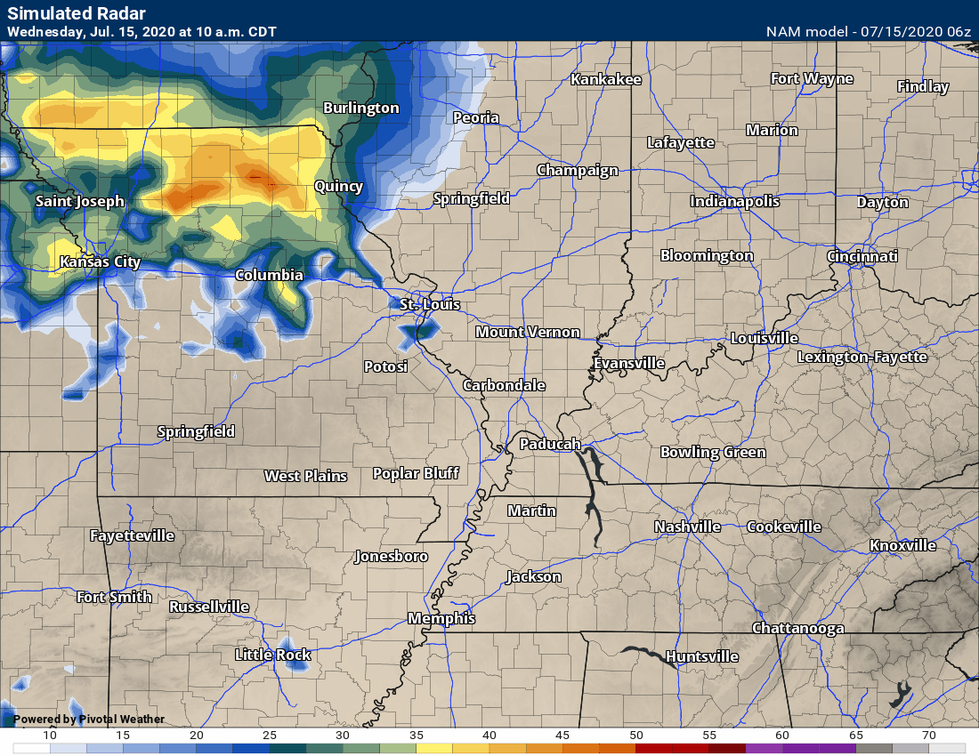
This next animation is the NAM American Model.
This animation shows you what radar might look like as the system pulls through the region. It is a future-cast radar.
Green is rain. Blue is snow. Pink and red represent sleet and freezing rain.
Time-stamp upper left. Click the animation to enlarge it.
Models handle afternoon and evening thunderstorms poorly. Keep that in mind.
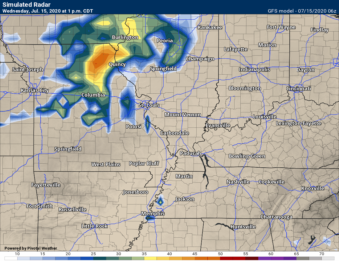
This next animation is the GFS American Model.
This animation shows you what radar might look like as the system pulls through the region. It is a future-cast radar.
Green is rain. Blue is snow. Pink and red represent sleet and freezing rain.
Time-stamp upper left. Click the animation to enlarge it.
Models handle afternoon and evening thunderstorms poorly. Keep that in mind.
.
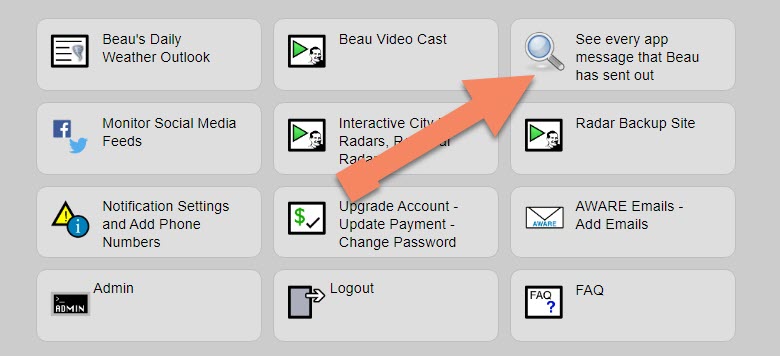
Note: We added a “see all” button on the website. This allows you to see every message that I have sent out (to all my forecast counties).
Here is the link. Click here.
To view the live radars, visit these links.
Radars
Interactive city-view radars
http://weatherobservatory.com/weather-radar.htm
A third backup radar
https://weathertalk.com/morani
Clickable watches and warnings can be viewed on the local city-view interactive radars (link above). Be sure and turn on the warnings above the local radars.
A new regional radar we offer
https://imagery.weathertalk.com/prx/RadarLoop.mp4
Lightning data
https://wtalk.co/7QT7WHKU
.
Storm Prediction Center severe weather outlook.
Here is the latest Storm Prediction Center outlook. Remember, don’t pay too much attention to the different colors. Focus on the actual forecast. The forecast is for a few severe thunderstorms.
The black outline is our local area.
Light green is where thunderstorms may occur but should be below severe levels.
Dark green is a level one risk. Yellow is a level two risk. Orange is a level three (enhanced) risk. Red is a level four (moderate) risk. Pink is a level five (high) risk.
One is the lowest risk. Five is the highest risk.
A severe storm is one that produces 58 mph wind or higher, quarter size hail, and/or a tornado.
.
Tomorrow’s severe weather outlook.

Not receiving app/text messages?
USE THE APP. ATT and Verizon are slowing or stopping the text messages.
Make sure you have the correct app/text options turned on. Find those under the personal notification settings tab at www.weathertalk.com. Red is off. Green is on.
Subscribers, PLEASE USE THE APP. ATT and Verizon are not reliable during severe weather. They are delaying text messages.
The app is under WeatherTalk in the app store.

Apple users click here

Android users click here
.

Live lightning data: Click here.