.
Click one of the links below to take you directly to that section
![]()
![]()
![]()
![]()
![]()
![]()
![]()
Do you have any suggestions or comments? Email me at beaudodson@usawx.com
.
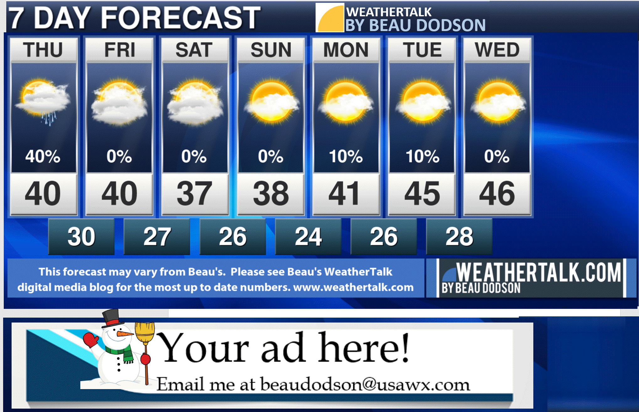
7-day forecast for southeast Missouri, southern Illinois, western Kentucky, and western Tennessee.
This is a BLEND for the region. See the detailed region by region forecast further down in this post.
The entire blog is updated after 3 PM each day. Some adjustments may be made during the morning hours.
The short/long range graphics are updated before 9 AM.
.


.
.

.
Thursday to Thursday
1. Are accumulating snow or ice in the forecast? Unlikely. Some light accumulation on the grass may occur Wednesday night/Thursday morning. Even this seems to be a stretch. No real concerns for travel.
2. Is lightning in the forecast? No.
3. Are severe thunderstorms in the forecast? No.
* The NWS officially defines a severe thunderstorm as a storm with 58 mph wind or greater, 1″ hail or larger, and/or tornadoes
4. Is flash flooding in the forecast? No.
6. Will the wind chill dip below 10 degrees above zero? No.
..

It may remain dry over portions of southeast Illinois and northwest Kentucky with the mid-week system. It may be just a tad too far south to impact the entire region. Keep that in mind.
Here is an example from one model. Just showing you the general idea.

January 7, 2020
How confident am I that this days forecast will verify? Medium Confidence
Thursday Forecast: Mostly cloudy. A chance of a rain or snow shower. Little or no accumulation. Portions of southern Illinois and northwest Kentucky may remain dry.
What is the chance of precipitation? SE MO ~ 40% (esp south) not as much north IL ~ 30% esp far south KY ~ 30% TN ~ 50%
Temperature range: MO Bootheel 38° to 42° SE MO 38° to 42° South IL 38° to 42° Northwest KY (near Indiana border) 40° to 44° West KY 40° to 44° NW TN 40° to 44°
Wind direction and speed: North northeast 10 to 20 mph
Wind chill or heat index (feels like) temperature forecast: 30° to 40°
Coverage of precipitation: Scattered (mainly southern counties in my forecast area)
What impacts are anticipated from the weather? Wet roadways.
Should I cancel my outdoor plans? No, but check radars.
UV Index: 2. Low.
Sunrise: 7:10 AM
Sunset: 4:54 PM
.
Thursday night Forecast: Mostly cloudy. Any remaining rain or snow showers will end. Mainly southern Kentucky and Tennessee.
What is the chance of precipitation? SE MO ~ 0% IL ~ 0% KY ~ 20% TN ~ 20%
Temperature range: MO Bootheel 30° to 32° SE MO 28° to 32° South IL 28° to 32° Northwest KY (near Indiana border) 28° to 32° West KY 28° to 32° NW TN 30° to 32°
Wind direction and speed: North northwest 7 to 14 mph
Wind chill or heat index (feels like) temperature forecast: 24° to 30°
Coverage of precipitation: None
What impacts are anticipated from the weather? None
Should I cancel my outdoor plans? No
Moonrise: 1:03 AM
Moonset: 12:32 PM
The phase of the moon: Waning Crescent
.
January 8, 2020
How confident am I that this days forecast will verify? High Confidence
Friday Forecast: Intervals of clouds.
What is the chance of precipitation? SE MO ~ 0% IL ~ 0% KY ~ 0% TN ~ 0%
Temperature range: MO Bootheel 38° to 42° SE MO 38° to 42° South IL 38° to 42° Northwest KY (near Indiana border) 40° to 42° West KY 40° to 44° NW TN 42° to 45°
Wind direction and speed: North 8 to 16 mph
Wind chill or heat index (feels like) temperature forecast: 30° to 40°
Coverage of precipitation: None
What impacts are anticipated from the weather? None
Should I cancel my outdoor plans? No
UV Index: 2. Low.
Sunrise: 7:10 AM
Sunset: 4:55 PM
.
Friday night Forecast: Mostly cloudy.
What is the chance of precipitation? SE MO ~ 0% IL ~ 0% KY ~ 0% TN ~ 0%
Temperature range: MO Bootheel 26° to 30° SE MO 25° to 30° South IL 25° to 30° Northwest KY (near Indiana border) 26° to 30° West KY 26° to 30° NW TN 28° to 32°
Wind direction and speed: North 6 to 12 mph
Wind chill or heat index (feels like) temperature forecast: 20° to 28°
Coverage of precipitation: None
What impacts are anticipated from the weather? None
Should I cancel my outdoor plans? No
Moonrise: 2:13 AM
Moonset: 1:07 PM
The phase of the moon: Waning Crescent
.
January 9, 2020
How confident am I that this days forecast will verify? High Confidence
Saturday Forecast: Intervals of clouds.
What is the chance of precipitation? SE MO ~ 0% IL ~ 0% KY ~ 0% TN ~ 0%
Temperature range: MO Bootheel 40° to 44° SE MO 36° to 42° South IL 36° to 42° Northwest KY (near Indiana border) 38° to 42° West KY 40° to 44° NW TN 40° to 44°
Wind direction and speed: North 5 to 10 mph
Wind chill or heat index (feels like) temperature forecast: 34° to 40°
Coverage of precipitation: None
What impacts are anticipated from the weather? None
Should I cancel my outdoor plans? No
UV Index: 2. Low.
Sunrise: 7:10 AM
Sunset: 4:56 PM
.
Saturday night Forecast: Partly cloudy.
What is the chance of precipitation? MO Bootheel 24° to 28° SE MO 23° to 27° South IL 23° to 26° Northwest KY (near Indiana border) 24° to 28° West KY 24° to 28° NW TN 24° to 28°
Wind direction and speed: North 4 to 8 mph
Wind chill or heat index (feels like) temperature forecast: 20° to 25°
Coverage of precipitation: None
What impacts are anticipated from the weather? None
Should I cancel my outdoor plans? No
Moonrise: 3:26 AM
Moonset: 1:46 PM
The phase of the moon: Waning Crescent
.
January 10, 2020
How confident am I that this days forecast will verify? High Confidence
Sunday Forecast: Mostly cloudy.
What is the chance of precipitation? SE MO ~ 0% IL ~ 0% KY ~ 0% TN ~ 0%
Temperature range: MO Bootheel 40° to 44° SE MO 36° to 42° South IL 36° to 42° Northwest KY (near Indiana border) 38° to 42° West KY 38° to 42° NW TN 38° to 42°
Wind direction and speed: North at 6 to 12 mph
Wind chill or heat index (feels like) temperature forecast: 33° to 36°
Coverage of precipitation: None
What impacts are anticipated from the weather? None
Should I cancel my outdoor plans? No
UV Index: 2. Low.
Sunrise: 7:10 AM
Sunset: 4:57 PM
.
Sunday night Forecast: Partly cloudy.
What is the chance of precipitation? SE MO ~ 0% IL ~ 0% KY ~ 0% TN ~ 0%
Temperature range: MO Bootheel 23° to 26° SE MO 22° to 24° South IL 22° to 24° Northwest KY (near Indiana border) 23° to 26° West KY 23° to 26° NW TN 24° to 26°
Wind direction and speed: North 4 to 8 mph
Wind chill or heat index (feels like) temperature forecast: 20° to 25°
Coverage of precipitation: None
What impacts are anticipated from the weather? None
Should I cancel my outdoor plans? No
Moonrise: 4:37 AM
Moonset: 2:32 PM
The phase of the moon: Waning Crescent
.
January 11, 2020
How confident am I that this days forecast will verify? High Confidence
Monday Forecast: Partly sunny.
What is the chance of precipitation? SE MO ~ 0% IL ~ 0% KY ~ 0% TN ~ 0%
Temperature range: MO Bootheel 38° to 40° SE MO 36° to 40° South IL 36° to 40° Northwest KY (near Indiana border) 40° to 42° West KY 40° to 44° NW TN 42° to 44°
Wind direction and speed:
Wind chill or heat index (feels like) temperature forecast: 34° to 40°
Coverage of precipitation: None
What impacts are anticipated from the weather? None
Should I cancel my outdoor plans? No
UV Index: 2. Low.
Sunrise: 7:10 AM
Sunset: 4:58 PM
.
Monday night Forecast: Partly cloudy.
What is the chance of precipitation? SE MO ~ 0% IL ~ 0% KY ~ 0% TN ~ 0%
Temperature range: MO Bootheel 23° to 26° SE MO 22° to 24° South IL 22° to 24° Northwest KY (near Indiana border) 23° to 26° West KY 23° to 26° NW TN 24° to 26°
Wind direction and speed: West 4 to 8 mph
Wind chill or heat index (feels like) temperature forecast: 20° to 25°
Coverage of precipitation: None
What impacts are anticipated from the weather? None
Should I cancel my outdoor plans? No
Moonrise: 5:47 AM
Moonset: 3:27 PM
The phase of the moon: Waning Crescent
.

.
The AM AG weather report will return in late winter and early spring (when growing season returns).
Please refer to the long range video until that time.
.
![]()
![]()
Graphic-cast
Click here if you would like to return to the top of the page.
Illinois
During active weather check my handwritten forecast towards the top of the page.

.
Kentucky
During active weather check my handwritten forecast towards the top of the page.


.

.

.
Tennessee
During active weather check my handwritten forecast towards the top of the page.

.
.
Today through January 15th. Severe weather is not anticipated.
.
Today’s outlook (below).
Light green is where thunderstorms may occur but should be below severe levels.
Dark green is a level one risk. Yellow is a level two risk. Orange is a level three (enhanced) risk. Red is a level four (moderate) risk. Pink is a level five (high) risk.
One is the lowest risk. Five is the highest risk.
A severe storm is one that produces 58 mph wind or higher, quarter size hail, and/or a tornado.
The tan states are simply a region that SPC outlined on this particular map. Just ignore that.

The black outline is our local area.

.
Tomorrow’s severe weather outlook.

.

.
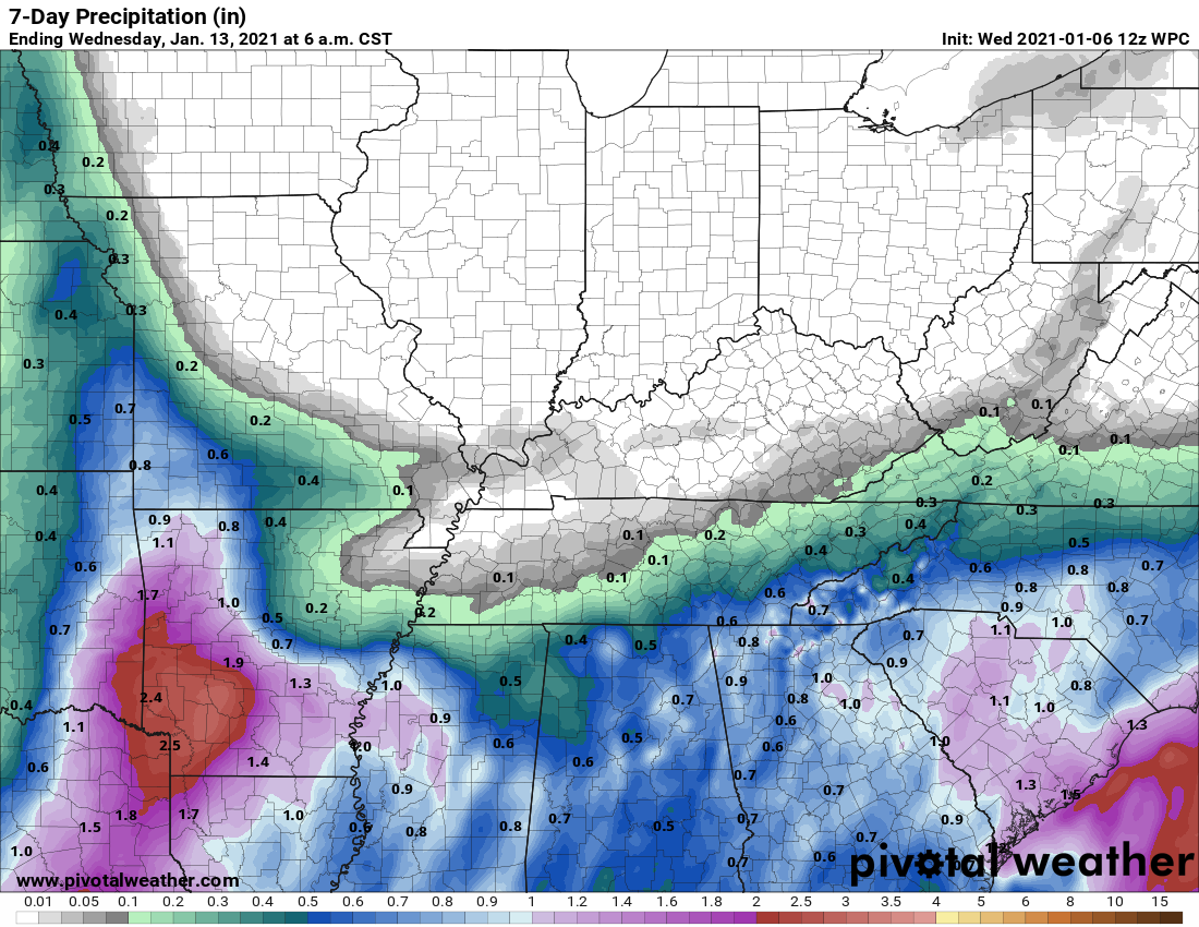
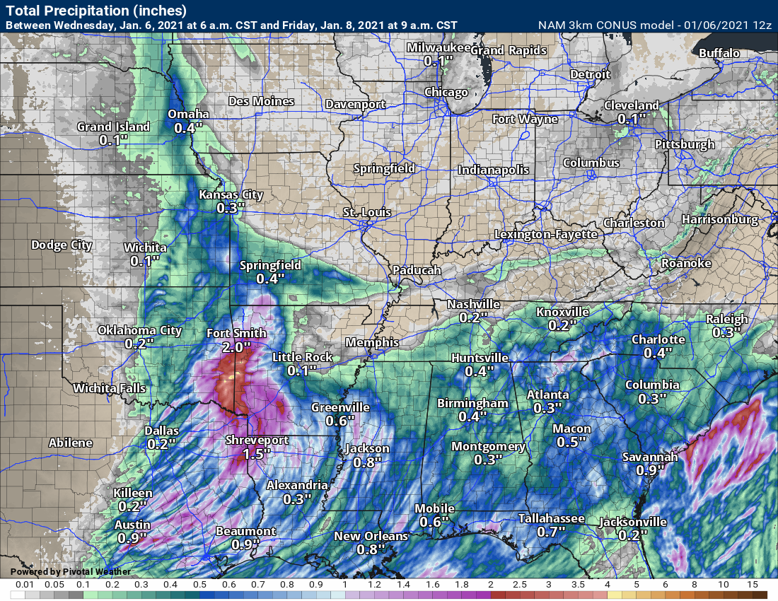
The images below are from the WPC. Their totals are a bit lower than our current forecast. I wanted to show you the comparison.
24-hour precipitation outlook.
.
 .
.
48-hour precipitation outlook.
.
.
72-hour precipitation outlook.
.
![]()

![]()
..
Weather advice:
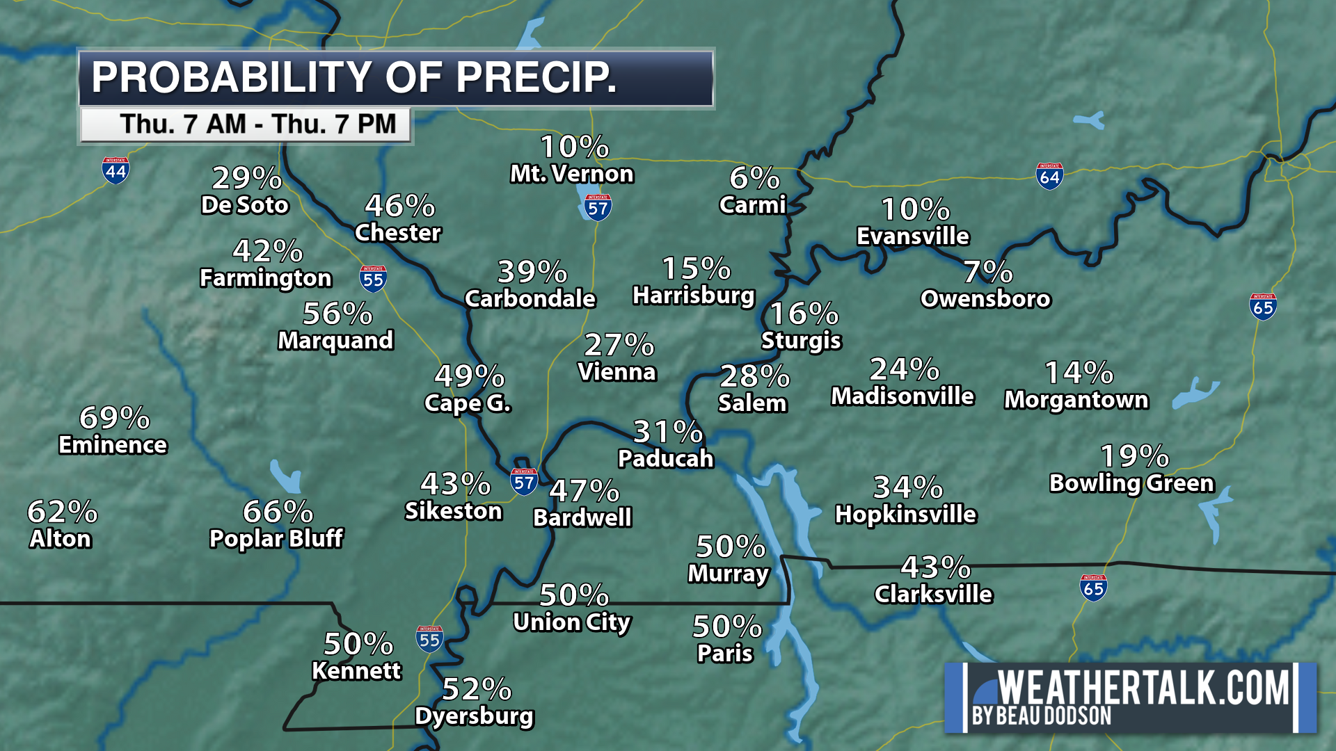
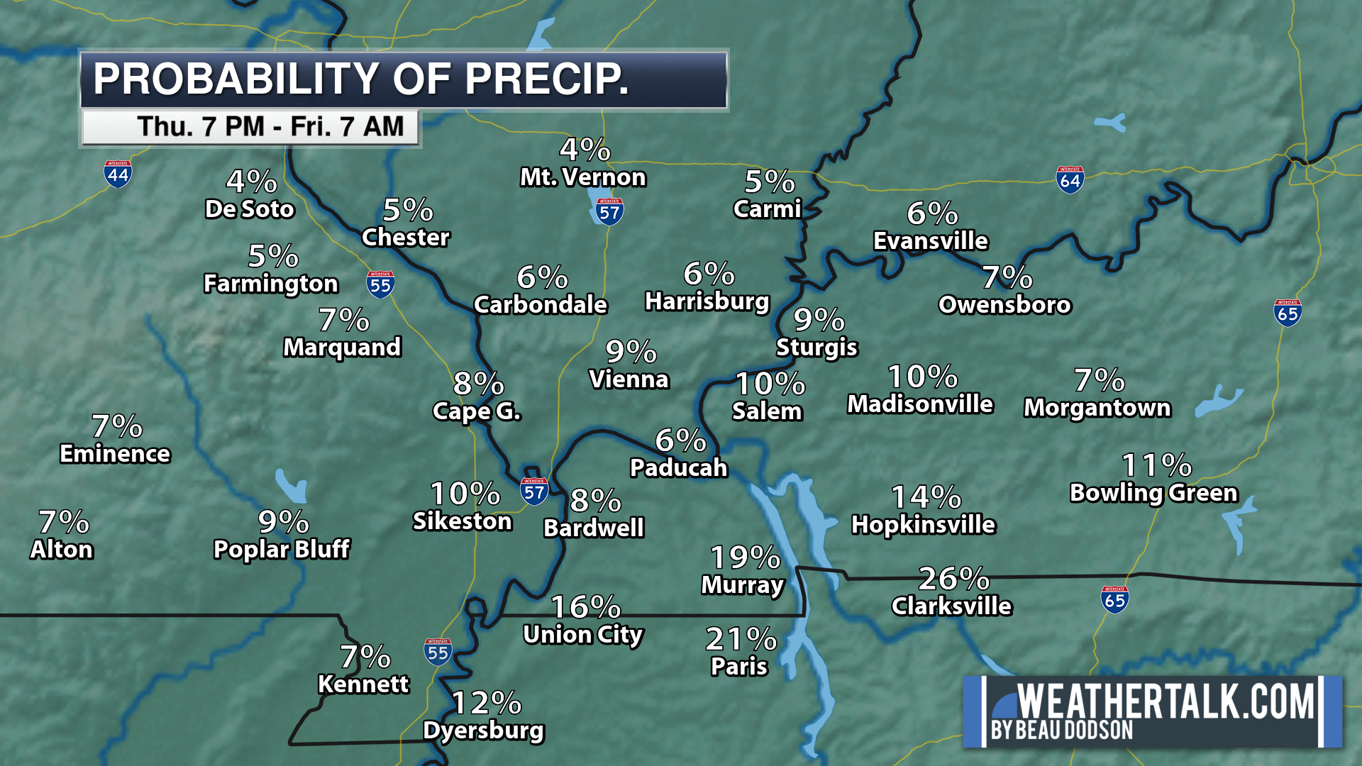
Some light snow is possible Wednesday night and Thursday. At this time, any accumulation is expected to be light. Grassy surfaces, at best.
Beau’s Weather Talk App by the Fire Horn. Download it. Install it. It is for subscribers. Not a subscriber? Go to www.weathertalk.com/welcome
.
Weather Discussion

-
- Fast moving system Wednesday into Thursday. Scattered precipitation chances.
- No extremes.
This is a light rain event and many areas will remain dry. Keep that in mind. Mainly tonight into tomorrow evening.
The primary weather story remains the same. Plenty of clouds over the coming days. Some light rain and rain/snow showers (mainly our southern counties).
The storm system is currently over the central plains. It is moving east and southeast and will brush our region.
We will see thickening clouds today over the region. Most likely dry.
Showers will begin to increase ovre southwest Missouri and Arkansas today and this evening. That precipitation will then spread east/southeast.
It may be cold enough for some rain rain/snow mix. Accumulation, if any, would be on grassy surfaces. This is not expected to be a big deal. Travel issues are not anticipated.
Much of the region may not experience measurable rainfall.
Those that do pick up some rain, will likely receive less than 0.25″.
Model guidance over the past 24 hours has shifted the entire system slightly further south. It does not take much of a shift to keep most of my forecast counties dry.
Gusty winds will be with us Thursday and Friday. That will make it feel a bit cooler with the wind chill. Nothing extreme.
Friday into Monday will deliver quite a few clouds. Several weak fast moving systems will be responsible for the cloud cover. Rain chances will be low.
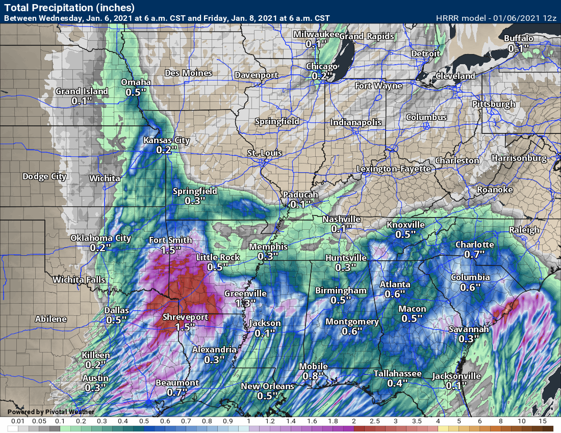
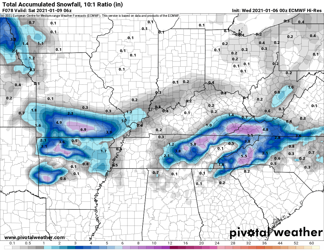
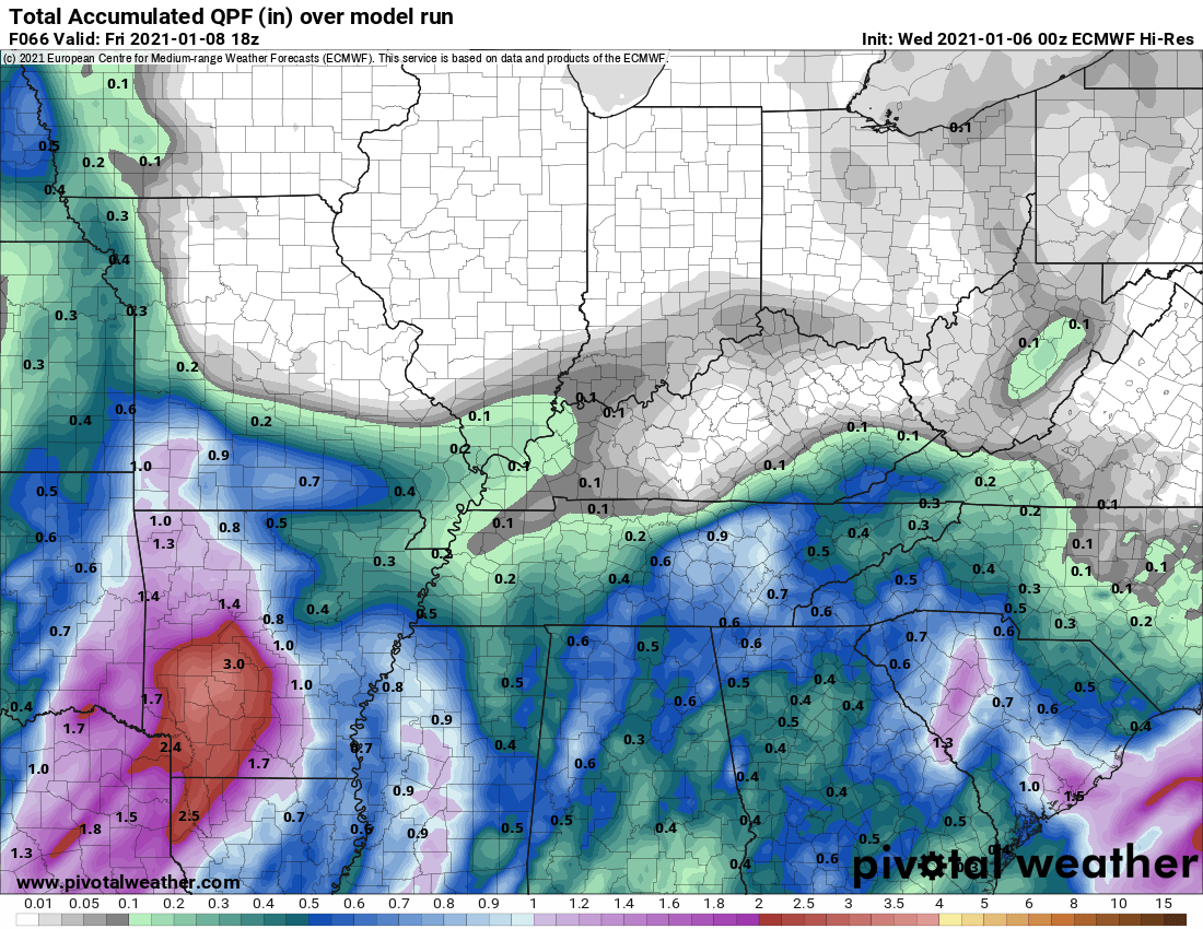
Let me show you a few more precipitation totals maps.
Rain
Snow
Rain
Snow
Rain
.


Click here if you would like to return to the top of the page.
Again, as a reminder, these are models. They are never 100% accurate. Take the general idea from them.
What should I take from these?
- The general idea and not specifics. Models usually do well with the generalities.
- The time-stamp is located in the upper left corner.
- The EC European weather model is in Zulu time.
.
What am I looking at?
You are looking at different models. Meteorologists use many different models to forecast the weather. All models are wrong. Some are more wrong than others. Meteorologists have to make a forecast based on the guidance/models.
I show you these so you can see what the different models are showing as far as precipitation. If most of the models agree, then the confidence in the final weather forecast increases.
You can see my final forecast at the top of the page.
.
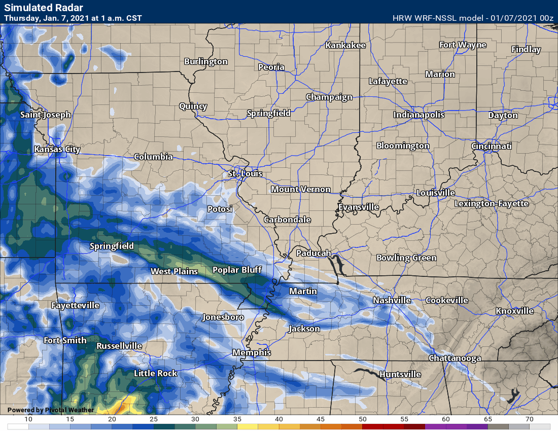
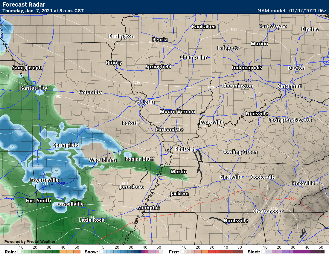
This animation is the Storm Prediction Center WRF model.
This animation shows you what radar might look like as the next system pulls through the region. It is a future-cast radar.
Time-stamp upper left. Click the animation to enlarge it.
.
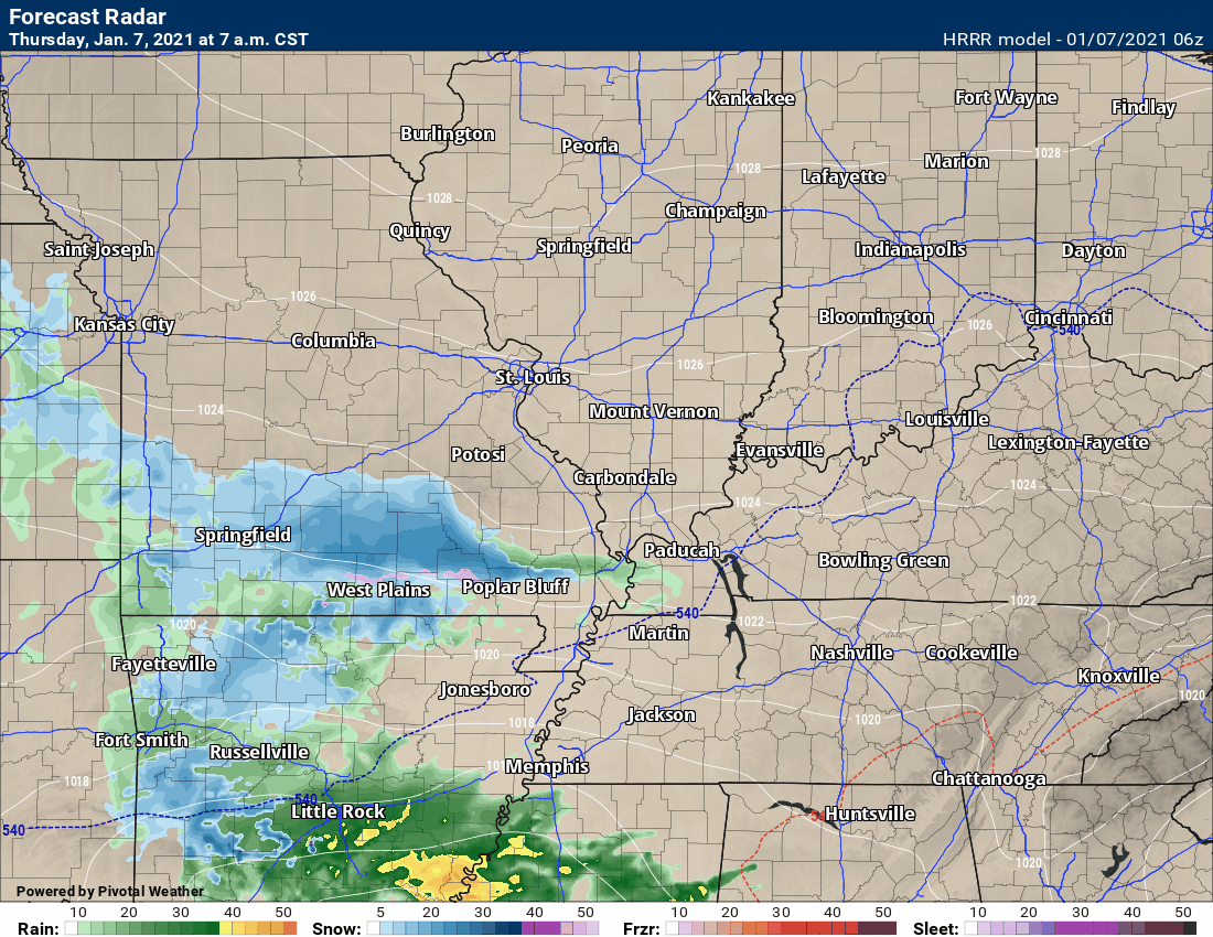
This animation is the Hrrr short-range model.
.
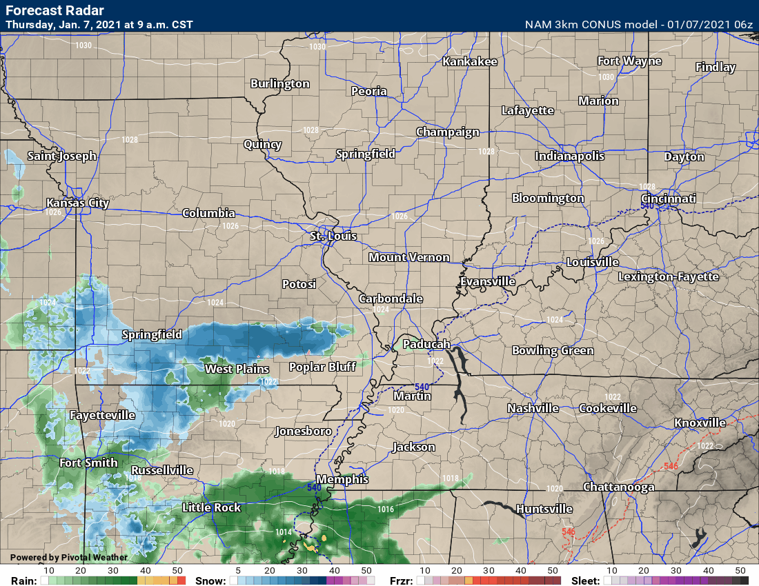
This animation is the 3K NAM American Model.
This animation shows you what radar might look like as the next system pulls through the region. It is a future-cast radar.
Time-stamp upper left. Click the animation to enlarge it.
.
.
This next animation is the lower-resolution NAM American Model.
This animation shows you what radar might look like as the system pulls through the region. It is a future-cast radar.
Time-stamp upper left. Click the animation to enlarge it.
.
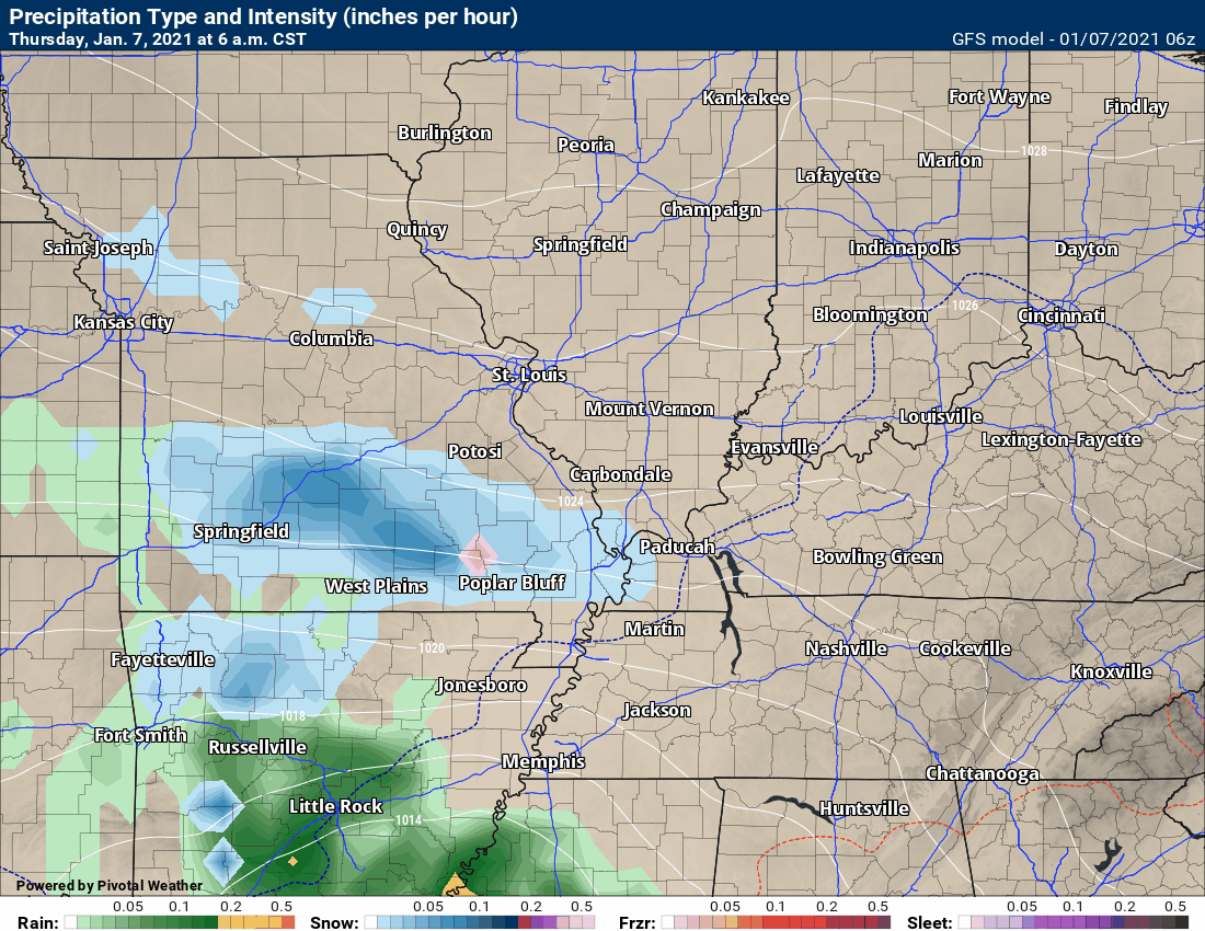
This next animation is the GFS American Model.
This animation shows you what radar might look like as the system pulls through the region. It is a future-cast radar.
Time-stamp upper left. Click the animation to enlarge it.
.
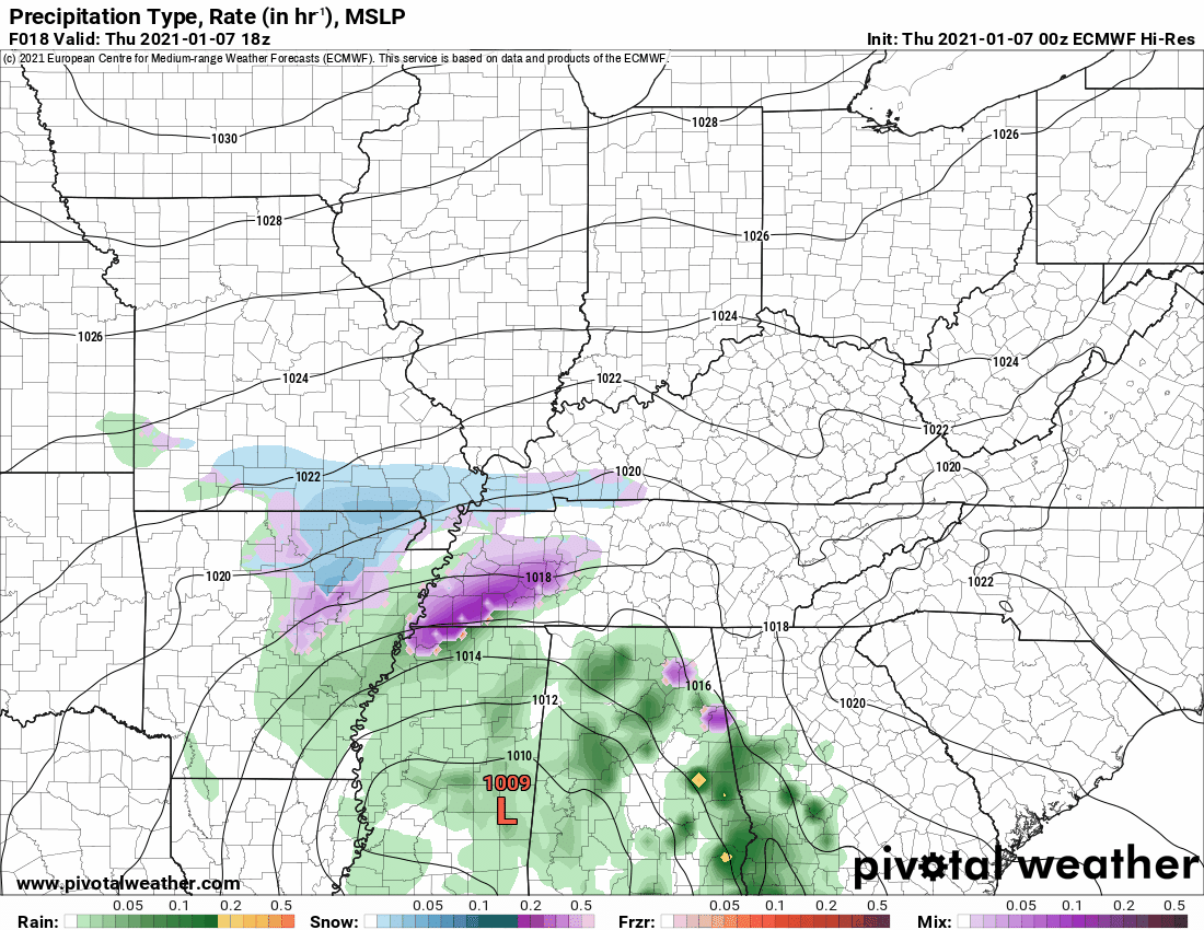
This next animation is the EC European Weather model.
This animation shows you what radar might look like as the system pulls through the region. It is a future-cast radar.
Time-stamp upper left. Click the animation to enlarge it.
.
![]()
.


.
Click here if you would like to return to the top of the page.
.
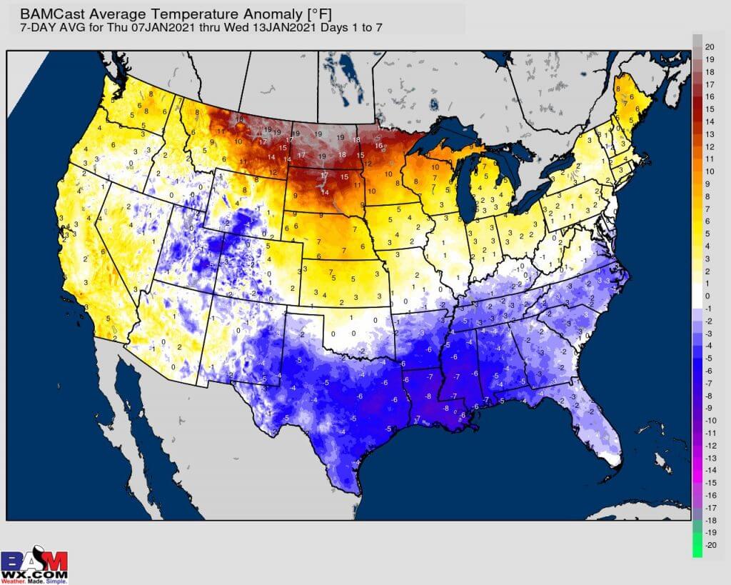
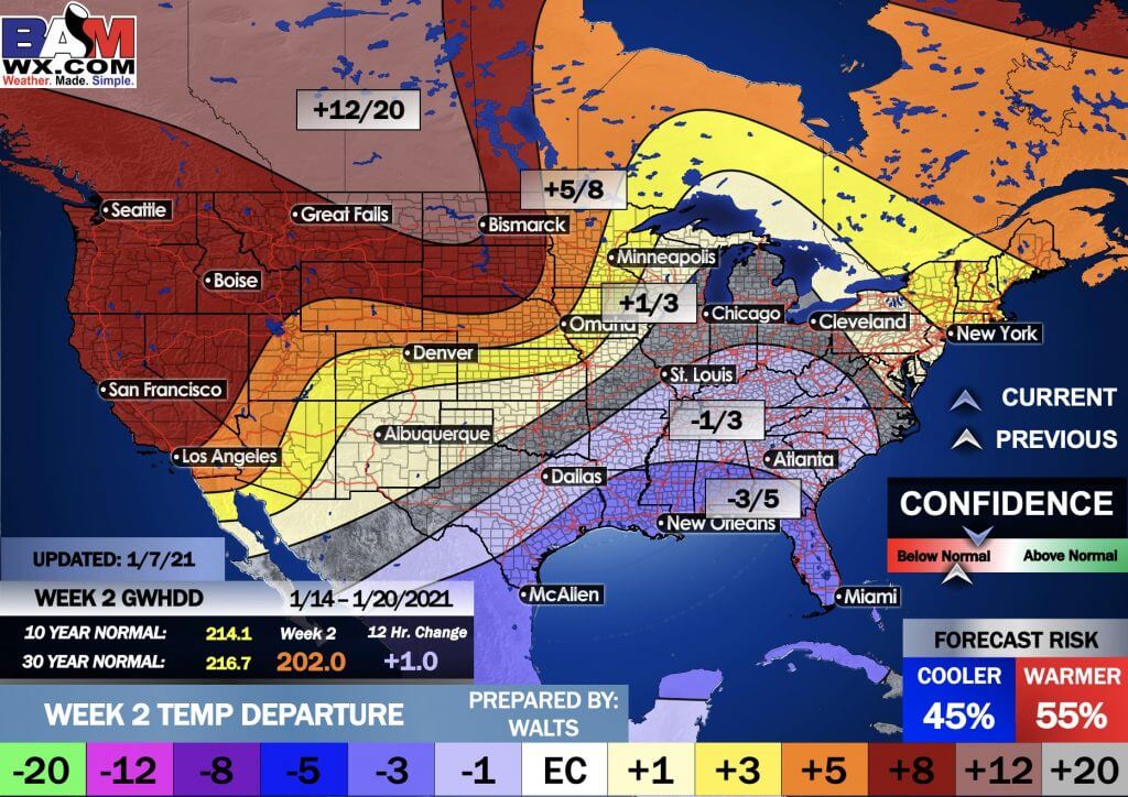
Average high temperatures for this time of the year are around 44 degrees.
Average low temperatures for this time of the year are around 27 degrees.
Average precipitation during this time period ranges from 0.70″ to 1.00″
Yellow and orange colors are above average temperatures. Red is much above average. Light blue and blue are below-average temperatures. Green to purple colors represents much below-average temperatures.
This outlook covers January 7th through January 13th
Click on the image to expand it.
.
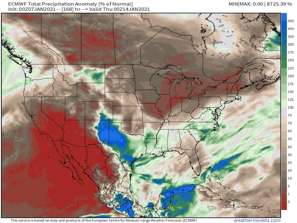
The precipitation forecast is PERCENT OF AVERAGE. Brown is below average. Green is above average. Blue is much above average.
.

Average low temperatures for this time of the year are around 26 degrees
Average precipitation during this time period ranges from 0.70″ to 1.00″
.
This outlook covers January 14th through January 20th
Click on the image to expand it.
.
The precipitation forecast is PERCENT OF AVERAGE. Brown is below average. Green is above average. Blue is much above average.
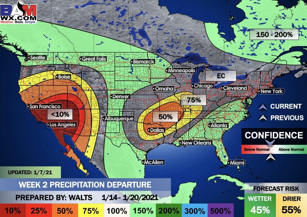
.
.

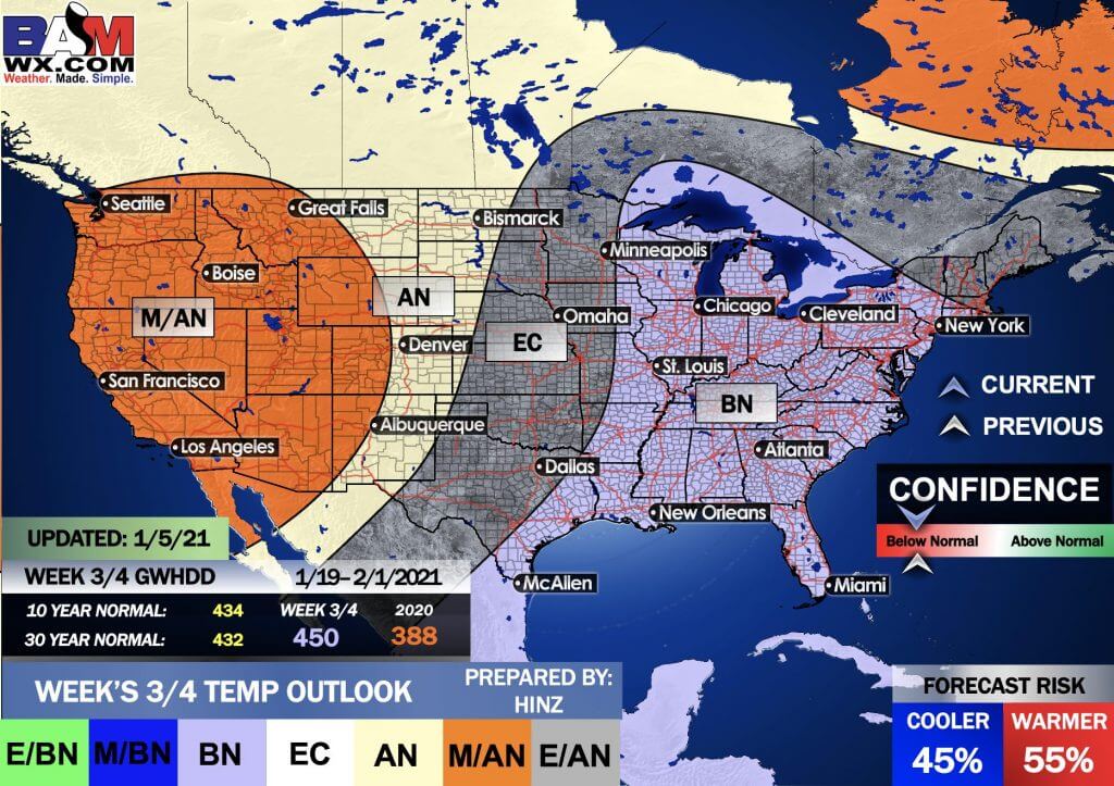
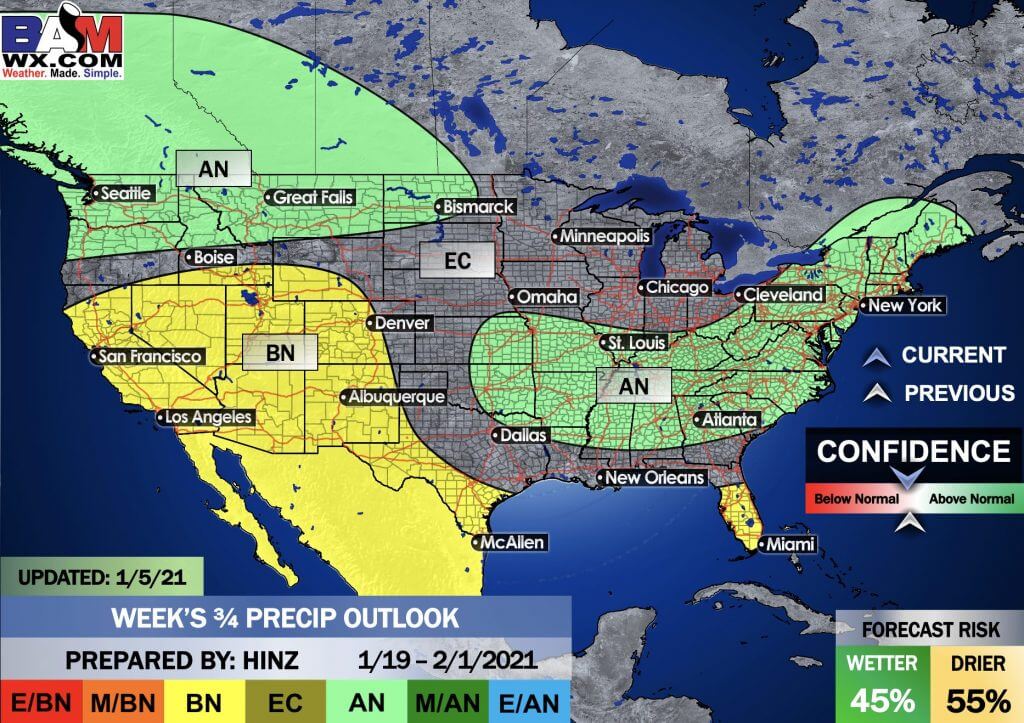
EC = Equal chances of above or below average
BN= Below average
M/BN = Much below average
AN = Above average
M/AN = Much above average
E/AN = Extremely above average
Average low temperatures for this time of the year are around 24 degrees
Average precipitation during this time period ranges from 1.40″ to 2.00″
This outlook covers January 19th through February 1st
.
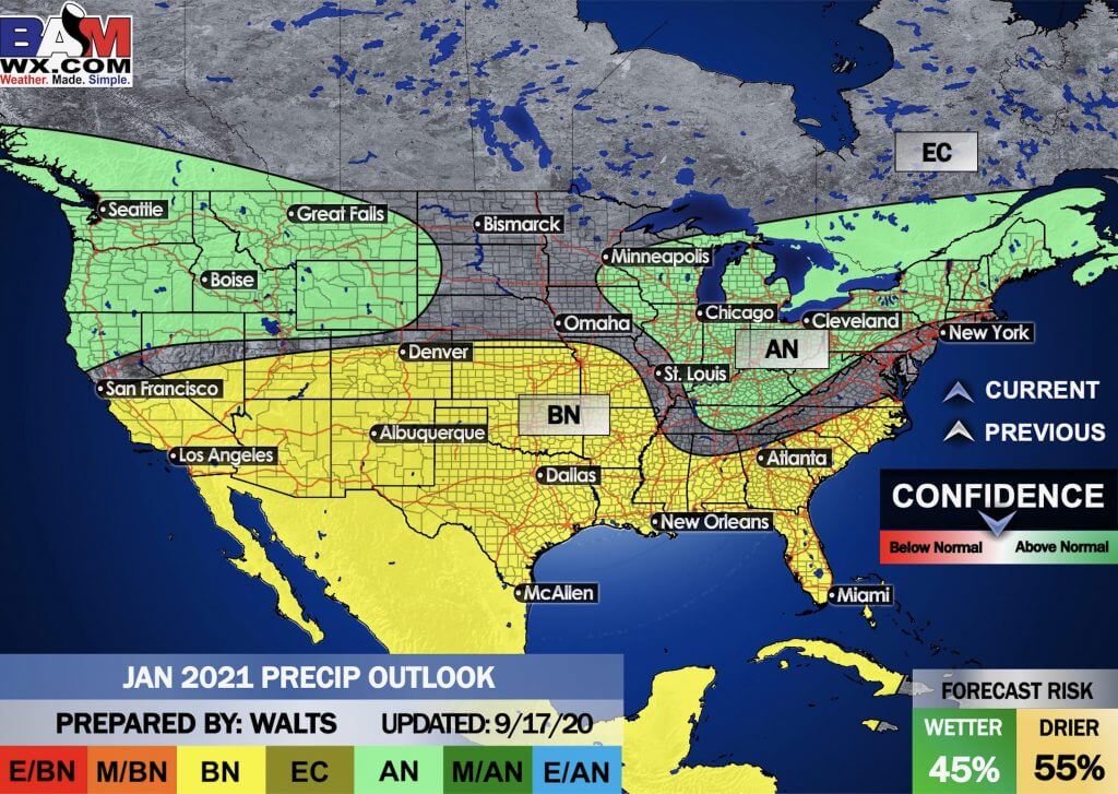
Precipitation outlook
LONG RANGE DISCUSSION
Key Points: This was written by the BAMwx team. I don’t edit it.
THIS WILL RETURN IN THE SPRING. DURING THE GROWING SEASON.
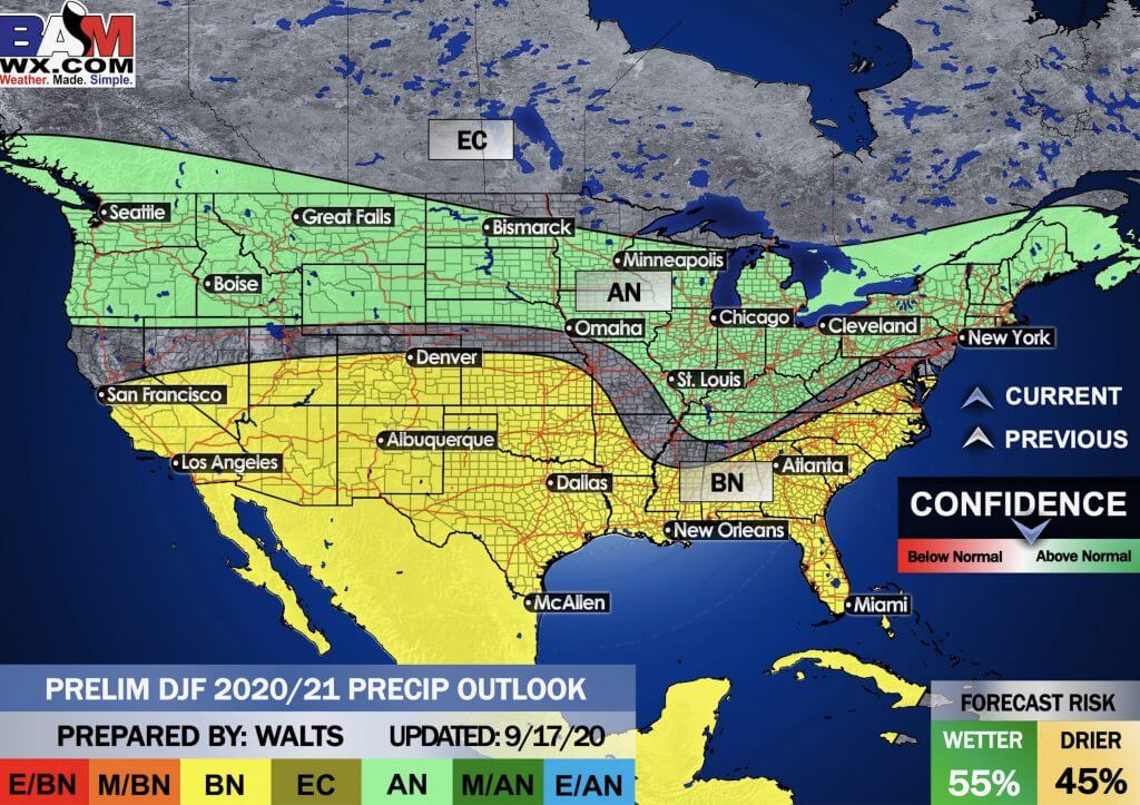
Winter Outlook
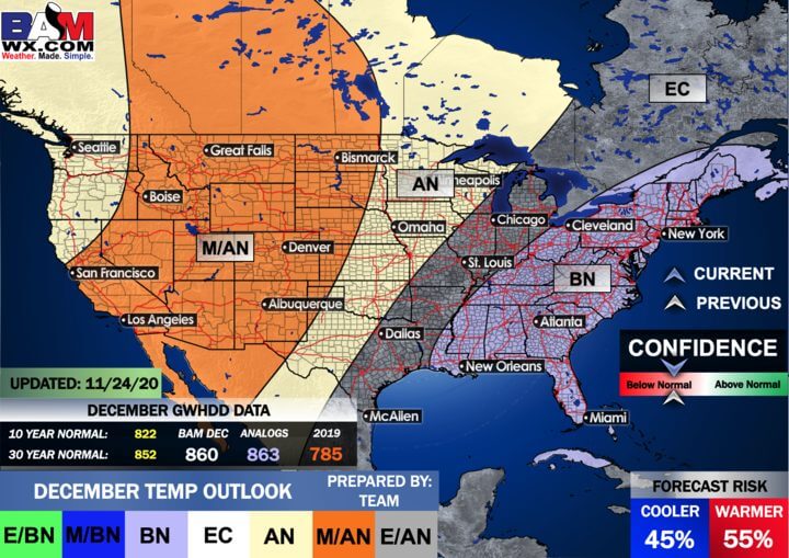
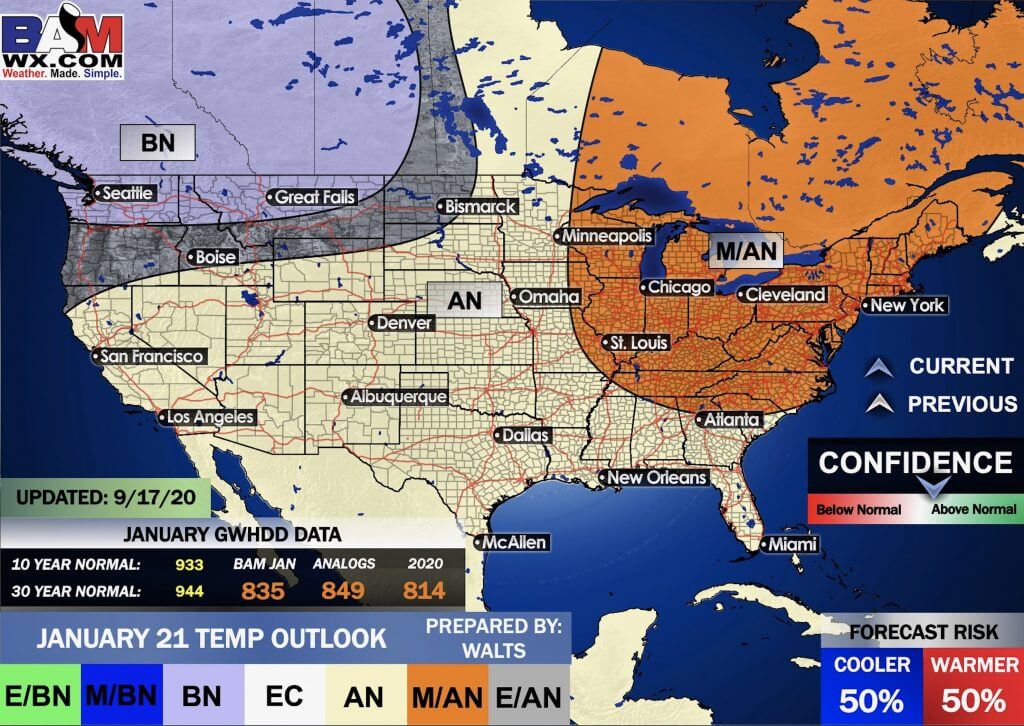
Click to enlarge it. Then, you can read it better.
December through February Temperature Outlook (preliminary)
December through February Precipitation Outlook (preliminary)
..
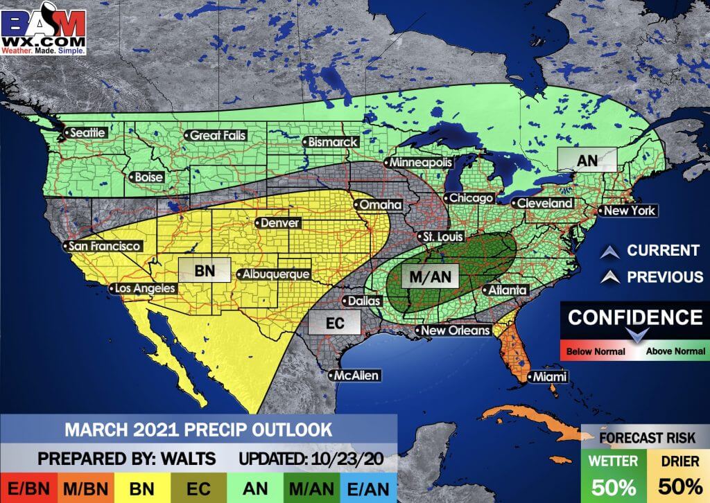
E/BN extremely below normal.
M/BN is much below normal
EC equal chances
AN above normal
M/AN much above normal
E/AN extremely above normal.
January Temperature Outlook (preliminary)
January Precipitation Outlook (preliminary)
.
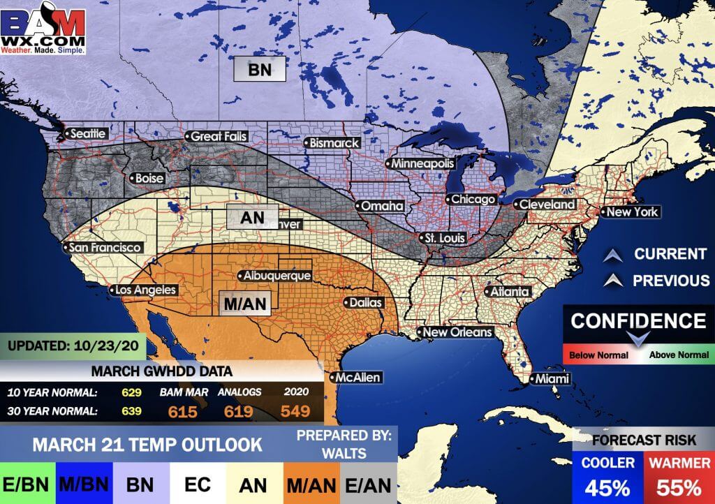
E/BN extremely below normal.
M/BN is much below normal
EC equal chances
AN above normal
M/AN much above normal
E/AN extremely above normal.
February Temperature Outlook (preliminary)
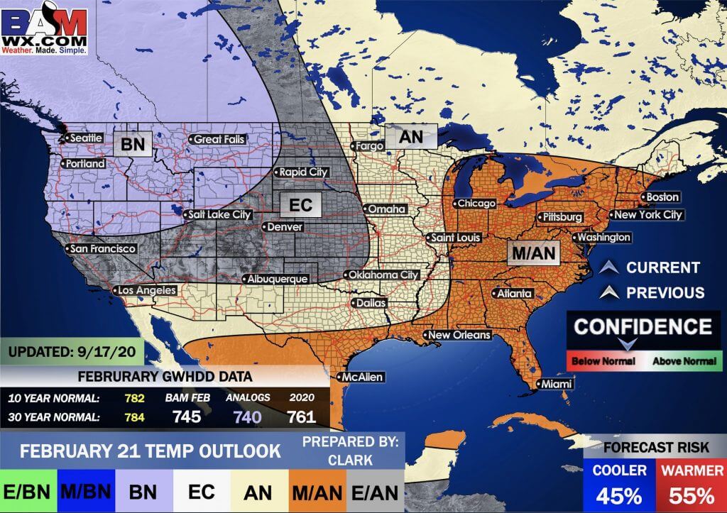
February Precipitation Outlook (preliminary)
.
And the preliminary March outlooks
Temperature departures
Precipitation
.
![]()

Great news! The videos are now found in your Weathertalk app and on the WeatherTalk website.
These are bonus videos for subscribers.
The app is for subscribers. Subscribe at www.weathertalk.com/welcome then go to your app store and search for WeatherTalk
Subscribers, PLEASE USE THE APP. ATT and Verizon are not reliable during severe weather. They are delaying text messages.
The app is under WeatherTalk in the app store.

Apple users click here

Android users click here
.

Radar Link: Interactive local city-view radars & regional radars.
You will find clickable warning and advisory buttons on the local city-view radars.
If the radar is not updating then try another one. If a radar does not appear to be refreshing then hit Ctrl F5. You may also try restarting your browser.
Not working? Email me at beaudodson@usawx.com
National map of weather watches and warnings. Click here.
Storm Prediction Center. Click here.
Weather Prediction Center. Click here.
.

Live lightning data: Click here.
.

Interactive GOES R satellite. Track clouds. Click here.
GOES 16 slider tool. Click here.
College of Dupage satellites. Click here
.

Here are the latest local river stage forecast numbers Click Here.
Here are the latest lake stage forecast numbers for Kentucky Lake and Lake Barkley Click Here.
.
.
Find Beau on Facebook! Click the banner.


 .
.