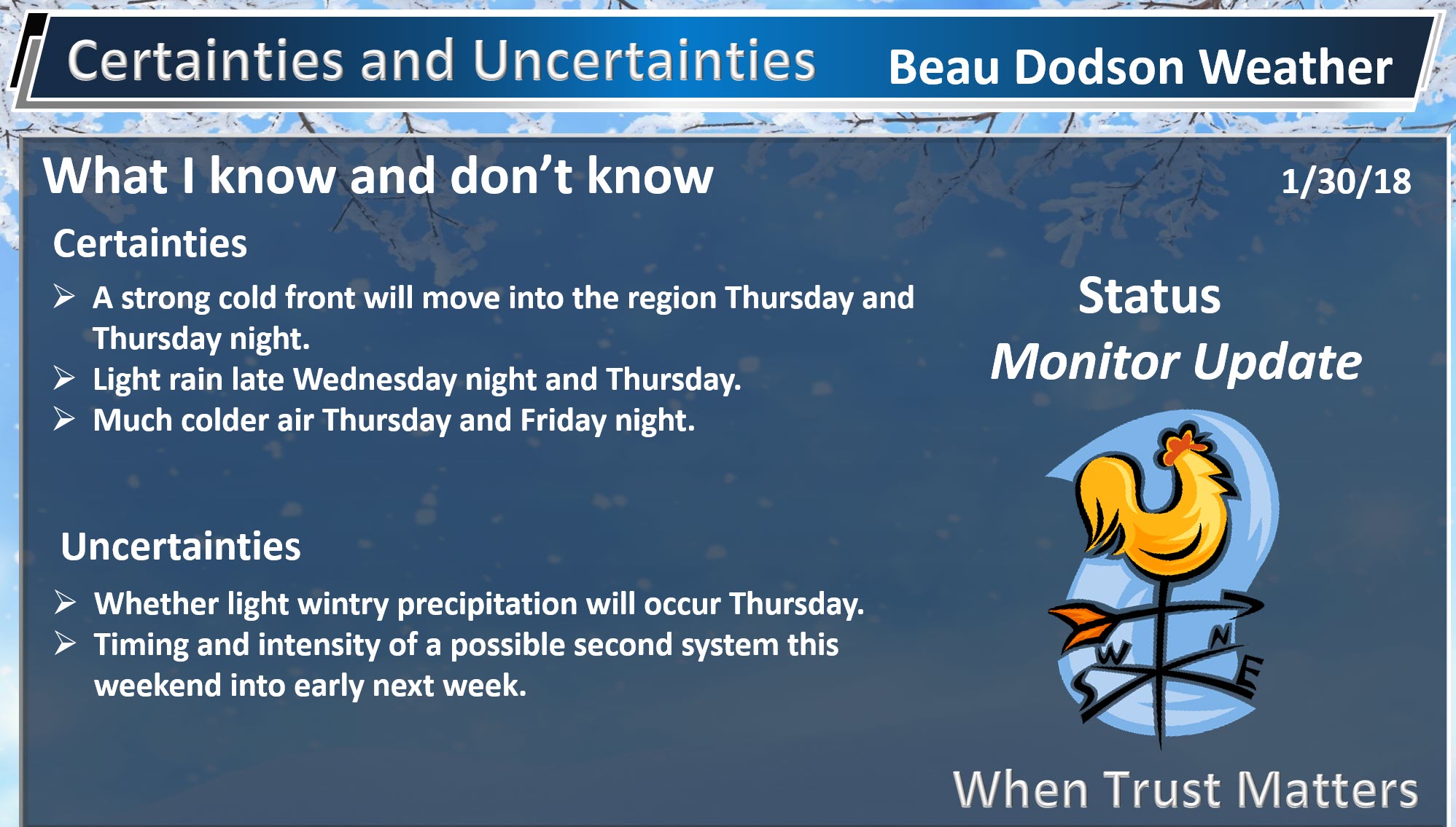
Afternoon update:
The daily forecast has also been updated (further down in the blog)
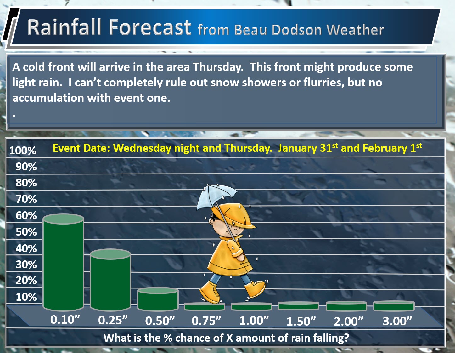
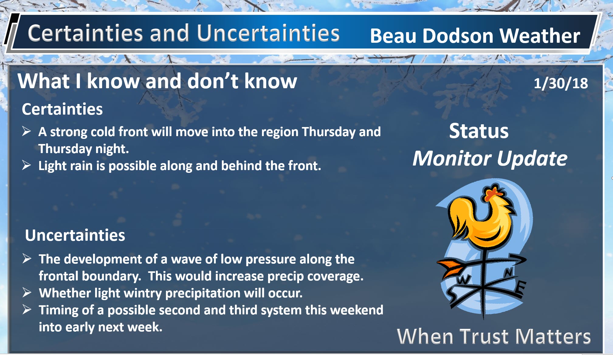
Today’s guidance has come into better agreement concerning our Wednesday night and Thursday event.
This will be a light rain event. Here is my rainfall prediction. What is the % chance of X amount of rain falling.
.
.
Rain may end as light snow or flurries. That would occur Thursday afternoon and evening. At this time, no accumulation anticipated.
The next item of interest will be rain/snow chances Saturday into Sunday.
Guidance is trending towards a bigger event. With that said, models have been horrible over the past week. They are not handling the fast jet stream flow. There are numerous disturbances moving through the flow.
I would not hang my hat on any particular model. I would simply monitor updates.
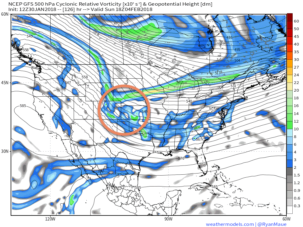
Guidance is trending towards the northern stream and southern stream merging. If this happens, then our snow chances will increase.
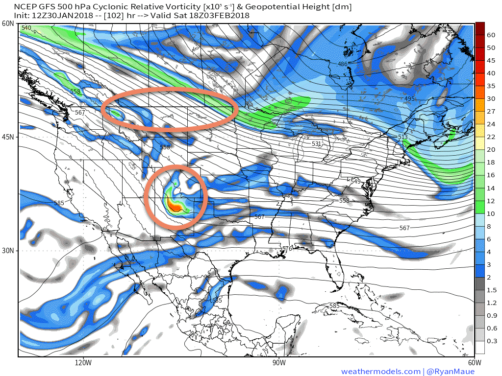
Here is the 500 mb vorticity chart. This chart shows you where disturbances in the atmosphere are located. These disturbances are what help product precipitation.
Want to learn more about 500 mb vorticity? Here you go (click here)
This is the chart 12 PM Saturday chart. See the two pieces of energy?
.
.
Here is the 12 PM Sunday map. They are merging.
.
.
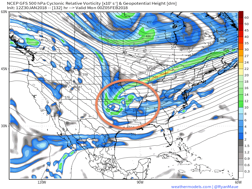
Here is the 6 PM Sunday map. This system needs to be monitored.
.
.
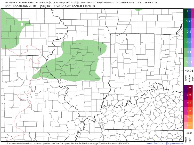
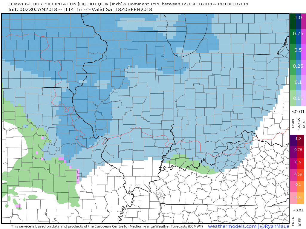
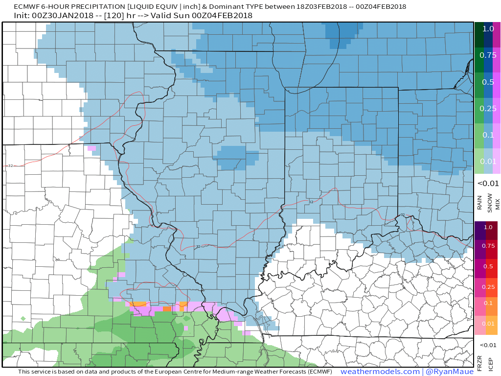
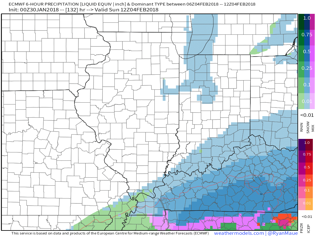
As far as precipitation maps. Let me show you the EC future-cast radar.
Green represents rain. Blue is snow. Other colors are a mixture. This chart shows you 3 hour precipitation totals.
Time stamp is zulu time. 12Z would be 6 AM. 18Z would be 12 PM. 0Z would be 6 PM. 6Z would be 12 AM.
The EC attempts to bring precipitation into our region Saturday afternoon into Sunday.
It is still a bit early to know whether this will be an accumulating snow.
.
.
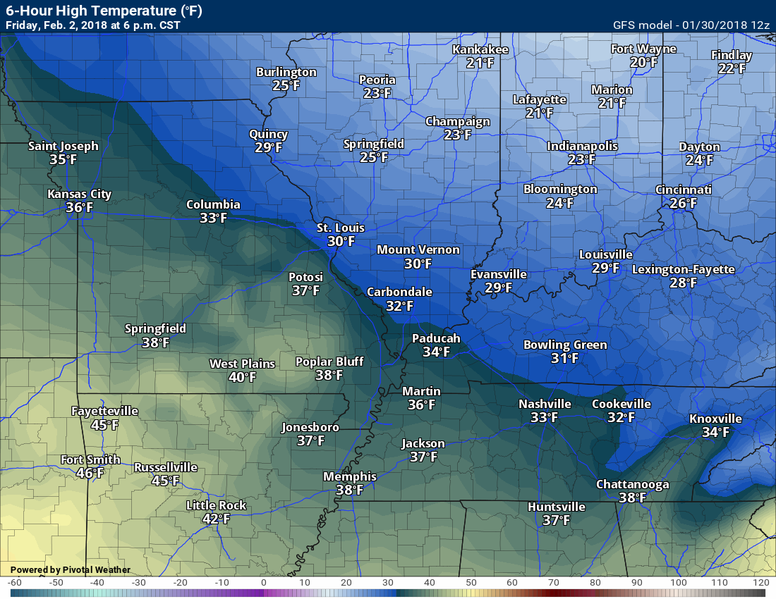
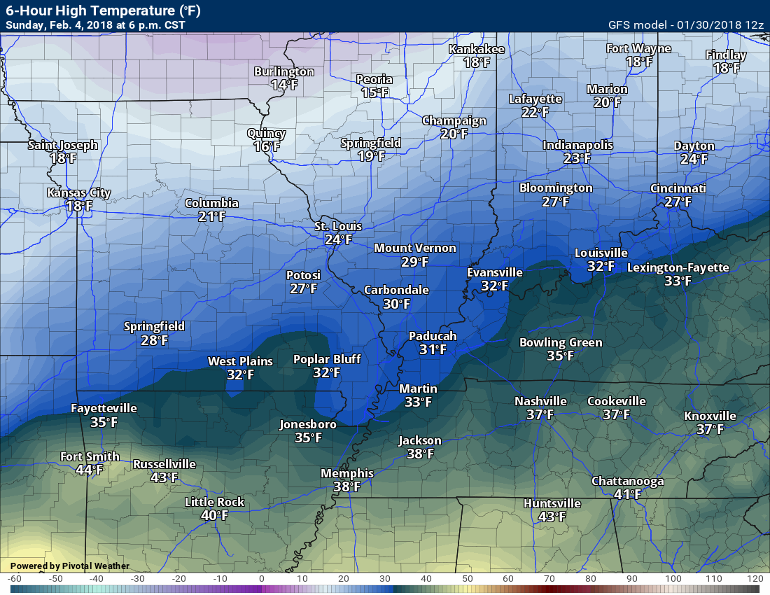
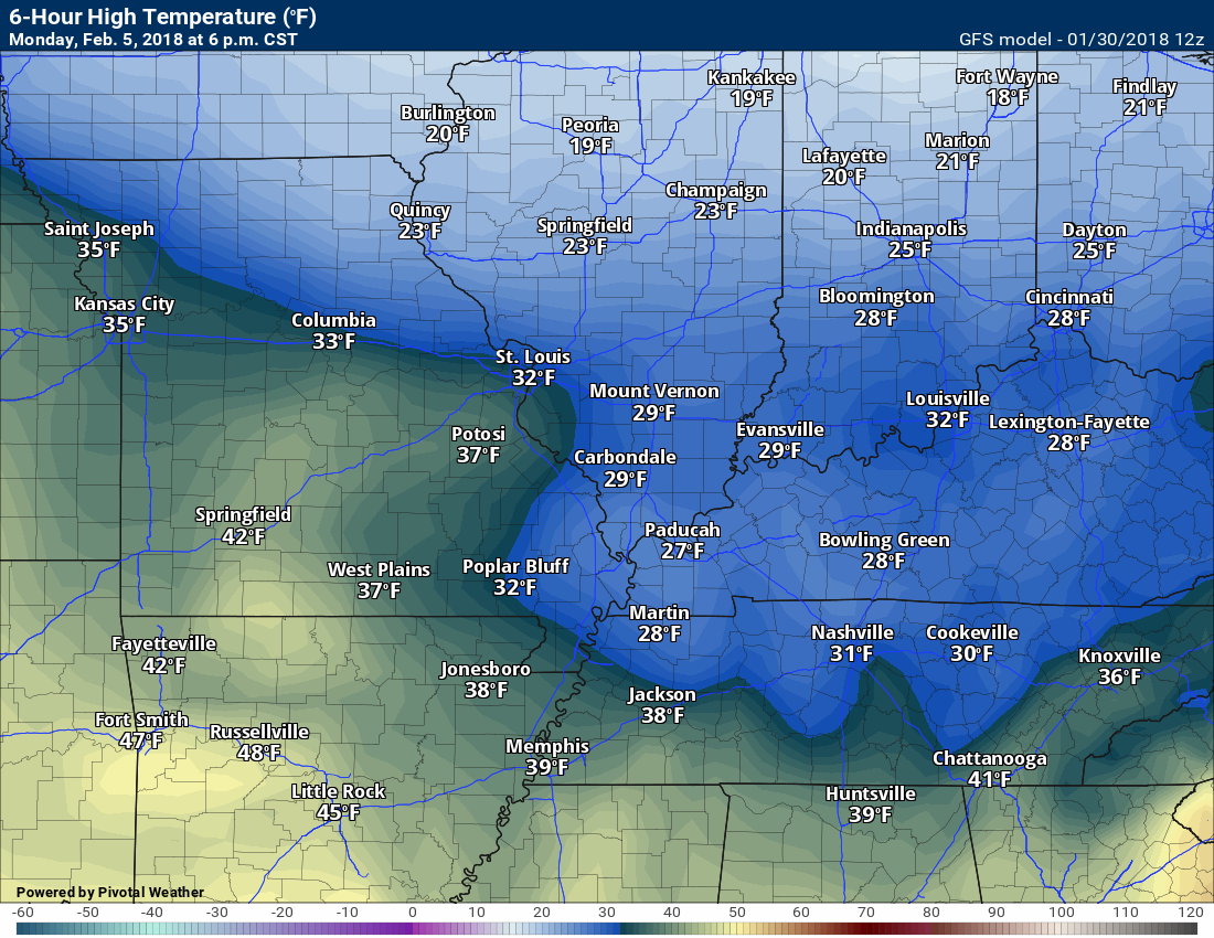
Plan on cold weather Friday into the weekend.
Temperatures will be highly dependent on snow cover. If we have snow, then temperatures will be quite a bit lower than shown on these maps.
Friday highs
.
Saturday highs
.

Sunday highs
.
Monday highs
.
.
Lows will be in the teens Thursday night, Friday night, Sunday night, and Monday night. Again, actual lows will depend on snow cover.
I have updated these graphics.
.

.
.

.
Previous update below
Monthly costs to run Weather Talk can top $2000.00
Please consider subscribing!
Here are my monthly out of pocket costs to deliver you the weather.
.

.
Do you want more? How about short and long range outlooks, videos, and more detailed analysis! You will receive that with your subscription.
Subscribe at www.beaudodsonweather.com
Once subscribed you can choose from four different app/text messages!
.
.
Subscriber videos and long range update – Click Here
.

.
January 30, 2018
Tuesday Forecast Details
Forecast: A mix of sun and clouds. Chilly. Some passing clouds through the day.
Temperatures: MO ~ 36 to 42 IL ~ 35 to 40 KY ~ 35 to 40
What is the chance of precipitation? MO ~ 0% IL ~ 0% KY ~ 0% TN ~ 0%
Coverage of precipitation: None
Wind chill values: 28 to 35
Accumulating snow or ice: No
Winds: North becoming south at 6 to 12 mph
What impacts are anticipated from the weather? None
My confidence in the forecast verifying: High
Is severe weather expected? No
The NWS defines severe weather as 58 mph wind or great, 1″ hail or larger, and/or tornadoes
Should I cancel my outdoor plans? No
Subscriber videos and long range update – Click Here
.
Tuesday Night Forecast Details:
Forecast: Mostly clear. Rising temperatures late tonight as southerly winds develop. Breezy, at times.
Temperatures: MO ~ 26 to 32 and then rising IL ~ 26 to 32 and then rising KY ~ 28 to 32 and then rising
What is the chance of precipitation? MO ~ 0% IL ~ 0% KY ~ 0% TN ~ 0%
Coverage of precipitation: None
Wind chill values: 20 to 30
Accumulating snow or ice: No
Winds: South at 5 to 10 mph becoming gusty overnight.
What impacts are anticipated from the weather? None
My confidence in the forecast verifying: High
Is severe weather expected? No
The NWS defines severe weather as 58 mph wind or great, 1″ hail or larger, and/or tornadoes
Should I cancel my outdoor plans: No
.
January 31, 2018
Wednesday Forecast Details
Forecast: Becoming windy. Mostly sunny during the morning. Some increase in clouds during the afternoon. Mild.
Temperatures: MO ~ 54 to 58 IL ~ 54 to 56 KY ~ 54 to 58
What is the chance of precipitation? MO ~ 0% IL ~ 0% KY ~ 0% TN ~ 0%
Coverage of precipitation: None
Wind chill values: N/A
Accumulating snow or ice: No
Winds: South at 15 to 30 mph with gusts above 30 mph likely
What impacts are anticipated from the weather? None
My confidence in the forecast verifying: High
Is severe weather expected? No
The NWS defines severe weather as 58 mph wind or great, 1″ hail or larger, and/or tornadoes
Should I cancel my outdoor plans? No
.
Wednesday Night Forecast Details:
Forecast: Becoming cloudy. A chance of mainly late night rain showers. Cool.
Temperatures: MO ~ 40 to 44 IL ~ 38 to 44 KY ~ 40 to 44
What is the chance of precipitation? MO ~ 40% IL ~ 40% KY ~ 40% TN ~ 30%
Coverage of precipitation: Scattered
Wind chill values: 30 to 40
Accumulating snow or ice: No
Winds: South becoming southwest at 6 to 12 mph
What impacts are anticipated from the weather? Wet roadways
My confidence in the forecast verifying: High
Is severe weather expected? No
The NWS defines severe weather as 58 mph wind or great, 1″ hail or larger, and/or tornadoes
Should I cancel my outdoor plans: No
.
The Thursday through Monday part of the forecast remains in the LOW to medium confidence category. Monitor updates.
February 1, 2018
Thursday Forecast Details
Forecast: Mostly cloudy. Scattered rain showers. Temperatures may turn colder as the cold front pushes further south. Rain may briefly change to snow showers or flurries. Most likely no accumulation.
Temperatures: MO ~ 42 to 46 Temps may fall during the day IL ~ 44 to 48 temps may fall during the day KY ~ 45 to 50
What is the chance of precipitation? MO ~ 30% IL ~ 40% KY ~ 60% TN ~ 60%
Coverage of precipitation: Scattered to perhaps a band of precipitation moving through the area. Best chance of rain may end up over Kentucky and Tennessee.
Wind chill values: 35 to 45
Accumulating snow or ice: Unlikely.
Winds: West at 8 to 16 mph and gusty. Winds becoming north and northwest behind the cold front (northern portions of the area).
What impacts are anticipated from the weather? Wet roadways. Monitor updates.
My confidence in the forecast verifying: Medium
Is severe weather expected? No
The NWS defines severe weather as 58 mph wind or great, 1″ hail or larger, and/or tornadoes
Should I cancel my outdoor plans? Have a plan B
.
Thursday Night Forecast Details:
Forecast: Cloudy early. Light flurries or snow showers possible. Clearing and colder overnight. Breezy.
Temperatures: MO ~ 16 to 22 IL ~ 16 to 22 KY ~ 16 to 28
What is the chance of precipitation? MO ~ 20% IL ~ 20% KY ~ 20% TN ~ 20%
Coverage of precipitation: Ending.
Wind chill values: 5 to 15
Accumulating snow or ice: Most likely no, but monitor updates.
Winds: Becoming north and northwest at 10 to 20 mph. Gusty winds.
What impacts are anticipated from the weather? Monitor updates
My confidence in the forecast verifying: Medium
Is severe weather expected? No
The NWS defines severe weather as 58 mph wind or great, 1″ hail or larger, and/or tornadoes
Should I cancel my outdoor plans: No, but monitor updates.
.
February 2, 2018
Friday Forecast Details
Forecast: Mostly sunny. A few passing clouds. Colder.
Temperatures: MO ~ 28 to 34 IL ~ 28 to 34 KY ~ 28 to 34
What is the chance of precipitation? MO ~ 10% IL ~ 10% KY ~ 10% TN ~ 10%
Coverage of precipitation: Most likely none
Wind chill values: 20 to 30
Accumulating snow or ice: No
Winds: North and northwest at 5 to 10 mph
What impacts are anticipated from the weather? None
My confidence in the forecast verifying: High
Is severe weather expected? No
The NWS defines severe weather as 58 mph wind or great, 1″ hail or larger, and/or tornadoes
Should I cancel my outdoor plans? No
.
Friday Night Forecast Details:
Forecast: Mostly clear early and then increasing clouds. A slight chance of snow showers after 3 AM. Colder
Temperatures: MO ~ 18 to 22 IL ~ 18 to 22 KY ~ 18 to 22
What is the chance of precipitation? MO ~ 20% IL ~ 20% KY ~ 20% TN ~ 20%
Coverage of precipitation: Scattered late
Wind chill values: 10 to 20
Accumulating snow or ice: Unlikely, but monitor updates
Winds: South at 6 to 12 mph
What impacts are anticipated from the weather? Most likely none.
My confidence in the forecast verifying: LOW
Is severe weather expected? No
The NWS defines severe weather as 58 mph wind or great, 1″ hail or larger, and/or tornadoes
Should I cancel my outdoor plans: No
.
February 3, 2018
Saturday Forecast Details
Forecast: Increasing clouds. A chance of scattered rain or snow showers across southeast Missouri after 12 PM. Lesser chances elsewhere.
Temperatures: MO ~ 38 to 44 IL ~ 38 to 44 KY ~ 38 to 44
What is the chance of precipitation? MO ~ 30% IL ~ 20% KY ~ 20% TN ~ 20%
Coverage of precipitation: Perhaps scattered, but confidence is low.
Wind chill values: 30 to 40
Accumulating snow or ice: Monitor updates
Winds: South at 10 to 20 mph and gusty
What impacts are anticipated from the weather? None
My confidence in the forecast verifying: Medium
Is severe weather expected? No
The NWS defines severe weather as 58 mph wind or great, 1″ hail or larger, and/or tornadoes
Should I cancel my outdoor plans? No
.
Saturday Night Forecast Details:
Forecast: Mostly cloudy. Rain or snow showers changing to snow.
Temperatures: MO ~ 28 to 34 IL ~ 28 to 34 KY ~ 28 to 34
What is the chance of precipitation? MO ~ 30% IL ~ 30% KY ~ 30% TN ~ 30%
Coverage of precipitation: Scattered
Wind chill values: 20 to 30
Accumulating snow or ice: Monitor updates
Winds: South 7 to 14 mph with gusts to 20 mph
What impacts are anticipated from the weather? Monitor updates
My confidence in the forecast verifying: LOW
Is severe weather expected? No
The NWS defines severe weather as 58 mph wind or great, 1″ hail or larger, and/or tornadoes
Should I cancel my outdoor plans: Monitor updates
.
February 4, 2018
Sunday Forecast Details
Forecast: Morning clouds and snow showers possible. Partly sunny during the afternoon.
Temperatures: MO ~ 30 to 35 IL ~ 30 to 35 KY ~ 30 to 35
What is the chance of precipitation? MO ~ 30% IL ~ 30% KY ~ 30% TN ~ 30%
Coverage of precipitation: Scattered
Wind chill values: 20 to 30
Accumulating snow or ice: Monitor updates
Winds: North at 7 to 14 mph with gusts to 20 mph
What impacts are anticipated from the weather? Monitor updates
My confidence in the forecast verifying: LOW
Is severe weather expected? No
The NWS defines severe weather as 58 mph wind or great, 1″ hail or larger, and/or tornadoes
Should I cancel my outdoor plans? Monitor updates
.
Sunday Night Forecast Details:
Forecast: A chance of snow showers. Cold.
Temperatures: MO ~ 15 to 20 IL ~ 15 to 20 KY ~ 15 to 20
What is the chance of precipitation? MO ~ 30% IL ~ 30% KY ~ 30% TN ~ 30%
Coverage of precipitation: Scattered
Wind chill values: 8 to 16
Accumulating snow or ice: Monitor updates
Winds: North 7 to 14 mph with gusty winds possible
What impacts are anticipated from the weather? Monitor updates
My confidence in the forecast verifying: LOW
Is severe weather expected? No
The NWS defines severe weather as 58 mph wind or great, 1″ hail or larger, and/or tornadoes
Should I cancel my outdoor plans: Monitor updates
.
February 5, 2018
Monday Forecast Details
Forecast: Partly cloudy. Snow showers possible. Cold.
Temperatures: MO ~ 26 to 30 IL ~ 26 to 32 KY ~ 26 to 32
What is the chance of precipitation? MO ~ 20% IL ~ 20% KY ~ 20% TN ~ 20%
Coverage of precipitation:
Wind chill values: 15 to 25
Accumulating snow or ice: Monitor updates
Winds: North 6 to 12 mph
What impacts are anticipated from the weather? Monitor updates
My confidence in the forecast verifying: LOW
Is severe weather expected? No
The NWS defines severe weather as 58 mph wind or great, 1″ hail or larger, and/or tornadoes
Should I cancel my outdoor plans? Monitor updates
.
Monday Night Forecast Details:
Forecast: Mostly clear early. Increasing clouds after midnight. Cold.
Temperatures: MO ~ 16 to 22 IL ~ 16 to 22 KY ~ 18 to 22
What is the chance of precipitation? MO ~ 0% IL ~ 0% KY ~ 0% TN ~ 0%
Coverage of precipitation: None
Wind chill values: 0 to 15
Accumulating snow or ice:
Winds: North 5 to 10 with gusts to 12 mph
What impacts are anticipated from the weather? Monitor updates
My confidence in the forecast verifying: Medium
Is severe weather expected? No
The NWS defines severe weather as 58 mph wind or great, 1″ hail or larger, and/or tornadoes
Should I cancel my outdoor plans: Monitor updates
.

.
Tuesday through Wednesday afternoon: No snow or ice through Wednesday night.
Light snow or flurries will be possible Thursday afternoon and evening. Confidence on accumulation remains low. This appears to be a light event with little or no accumulation. Monitor updates.
Another chance of snow arrives Saturday into Sunday night. Another chance early next week. Monitor updates, as always. The pattern is active.
.

.
The National Weather Service definition of a severe thunderstorm is one that produces quarter size hail or larger, 58 mph winds or greater, and/or a tornado.
Now through next Wednesday: No severe weather concerns.
.

.
January 30, 2018
The daily outlook can be found at the bottom of this post.
Forecast
Interactive Weather Radar Page. Choose the city nearest your location: Click this link.
High confidence in the 36 hour forecast.
Temperatures will remain chilly today. Most areas will top out in the 30’s, again. Mostly sunny. A few intervals of clouds possible this afternoon.
Temperatures tonight will bottom out early and then rise as southerly winds develop.
The good news is that Wednesday will be milder! Highs should top out in the 50’s! Winds will increase into the 20 to 30 mph range on Wednesday, as well.
Milder, but windy.
It will remain dry today through Wednesday afternoon.
Wednesday night into Friday:
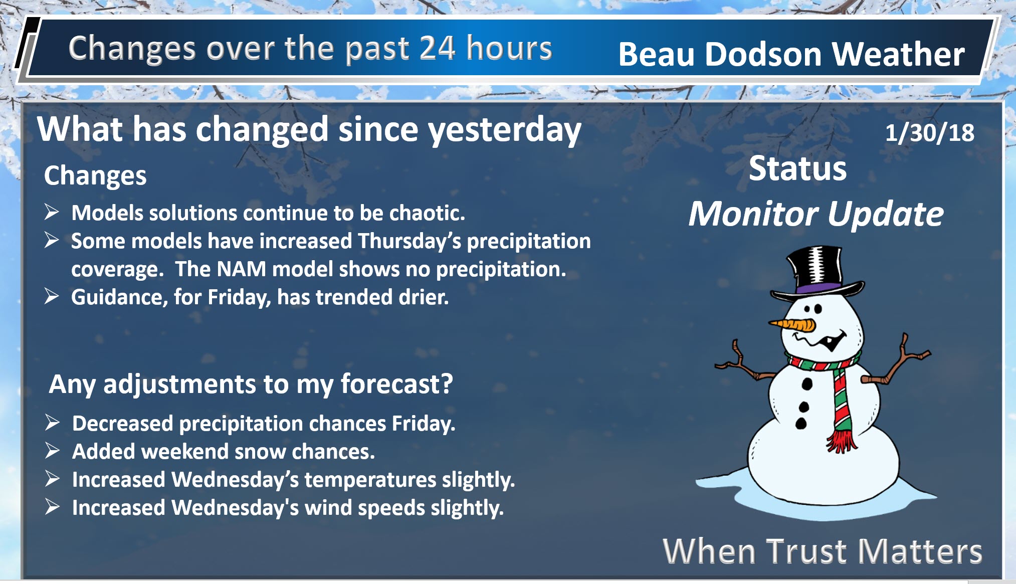
Low to medium confidence (confidence is increasing in the outcome of this event)
I have adjusted my forecast to account for somewhat higher confidence.
As is typical during the winter months, the long range outlook is complicated.
Models, over the past week, have been of little use. They have shown wild swings. At times the GFS model will show 10″ of snow. At times the GFS model will show no rain or snow, at all. Other models have been similar.
A cold front will enter our region Wednesday night and Thursday. This front will produce a few showers ahead of it. The bulk of the precipitation, however, is forecast to fall behind the front.
How much moisture remains behind the front is questionable (especially as the colder air arrives). It appears the cold air will arrive fast enough to help dry the atmosphere out. Thus, if rain does change to snow, it would be for a brief period of time.
I continue to feel confident that we will have precipitation falling from the sky late Wednesday night into perhaps Thursday night. I feel confident that rain will occur. The snow portion of the forecast remains uncertain, at best.
I have been telling people that we may not have a complete handle on the forecast until Tuesday night and Wednesday. That thought remains unchanged.
I will continue to monitor trends in the guidance and update accordingly.
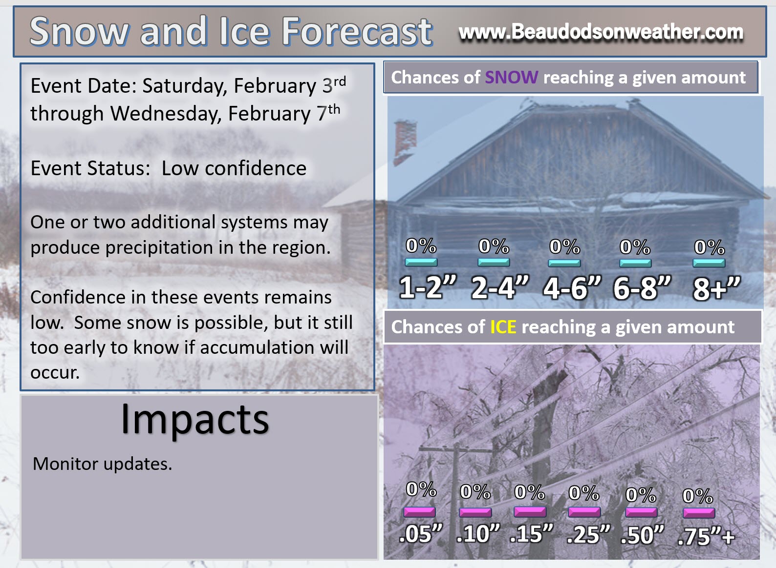
To complicate the forecast further, a second cold front is possible over the weekend. This front could also produce precipitation. Confidence is low on the the eventual outcome of that front, as well. I am monitoring Saturday night into Sunday night.
Best advice, monitor updated forecasts.
This is an active pattern. There will be several precipitation chances over the next 14 days. There will also be quite a bit of cold air available. There is an above normal chance for wintry precipitation in February.
Remember, potential does not always make reality. It takes all of the weather ingredients coming together, just right, in order for our region to have a winter weather event.
Late Friday night into Saturday night:
Low confidence
Another fast moving system is forecast to push through the region late Friday night into Saturday. There is quite a bit of debate about how much moisture will be available for this system. To complicate matters even further, there is the possibility of a wave of low pressure developing to our south and southeast. If that were to happen then snow chances would increase.
Here was the overnight EC model guidance concerning that event.
The EC is faster than other models. The models are having a difficult time resolving how the next seven days unfold. I would suggest checking back for updated information.
Here is the 12 PM Saturday EC six hour precipitation map.
These are six hour precipitation totals. Green is rain. Blue is snow. Scale is on the right side of the image.
.
.
Here is the 12 PM to 6 PM totals
.
.
Here are the 6 PM Saturday until 12 AM Sunday precipitation totals (notice a wave of low pressure forms along the front to our south). That would enhance snow. Whether this happens or not is still highly questionable.
.

.
Here is the 12 AM Sunday to 6 AM Sunday precipitation totals.
.
.
Those totals added together would produce this map.
Will this happen? It is too soon to know.
Click images to enlarge
.

.
The GFS model also shows some snow potential. Confidence is low.
.
.
I will monitor trends and update accordingly.
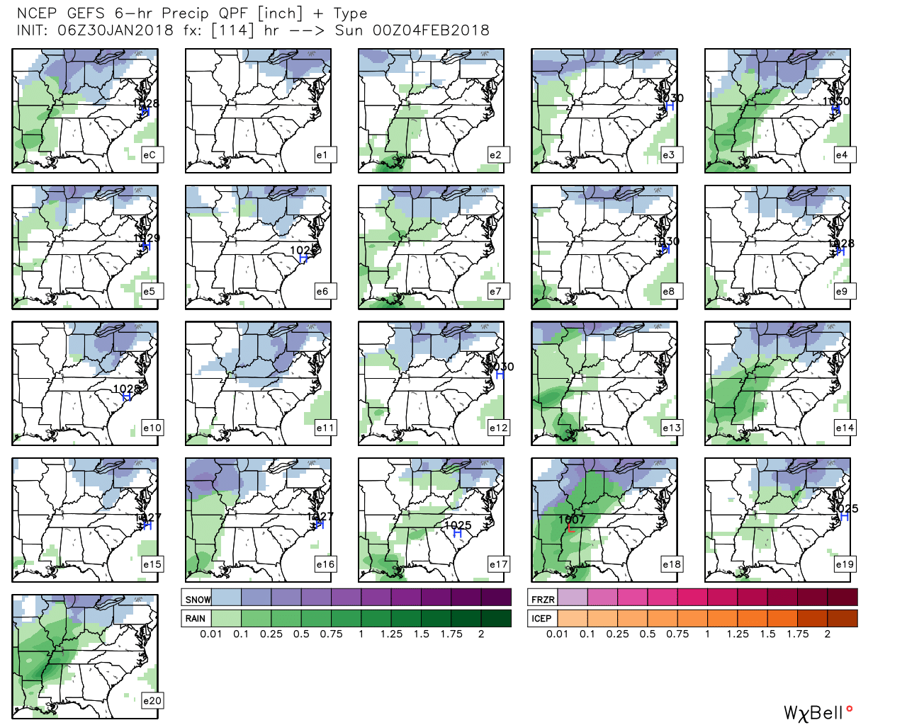
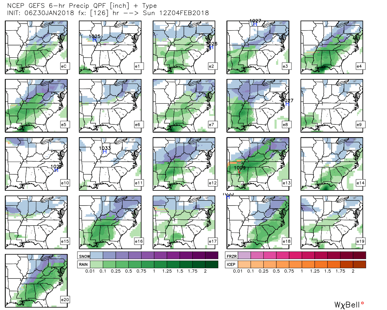
The ensembles are showing mixed ideas on the Saturday into Sunday event.
Here are the GEFS ensemble graphics. These are six hour precipitation totals from 12 PM Saturday until 6 PM Saturday.
You can see that some of the panels show rain or rain/snow and others are dry. This will need monitoring.
.
.
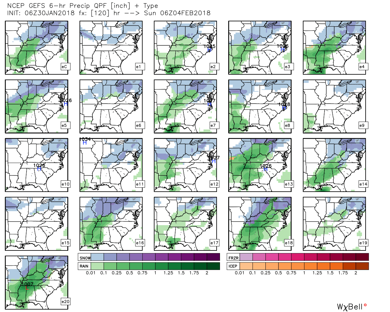
6 PM Saturday through 12 AM Sunday. Six hour precipitation totals. Again, mixed ideas on how this unfolds.
.
.
12 AM to 6 AM Sunday. Six hour precipitation totals.
.
.

.
.
.
Here is my first forecast concerning the February 1st and 2nd event.
.

.
I would not be surprised to see some snow accumulation this weekend, but confidence still remains low. I hope to add probability numbers tomorrow night.
.
.


We offer regional radars and local city radars – if a radar does not update then try another one. Occasional browsers need their cache cleared. You may also try restarting your browser. This will usually fix any problems.
During the winter you can track snow and ice by clicking the winterize button on the local city view interactive radars.
You may email me at beaudodson@usawx.com
Interactive Weather Radar Page. Choose the city nearest your location: Click this link
National interactive radar: Click this link.