
11 AM Update
All signs point to this being a rain event for my forecast counties. Maybe it will end as flurries or light snow on Sunday night.
We have our first sponsor for the blog. Milner and Orr Funeral Home and Cremation Services located in Paducah, Kentucky and three other western Kentucky towns – at Milner and Orr they believe in families helping families.
![]()

This forecast update covers far southern Illinois, far southeast Missouri, and far western Kentucky. See the coverage map on the right side of the blog.
Remember that weather evolves. Check back frequently for updates, especially during active weather.
Our weekend system will be coming into view over the coming 24-48 hours. NEW data will arrive today. The storm itself won’t be properly sampled by the models until today. That means there are going to be shifts and wavers in the data output.
Check back for updates – I will post little updates at the top of the page.
A lengthy update tonight, of course. I will also post updates on the Beau Dodson Facebook page.
Friday – We should have quite a few clouds at the start of the day and then perhaps some partly cloudy sky conditions by afternoon. Temperatures will be chilly and below normal. Highs in the 30’s. Confidence is high in this part of the forecast.
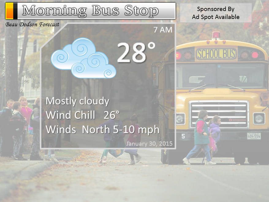
Morning School Bus Stop Weather – Mostly cloudy and cold. Temperatures at the morning bus stop will be in the upper 20’s and lower 30’s. Light winds. Chances of schools being delayed because of the weather? 0%
—————————————————————————————-
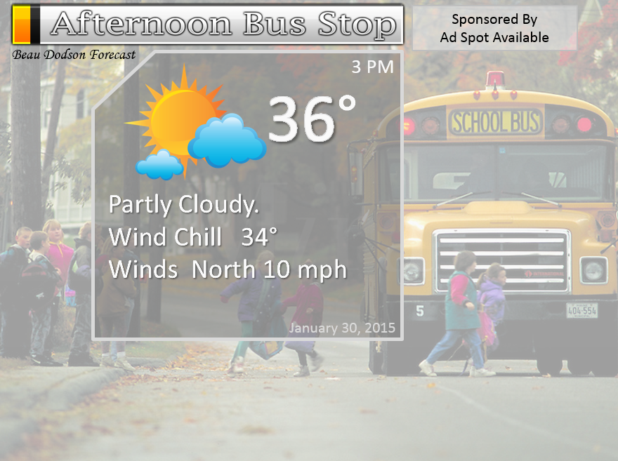
Afternoon School Bus Stop Weather – Partly sunny and cold. Temperatures in the 30’s. Light winds around 5-10 mph.
Friday night – Mostly clear and cold. Lows from 18 to 24 degrees. Northeast winds shifting southeast at 5-10 mph. Confidence is high in this part of the forecast.
Saturday – Increasing and thickening clouds through the day. A chance for some afternoon light rain or showers. Chilly. High temperatures will be in the upper 30’s to lower 40’s. South winds at 5-10 mph. Confidence is high in this part of the forecast.
Saturday night – Cloudy. Widespread precipitation developing from west to east – especially late. Precipitation will begin first over our northwest counties and spread eastward. Rain will be the most likely precipitation type for the counties I forecast for. See my county forecast map on the right hand side of the page. Low temperatures will be in the 30’s. Southeast/east winds at 5-10 mph. The bulk of the precipitation will likely fall on Sunday. Confidence is medium in this part of the forecast.
Sunday – Rain likely. Some moderate downpours possible. Turning cold late in the day. Rain may change to snow. Temperatures falling into the upper 20’s during the afternoon over northern parts of southern Illinois and falling into the 30’s over western Kentucky – late in the day. Winds shifting to the northwest at 5-15 mph. Confidence is LOW in this part of the forecast.

Current Temperatures Around The Local Area

Friday’s Bus Stop Forecast

An explanation of what is happening in the atmosphere over the coming days…
A calm weather day is on tap for the region. One of many calm days this month. It will be colder today with highs mostly in the 30’s. Coat weather.
Tonight will be calm and cold. Expect temperatures to dip into the upper teens over a few of our counties and 20’s elsewhere. Saturday morning will be chilly. Light winds – wind chills will not be much of an issue.
The weekend precipitation maker…
There remain many questions concerning how this weekend precipitation maker unfolds. Now, I know there are already snowfall maps being tossed around. But, what do I always tell you about that subject? It is WAY too soon to be talking about snow accumulations.
The storm track is not set in stone. The system has not fully been sampled by the computer models. It will be today. That means that the models are spitting out scenarios that may not verify.
What I am confident about…
1. Precipitation arrives late on Saturday. Afternoon will probably bring some showers
2. Precipitation chances increase dramatically by late late Saturday night and Sunday morning. Mostly rain at first.
3. Rain continues on Sunday. Rain may turn to snow – especially over southern Illinois.
What I am not confident about…
1. Timing of rain changing to snow (or for how long it would even snow if the rain does change to snow)
2. Surface temperatures on Sunday during most of the precipitation event. They should be marginal for snow over northern parts of the area. Further south in Kentucky should be too warm for snow early on. Whether it cools down late in the day for snow is questionable.
3. Whether the rain changes to snow soon enough to allow any accumulation.
I am hoping to gather all of the data later this afternoon and tonight and put together a sensible/accurate forecast for you.
If you have travel plans on Saturday night into Sunday night then you will want to check back for updates. There could be some travel issues as you go north in our area. Whether that occurs over my forecast counties is still uncertain.
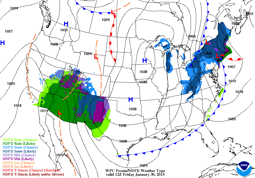
Here is the morning weather map – you can see our developing weekend system over the southwest United States. Another piece of energy will dive down from Canada and interact with our southwest storm. The main system, however, is the one centered over the southwest.
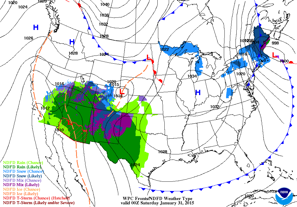
Friday evening’s weather map – our storm draws a little bit closer.
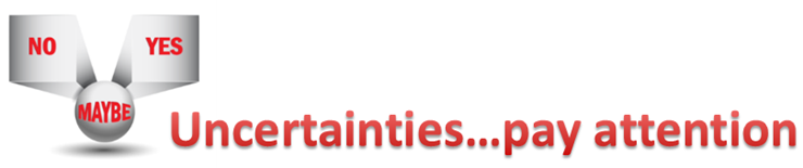
The uncertainties part of the e-journal spells out where I am not confident in the forecast. I always tell people to pay attention to the whole forecast and not just the part they want to hear.
Weather is rarely yes or no. Weather forecasts are made up of probabilities. If someone tells you that it is going to snow 1.7 inches in your backyard then I am not sure you should trust their forecast. Why? Because meteorology has not come that far. Not yet, anyway. I can tell you that you should receive 1″-3″ of snow. Yes. I can do that. I can not tell you that your backyard will receive 1.7 inches of snow. Sorry, if you are looking for that forecast then look elsewhere.
Uncertainties in today’s update – The uncertainties center around what happens on Saturday night into Sunday. I caution you that any snowfall forecast maps that you see posted online, Facebook, Twitter, or elsewhere should be taken with a grain of salt. It is still too early to be forecasting snowfall accumulations with this system. That is even assuming your county ends up with snow. That is not even a given at this point.
WANT TO SUPPORT THIS BLOG AND HELP COVER EXPENSES?
Did you know that the Weather Observatory is funded by people like you? I rely on ad’s on this blog and individual donations. PayPal also allows you to set up a monthly recurring donation. I have had several people give $5, $10, and $20 a month. A recurring donation helps keep the weather information flowing. If you enjoy this blog, the Twitter account, the Facebook interaction, the weather radars, and all of the other information then consider making a donation or setting up a recurring donation (if you don’t use PayPal then contact me through email about how you can mail a donation) beaudodson@usawx.com
Or mail me at
Beau Dodson
3954 Mermet Road
Belknap, IL
62908
Thank you for your support!

Changes in the forecast will likely occur over the next 24 hours. Confidence is fairly low as to how Sunday unfolds.

The weekend winter storm. Anyone with travel plans Saturday into Sunday/Monday should monitor updates. This is especially true as you move northward in our region.
Check out our newest sponsors $5 meal! The DQ Grill and Chill (located across from Noble Park in Paducah, Kentucky) is the newest WeatherTalk Blog sponsor! A local business helping to sponsor the weather information that you have come to love so much.
They have a Facebook Page and I encourage you to check it out. DQ Grill and Chill on Facebook


The wild card tells you where the uncertainties are in the forecast
Wild card in this forecast – the wild card in the forecast will center around our weekend storm system. Where to place that good ole rain/snow line. Best snow chances will likely be over our northern counties. Still a lot of questions.

Can we expect severe thunderstorms over the next 24 to 48 hours? Remember that a severe thunderstorm is defined as a thunderstorm that produces 58 mph winds or higher, quarter size hail or larger, and/or a tornado.
Thunderstorm threat level is ZERO


Will I need to take action?
Yes. Monitor the latest winter storm updates. If you have travel plans then you will want to check back.

How much precipitation should we expect over the next few days?
Precipitation chances start to increase on Saturday afternoon and especially on Saturday night and Sunday. Widespread precipitation will overspread our region on Saturday night into Sunday afternoon.
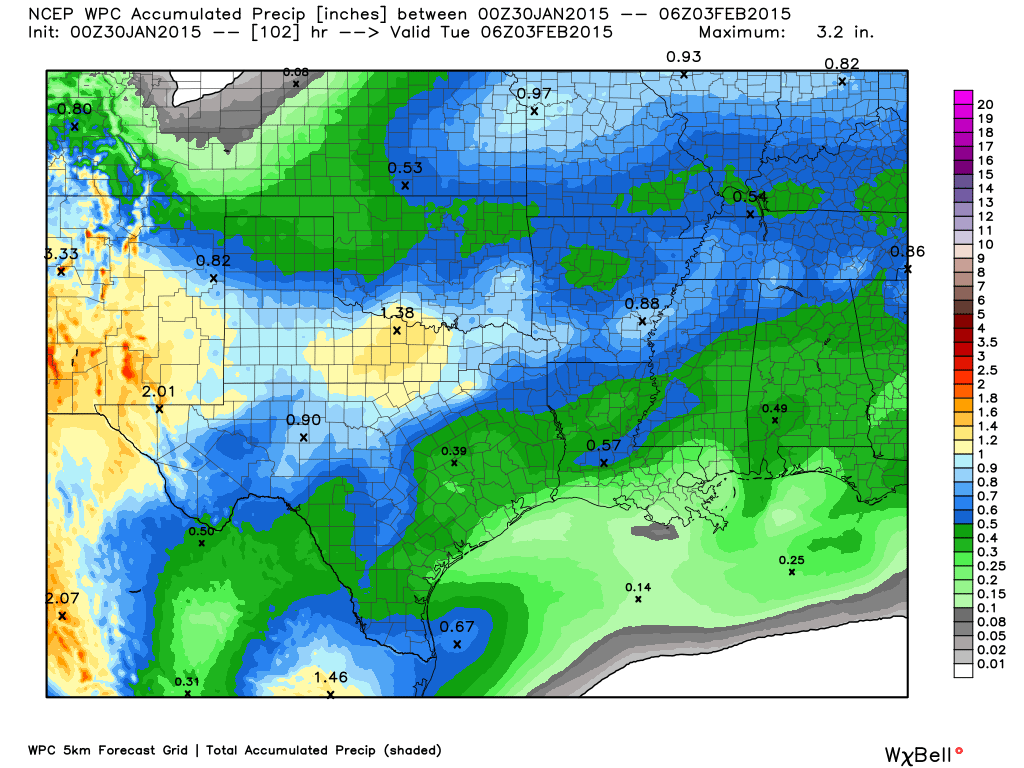
Here is the latest precipitation forecast – totals. You can see we have been painted in 0.40″-0.70″
Much needed precipitation. Most of that will fall on Sunday.
We have a new sponsor! G&C Multi-Services out of Paducah, Kentucky. G & C Multi-Services is a service provider in Western Kentucky that provides industrial and commercial equipment fabrication, machine troubleshooting, repair and maintenance, and installation. They can custom fabricate steel, stainless, and aluminum products per customer specifications.
Visit their web-site here. Or click the ad below! They have a Facebook page and it can be viewed here.


No winter weather in the forecast today.
I am watching for the possibility of some rain and snow this weekend. All of that was covered at the top of the blog (since it is in the short range).
Lot of questions remain. Stay tuned for updates as new data becomes available.

This section of the blog is speculative forecast information. Because it is past the range of what meteorologists can forecast accurately, it should be considered speculation. Anything past day 5 is considered a long range forecast.
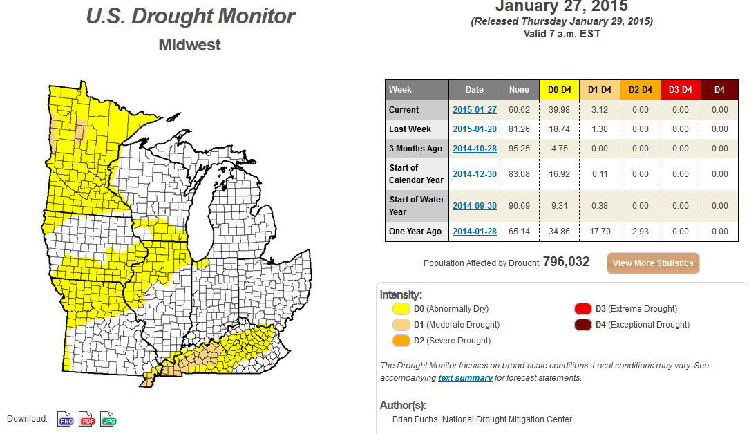
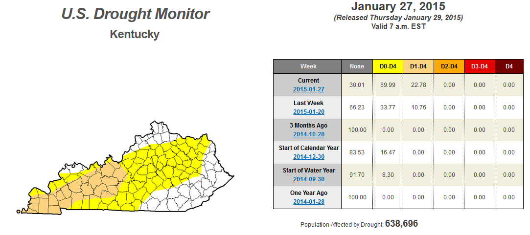
Next week will bring below normal temperatures and likely drier than normal conditions. That means not much relief on the drought front. Hopefully the weekend rain or rain/snow will help a little bit.
Portions of our region are in moderate drought (the tan color). The yellow area is considered abnormally dry. This does cover part of southern Illinois, as well.
Here are the very latest drought numbers

Who do you trust for your weather information and who holds them accountable?
I have studied weather in our region since the late 1970’s. I have 37 years of experience in observing our regions weather patterns. My degree is in Broadcast Meteorology from Mississippi State University and an Associate of Science (AS). I am currently working on my Bachelor’s Degree in Geoscience. Just need to finish two Spanish classes!
I am a member of the American Meteorological Society. I am a NOAA Weather-Ready Nation Ambassador. And, I am the Meteorologist for McCracken County Emergency Management.
I own and operate the Southern Illinois Weather Observatory.
There is a lot of noise on the internet. A lot of weather maps are posted without explanation. Over time you should learn who to trust for your weather information.
My forecast philosophy is simple and straight forward.
- Communicate in simple terms
- To be as accurate as possible within a reasonable time frame before an event
- Interact with you on Twitter, Facebook, and the blog
- Minimize the “hype” that you might see on television or through other weather sources
- Push you towards utilizing wall-to-wall LOCAL TV coverage during severe weather events
I am a recipient of the Mark Trail Award, WPSD Six Who Make A Difference Award, Kentucky Colonel, and the Caesar J. Fiamma” Award from the American Red Cross. In 2009 I was presented with the Kentucky Office of Highway Safety Award. I was recognized by the Kentucky House of Representatives for my service to the State of Kentucky leading up to several winter storms and severe weather outbreaks.
If you click on the image below you can read the Kentucky House of Representatives Resolution.

I am also President of the Shadow Angel Foundation which serves portions of western Kentucky and southern Illinois.

We have regional radars and local city radars – if a radar does not seem to be updating then try another one. Occasional browsers need their cache cleared. You may also try restarting your browser. That usually fixes the problem. Occasionally we do have a radar go down. That is why I have duplicates. Thus, if one fails then try another one.
If you have any problems then please send me an email beaudodson@usawx.com
WEATHER RADAR PAGE – Click here —
We also have a new national interactive radar – you can view that radar by clicking here.
Local interactive city radars include St Louis, Mt Vernon, Evansville, Poplar Bluff, Cape Girardeau, Marion, Paducah, Hopkinsville, Memphis, Nashville, Dyersburg, and all of eastern Kentucky – these are interactive radars. Local city radars – click here
NOTE: Occasionally you will see ground clutter on the radar (these are false echoes). Normally they show up close to the radar sites – including Paducah.

Regional Radar – Click on radar to take you our full radar page.


Regional Radar

Please visit your local National Weather Service Office by clicking here. The National Weather Service Office, for our region, is located in Paducah, Kentucky. They have a lot of maps and information on their site. Local people…local forecasters who care about our region.

Here is the official 6-10 day and 8-14 day temperature and precipitation outlook. Check the date stamp at the top of each image (so you understand the time frame).
The forecast maps below are issued by the Weather Prediction Center (NOAA).


The latest 8-14 day temperature and precipitation outlook. Note the dates are at the top of the image. These maps DO NOT tell you how high or low temperatures or precipitation will be. They simply give you the probability as to whether temperatures or precipitation will be above or below normal.


Many of my graphics are from www.weatherbell.com – a great resource for weather data, model data, and more


This blog was inspired by ABC 33/40’s Alabama Weather Blog – view their blog
Current tower cam view from the Weather Observatory- Click here for all cameras.

Southern Illinois Weather Observatory

The Weather Observatory

Southern Illinois Weather Observatory
WSIL TV 3 has a number of tower cameras. Click here for their tower camera page & Illinois Road Conditions

Marion, Illinois
WPSD TV 6 has a number of tower cameras. Click here for their tower camera page & Kentucky Road Conditions & Kentucky Highway and Interstate Cameras

Downtown Paducah, Kentucky
Benton, Kentucky Tower Camera – Click here for full view

Benton, Kentucky

I24 Paducah, Kentucky

I24 Mile Point 9 – Paducah, KY

I24 – Mile Point 3 Paducah, Kentucky

You can sign up for my AWARE email by clicking here I typically send out AWARE emails before severe weather, winter storms, or other active weather situations. I do not email watches or warnings. The emails are a basic “heads up” concerning incoming weather conditions.