
Updated at 9 PM Wednesday
January 3, 2018
Wednesday Night Forecast Details:
Forecast: A period of clouds. Flurries possible. Cold.
Temperatures: MO ~ 4 to 8 IL ~ 2 to 6 KY ~ 4 to 8
What is the chance of precipitation? MO ~ 20% IL ~ 20% KY ~ 20%
Coverage of precipitation: Isolated flurries
Wind chill values: -12 to 0
Accumulating snow or ice: Unlikely
Winds: Northwest at 6 to 12 mph with gusts to 18 mph
What impacts are anticipated from the weather? Cold wind chills
My confidence in the forecast verifying: High
Is severe weather expected? No
The NWS defines severe weather as 58 mph wind or great, 1″ hail or larger, and/or tornadoes
Should I cancel my outdoor plans: Cold wind chill values
.
January 4, 2018
Thursday Forecast Details
Forecast: Some morning clouds. Becoming mostly sunny. A flurry possible. Cold.
Temperatures: MO ~ 16 to 26 IL ~ 15 to 20 KY ~ 20 to 24
What is the chance of precipitation? MO ~ 10% IL ~ 10% KY ~ 10%
Coverage of precipitation: None
Wind chill values: 0 to 15 degrees
Accumulating snow or ice: No
Winds: North and northwest at 5 to 10 mph with gusts to 15 mph
What impacts are anticipated from the weather? Cold wind chills
My confidence in the forecast verifying: High
Is severe weather expected? No
The NWS defines severe weather as 58 mph wind or great, 1″ hail or larger, and/or tornadoes
Should I cancel my outdoor plans? No, but it will be cold
.
Thursday Night Forecast Details:
Forecast: A few passing clouds. Otherwise, clear and bitterly cold.
Temperatures: MO ~ 4 to 10 IL ~ 2 to 8 KY ~ 5 to 10
What is the chance of precipitation? MO ~ 0% IL ~ 0% KY ~ 0%
Coverage of precipitation: None
Wind chill values: -8 to 4 degrees above
Accumulating snow or ice: No
Winds: North and northwest at 5 to 10 mph
What impacts are anticipated from the weather? Cold wind chills
My confidence in the forecast verifying: High
Is severe weather expected? No
The NWS defines severe weather as 58 mph wind or great, 1″ hail or larger, and/or tornadoes
Should I cancel my outdoor plans: Cold wind chill values
.
January 5, 2018
Friday Forecast Details
Forecast: Intervals of clouds. A chance of flurries.
Temperatures: MO ~ 25 to 30 IL ~ 18 to 25 KY ~ 22 to 26
What is the chance of precipitation? MO ~ 20% IL ~ 20% KY ~ 20%
Coverage of precipitation: Isolated
Wind chill values: 10 to 20
Accumulating snow or ice: Unlikely
Winds: Variable at 4 to 8 mph
What impacts are anticipated from the weather? None
My confidence in the forecast verifying: Medium
Is severe weather expected? No
The NWS defines severe weather as 58 mph wind or great, 1″ hail or larger, and/or tornadoes
Should I cancel my outdoor plans? No
.
Friday Night Forecast Details:
Forecast: Clouds early and then clearing. Bitterly cold. Small chance of a flurry.
Temperatures: MO ~ 7 to 14 IL ~ 2 to 8 KY ~ 5 to 10
What is the chance of precipitation? MO ~ 10% IL ~ 10% KY ~ 10%
Coverage of precipitation: Isolated
Wind chill values: -8 to 10
Accumulating snow or ice: No
Winds: North and northast winds 5 to 10 mph
What impacts are anticipated from the weather? Cold wind chills
My confidence in the forecast verifying: Medium
Is severe weather expected? No
The NWS defines severe weather as 58 mph wind or great, 1″ hail or larger, and/or tornadoes
Should I cancel my outdoor plans: It will be quite cold
.
January 6, 2018
Saturday Forecast Details
Forecast: Mostly sunny.
Temperatures: MO ~ 26 to 32 IL ~ 25 to 30 KY ~ 25 to 30
What is the chance of precipitation? MO ~ 0% IL ~ 0% KY ~ 0%
Coverage of precipitation: None
Wind chill values: 20 to 30
Accumulating snow or ice: No
Winds: East 4 to 8 mph
What impacts are anticipated from the weather? None
My confidence in the forecast verifying: Medium
Is severe weather expected? No
The NWS defines severe weather as 58 mph wind or great, 1″ hail or larger, and/or tornadoes
Should I cancel my outdoor plans? No
.
Saturday Night Forecast Details:
Forecast: Increasing clouds. A slight chance of sleet and freezing rain after midnight.
Temperatures: MO ~ 18 to 24 IL ~ 18 to 24 KY ~ 18 to 24
What is the chance of precipitation? MO ~ 20% (late) IL ~ 20% (late) KY ~ 20%
Coverage of precipitation: Scattered after midnight
Wind chill values: 15 to 20
Accumulating snow or ice: Monitor updates. Slick roads are possible.
Winds: Southeast at 5 to 10 mph
What impacts are anticipated from the weather? Icy roads.
My confidence in the forecast verifying: Medium
Is severe weather expected? No
The NWS defines severe weather as 58 mph wind or great, 1″ hail or larger, and/or tornadoes
Should I cancel my outdoor plans: No
.
January 7, 2018
Sunday Forecast Details
Forecast: Cloudy. Freezing rain, sleet, and snow developing. Icy roads possible.
Temperatures: MO ~ 32 to 36 IL ~ 32 to 36 KY ~ 32 to 36
What is the chance of precipitation? MO ~ 60% IL ~ 60% KY ~ 60%
Coverage of precipitation: Widespread
Wind chill values: 25 to 35
Accumulating snow or ice: Monitor updates. Some ice accumulation or snow accumulation is possible.
Winds: South wind 5 to 10 mph
What impacts are anticipated from the weather? Icy roads are possible.
My confidence in the forecast verifying: Medium
Is severe weather expected? No
The NWS defines severe weather as 58 mph wind or great, 1″ hail or larger, and/or tornadoes
Should I cancel my outdoor plans? Have a plan B
.
Sunday Night Forecast Details:
Forecast: Cloudy. A chance of a wintry mix or rain. There remain questions on temperatures across our area.
Temperatures: MO ~ 33 to 36 IL ~ 33 to 36 KY ~ 33 to 36
What is the chance of precipitation? MO ~ 60% IL ~ 60% KY ~ 60%
Coverage of precipitation: Scattered
Wind chill values: 28 to 38
Accumulating snow or ice: Monitor updates
Winds: South wind becoming west at 5 to 10 mph
What impacts are anticipated from the weather? Monitor updates
My confidence in the forecast verifying: LOW
Is severe weather expected? No
The NWS defines severe weather as 58 mph wind or great, 1″ hail or larger, and/or tornadoes
Should I cancel my outdoor plans: Precipitation will be possible
.
January 8, 2018
Monday Forecast Details
Forecast: Morning clouds. Becoming partly sunny. Rain or snow showers possible early.
Temperatures: MO ~ 35 to 40 IL ~ 36 to 42 KY ~ 36 to 42
What is the chance of precipitation? MO ~ 30% IL ~ 30% KY ~ 40%
Coverage of precipitation: Scattered
Wind chill values: 30 to 40
Accumulating snow or ice: Most likely no.
Winds: Southwest and west wind 5 to 10 mph
What impacts are anticipated from the weather? Most likely none, but monitor updates.
My confidence in the forecast verifying: LOW
Is severe weather expected? No
The NWS defines severe weather as 58 mph wind or great, 1″ hail or larger, and/or tornadoes
Should I cancel my outdoor plans? Monitor updates.
.
Monday Night Forecast Details:
Forecast: Clearing. Chilly.
Temperatures: MO ~ 22 to 26 IL ~ 22 to 26 KY ~ 24 to 26
What is the chance of precipitation? MO ~ 0% IL ~ 0% KY ~ 0%
Coverage of precipitation: Most likely none
Wind chill values: 15 to 25
Accumulating snow or ice: No
Winds: North wind at 5 to 10 mph
What impacts are anticipated from the weather? None
My confidence in the forecast verifying: Medium
Is severe weather expected? No
The NWS defines severe weather as 58 mph wind or great, 1″ hail or larger, and/or tornadoes
Should I cancel my outdoor plans: No
.

.
Wednesday night through Saturday: Flurries are possible, but accumulating snow is unlikely.
Saturday night through Monday: I am monitoring a storm system that could bring a wintry mix changing to rain to the region late Saturday night into Sunday night. Temperatures may warm enough for rain. Too early for certainties.
Icy roads are possible late Saturday night into Sunday.
.

.
The National Weather Service definition of a severe thunderstorm is one that produces quarter size hail or larger, 58 mph winds or greater, and/or a tornado.
Now through next Wednesday: Severe storms are not anticipated.
.

Interactive Weather Radar Page. Choose the city nearest your location: Click this link
January 3, 2018
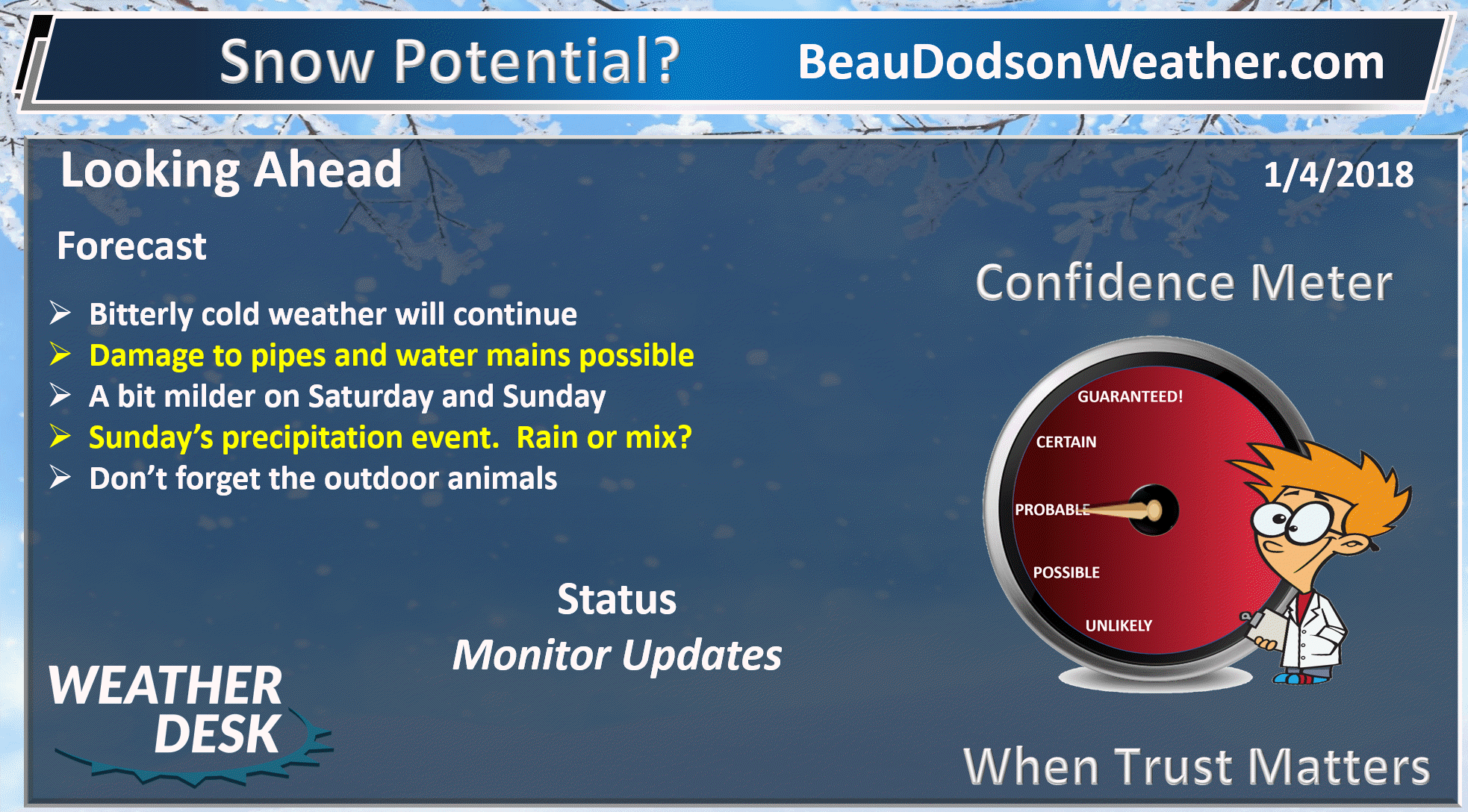
Our cold weather will continue into Saturday.
Some flurries are possible this evening as a cold front pushes through the region. Nothing of significance. The front will reinforce the cold air. That means more single digit lows tonight and tomorrow night.
Flurries are possible on Friday, as well.
It seems we can’t shake the cold weather. Dry weather will continue into Saturday evening, as well.
A stronger system will move into the region late Saturday night and especially on Sunday and Sunday night. This system will bring widespread precipitation to the region.
It appears temperatures will be on the rise as this system pushes into the area. Precipitation will begin as a wintry mix and might change to all rain by mid day on Sunday. Confidence is low to medium on the frozen vs rain. Icy roads are a possibility.
Models guidance today trended colder with the weekend system. It is possible that we will have to deal with some frozen precipitation.
Roads will be cold. There is at least some concern that rain could freeze on surfaces. Even a brief period of freezing rain could cause issues.
I will keep an eye on it.
.
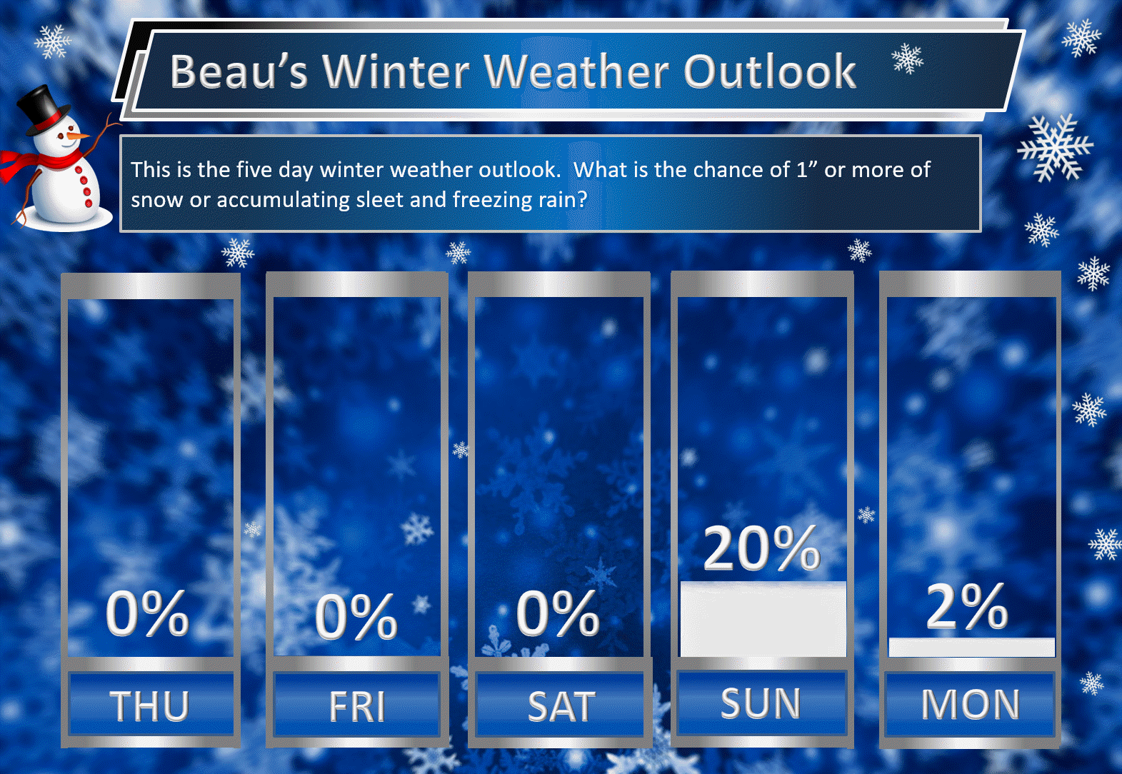
Beau’s Winter Weather Outlook
It is important to remember that this pattern is fluid. There is always going to be lower than normal confidence, during the winter months, for the forecast past day three or four.
.
.
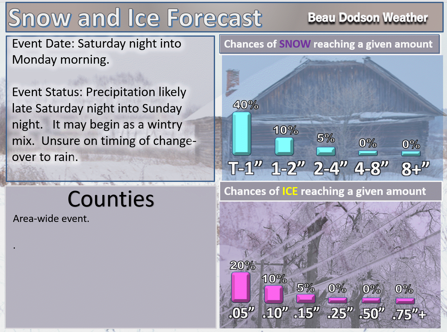
Here are my latest snow probability maps for the week ahead.
Breaking it down between snow and ice.
Just a small chance of a trace of snow on Friday. Flurries perhaps (if that).
T-1″ means a trace to one inch.
.

.
The larger system arrives on Sunday. Warmer air is forecast to surge northward and push the freezing line away from our area. The question will be what time does the precipitation arrive. If it arrives early enough, then some of it would be frozen.
It is still a bit early to know for sure. Monitor updates.
T-1″ means a trace to one inch.
.
.
These have been updated with the latest data.
These graphics show you the % chance of one inch or more of snow and/or accumulating sleet and freezing rain.
I am monitoring Friday for flurries. The Sunday system is larger. Widespread rain or wintry mix is likely on Sunday. The timing of the event will need to be monitored. The frozen precipitation may change to all rain. Warmer air is forecast to move into the area during the weekend (esp on Sunday).
.
.
Next week
.

.


We offer regional radars and local city radars – if a radar does not update then try another one. Occasional browsers need their cache cleared. You may also try restarting your browser. This will usually fix any problems.
During the winter you can track snow and ice by clicking the winterize button on the local city view interactive radars.
You may email me at beaudodson@usawx.com
Interactive Weather Radar Page. Choose the city nearest your location: Click this link
National interactive radar: Click this link.